 Note:
The expiration time in the watch graphic is amended if the watch is
replaced, cancelled or extended.
Note:
Note:
The expiration time in the watch graphic is amended if the watch is
replaced, cancelled or extended.
Note: Click for
Watch Status Reports.
SEL9
URGENT - IMMEDIATE BROADCAST REQUESTED
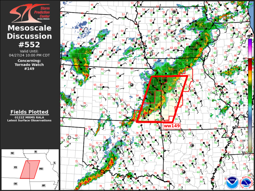
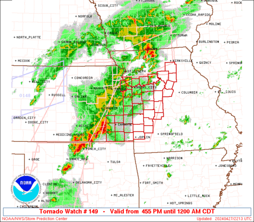
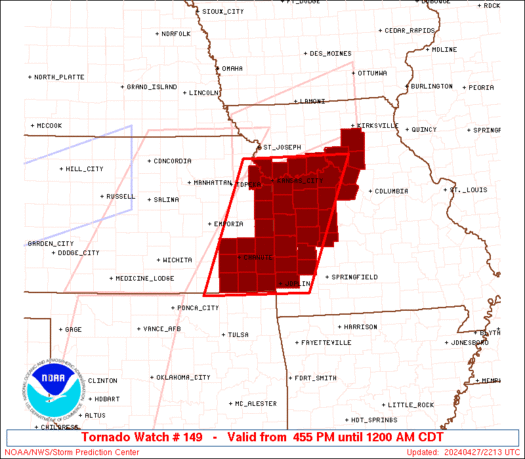
Tornado Watch Number 149
NWS Storm Prediction Center Norman OK
455 PM CDT Sat Apr 27 2024
The NWS Storm Prediction Center has issued a
* Tornado Watch for portions of
Eastern Kansas
Western and Central Missouri
* Effective this Saturday afternoon from 455 PM until Midnight
CDT.
* Primary threats include...
A few tornadoes likely with a couple intense tornadoes possible
Widespread damaging wind gusts to 70 mph likely
Scattered large hail and isolated very large hail events to 2
inches in diameter likely
SUMMARY...Thunderstorms will gradually move east into the Watch area
this evening. Increasing moisture and strengthening shear will
favor organized storms, included supercell and line segments.
Upscale growth is likely to eventually occur later this evening with
the threat transitioning to primarily a risk tornadoes and damaging
gusts.
The tornado watch area is approximately along and 70 statute miles
east and west of a line from 45 miles northeast of Kansas City MO to
35 miles west southwest of Joplin MO. For a complete depiction of
the watch see the associated watch outline update (WOUS64 KWNS
WOU9).
PRECAUTIONARY/PREPAREDNESS ACTIONS...
REMEMBER...A Tornado Watch means conditions are favorable for
tornadoes and severe thunderstorms in and close to the watch
area. Persons in these areas should be on the lookout for
threatening weather conditions and listen for later statements
and possible warnings.
&&
OTHER WATCH INFORMATION...CONTINUE...WW 145...WW 146...WW
147...WW 148...
AVIATION...Tornadoes and a few severe thunderstorms with hail
surface and aloft to 2 inches. Extreme turbulence and surface wind
gusts to 60 knots. A few cumulonimbi with maximum tops to 500. Mean
storm motion vector 24035.
...Smith
   SEL9

   URGENT - IMMEDIATE BROADCAST REQUESTED
   Tornado Watch Number 149
   NWS Storm Prediction Center Norman OK
   455 PM CDT Sat Apr 27 2024

   The NWS Storm Prediction Center has issued a

   * Tornado Watch for portions of
     Eastern Kansas
     Western and Central Missouri

   * Effective this Saturday afternoon from 455 PM until Midnight
     CDT.

   * Primary threats include...
     A few tornadoes likely with a couple intense tornadoes possible
     Widespread damaging wind gusts to 70 mph likely
     Scattered large hail and isolated very large hail events to 2
       inches in diameter likely

   SUMMARY...Thunderstorms will gradually move east into the Watch area
   this evening.  Increasing moisture and strengthening shear will
   favor organized storms, included supercell and line segments.
   Upscale growth is likely to eventually occur later this evening with
   the threat transitioning to primarily a risk tornadoes and damaging
   gusts.

   The tornado watch area is approximately along and 70 statute miles
   east and west of a line from 45 miles northeast of Kansas City MO to
   35 miles west southwest of Joplin MO. For a complete depiction of
   the watch see the associated watch outline update (WOUS64 KWNS
   WOU9).

   PRECAUTIONARY/PREPAREDNESS ACTIONS...

   REMEMBER...A Tornado Watch means conditions are favorable for
   tornadoes and severe thunderstorms in and close to the watch
   area. Persons in these areas should be on the lookout for
   threatening weather conditions and listen for later statements
   and possible warnings.

   &&

   OTHER WATCH INFORMATION...CONTINUE...WW 145...WW 146...WW
   147...WW 148...

   AVIATION...Tornadoes and a few severe thunderstorms with hail
   surface and aloft to 2 inches. Extreme turbulence and surface wind
   gusts to 60 knots. A few cumulonimbi with maximum tops to 500. Mean
   storm motion vector 24035.

   ...Smith
 Note:
The Aviation Watch (SAW) product is an approximation to the watch area.
The actual watch is depicted by the shaded areas.
Note:
The Aviation Watch (SAW) product is an approximation to the watch area.
The actual watch is depicted by the shaded areas.
   SAW9
   WW 149 TORNADO KS MO 272155Z - 280500Z
   AXIS..70 STATUTE MILES EAST AND WEST OF LINE..
   45NE MKC/KANSAS CITY MO/ - 35WSW JLN/JOPLIN MO/
   ..AVIATION COORDS.. 60NM E/W /38ENE MCI - 13SSE OSW/
   HAIL SURFACE AND ALOFT..2 INCHES. WIND GUSTS..60 KNOTS.
   MAX TOPS TO 500. MEAN STORM MOTION VECTOR 24035.

   LAT...LON 39569269 36959382 36959635 39569532

   THIS IS AN APPROXIMATION TO THE WATCH AREA.  FOR A
   COMPLETE DEPICTION OF THE WATCH SEE WOUS64 KWNS
   FOR WOU9.
Watch 149 Status Report Messages:
STATUS REPORT #2 ON WW 149

VALID 280030Z - 280140Z

SEVERE WEATHER THREAT CONTINUES RIGHT OF A LINE FROM 20 SSE EMP
TO 15 SSW OJC TO 10 SSE MKC TO 25 WSW CDJ.

..WENDT..04/28/24

ATTN...WFO...ICT...SGF...EAX...

&&

STATUS REPORT FOR WT 149

SEVERE WEATHER THREAT CONTINUES FOR THE FOLLOWING AREAS

KSC001-011-021-037-099-107-121-125-133-205-207-280140-

KS
.    KANSAS COUNTIES INCLUDED ARE

ALLEN		     BOURBON		 CHEROKEE
CRAWFORD	     LABETTE		 LINN
MIAMI		     MONTGOMERY 	 NEOSHO
WILSON		     WOODSON
$$


MOC011-013-015-033-037-039-041-053-057-083-085-089-095-097-101-
107-121-159-175-177-185-195-217-280140-

MO
.    MISSOURI COUNTIES INCLUDED ARE

BARTON		     BATES		 BENTON
CARROLL 	     CASS		 CEDAR
CHARITON	     COOPER		 DADE
HENRY		     HICKORY		 HOWARD
JACKSON 	     JASPER		 JOHNSON
LAFAYETTE	     MACON		 PETTIS
RANDOLPH	     RAY		 ST. CLAIR
SALINE		     VERNON
$$


THE WATCH STATUS MESSAGE IS FOR GUIDANCE PURPOSES ONLY.  PLEASE
REFER TO WATCH COUNTY NOTIFICATION STATEMENTS FOR OFFICIAL
INFORMATION ON COUNTIES...INDEPENDENT CITIES AND MARINE ZONES
CLEARED FROM SEVERE THUNDERSTORM AND TORNADO WATCHES.
$$

STATUS REPORT #1 ON WW 149

VALID 272350Z - 280040Z

SEVERE WEATHER THREAT CONTINUES RIGHT OF A LINE FROM 20 SSE EMP
TO 10 W OJC TO 35 WSW CDJ.

..WENDT..04/27/24

ATTN...WFO...ICT...SGF...EAX...

&&

STATUS REPORT FOR WT 149

SEVERE WEATHER THREAT CONTINUES FOR THE FOLLOWING AREAS

KSC001-011-021-037-091-099-107-121-125-133-205-207-209-280040-

KS
.    KANSAS COUNTIES INCLUDED ARE

ALLEN		     BOURBON		 CHEROKEE
CRAWFORD	     JOHNSON		 LABETTE
LINN		     MIAMI		 MONTGOMERY
NEOSHO		     WILSON		 WOODSON
WYANDOTTE
$$


MOC011-013-015-033-037-039-041-047-053-057-083-085-089-095-097-
101-107-121-159-175-177-185-195-217-280040-

MO
.    MISSOURI COUNTIES INCLUDED ARE

BARTON		     BATES		 BENTON
CARROLL 	     CASS		 CEDAR
CHARITON	     CLAY		 COOPER
DADE		     HENRY		 HICKORY
HOWARD		     JACKSON		 JASPER
JOHNSON 	     LAFAYETTE		 MACON
PETTIS		     RANDOLPH		 RAY
ST. CLAIR	     SALINE		 VERNON
$$


THE WATCH STATUS MESSAGE IS FOR GUIDANCE PURPOSES ONLY.  PLEASE
REFER TO WATCH COUNTY NOTIFICATION STATEMENTS FOR OFFICIAL
INFORMATION ON COUNTIES...INDEPENDENT CITIES AND MARINE ZONES
CLEARED FROM SEVERE THUNDERSTORM AND TORNADO WATCHES.
$$
Note:
Click for Complete Product Text.
Tornadoes
Probability of 2 or more tornadoes
|
Mod (60%)
|
Probability of 1 or more strong (EF2-EF5) tornadoes
|
Mod (40%)
|
Wind
Probability of 10 or more severe wind events
|
High (80%)
|
Probability of 1 or more wind events > 65 knots
|
Low (10%)
|
Hail
Probability of 10 or more severe hail events
|
High (70%)
|
Probability of 1 or more hailstones > 2 inches
|
Mod (60%)
|
Combined Severe Hail/Wind
Probability of 6 or more combined severe hail/wind events
|
High (>95%)
|
For each watch, probabilities for particular events inside the watch
(listed above in each table) are determined by the issuing forecaster.
The "Low" category contains probability values ranging from less than 2%
to 20% (EF2-EF5 tornadoes), less than 5% to 20% (all other probabilities),
"Moderate" from 30% to 60%, and "High" from 70% to greater than 95%.
High values are bolded and lighter in color to provide awareness of
an increased threat for a particular event.


 @NWSSPC