Note:
The expiration time in the watch graphic is amended if the watch is
replaced, cancelled or extended.
Note:
Note:
The expiration time in the watch graphic is amended if the watch is
replaced, cancelled or extended.
Note: Click for
Watch Status Reports.
SEL7
URGENT - IMMEDIATE BROADCAST REQUESTED
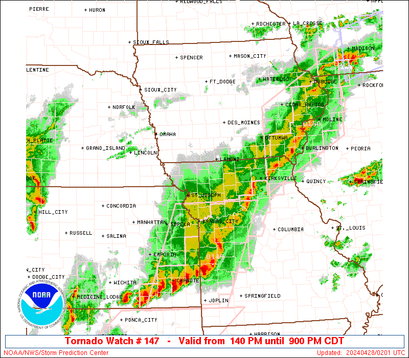
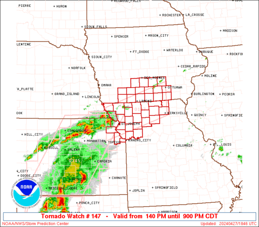
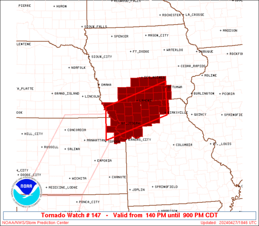
Tornado Watch Number 147
NWS Storm Prediction Center Norman OK
140 PM CDT Sat Apr 27 2024
The NWS Storm Prediction Center has issued a
* Tornado Watch for portions of
Southern Iowa
Northeast Kansas
Northern Missouri
* Effective this Saturday afternoon and evening from 140 PM until
900 PM CDT.
* Primary threats include...
A few tornadoes likely with a couple intense tornadoes possible
Scattered large hail and isolated very large hail events to 2
inches in diameter likely
Scattered damaging winds likely with isolated significant gusts
to 75 mph possible
SUMMARY...Thunderstorms will continue to develop this afternoon
along a surface boundary lying across northern Missouri and southern
Iowa. Large hail and damaging winds are possible, along with a few
tornadoes in the strongest cells.
The tornado watch area is approximately along and 45 statute miles
north and south of a line from 35 miles west of Saint Joseph MO to
30 miles south of Ottumwa IA. For a complete depiction of the watch
see the associated watch outline update (WOUS64 KWNS WOU7).
PRECAUTIONARY/PREPAREDNESS ACTIONS...
REMEMBER...A Tornado Watch means conditions are favorable for
tornadoes and severe thunderstorms in and close to the watch
area. Persons in these areas should be on the lookout for
threatening weather conditions and listen for later statements
and possible warnings.
&&
OTHER WATCH INFORMATION...CONTINUE...WW 145...WW 146...
AVIATION...Tornadoes and a few severe thunderstorms with hail
surface and aloft to 2 inches. Extreme turbulence and surface wind
gusts to 65 knots. A few cumulonimbi with maximum tops to 500. Mean
storm motion vector 25030.
...Hart
   SEL7

   URGENT - IMMEDIATE BROADCAST REQUESTED
   Tornado Watch Number 147
   NWS Storm Prediction Center Norman OK
   140 PM CDT Sat Apr 27 2024

   The NWS Storm Prediction Center has issued a

   * Tornado Watch for portions of
     Southern Iowa
     Northeast Kansas
     Northern Missouri

   * Effective this Saturday afternoon and evening from 140 PM until
     900 PM CDT.

   * Primary threats include...
     A few tornadoes likely with a couple intense tornadoes possible
     Scattered large hail and isolated very large hail events to 2
       inches in diameter likely
     Scattered damaging winds likely with isolated significant gusts
       to 75 mph possible

   SUMMARY...Thunderstorms will continue to develop this afternoon
   along a surface boundary lying across northern Missouri and southern
   Iowa.  Large hail and damaging winds are possible, along with a few
   tornadoes in the strongest cells.

   The tornado watch area is approximately along and 45 statute miles
   north and south of a line from 35 miles west of Saint Joseph MO to
   30 miles south of Ottumwa IA. For a complete depiction of the watch
   see the associated watch outline update (WOUS64 KWNS WOU7).

   PRECAUTIONARY/PREPAREDNESS ACTIONS...

   REMEMBER...A Tornado Watch means conditions are favorable for
   tornadoes and severe thunderstorms in and close to the watch
   area. Persons in these areas should be on the lookout for
   threatening weather conditions and listen for later statements
   and possible warnings.

   &&

   OTHER WATCH INFORMATION...CONTINUE...WW 145...WW 146...

   AVIATION...Tornadoes and a few severe thunderstorms with hail
   surface and aloft to 2 inches. Extreme turbulence and surface wind
   gusts to 65 knots. A few cumulonimbi with maximum tops to 500. Mean
   storm motion vector 25030.

   ...Hart
 Note:
The Aviation Watch (SAW) product is an approximation to the watch area.
The actual watch is depicted by the shaded areas.
Note:
The Aviation Watch (SAW) product is an approximation to the watch area.
The actual watch is depicted by the shaded areas.
   SAW7
   WW 147 TORNADO IA KS MO 271840Z - 280200Z
   AXIS..45 STATUTE MILES NORTH AND SOUTH OF LINE..
   35W STJ/SAINT JOSEPH MO/ - 30S OTM/OTTUMWA IA/
   ..AVIATION COORDS.. 40NM N/S /39SE PWE - 32NNE IRK/
   HAIL SURFACE AND ALOFT..2 INCHES. WIND GUSTS..65 KNOTS.
   MAX TOPS TO 500. MEAN STORM MOTION VECTOR 25030.

   LAT...LON 40419558 41329245 40009245 39129558

   THIS IS AN APPROXIMATION TO THE WATCH AREA.  FOR A
   COMPLETE DEPICTION OF THE WATCH SEE WOUS64 KWNS
   FOR WOU7.
Watch 147 Status Report Messages:
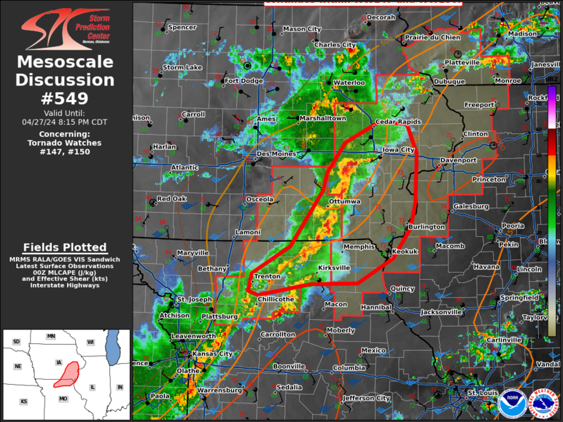
STATUS REPORT #3 ON WW 147

VALID 272345Z - 280040Z

SEVERE WEATHER THREAT CONTINUES RIGHT OF A LINE FROM 20 NNE MKC
TO 35 NW CDJ TO 45 E LWD TO 30 SW OTM TO 30 NNE OXV.

..WENDT..04/27/24

ATTN...WFO...DMX...EAX...

&&

STATUS REPORT FOR WT 147

SEVERE WEATHER THREAT CONTINUES FOR THE FOLLOWING AREAS

IAC007-051-123-135-179-280040-

IA
.    IOWA COUNTIES INCLUDED ARE

APPANOOSE	     DAVIS		 MAHASKA
MONROE		     WAPELLO
$$


MOC001-025-061-079-115-117-171-177-197-211-280040-

MO
.    MISSOURI COUNTIES INCLUDED ARE

ADAIR		     CALDWELL		 DAVIESS
GRUNDY		     LINN		 LIVINGSTON
PUTNAM		     RAY		 SCHUYLER
SULLIVAN
$$


THE WATCH STATUS MESSAGE IS FOR GUIDANCE PURPOSES ONLY.  PLEASE
REFER TO WATCH COUNTY NOTIFICATION STATEMENTS FOR OFFICIAL
INFORMATION ON COUNTIES...INDEPENDENT CITIES AND MARINE ZONES
CLEARED FROM SEVERE THUNDERSTORM AND TORNADO WATCHES.
$$

STATUS REPORT #2 ON WW 147

VALID 272230Z - 272340Z

THE SEVERE WEATHER THREAT CONTINUES ACROSS THE ENTIRE WATCH AREA.

..WENDT..04/27/24

ATTN...WFO...DMX...EAX...

&&

STATUS REPORT FOR WT 147

SEVERE WEATHER THREAT CONTINUES FOR THE FOLLOWING AREAS

IAC003-007-039-051-053-117-121-123-125-135-159-173-175-179-181-
185-272340-

IA
.    IOWA COUNTIES INCLUDED ARE

ADAMS		     APPANOOSE		 CLARKE
DAVIS		     DECATUR		 LUCAS
MADISON 	     MAHASKA		 MARION
MONROE		     RINGGOLD		 TAYLOR
UNION		     WAPELLO		 WARREN
WAYNE
$$


KSC005-043-272340-

KS
.    KANSAS COUNTIES INCLUDED ARE

ATCHISON	     DONIPHAN
$$


MOC001-003-005-021-025-049-061-063-075-079-081-087-115-117-129-
147-171-197-211-227-272340-

MO
.    MISSOURI COUNTIES INCLUDED ARE

ADAIR		     ANDREW		 ATCHISON
BUCHANAN	     CALDWELL		 CLINTON
DAVIESS 	     DEKALB		 GENTRY
GRUNDY		     HARRISON		 HOLT
LINN		     LIVINGSTON 	 MERCER
NODAWAY 	     PUTNAM		 SCHUYLER
SULLIVAN	     WORTH
$$


THE WATCH STATUS MESSAGE IS FOR GUIDANCE PURPOSES ONLY.  PLEASE
REFER TO WATCH COUNTY NOTIFICATION STATEMENTS FOR OFFICIAL
INFORMATION ON COUNTIES...INDEPENDENT CITIES AND MARINE ZONES
CLEARED FROM SEVERE THUNDERSTORM AND TORNADO WATCHES.
$$

STATUS REPORT #1 ON WW 147

VALID 272130Z - 272240Z

THE SEVERE WEATHER THREAT CONTINUES ACROSS THE ENTIRE WATCH AREA.

..WENDT..04/27/24

ATTN...WFO...DMX...EAX...

&&

STATUS REPORT FOR WT 147

SEVERE WEATHER THREAT CONTINUES FOR THE FOLLOWING AREAS

IAC003-007-039-051-053-117-121-123-125-135-159-173-175-179-181-
185-272240-

IA
.    IOWA COUNTIES INCLUDED ARE

ADAMS		     APPANOOSE		 CLARKE
DAVIS		     DECATUR		 LUCAS
MADISON 	     MAHASKA		 MARION
MONROE		     RINGGOLD		 TAYLOR
UNION		     WAPELLO		 WARREN
WAYNE
$$


KSC005-043-103-209-272240-

KS
.    KANSAS COUNTIES INCLUDED ARE

ATCHISON	     DONIPHAN		 LEAVENWORTH
WYANDOTTE
$$


MOC001-003-005-021-025-047-049-061-063-075-079-081-087-115-117-
129-147-165-171-177-197-211-227-272240-

MO
.    MISSOURI COUNTIES INCLUDED ARE

ADAIR		     ANDREW		 ATCHISON
BUCHANAN	     CALDWELL		 CLAY
CLINTON 	     DAVIESS		 DEKALB
GENTRY		     GRUNDY		 HARRISON
HOLT		     LINN		 LIVINGSTON
MERCER		     NODAWAY		 PLATTE
PUTNAM		     RAY		 SCHUYLER
SULLIVAN	     WORTH
$$


THE WATCH STATUS MESSAGE IS FOR GUIDANCE PURPOSES ONLY.  PLEASE
REFER TO WATCH COUNTY NOTIFICATION STATEMENTS FOR OFFICIAL
INFORMATION ON COUNTIES...INDEPENDENT CITIES AND MARINE ZONES
CLEARED FROM SEVERE THUNDERSTORM AND TORNADO WATCHES.
$$
Note:
Click for Complete Product Text.
Tornadoes
Probability of 2 or more tornadoes
|
Mod (60%)
|
Probability of 1 or more strong (EF2-EF5) tornadoes
|
Mod (40%)
|
Wind
Probability of 10 or more severe wind events
|
High (70%)
|
Probability of 1 or more wind events > 65 knots
|
Mod (30%)
|
Hail
Probability of 10 or more severe hail events
|
High (70%)
|
Probability of 1 or more hailstones > 2 inches
|
Mod (60%)
|
Combined Severe Hail/Wind
Probability of 6 or more combined severe hail/wind events
|
High (>95%)
|
For each watch, probabilities for particular events inside the watch
(listed above in each table) are determined by the issuing forecaster.
The "Low" category contains probability values ranging from less than 2%
to 20% (EF2-EF5 tornadoes), less than 5% to 20% (all other probabilities),
"Moderate" from 30% to 60%, and "High" from 70% to greater than 95%.
High values are bolded and lighter in color to provide awareness of
an increased threat for a particular event.


 @NWSSPC