 Note:
The expiration time in the watch graphic is amended if the watch is
replaced, cancelled or extended.
Note:
Note:
The expiration time in the watch graphic is amended if the watch is
replaced, cancelled or extended.
Note: Click for
Watch Status Reports.
SEL6
URGENT - IMMEDIATE BROADCAST REQUESTED
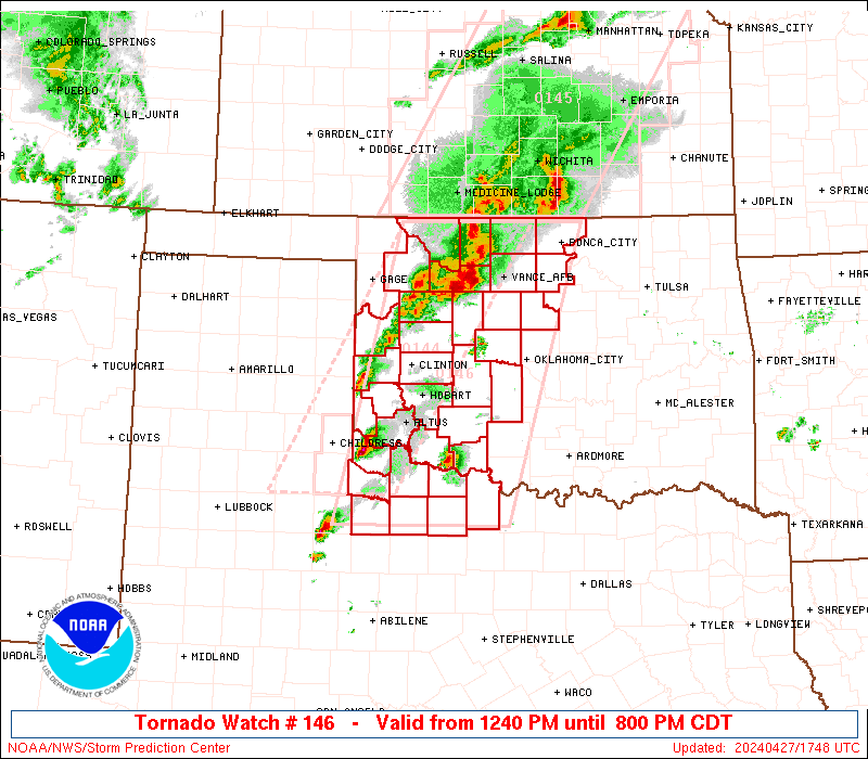
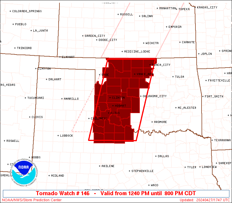
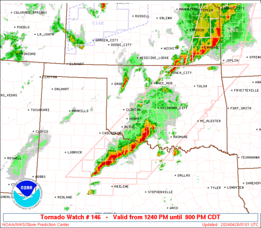
Tornado Watch Number 146
NWS Storm Prediction Center Norman OK
1240 PM CDT Sat Apr 27 2024
The NWS Storm Prediction Center has issued a
* Tornado Watch for portions of
Western Oklahoma
Northwest Texas
* Effective this Saturday afternoon and evening from 1240 PM
until 800 PM CDT.
...THIS IS A PARTICULARLY DANGEROUS SITUATION...
* Primary threats include...
Several tornadoes and a few intense tornadoes likely
Widespread large hail and scattered very large hail events to 3
inches in diameter likely
Widespread damaging winds and isolated significant gusts to 75
mph likely
SUMMARY...Intense thunderstorms are expected to develop this
afternoon along and east of a dryline over western Oklahoma and
northwest Texas. Supercells are expected, capable of very large
hail and damaging winds. The most intense cells may also produce
strong or potentially long-tracked tornadoes.
The tornado watch area is approximately along and 70 statute miles
east and west of a line from 35 miles east northeast of Alva OK to
45 miles southwest of Wichita Falls TX. For a complete depiction of
the watch see the associated watch outline update (WOUS64 KWNS
WOU6).
PRECAUTIONARY/PREPAREDNESS ACTIONS...
REMEMBER...A Tornado Watch means conditions are favorable for
tornadoes and severe thunderstorms in and close to the watch
area. Persons in these areas should be on the lookout for
threatening weather conditions and listen for later statements
and possible warnings.
&&
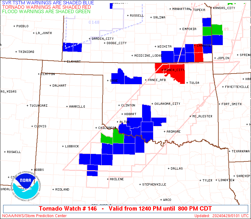
OTHER WATCH INFORMATION...CONTINUE...WW 144...WW 145...
AVIATION...Tornadoes and a few severe thunderstorms with hail
surface and aloft to 3 inches. Extreme turbulence and surface wind
gusts to 65 knots. A few cumulonimbi with maximum tops to 500. Mean
storm motion vector 24035.
...Hart

   SEL6

   URGENT - IMMEDIATE BROADCAST REQUESTED
   Tornado Watch Number 146
   NWS Storm Prediction Center Norman OK
   1240 PM CDT Sat Apr 27 2024

   The NWS Storm Prediction Center has issued a

   * Tornado Watch for portions of
     Western Oklahoma
     Northwest Texas

   * Effective this Saturday afternoon and evening from 1240 PM
     until 800 PM CDT.

   ...THIS IS A PARTICULARLY DANGEROUS SITUATION...

   * Primary threats include...
     Several tornadoes and a few intense tornadoes likely
     Widespread large hail and scattered very large hail events to 3
       inches in diameter likely
     Widespread damaging winds and isolated significant gusts to 75
       mph likely

   SUMMARY...Intense thunderstorms are expected to develop this
   afternoon along and east of a dryline over western Oklahoma and
   northwest Texas.  Supercells are expected, capable of very large
   hail and damaging winds.  The most intense cells may also produce
   strong or potentially long-tracked tornadoes.

   The tornado watch area is approximately along and 70 statute miles
   east and west of a line from 35 miles east northeast of Alva OK to
   45 miles southwest of Wichita Falls TX. For a complete depiction of
   the watch see the associated watch outline update (WOUS64 KWNS
   WOU6).

   PRECAUTIONARY/PREPAREDNESS ACTIONS...

   REMEMBER...A Tornado Watch means conditions are favorable for
   tornadoes and severe thunderstorms in and close to the watch
   area. Persons in these areas should be on the lookout for
   threatening weather conditions and listen for later statements
   and possible warnings.

   &&

   OTHER WATCH INFORMATION...CONTINUE...WW 144...WW 145...

   AVIATION...Tornadoes and a few severe thunderstorms with hail
   surface and aloft to 3 inches. Extreme turbulence and surface wind
   gusts to 65 knots. A few cumulonimbi with maximum tops to 500. Mean
   storm motion vector 24035.

   ...Hart
 Note:
The Aviation Watch (SAW) product is an approximation to the watch area.
The actual watch is depicted by the shaded areas.
Note:
The Aviation Watch (SAW) product is an approximation to the watch area.
The actual watch is depicted by the shaded areas.
   SAW6
   WW 146 TORNADO OK TX 271740Z - 280100Z
   AXIS..70 STATUTE MILES EAST AND WEST OF LINE..
   35ENE AVK/ALVA OK/ - 45SW SPS/WICHITA FALLS TX/
   ..AVIATION COORDS.. 60NM E/W /38NNW END - 37SW SPS/
   HAIL SURFACE AND ALOFT..3 INCHES. WIND GUSTS..65 KNOTS.
   MAX TOPS TO 500. MEAN STORM MOTION VECTOR 24035.

   LAT...LON 36969682 33509784 33500027 36969935

   THIS IS AN APPROXIMATION TO THE WATCH AREA.  FOR A
   COMPLETE DEPICTION OF THE WATCH SEE WOUS64 KWNS
   FOR WOU6.
Watch 146 Status Report Messages:
STATUS REPORT #5 ON WW 146
VALID 272355Z - 280040Z
THE SEVERE WEATHER THREAT CONTINUES ACROSS THE ENTIRE WATCH AREA.
..WENDT..04/27/24
ATTN...WFO...OUN...
&&
STATUS REPORT FOR WT 146
SEVERE WEATHER THREAT CONTINUES FOR THE FOLLOWING AREAS
OKC003-009-011-015-017-027-031-033-039-043-047-049-051-053-055-
057-065-067-071-073-075-083-087-093-103-109-119-129-137-141-149-
151-153-280040-
OK
. OKLAHOMA COUNTIES INCLUDED ARE
ALFALFA BECKHAM BLAINE
CADDO CANADIAN CLEVELAND
COMANCHE COTTON CUSTER
DEWEY GARFIELD GARVIN
GRADY GRANT GREER
HARMON JACKSON JEFFERSON
KAY KINGFISHER KIOWA
LOGAN MCCLAIN MAJOR
NOBLE OKLAHOMA PAYNE
ROGER MILLS STEPHENS TILLMAN
WASHITA WOODS WOODWARD
$$
TXC009-023-077-155-197-275-485-487-280040-
TX
. TEXAS COUNTIES INCLUDED ARE
ARCHER BAYLOR CLAY
FOARD HARDEMAN KNOX
WICHITA WILBARGER
$$
THE WATCH STATUS MESSAGE IS FOR GUIDANCE PURPOSES ONLY. PLEASE
REFER TO WATCH COUNTY NOTIFICATION STATEMENTS FOR OFFICIAL
INFORMATION ON COUNTIES...INDEPENDENT CITIES AND MARINE ZONES
CLEARED FROM SEVERE THUNDERSTORM AND TORNADO WATCHES.
$$
STATUS REPORT #4 ON WW 146
VALID 272230Z - 272340Z
THE SEVERE WEATHER THREAT CONTINUES ACROSS THE ENTIRE WATCH AREA.
..WENDT..04/27/24
ATTN...WFO...OUN...
&&
STATUS REPORT FOR WT 146
SEVERE WEATHER THREAT CONTINUES FOR THE FOLLOWING AREAS
OKC003-009-011-015-017-027-031-033-039-043-047-049-051-053-055-
057-065-067-071-073-075-083-087-093-103-109-119-129-137-141-149-
151-153-272340-
OK
. OKLAHOMA COUNTIES INCLUDED ARE
ALFALFA BECKHAM BLAINE
CADDO CANADIAN CLEVELAND
COMANCHE COTTON CUSTER
DEWEY GARFIELD GARVIN
GRADY GRANT GREER
HARMON JACKSON JEFFERSON
KAY KINGFISHER KIOWA
LOGAN MCCLAIN MAJOR
NOBLE OKLAHOMA PAYNE
ROGER MILLS STEPHENS TILLMAN
WASHITA WOODS WOODWARD
$$
TXC009-023-077-155-197-275-485-487-272340-
TX
. TEXAS COUNTIES INCLUDED ARE
ARCHER BAYLOR CLAY
FOARD HARDEMAN KNOX
WICHITA WILBARGER
$$
THE WATCH STATUS MESSAGE IS FOR GUIDANCE PURPOSES ONLY. PLEASE
REFER TO WATCH COUNTY NOTIFICATION STATEMENTS FOR OFFICIAL
INFORMATION ON COUNTIES...INDEPENDENT CITIES AND MARINE ZONES
CLEARED FROM SEVERE THUNDERSTORM AND TORNADO WATCHES.
$$
STATUS REPORT #3 ON WW 146
VALID 272130Z - 272240Z
THE SEVERE WEATHER THREAT CONTINUES ACROSS THE ENTIRE WATCH AREA.
..WENDT..04/27/24
ATTN...WFO...OUN...
&&
STATUS REPORT FOR WT 146
SEVERE WEATHER THREAT CONTINUES FOR THE FOLLOWING AREAS
OKC003-009-011-015-017-027-031-033-039-043-047-049-051-053-055-
057-065-067-071-073-075-083-087-093-103-109-119-129-137-141-149-
151-153-272240-
OK
. OKLAHOMA COUNTIES INCLUDED ARE
ALFALFA BECKHAM BLAINE
CADDO CANADIAN CLEVELAND
COMANCHE COTTON CUSTER
DEWEY GARFIELD GARVIN
GRADY GRANT GREER
HARMON JACKSON JEFFERSON
KAY KINGFISHER KIOWA
LOGAN MCCLAIN MAJOR
NOBLE OKLAHOMA PAYNE
ROGER MILLS STEPHENS TILLMAN
WASHITA WOODS WOODWARD
$$
TXC009-023-077-155-197-275-485-487-272240-
TX
. TEXAS COUNTIES INCLUDED ARE
ARCHER BAYLOR CLAY
FOARD HARDEMAN KNOX
WICHITA WILBARGER
$$
THE WATCH STATUS MESSAGE IS FOR GUIDANCE PURPOSES ONLY. PLEASE
REFER TO WATCH COUNTY NOTIFICATION STATEMENTS FOR OFFICIAL
INFORMATION ON COUNTIES...INDEPENDENT CITIES AND MARINE ZONES
CLEARED FROM SEVERE THUNDERSTORM AND TORNADO WATCHES.
$$
STATUS REPORT #2 ON WW 146
VALID 272035Z - 272140Z
THE SEVERE WEATHER THREAT CONTINUES ACROSS THE ENTIRE WATCH AREA.
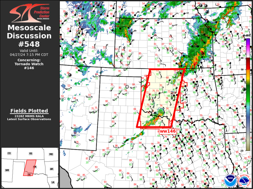
FOR ADDITIONAL INFORMATION SEE MESOSCALE DISCUSSION 544.
..GRAMS..04/27/24
ATTN...WFO...OUN...
&&
STATUS REPORT FOR WT 146
SEVERE WEATHER THREAT CONTINUES FOR THE FOLLOWING AREAS
OKC003-009-011-015-017-027-031-033-039-043-047-049-051-053-055-
057-065-067-071-073-075-083-087-093-103-109-119-129-137-141-149-
151-153-272140-
OK
. OKLAHOMA COUNTIES INCLUDED ARE
ALFALFA BECKHAM BLAINE
CADDO CANADIAN CLEVELAND
COMANCHE COTTON CUSTER
DEWEY GARFIELD GARVIN
GRADY GRANT GREER
HARMON JACKSON JEFFERSON
KAY KINGFISHER KIOWA
LOGAN MCCLAIN MAJOR
NOBLE OKLAHOMA PAYNE
ROGER MILLS STEPHENS TILLMAN
WASHITA WOODS WOODWARD
$$
TXC009-023-077-155-197-275-485-487-272140-
TX
. TEXAS COUNTIES INCLUDED ARE
ARCHER BAYLOR CLAY
FOARD HARDEMAN KNOX
WICHITA WILBARGER
$$
THE WATCH STATUS MESSAGE IS FOR GUIDANCE PURPOSES ONLY. PLEASE
REFER TO WATCH COUNTY NOTIFICATION STATEMENTS FOR OFFICIAL
INFORMATION ON COUNTIES...INDEPENDENT CITIES AND MARINE ZONES
CLEARED FROM SEVERE THUNDERSTORM AND TORNADO WATCHES.
$$
STATUS REPORT #1 ON WW 146
VALID 271920Z - 272040Z
THE SEVERE WEATHER THREAT CONTINUES ACROSS THE ENTIRE WATCH AREA.
FOR ADDITIONAL INFORMATION SEE MESOSCALE DISCUSSIONS 0541 AND 0543.
..GRAMS..04/27/24
ATTN...WFO...OUN...
&&
STATUS REPORT FOR WT 146
SEVERE WEATHER THREAT CONTINUES FOR THE FOLLOWING AREAS
OKC003-009-011-015-017-027-031-033-039-043-047-049-051-053-055-
057-065-067-071-073-075-083-087-093-103-109-119-129-137-141-149-
151-153-272040-
OK
. OKLAHOMA COUNTIES INCLUDED ARE
ALFALFA BECKHAM BLAINE
CADDO CANADIAN CLEVELAND
COMANCHE COTTON CUSTER
DEWEY GARFIELD GARVIN
GRADY GRANT GREER
HARMON JACKSON JEFFERSON
KAY KINGFISHER KIOWA
LOGAN MCCLAIN MAJOR
NOBLE OKLAHOMA PAYNE
ROGER MILLS STEPHENS TILLMAN
WASHITA WOODS WOODWARD
$$
TXC009-023-077-155-197-275-485-487-272040-
TX
. TEXAS COUNTIES INCLUDED ARE
ARCHER BAYLOR CLAY
FOARD HARDEMAN KNOX
WICHITA WILBARGER
$$
THE WATCH STATUS MESSAGE IS FOR GUIDANCE PURPOSES ONLY. PLEASE
REFER TO WATCH COUNTY NOTIFICATION STATEMENTS FOR OFFICIAL
INFORMATION ON COUNTIES...INDEPENDENT CITIES AND MARINE ZONES
CLEARED FROM SEVERE THUNDERSTORM AND TORNADO WATCHES.
$$
Note:
Click for Complete Product Text.
Tornadoes
Probability of 2 or more tornadoes
|
High (80%)
|
Probability of 1 or more strong (EF2-EF5) tornadoes
|
High (80%)
|
Wind
Probability of 10 or more severe wind events
|
High (80%)
|
Probability of 1 or more wind events > 65 knots
|
Mod (60%)
|
Hail
Probability of 10 or more severe hail events
|
High (90%)
|
Probability of 1 or more hailstones > 2 inches
|
High (80%)
|
Combined Severe Hail/Wind
Probability of 6 or more combined severe hail/wind events
|
High (>95%)
|
For each watch, probabilities for particular events inside the watch
(listed above in each table) are determined by the issuing forecaster.
The "Low" category contains probability values ranging from less than 2%
to 20% (EF2-EF5 tornadoes), less than 5% to 20% (all other probabilities),
"Moderate" from 30% to 60%, and "High" from 70% to greater than 95%.
High values are bolded and lighter in color to provide awareness of
an increased threat for a particular event.


 @NWSSPC