 Note:
The expiration time in the watch graphic is amended if the watch is
replaced, cancelled or extended.
Note:
Note:
The expiration time in the watch graphic is amended if the watch is
replaced, cancelled or extended.
Note: Click for
Watch Status Reports.
SEL5
URGENT - IMMEDIATE BROADCAST REQUESTED
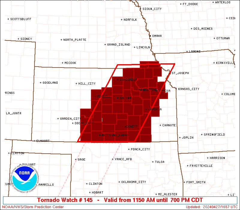
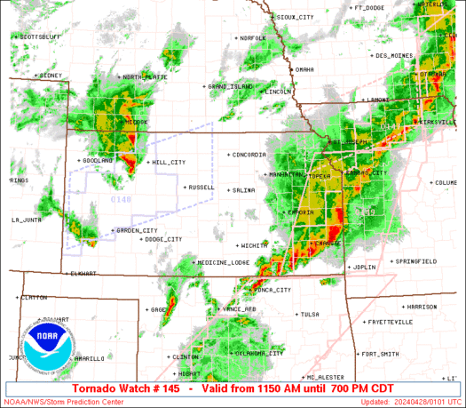
Tornado Watch Number 145
NWS Storm Prediction Center Norman OK
1150 AM CDT Sat Apr 27 2024
The NWS Storm Prediction Center has issued a
* Tornado Watch for portions of
Central and Northeast Kansas
Southeast Nebraska
* Effective this Saturday morning and evening from 1150 AM until
700 PM CDT.
* Primary threats include...
A few tornadoes and a couple intense tornadoes likely
Widespread large hail and scattered very large hail events to
2.5 inches in diameter likely
Scattered damaging winds likely with isolated significant gusts
to 75 mph possible
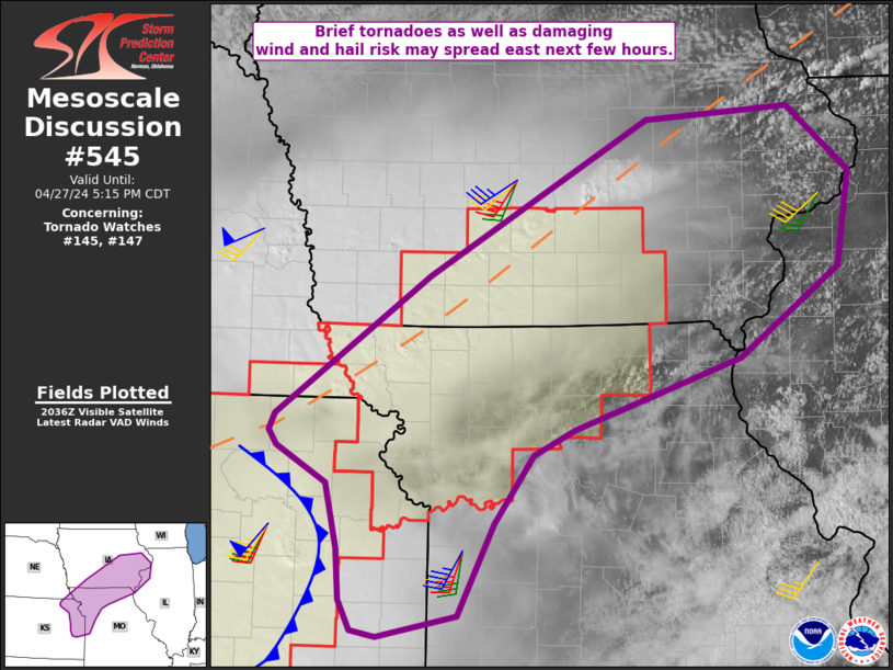
SUMMARY...Thunderstorms will develop across parts of central and
northeast Kansas through the afternoon in a very moist and unstable
environment. The strongest cells will be supercells capable of very
large hail and tornadoes. A few strong tornadoes are possible.
The tornado watch area is approximately along and 80 statute miles
east and west of a line from 70 miles west northwest of Saint Joseph
MO to 25 miles southeast of Medicine Lodge KS. For a complete
depiction of the watch see the associated watch outline update
(WOUS64 KWNS WOU5).
PRECAUTIONARY/PREPAREDNESS ACTIONS...
REMEMBER...A Tornado Watch means conditions are favorable for
tornadoes and severe thunderstorms in and close to the watch
area. Persons in these areas should be on the lookout for
threatening weather conditions and listen for later statements
and possible warnings.
&&
OTHER WATCH INFORMATION...CONTINUE...WW 144...
AVIATION...Tornadoes and a few severe thunderstorms with hail
surface and aloft to 2.5 inches. Extreme turbulence and surface wind
gusts to 65 knots. A few cumulonimbi with maximum tops to 500. Mean
storm motion vector 25030.
...Hart
 Note:
The Aviation Watch (SAW) product is an approximation to the watch area.
The actual watch is depicted by the shaded areas.
Note:
The Aviation Watch (SAW) product is an approximation to the watch area.
The actual watch is depicted by the shaded areas.
   SAW5
   WW 145 TORNADO KS NE 271650Z - 280000Z
   AXIS..80 STATUTE MILES EAST AND WEST OF LINE..
   70WNW STJ/SAINT JOSEPH MO/ - 25SE P28/MEDICINE LODGE KS/
   ..AVIATION COORDS.. 70NM E/W /4SE PWE - 44NNW END/
   HAIL SURFACE AND ALOFT..2.5 INCHES. WIND GUSTS..65 KNOTS.
   MAX TOPS TO 500. MEAN STORM MOTION VECTOR 25030.

   LAT...LON 40149463 37029681 37029971 40149766

   THIS IS AN APPROXIMATION TO THE WATCH AREA.  FOR A
   COMPLETE DEPICTION OF THE WATCH SEE WOUS64 KWNS
   FOR WOU5.
Watch 145 Status Report Messages:
STATUS REPORT #4 ON WW 145

VALID 272350Z - 280040Z

SEVERE WEATHER THREAT CONTINUES RIGHT OF A LINE FROM 20 NW PNC TO
25 ENE ICT TO 15 SSW EMP TO 35 SSE TOP.

..WENDT..04/27/24

ATTN...WFO...DDC...ICT...TOP...OAX...

&&

STATUS REPORT FOR WT 145

SEVERE WEATHER THREAT CONTINUES FOR THE FOLLOWING AREAS

KSC003-015-019-031-035-049-059-073-280040-

KS
.    KANSAS COUNTIES INCLUDED ARE

ANDERSON	     BUTLER		 CHAUTAUQUA
COFFEY		     COWLEY		 ELK
FRANKLIN	     GREENWOOD
$$


THE WATCH STATUS MESSAGE IS FOR GUIDANCE PURPOSES ONLY.  PLEASE
REFER TO WATCH COUNTY NOTIFICATION STATEMENTS FOR OFFICIAL
INFORMATION ON COUNTIES...INDEPENDENT CITIES AND MARINE ZONES
CLEARED FROM SEVERE THUNDERSTORM AND TORNADO WATCHES.
$$

STATUS REPORT #3 ON WW 145

VALID 272235Z - 272340Z

SEVERE WEATHER THREAT CONTINUES RIGHT OF A LINE FROM 55 W AVK TO
45 NE DDC TO 20 N RSL TO 30 SW CNK TO 25 SSW SLN TO 5 NW ICT TO
30 WSW EMP TO 30 N TOP TO 15 E STJ.

..WENDT..04/27/24

ATTN...WFO...DDC...ICT...TOP...OAX...

&&

STATUS REPORT FOR WT 145

SEVERE WEATHER THREAT CONTINUES FOR THE FOLLOWING AREAS

KSC003-007-009-015-019-031-033-035-045-047-049-053-059-073-077-
087-095-097-105-111-139-145-151-155-159-167-177-185-191-
272340-

KS
.    KANSAS COUNTIES INCLUDED ARE

ANDERSON	     BARBER		 BARTON
BUTLER		     CHAUTAUQUA 	 COFFEY
COMANCHE	     COWLEY		 DOUGLAS
EDWARDS 	     ELK		 ELLSWORTH
FRANKLIN	     GREENWOOD		 HARPER
JEFFERSON	     KINGMAN		 KIOWA
LINCOLN 	     LYON		 OSAGE
PAWNEE		     PRATT		 RENO
RICE		     RUSSELL		 SHAWNEE
STAFFORD	     SUMNER
$$


THE WATCH STATUS MESSAGE IS FOR GUIDANCE PURPOSES ONLY.  PLEASE
REFER TO WATCH COUNTY NOTIFICATION STATEMENTS FOR OFFICIAL
INFORMATION ON COUNTIES...INDEPENDENT CITIES AND MARINE ZONES
CLEARED FROM SEVERE THUNDERSTORM AND TORNADO WATCHES.
$$

STATUS REPORT #2 ON WW 145

VALID 272130Z - 272240Z

THE SEVERE WEATHER THREAT CONTINUES ACROSS THE ENTIRE WATCH AREA.

..WENDT..04/27/24

ATTN...WFO...DDC...ICT...TOP...OAX...

&&

STATUS REPORT FOR WT 145

SEVERE WEATHER THREAT CONTINUES FOR THE FOLLOWING AREAS

KSC007-009-013-015-017-019-027-029-031-033-035-041-045-047-049-
053-061-073-077-079-085-087-095-097-105-111-113-115-117-127-131-
139-143-145-149-151-155-159-161-167-169-173-177-185-191-197-201-
272240-

KS
.    KANSAS COUNTIES INCLUDED ARE

BARBER		     BARTON		 BROWN
BUTLER		     CHASE		 CHAUTAUQUA
CLAY		     CLOUD		 COFFEY
COMANCHE	     COWLEY		 DICKINSON
DOUGLAS 	     EDWARDS		 ELK
ELLSWORTH	     GEARY		 GREENWOOD
HARPER		     HARVEY		 JACKSON
JEFFERSON	     KINGMAN		 KIOWA
LINCOLN 	     LYON		 MCPHERSON
MARION		     MARSHALL		 MORRIS
NEMAHA		     OSAGE		 OTTAWA
PAWNEE		     POTTAWATOMIE	 PRATT
RENO		     RICE		 RILEY
RUSSELL 	     SALINE		 SEDGWICK
SHAWNEE 	     STAFFORD		 SUMNER
WABAUNSEE	     WASHINGTON
$$


NEC133-147-272240-

NE
.    NEBRASKA COUNTIES INCLUDED ARE

PAWNEE		     RICHARDSON
$$


THE WATCH STATUS MESSAGE IS FOR GUIDANCE PURPOSES ONLY.  PLEASE
REFER TO WATCH COUNTY NOTIFICATION STATEMENTS FOR OFFICIAL
INFORMATION ON COUNTIES...INDEPENDENT CITIES AND MARINE ZONES
CLEARED FROM SEVERE THUNDERSTORM AND TORNADO WATCHES.
$$

STATUS REPORT #1 ON WW 145

VALID 271905Z - 272040Z

THE SEVERE WEATHER THREAT CONTINUES ACROSS THE ENTIRE WATCH AREA.

..JEWELL..04/27/24

ATTN...WFO...DDC...ICT...TOP...OAX...

&&

STATUS REPORT FOR WT 145

SEVERE WEATHER THREAT CONTINUES FOR THE FOLLOWING AREAS

KSC007-009-013-015-017-019-027-029-031-033-035-041-045-047-049-
053-061-073-077-079-085-087-095-097-105-111-113-115-117-127-131-
139-143-145-149-151-155-159-161-167-169-173-177-185-191-197-201-
272040-

KS
.    KANSAS COUNTIES INCLUDED ARE

BARBER		     BARTON		 BROWN
BUTLER		     CHASE		 CHAUTAUQUA
CLAY		     CLOUD		 COFFEY
COMANCHE	     COWLEY		 DICKINSON
DOUGLAS 	     EDWARDS		 ELK
ELLSWORTH	     GEARY		 GREENWOOD
HARPER		     HARVEY		 JACKSON
JEFFERSON	     KINGMAN		 KIOWA
LINCOLN 	     LYON		 MCPHERSON
MARION		     MARSHALL		 MORRIS
NEMAHA		     OSAGE		 OTTAWA
PAWNEE		     POTTAWATOMIE	 PRATT
RENO		     RICE		 RILEY
RUSSELL 	     SALINE		 SEDGWICK
SHAWNEE 	     STAFFORD		 SUMNER
WABAUNSEE	     WASHINGTON
$$


NEC133-147-272040-

NE
.    NEBRASKA COUNTIES INCLUDED ARE

PAWNEE		     RICHARDSON
$$


THE WATCH STATUS MESSAGE IS FOR GUIDANCE PURPOSES ONLY.  PLEASE
REFER TO WATCH COUNTY NOTIFICATION STATEMENTS FOR OFFICIAL
INFORMATION ON COUNTIES...INDEPENDENT CITIES AND MARINE ZONES
CLEARED FROM SEVERE THUNDERSTORM AND TORNADO WATCHES.
$$
Note:
Click for Complete Product Text.
Tornadoes
Probability of 2 or more tornadoes
|
High (70%)
|
Probability of 1 or more strong (EF2-EF5) tornadoes
|
Mod (60%)
|
Wind
Probability of 10 or more severe wind events
|
Mod (60%)
|
Probability of 1 or more wind events > 65 knots
|
Mod (30%)
|
Hail
Probability of 10 or more severe hail events
|
High (80%)
|
Probability of 1 or more hailstones > 2 inches
|
High (80%)
|
Combined Severe Hail/Wind
Probability of 6 or more combined severe hail/wind events
|
High (>95%)
|
For each watch, probabilities for particular events inside the watch
(listed above in each table) are determined by the issuing forecaster.
The "Low" category contains probability values ranging from less than 2%
to 20% (EF2-EF5 tornadoes), less than 5% to 20% (all other probabilities),
"Moderate" from 30% to 60%, and "High" from 70% to greater than 95%.
High values are bolded and lighter in color to provide awareness of
an increased threat for a particular event.


 @NWSSPC