 Note:
The expiration time in the watch graphic is amended if the watch is
replaced, cancelled or extended.
Note:
Note:
The expiration time in the watch graphic is amended if the watch is
replaced, cancelled or extended.
Note: Click for
Watch Status Reports.
SEL8
URGENT - IMMEDIATE BROADCAST REQUESTED
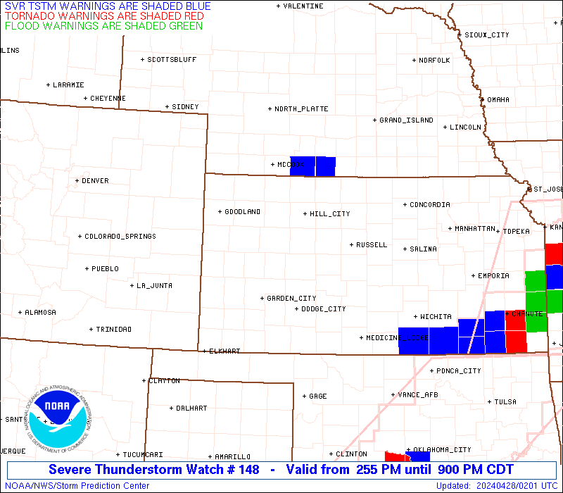
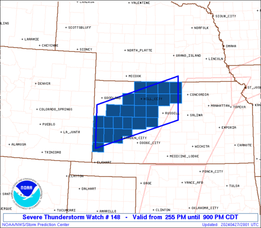
Severe Thunderstorm Watch Number 148
NWS Storm Prediction Center Norman OK
255 PM CDT Sat Apr 27 2024
The NWS Storm Prediction Center has issued a
* Severe Thunderstorm Watch for portions of
Western Kansas
* Effective this Saturday afternoon and evening from 255 PM until
900 PM CDT.
* Primary threats include...
Scattered large hail and isolated very large hail events to 2
inches in diameter likely
Scattered damaging wind gusts to 70 mph likely
A tornado or two possible
SUMMARY...Thunderstorms will develop along a surface boundary across
western Kansas this afternoon. The stronger cells will pose a risk
of large hail.
The severe thunderstorm watch area is approximately along and 55
statute miles north and south of a line from 70 miles west northwest
of Garden City KS to 55 miles northeast of Russell KS. For a
complete depiction of the watch see the associated watch outline
update (WOUS64 KWNS WOU8).
PRECAUTIONARY/PREPAREDNESS ACTIONS...
REMEMBER...A Severe Thunderstorm Watch means conditions are
favorable for severe thunderstorms in and close to the watch area.
Persons in these areas should be on the lookout for threatening
weather conditions and listen for later statements and possible
warnings. Severe thunderstorms can and occasionally do produce
tornadoes.
&&
OTHER WATCH INFORMATION...CONTINUE...WW 145...WW 146...WW 147...
AVIATION...A few severe thunderstorms with hail surface and aloft to
2 inches. Extreme turbulence and surface wind gusts to 60 knots. A
few cumulonimbi with maximum tops to 500. Mean storm motion vector
24035.
...Hart
 Note:
The Aviation Watch (SAW) product is an approximation to the watch area.
The actual watch is depicted by the shaded areas.
Note:
The Aviation Watch (SAW) product is an approximation to the watch area.
The actual watch is depicted by the shaded areas.
   SAW8
   WW 148 SEVERE TSTM KS 271955Z - 280200Z
   AXIS..55 STATUTE MILES NORTH AND SOUTH OF LINE..
   70WNW GCK/GARDEN CITY KS/ - 55NE RSL/RUSSELL KS/
   ..AVIATION COORDS.. 50NM N/S /37E LAA - 37NW SLN/
   HAIL SURFACE AND ALOFT..2 INCHES. WIND GUSTS..60 KNOTS.
   MAX TOPS TO 500. MEAN STORM MOTION VECTOR 24035.

   LAT...LON 39110191 40229809 38629809 37520191

   THIS IS AN APPROXIMATION TO THE WATCH AREA.  FOR A
   COMPLETE DEPICTION OF THE WATCH SEE WOUS64 KWNS
   FOR WOU8.
Watch 148 Status Report Messages:
STATUS REPORT #3 ON WW 148

VALID 272350Z - 280040Z

SEVERE WEATHER THREAT CONTINUES RIGHT OF A LINE FROM 35 NNE HLC
TO 30 SSE HLC TO 50 NNW GCK TO 10 ENE GLD.

..WENDT..04/27/24

ATTN...WFO...DDC...GLD...GID...

&&

STATUS REPORT FOR WS 148

SEVERE WEATHER THREAT CONTINUES FOR THE FOLLOWING AREAS

KSC051-055-063-065-071-075-093-101-109-135-137-165-171-179-187-
195-203-280040-

KS
.    KANSAS COUNTIES INCLUDED ARE

ELLIS		     FINNEY		 GOVE
GRAHAM		     GREELEY		 HAMILTON
KEARNY		     LANE		 LOGAN
NESS		     NORTON		 RUSH
SCOTT		     SHERIDAN		 STANTON
TREGO		     WICHITA
$$


THE WATCH STATUS MESSAGE IS FOR GUIDANCE PURPOSES ONLY.  PLEASE
REFER TO WATCH COUNTY NOTIFICATION STATEMENTS FOR OFFICIAL
INFORMATION ON COUNTIES...INDEPENDENT CITIES AND MARINE ZONES
CLEARED FROM SEVERE THUNDERSTORM AND TORNADO WATCHES.
$$

STATUS REPORT #2 ON WW 148

VALID 272230Z - 272340Z

THE SEVERE WEATHER THREAT CONTINUES ACROSS THE ENTIRE WATCH AREA.

..WENDT..04/27/24

ATTN...WFO...DDC...GLD...GID...

&&

STATUS REPORT FOR WS 148

SEVERE WEATHER THREAT CONTINUES FOR THE FOLLOWING AREAS

KSC051-055-063-065-071-075-089-093-101-109-123-135-137-141-147-
163-165-171-179-183-187-195-203-272340-

KS
.    KANSAS COUNTIES INCLUDED ARE

ELLIS		     FINNEY		 GOVE
GRAHAM		     GREELEY		 HAMILTON
JEWELL		     KEARNY		 LANE
LOGAN		     MITCHELL		 NESS
NORTON		     OSBORNE		 PHILLIPS
ROOKS		     RUSH		 SCOTT
SHERIDAN	     SMITH		 STANTON
TREGO		     WICHITA
$$


THE WATCH STATUS MESSAGE IS FOR GUIDANCE PURPOSES ONLY.  PLEASE
REFER TO WATCH COUNTY NOTIFICATION STATEMENTS FOR OFFICIAL
INFORMATION ON COUNTIES...INDEPENDENT CITIES AND MARINE ZONES
CLEARED FROM SEVERE THUNDERSTORM AND TORNADO WATCHES.
$$

STATUS REPORT #1 ON WW 148

VALID 272130Z - 272240Z

THE SEVERE WEATHER THREAT CONTINUES ACROSS THE ENTIRE WATCH AREA.

..WENDT..04/27/24

ATTN...WFO...DDC...GLD...GID...

&&

STATUS REPORT FOR WS 148

SEVERE WEATHER THREAT CONTINUES FOR THE FOLLOWING AREAS

KSC051-055-063-065-071-075-089-093-101-109-123-135-137-141-147-
163-165-171-179-183-187-195-203-272240-

KS
.    KANSAS COUNTIES INCLUDED ARE

ELLIS		     FINNEY		 GOVE
GRAHAM		     GREELEY		 HAMILTON
JEWELL		     KEARNY		 LANE
LOGAN		     MITCHELL		 NESS
NORTON		     OSBORNE		 PHILLIPS
ROOKS		     RUSH		 SCOTT
SHERIDAN	     SMITH		 STANTON
TREGO		     WICHITA
$$


THE WATCH STATUS MESSAGE IS FOR GUIDANCE PURPOSES ONLY.  PLEASE
REFER TO WATCH COUNTY NOTIFICATION STATEMENTS FOR OFFICIAL
INFORMATION ON COUNTIES...INDEPENDENT CITIES AND MARINE ZONES
CLEARED FROM SEVERE THUNDERSTORM AND TORNADO WATCHES.
$$
Note:
Click for Complete Product Text.
Tornadoes
Probability of 2 or more tornadoes
|
Low (20%)
|
Probability of 1 or more strong (EF2-EF5) tornadoes
|
Low (10%)
|
Wind
Probability of 10 or more severe wind events
|
Mod (60%)
|
Probability of 1 or more wind events > 65 knots
|
Low (20%)
|
Hail
Probability of 10 or more severe hail events
|
Mod (60%)
|
Probability of 1 or more hailstones > 2 inches
|
Mod (60%)
|
Combined Severe Hail/Wind
Probability of 6 or more combined severe hail/wind events
|
High (>95%)
|
For each watch, probabilities for particular events inside the watch
(listed above in each table) are determined by the issuing forecaster.
The "Low" category contains probability values ranging from less than 2%
to 20% (EF2-EF5 tornadoes), less than 5% to 20% (all other probabilities),
"Moderate" from 30% to 60%, and "High" from 70% to greater than 95%.
High values are bolded and lighter in color to provide awareness of
an increased threat for a particular event.


 @NWSSPC