 Note:
The expiration time in the watch graphic is amended if the watch is
replaced, cancelled or extended.
Note:
Note:
The expiration time in the watch graphic is amended if the watch is
replaced, cancelled or extended.
Note: Click for
Watch Status Reports.
SEL0
URGENT - IMMEDIATE BROADCAST REQUESTED
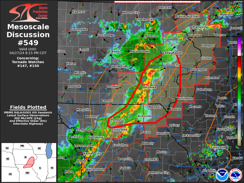
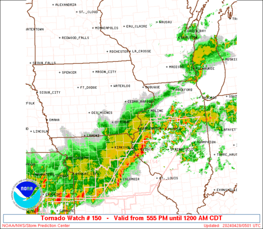
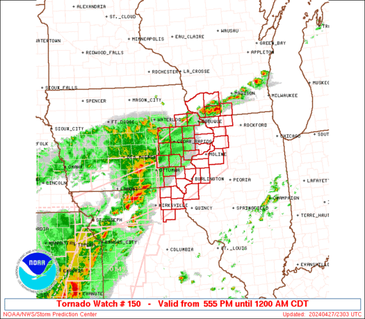
Tornado Watch Number 150
NWS Storm Prediction Center Norman OK
555 PM CDT Sat Apr 27 2024
The NWS Storm Prediction Center has issued a
* Tornado Watch for portions of
Eastern Iowa
Northwest Illinois
Northeast Missouri
Southwest Wisconsin
* Effective this Saturday afternoon from 555 PM until Midnight
CDT.
* Primary threats include...
A couple tornadoes possible
Scattered damaging wind gusts to 70 mph likely
Scattered large hail and isolated very large hail events to 2
inches in diameter possible
SUMMARY...Thunderstorms will gradually develop this evening and
spread into the Watch area. Large hail, damaging gusts, and a few
tornadoes are possible with the stronger supercells and embedded
thunderstorm clusters.
The tornado watch area is approximately along and 75 statute miles
north and south of a line from 65 miles west of Burlington IA to 55
miles east southeast of Dubuque IA. For a complete depiction of the
watch see the associated watch outline update (WOUS64 KWNS WOU0).
PRECAUTIONARY/PREPAREDNESS ACTIONS...
REMEMBER...A Tornado Watch means conditions are favorable for
tornadoes and severe thunderstorms in and close to the watch
area. Persons in these areas should be on the lookout for
threatening weather conditions and listen for later statements
and possible warnings.
&&
OTHER WATCH INFORMATION...CONTINUE...WW 145...WW 146...WW
147...WW 148...WW 149...
AVIATION...Tornadoes and a few severe thunderstorms with hail
surface and aloft to 2 inches. Extreme turbulence and surface wind
gusts to 60 knots. A few cumulonimbi with maximum tops to 500. Mean
storm motion vector 24035.
...Smith
   SEL0

   URGENT - IMMEDIATE BROADCAST REQUESTED
   Tornado Watch Number 150
   NWS Storm Prediction Center Norman OK
   555 PM CDT Sat Apr 27 2024

   The NWS Storm Prediction Center has issued a

   * Tornado Watch for portions of
     Eastern Iowa
     Northwest Illinois
     Northeast Missouri
     Southwest Wisconsin

   * Effective this Saturday afternoon from 555 PM until Midnight
     CDT.

   * Primary threats include...
     A couple tornadoes possible
     Scattered damaging wind gusts to 70 mph likely
     Scattered large hail and isolated very large hail events to 2
       inches in diameter possible

   SUMMARY...Thunderstorms will gradually develop this evening and
   spread into the Watch area.  Large hail, damaging gusts, and a few
   tornadoes are possible with the stronger supercells and embedded
   thunderstorm clusters.

   The tornado watch area is approximately along and 75 statute miles
   north and south of a line from 65 miles west of Burlington IA to 55
   miles east southeast of Dubuque IA. For a complete depiction of the
   watch see the associated watch outline update (WOUS64 KWNS WOU0).

   PRECAUTIONARY/PREPAREDNESS ACTIONS...

   REMEMBER...A Tornado Watch means conditions are favorable for
   tornadoes and severe thunderstorms in and close to the watch
   area. Persons in these areas should be on the lookout for
   threatening weather conditions and listen for later statements
   and possible warnings.

   &&

   OTHER WATCH INFORMATION...CONTINUE...WW 145...WW 146...WW
   147...WW 148...WW 149...

   AVIATION...Tornadoes and a few severe thunderstorms with hail
   surface and aloft to 2 inches. Extreme turbulence and surface wind
   gusts to 60 knots. A few cumulonimbi with maximum tops to 500. Mean
   storm motion vector 24035.

   ...Smith
 Note:
The Aviation Watch (SAW) product is an approximation to the watch area.
The actual watch is depicted by the shaded areas.
Note:
The Aviation Watch (SAW) product is an approximation to the watch area.
The actual watch is depicted by the shaded areas.
SAW0
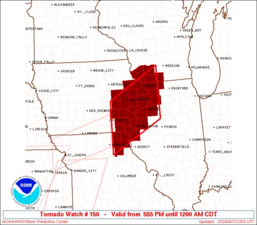
WW 150 TORNADO IA IL MO WI 272255Z - 280500Z
AXIS..75 STATUTE MILES NORTH AND SOUTH OF LINE..
65W BRL/BURLINGTON IA/ - 55ESE DBQ/DUBUQUE IA/
..AVIATION COORDS.. 65NM N/S /39NNE IRK - 47ESE DBQ/
HAIL SURFACE AND ALOFT..2 INCHES. WIND GUSTS..60 KNOTS.
MAX TOPS TO 500. MEAN STORM MOTION VECTOR 24035.
LAT...LON 41869237 43188973 41018973 39689237
THIS IS AN APPROXIMATION TO THE WATCH AREA. FOR A
COMPLETE DEPICTION OF THE WATCH SEE WOUS64 KWNS
FOR WOU0.
Watch 150 Status Report Messages:
STATUS REPORT #4 ON WW 150

VALID 280250Z - 280340Z

SEVERE WEATHER THREAT CONTINUES RIGHT OF A LINE FROM 10 N IRK TO
45 WSW BRL TO 20 NW BRL TO 15 NNW MLI TO 35 SE DBQ TO 20 WNW MSN.

..THORNTON..04/28/24

ATTN...WFO...DVN...LSX...ARX...MKX...

&&

STATUS REPORT FOR WT 150

SEVERE WEATHER THREAT CONTINUES FOR THE FOLLOWING AREAS

ILC011-015-067-071-073-109-131-155-177-187-195-280340-

IL
.    ILLINOIS COUNTIES INCLUDED ARE

BUREAU		     CARROLL		 HANCOCK
HENDERSON	     HENRY		 MCDONOUGH
MERCER		     PUTNAM		 STEPHENSON
WARREN		     WHITESIDE
$$


IAC057-111-280340-

IA
.    IOWA COUNTIES INCLUDED ARE

DES MOINES	     LEE
$$


MOC045-103-111-205-280340-

MO
.    MISSOURI COUNTIES INCLUDED ARE

CLARK		     KNOX		 LEWIS
SHELBY
$$


WIC045-280340-

WI
.    WISCONSIN COUNTIES INCLUDED ARE

GREEN
$$


THE WATCH STATUS MESSAGE IS FOR GUIDANCE PURPOSES ONLY.  PLEASE
REFER TO WATCH COUNTY NOTIFICATION STATEMENTS FOR OFFICIAL
INFORMATION ON COUNTIES...INDEPENDENT CITIES AND MARINE ZONES
CLEARED FROM SEVERE THUNDERSTORM AND TORNADO WATCHES.
$$

STATUS REPORT #3 ON WW 150

VALID 280150Z - 280240Z

SEVERE WEATHER THREAT CONTINUES RIGHT OF A LINE FROM 25 N IRK TO
30 NNW BRL TO 30 NW MLI TO 25 SW LNR.

..THORNTON..04/28/24

ATTN...WFO...DVN...LSX...ARX...MKX...

&&

STATUS REPORT FOR WT 150

SEVERE WEATHER THREAT CONTINUES FOR THE FOLLOWING AREAS

ILC015-067-071-073-085-131-161-177-187-195-280240-

IL
.    ILLINOIS COUNTIES INCLUDED ARE

CARROLL 	     HANCOCK		 HENDERSON
HENRY		     JO DAVIESS 	 MERCER
ROCK ISLAND	     STEPHENSON 	 WARREN
WHITESIDE
$$


IAC045-057-087-097-111-163-280240-

IA
.    IOWA COUNTIES INCLUDED ARE

CLINTON 	     DES MOINES 	 HENRY
JACKSON 	     LEE		 SCOTT
$$


MOC045-103-111-199-205-280240-

MO
.    MISSOURI COUNTIES INCLUDED ARE

CLARK		     KNOX		 LEWIS
SCOTLAND	     SHELBY
$$


WIC045-049-065-280240-

WI
.    WISCONSIN COUNTIES INCLUDED ARE

GREEN		     IOWA		 LAFAYETTE
$$


THE WATCH STATUS MESSAGE IS FOR GUIDANCE PURPOSES ONLY.  PLEASE
REFER TO WATCH COUNTY NOTIFICATION STATEMENTS FOR OFFICIAL
INFORMATION ON COUNTIES...INDEPENDENT CITIES AND MARINE ZONES
CLEARED FROM SEVERE THUNDERSTORM AND TORNADO WATCHES.
$$

STATUS REPORT #2 ON WW 150

VALID 280030Z - 280140Z

THE SEVERE WEATHER THREAT CONTINUES ACROSS THE ENTIRE WATCH AREA.

..WENDT..04/28/24

ATTN...WFO...DVN...LSX...ARX...MKX...

&&

STATUS REPORT FOR WT 150

SEVERE WEATHER THREAT CONTINUES FOR THE FOLLOWING AREAS

ILC015-067-071-073-085-131-161-177-187-195-280140-

IL
.    ILLINOIS COUNTIES INCLUDED ARE

CARROLL 	     HANCOCK		 HENDERSON
HENRY		     JO DAVIESS 	 MERCER
ROCK ISLAND	     STEPHENSON 	 WARREN
WHITESIDE
$$


IAC011-031-045-055-057-061-087-095-097-101-103-105-107-111-113-
115-139-163-177-183-280140-

IA
.    IOWA COUNTIES INCLUDED ARE

BENTON		     CEDAR		 CLINTON
DELAWARE	     DES MOINES 	 DUBUQUE
HENRY		     IOWA		 JACKSON
JEFFERSON	     JOHNSON		 JONES
KEOKUK		     LEE		 LINN
LOUISA		     MUSCATINE		 SCOTT
VAN BUREN	     WASHINGTON
$$


MOC045-103-111-199-205-280140-

MO
.    MISSOURI COUNTIES INCLUDED ARE

CLARK		     KNOX		 LEWIS
SCOTLAND	     SHELBY
$$


WIC043-045-049-065-280140-

WI
.    WISCONSIN COUNTIES INCLUDED ARE

GRANT		     GREEN		 IOWA
LAFAYETTE
$$


THE WATCH STATUS MESSAGE IS FOR GUIDANCE PURPOSES ONLY.  PLEASE
REFER TO WATCH COUNTY NOTIFICATION STATEMENTS FOR OFFICIAL
INFORMATION ON COUNTIES...INDEPENDENT CITIES AND MARINE ZONES
CLEARED FROM SEVERE THUNDERSTORM AND TORNADO WATCHES.
$$

STATUS REPORT #1 ON WW 150

VALID 272355Z - 280040Z

THE SEVERE WEATHER THREAT CONTINUES ACROSS THE ENTIRE WATCH AREA.

..WENDT..04/27/24

ATTN...WFO...DVN...LSX...ARX...MKX...

&&

STATUS REPORT FOR WT 150

SEVERE WEATHER THREAT CONTINUES FOR THE FOLLOWING AREAS

ILC015-067-071-073-085-131-161-177-187-195-280040-

IL
.    ILLINOIS COUNTIES INCLUDED ARE

CARROLL 	     HANCOCK		 HENDERSON
HENRY		     JO DAVIESS 	 MERCER
ROCK ISLAND	     STEPHENSON 	 WARREN
WHITESIDE
$$


IAC011-031-045-055-057-061-087-095-097-101-103-105-107-111-113-
115-139-163-177-183-280040-

IA
.    IOWA COUNTIES INCLUDED ARE

BENTON		     CEDAR		 CLINTON
DELAWARE	     DES MOINES 	 DUBUQUE
HENRY		     IOWA		 JACKSON
JEFFERSON	     JOHNSON		 JONES
KEOKUK		     LEE		 LINN
LOUISA		     MUSCATINE		 SCOTT
VAN BUREN	     WASHINGTON
$$


MOC045-103-111-199-205-280040-

MO
.    MISSOURI COUNTIES INCLUDED ARE

CLARK		     KNOX		 LEWIS
SCOTLAND	     SHELBY
$$


WIC043-045-049-065-280040-

WI
.    WISCONSIN COUNTIES INCLUDED ARE

GRANT		     GREEN		 IOWA
LAFAYETTE
$$


THE WATCH STATUS MESSAGE IS FOR GUIDANCE PURPOSES ONLY.  PLEASE
REFER TO WATCH COUNTY NOTIFICATION STATEMENTS FOR OFFICIAL
INFORMATION ON COUNTIES...INDEPENDENT CITIES AND MARINE ZONES
CLEARED FROM SEVERE THUNDERSTORM AND TORNADO WATCHES.
$$
Note:
Click for Complete Product Text.
Tornadoes
Probability of 2 or more tornadoes
|
Mod (40%)
|
Probability of 1 or more strong (EF2-EF5) tornadoes
|
Low (20%)
|
Wind
Probability of 10 or more severe wind events
|
Mod (60%)
|
Probability of 1 or more wind events > 65 knots
|
Low (10%)
|
Hail
Probability of 10 or more severe hail events
|
Mod (50%)
|
Probability of 1 or more hailstones > 2 inches
|
Mod (30%)
|
Combined Severe Hail/Wind
Probability of 6 or more combined severe hail/wind events
|
High (90%)
|
For each watch, probabilities for particular events inside the watch
(listed above in each table) are determined by the issuing forecaster.
The "Low" category contains probability values ranging from less than 2%
to 20% (EF2-EF5 tornadoes), less than 5% to 20% (all other probabilities),
"Moderate" from 30% to 60%, and "High" from 70% to greater than 95%.
High values are bolded and lighter in color to provide awareness of
an increased threat for a particular event.


 @NWSSPC