 Note:
The expiration time in the watch graphic is amended if the watch is
replaced, cancelled or extended.
Note:
Note:
The expiration time in the watch graphic is amended if the watch is
replaced, cancelled or extended.
Note: Click for
Watch Status Reports.
SEL2
URGENT - IMMEDIATE BROADCAST REQUESTED
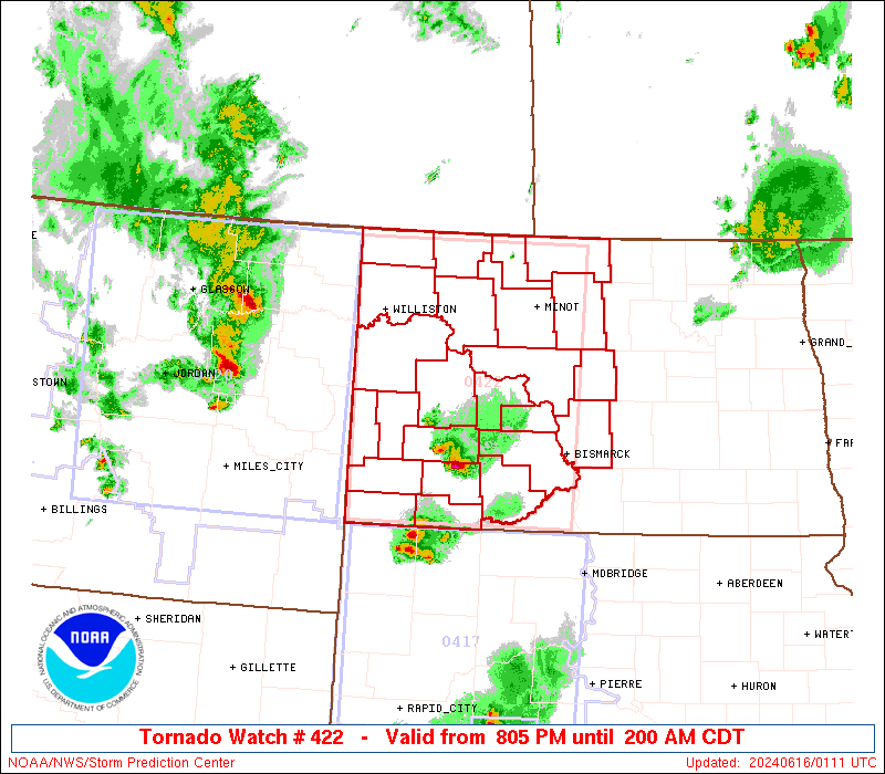
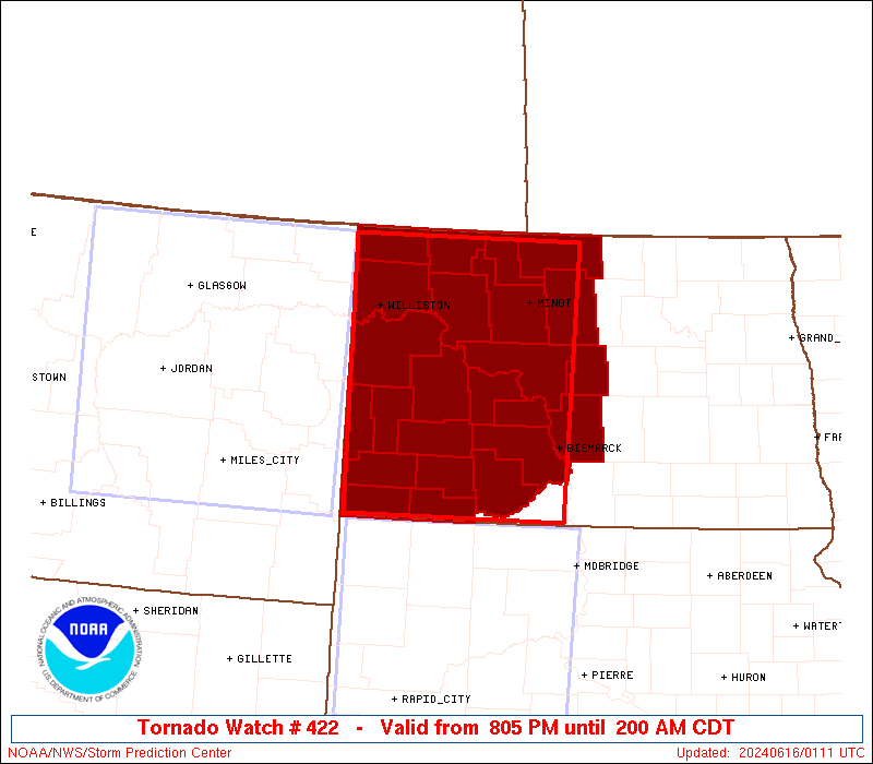
Tornado Watch Number 422
NWS Storm Prediction Center Norman OK
805 PM CDT Sat Jun 15 2024
The NWS Storm Prediction Center has issued a
* Tornado Watch for portions of
Western and Central North Dakota
* Effective this Saturday night and Sunday morning from 805 PM
until 200 AM CDT.
* Primary threats include...
A couple tornadoes possible
Scattered damaging winds and isolated significant gusts to 85
mph likely
Scattered large hail and isolated very large hail events to 2
inches in diameter possible
SUMMARY...A couple of isolated severe thunderstorms are possible
early this evening. Large to very large hail and a tornado are
possible with this activity. A band of severe thunderstorms is
forecast to move from west to east from western into central
portions of North Dakota later this evening into tonight. Severe
gusts (60-85 mph) will be the primary hazard with the stronger
outflow surges.
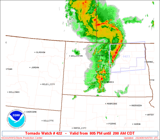
The tornado watch area is approximately along and 80 statute miles
east and west of a line from 65 miles northwest of Minot ND to 60
miles south southeast of Dickinson ND. For a complete depiction of
the watch see the associated watch outline update (WOUS64 KWNS
WOU2).
PRECAUTIONARY/PREPAREDNESS ACTIONS...
REMEMBER...A Tornado Watch means conditions are favorable for
tornadoes and severe thunderstorms in and close to the watch
area. Persons in these areas should be on the lookout for
threatening weather conditions and listen for later statements
and possible warnings.
&&
OTHER WATCH INFORMATION...CONTINUE...WW 417...WW 418...WW
419...WW 420...WW 421...
AVIATION...Tornadoes and a few severe thunderstorms with hail
surface and aloft to 2 inches. Extreme turbulence and surface wind
gusts to 75 knots. A few cumulonimbi with maximum tops to 500. Mean
storm motion vector 26040.
...Smith
 Note:
The Aviation Watch (SAW) product is an approximation to the watch area.
The actual watch is depicted by the shaded areas.
Note:
The Aviation Watch (SAW) product is an approximation to the watch area.
The actual watch is depicted by the shaded areas.
   SAW2
   WW 422 TORNADO ND 160105Z - 160700Z
   AXIS..80 STATUTE MILES EAST AND WEST OF LINE..
   65NW MOT/MINOT ND/ - 60SSE DIK/DICKINSON ND/
   ..AVIATION COORDS.. 70NM E/W /57NW MOT - 55SSE DIK/
   HAIL SURFACE AND ALOFT..2 INCHES. WIND GUSTS..75 KNOTS.
   MAX TOPS TO 500. MEAN STORM MOTION VECTOR 26040.

   LAT...LON 48920053 45980066 45980399 48920405

   THIS IS AN APPROXIMATION TO THE WATCH AREA.  FOR A
   COMPLETE DEPICTION OF THE WATCH SEE WOUS64 KWNS
   FOR WOU2.
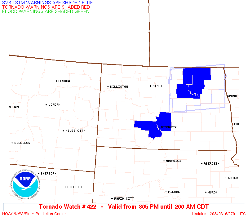
Watch 422 Status Report Messages:
STATUS REPORT #4 ON WW 422
VALID 160525Z - 160640Z
SEVERE WEATHER THREAT CONTINUES RIGHT OF A LINE FROM 35 NE 2WX TO
30 NE DIK TO 35 WNW MOT TO 65 NNW MOT.
..LEITMAN..06/16/24
ATTN...WFO...BIS...
&&
STATUS REPORT FOR WT 422
SEVERE WEATHER THREAT CONTINUES FOR THE FOLLOWING AREAS
NDC001-009-015-037-041-049-055-057-059-065-075-083-101-160640-
ND
. NORTH DAKOTA COUNTIES INCLUDED ARE
ADAMS BOTTINEAU BURLEIGH
GRANT HETTINGER MCHENRY
MCLEAN MERCER MORTON
OLIVER RENVILLE SHERIDAN
WARD
$$
THE WATCH STATUS MESSAGE IS FOR GUIDANCE PURPOSES ONLY. PLEASE
REFER TO WATCH COUNTY NOTIFICATION STATEMENTS FOR OFFICIAL
INFORMATION ON COUNTIES...INDEPENDENT CITIES AND MARINE ZONES
CLEARED FROM SEVERE THUNDERSTORM AND TORNADO WATCHES.
$$
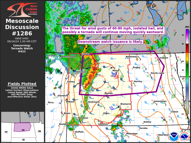
STATUS REPORT #3 ON WW 422
VALID 160440Z - 160540Z
SEVERE WEATHER THREAT CONTINUES RIGHT OF A LINE FROM 20 SSW BHK
TO 30 SW DIK TO 35 SE ISN TO 45 ENE ISN TO 70 NNE ISN.
FOR ADDITIONAL INFORMATION SEE MESOSCALE DISCUSSION 1286
..DEAN..06/16/24
ATTN...WFO...BIS...
&&
STATUS REPORT FOR WT 422
SEVERE WEATHER THREAT CONTINUES FOR THE FOLLOWING AREAS
NDC001-009-011-013-015-025-037-041-049-053-055-057-059-061-065-
075-083-087-089-101-160540-
ND
. NORTH DAKOTA COUNTIES INCLUDED ARE
ADAMS BOTTINEAU BOWMAN
BURKE BURLEIGH DUNN
GRANT HETTINGER MCHENRY
MCKENZIE MCLEAN MERCER
MORTON MOUNTRAIL OLIVER
RENVILLE SHERIDAN SLOPE
STARK WARD
$$
THE WATCH STATUS MESSAGE IS FOR GUIDANCE PURPOSES ONLY. PLEASE
REFER TO WATCH COUNTY NOTIFICATION STATEMENTS FOR OFFICIAL
INFORMATION ON COUNTIES...INDEPENDENT CITIES AND MARINE ZONES
CLEARED FROM SEVERE THUNDERSTORM AND TORNADO WATCHES.
$$
STATUS REPORT #2 ON WW 422
VALID 160350Z - 160440Z
THE SEVERE WEATHER THREAT CONTINUES ACROSS THE ENTIRE WATCH AREA.
FOR ADDITIONAL INFORMATION SEE MESOSCALE DISCUSSION 1284
..THORNTON..06/16/24
ATTN...WFO...BIS...
&&
STATUS REPORT FOR WT 422
SEVERE WEATHER THREAT CONTINUES FOR THE FOLLOWING AREAS
NDC001-007-009-011-013-015-023-025-033-037-041-049-053-055-057-
059-061-065-075-083-087-089-101-105-160440-
ND
. NORTH DAKOTA COUNTIES INCLUDED ARE
ADAMS BILLINGS BOTTINEAU
BOWMAN BURKE BURLEIGH
DIVIDE DUNN GOLDEN VALLEY
GRANT HETTINGER MCHENRY
MCKENZIE MCLEAN MERCER
MORTON MOUNTRAIL OLIVER
RENVILLE SHERIDAN SLOPE
STARK WARD WILLIAMS
$$
THE WATCH STATUS MESSAGE IS FOR GUIDANCE PURPOSES ONLY. PLEASE
REFER TO WATCH COUNTY NOTIFICATION STATEMENTS FOR OFFICIAL
INFORMATION ON COUNTIES...INDEPENDENT CITIES AND MARINE ZONES
CLEARED FROM SEVERE THUNDERSTORM AND TORNADO WATCHES.
$$
STATUS REPORT #1 ON WW 422
VALID 160235Z - 160340Z
THE SEVERE WEATHER THREAT CONTINUES ACROSS THE ENTIRE WATCH AREA.
..THORNTON..06/16/24
ATTN...WFO...BIS...
&&
STATUS REPORT FOR WT 422
SEVERE WEATHER THREAT CONTINUES FOR THE FOLLOWING AREAS
NDC001-007-009-011-013-015-023-025-033-037-041-049-053-055-057-
059-061-065-075-083-087-089-101-105-160340-
ND
. NORTH DAKOTA COUNTIES INCLUDED ARE
ADAMS BILLINGS BOTTINEAU
BOWMAN BURKE BURLEIGH
DIVIDE DUNN GOLDEN VALLEY
GRANT HETTINGER MCHENRY
MCKENZIE MCLEAN MERCER
MORTON MOUNTRAIL OLIVER
RENVILLE SHERIDAN SLOPE
STARK WARD WILLIAMS
$$
THE WATCH STATUS MESSAGE IS FOR GUIDANCE PURPOSES ONLY. PLEASE
REFER TO WATCH COUNTY NOTIFICATION STATEMENTS FOR OFFICIAL
INFORMATION ON COUNTIES...INDEPENDENT CITIES AND MARINE ZONES
CLEARED FROM SEVERE THUNDERSTORM AND TORNADO WATCHES.
$$
Note:
Click for Complete Product Text.
Tornadoes
Probability of 2 or more tornadoes
|
Mod (30%)
|
Probability of 1 or more strong (EF2-EF5) tornadoes
|
Low (10%)
|
Wind
Probability of 10 or more severe wind events
|
Mod (60%)
|
Probability of 1 or more wind events > 65 knots
|
Mod (60%)
|
Hail
Probability of 10 or more severe hail events
|
Mod (40%)
|
Probability of 1 or more hailstones > 2 inches
|
Mod (40%)
|
Combined Severe Hail/Wind
Probability of 6 or more combined severe hail/wind events
|
High (90%)
|
For each watch, probabilities for particular events inside the watch
(listed above in each table) are determined by the issuing forecaster.
The "Low" category contains probability values ranging from less than 2%
to 20% (EF2-EF5 tornadoes), less than 5% to 20% (all other probabilities),
"Moderate" from 30% to 60%, and "High" from 70% to greater than 95%.
High values are bolded and lighter in color to provide awareness of
an increased threat for a particular event.


 @NWSSPC