 Note:
The expiration time in the watch graphic is amended if the watch is
replaced, cancelled or extended.
Note:
Note:
The expiration time in the watch graphic is amended if the watch is
replaced, cancelled or extended.
Note: Click for
Watch Status Reports.
SEL3
URGENT - IMMEDIATE BROADCAST REQUESTED
Severe Thunderstorm Watch Number 423
NWS Storm Prediction Center Norman OK
1200 AM CDT Sun Jun 16 2024
The NWS Storm Prediction Center has issued a
* Severe Thunderstorm Watch for portions of
Northern and Northeast North Dakota
* Effective this Sunday morning from Midnight until 600 AM CDT.
* Primary threats include...
Scattered damaging winds and isolated significant gusts to 80
mph possible
Isolated large hail events to 1 inch in diameter possible
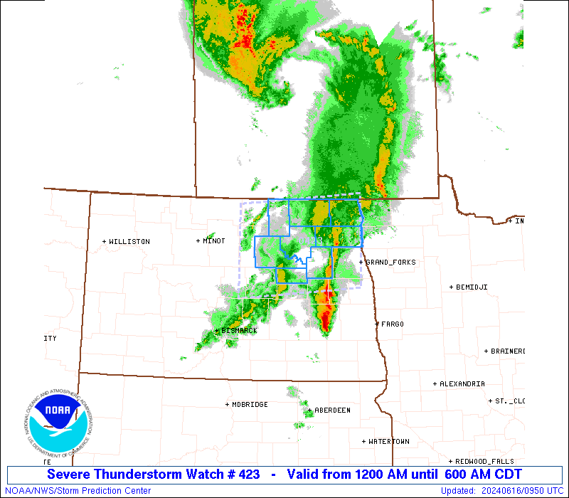
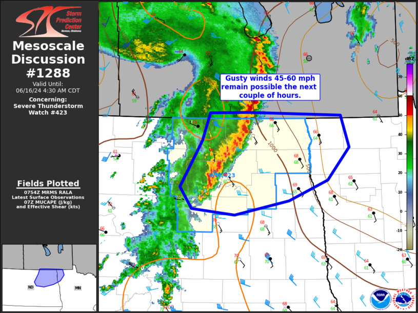
SUMMARY...A severe squall line will likely continue east across
northern and into northeast North Dakota tonight. Severe gusts
(60-80 mph) will be the primary risk with the stronger surges and
embedded bowing segments within the thunderstorm band.
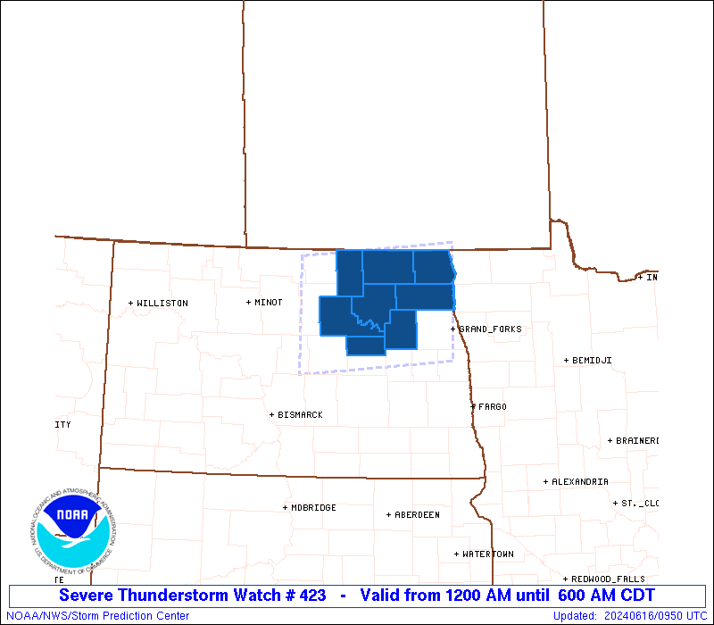
The severe thunderstorm watch area is approximately along and 55
statute miles north and south of a line from 60 miles west of Devils
Lake ND to 25 miles north of Grand Forks ND. For a complete
depiction of the watch see the associated watch outline update
(WOUS64 KWNS WOU3).
PRECAUTIONARY/PREPAREDNESS ACTIONS...
REMEMBER...A Severe Thunderstorm Watch means conditions are
favorable for severe thunderstorms in and close to the watch area.
Persons in these areas should be on the lookout for threatening
weather conditions and listen for later statements and possible
warnings. Severe thunderstorms can and occasionally do produce
tornadoes.
&&
OTHER WATCH INFORMATION...CONTINUE...WW 421...WW 422...
AVIATION...A few severe thunderstorms with hail surface and aloft to
1 inch. Extreme turbulence and surface wind gusts to 70 knots. A few
cumulonimbi with maximum tops to 500. Mean storm motion vector
26045.
...Smith
 Note:
The Aviation Watch (SAW) product is an approximation to the watch area.
The actual watch is depicted by the shaded areas.
Note:
The Aviation Watch (SAW) product is an approximation to the watch area.
The actual watch is depicted by the shaded areas.
SAW3
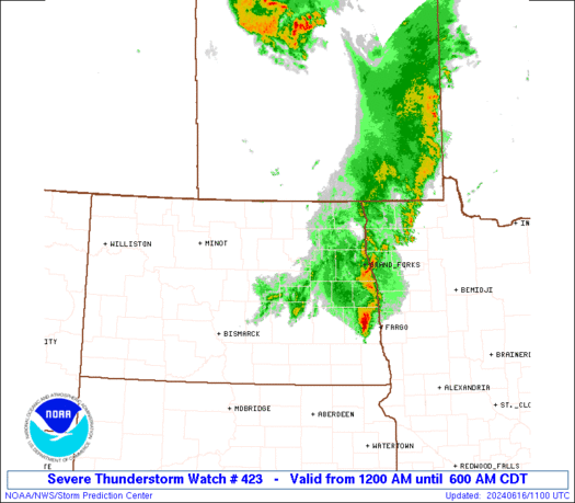
WW 423 SEVERE TSTM ND 160500Z - 161100Z
AXIS..55 STATUTE MILES NORTH AND SOUTH OF LINE..
60W DVL/DEVILS LAKE ND/ - 25N GFK/GRAND FORKS ND/
..AVIATION COORDS.. 50NM N/S /44ESE MOT - 22N GFK/
HAIL SURFACE AND ALOFT..1 INCH. WIND GUSTS..70 KNOTS.
MAX TOPS TO 500. MEAN STORM MOTION VECTOR 26045.
LAT...LON 48910022 49119718 47529718 47320022
THIS IS AN APPROXIMATION TO THE WATCH AREA. FOR A
COMPLETE DEPICTION OF THE WATCH SEE WOUS64 KWNS
FOR WOU3.
Watch 423 Status Report Messages:
STATUS REPORT #4 ON WW 423

VALID 160935Z - 161040Z

SEVERE WEATHER THREAT CONTINUES RIGHT OF A LINE FROM 30 NNE JMS
TO 30 ENE DVL TO 30 NNW HCO.

..LEITMAN..06/16/24

ATTN...WFO...FGF...BIS...

&&

STATUS REPORT FOR WS 423

SEVERE WEATHER THREAT CONTINUES FOR THE FOLLOWING AREAS

NDC063-067-099-161040-

ND
.    NORTH DAKOTA COUNTIES INCLUDED ARE

NELSON		     PEMBINA		 WALSH
$$


THE WATCH STATUS MESSAGE IS FOR GUIDANCE PURPOSES ONLY.  PLEASE
REFER TO WATCH COUNTY NOTIFICATION STATEMENTS FOR OFFICIAL
INFORMATION ON COUNTIES...INDEPENDENT CITIES AND MARINE ZONES
CLEARED FROM SEVERE THUNDERSTORM AND TORNADO WATCHES.
$$

STATUS REPORT #3 ON WW 423

VALID 160830Z - 160940Z

SEVERE WEATHER THREAT CONTINUES RIGHT OF A LINE FROM 35 NNW JMS
TO 10 NNE DVL TO 55 W HCO TO 60 WNW HCO.

..LEITMAN..06/16/24

ATTN...WFO...FGF...BIS...

&&

STATUS REPORT FOR WS 423

SEVERE WEATHER THREAT CONTINUES FOR THE FOLLOWING AREAS

NDC019-063-067-071-099-160940-

ND
.    NORTH DAKOTA COUNTIES INCLUDED ARE

CAVALIER	     NELSON		 PEMBINA
RAMSEY		     WALSH
$$


THE WATCH STATUS MESSAGE IS FOR GUIDANCE PURPOSES ONLY.  PLEASE
REFER TO WATCH COUNTY NOTIFICATION STATEMENTS FOR OFFICIAL
INFORMATION ON COUNTIES...INDEPENDENT CITIES AND MARINE ZONES
CLEARED FROM SEVERE THUNDERSTORM AND TORNADO WATCHES.
$$

STATUS REPORT #2 ON WW 423

VALID 160735Z - 160840Z

SEVERE WEATHER THREAT CONTINUES RIGHT OF A LINE FROM 50 ESE N60
TO 25 NW DVL TO 70 N DVL.

..LEITMAN..06/16/24

ATTN...WFO...FGF...BIS...

&&

STATUS REPORT FOR WS 423

SEVERE WEATHER THREAT CONTINUES FOR THE FOLLOWING AREAS

NDC005-019-027-063-067-071-095-099-103-160840-

ND
.    NORTH DAKOTA COUNTIES INCLUDED ARE

BENSON		     CAVALIER		 EDDY
NELSON		     PEMBINA		 RAMSEY
TOWNER		     WALSH		 WELLS
$$


THE WATCH STATUS MESSAGE IS FOR GUIDANCE PURPOSES ONLY.  PLEASE
REFER TO WATCH COUNTY NOTIFICATION STATEMENTS FOR OFFICIAL
INFORMATION ON COUNTIES...INDEPENDENT CITIES AND MARINE ZONES
CLEARED FROM SEVERE THUNDERSTORM AND TORNADO WATCHES.
$$

STATUS REPORT #1 ON WW 423

VALID 160630Z - 160740Z

THE SEVERE WEATHER THREAT CONTINUES ACROSS THE ENTIRE WATCH AREA.

..LEITMAN..06/16/24

ATTN...WFO...FGF...BIS...

&&

STATUS REPORT FOR WS 423

SEVERE WEATHER THREAT CONTINUES FOR THE FOLLOWING AREAS

NDC005-019-027-063-067-069-071-079-095-099-103-160740-

ND
.    NORTH DAKOTA COUNTIES INCLUDED ARE

BENSON		     CAVALIER		 EDDY
NELSON		     PEMBINA		 PIERCE
RAMSEY		     ROLETTE		 TOWNER
WALSH		     WELLS
$$


THE WATCH STATUS MESSAGE IS FOR GUIDANCE PURPOSES ONLY.  PLEASE
REFER TO WATCH COUNTY NOTIFICATION STATEMENTS FOR OFFICIAL
INFORMATION ON COUNTIES...INDEPENDENT CITIES AND MARINE ZONES
CLEARED FROM SEVERE THUNDERSTORM AND TORNADO WATCHES.
$$
Note:
Click for Complete Product Text.
Tornadoes
Probability of 2 or more tornadoes
|
Low (10%)
|
Probability of 1 or more strong (EF2-EF5) tornadoes
|
Low (<2%)
|
Wind
Probability of 10 or more severe wind events
|
Mod (40%)
|
Probability of 1 or more wind events > 65 knots
|
Mod (30%)
|
Hail
Probability of 10 or more severe hail events
|
Low (20%)
|
Probability of 1 or more hailstones > 2 inches
|
Low (10%)
|
Combined Severe Hail/Wind
Probability of 6 or more combined severe hail/wind events
|
Mod (60%)
|
For each watch, probabilities for particular events inside the watch
(listed above in each table) are determined by the issuing forecaster.
The "Low" category contains probability values ranging from less than 2%
to 20% (EF2-EF5 tornadoes), less than 5% to 20% (all other probabilities),
"Moderate" from 30% to 60%, and "High" from 70% to greater than 95%.
High values are bolded and lighter in color to provide awareness of
an increased threat for a particular event.


 @NWSSPC