|
| Mesoscale Discussion 1286 |
|
< Previous MD Next MD >
|
|
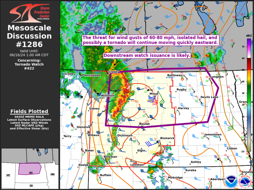
   Mesoscale Discussion 1286
   NWS Storm Prediction Center Norman OK
   1131 PM CDT Sat Jun 15 2024

   Areas affected...northern ND

   Concerning...Tornado Watch 422...

   Valid 160431Z - 160600Z

   The severe weather threat for Tornado Watch 422 continues.

   SUMMARY...The threat for 60-80 mph wind gusts, isolated hail, and
   possibly a tornado will spread quickly eastward into the early
   overnight. Downstream watch issuance is likely.

   DISCUSSION...A fast-moving MCS with a history of producing
   significant severe gusts is moving across northwest ND late this
   evening. This MCS remains quite well-organized, with evidence of a
   strong rear-inflow jet, and 2-hour pressure rises of greater than 6
   mb recently noted over northeast MT. Steep midlevel lapse rates,
   relatively rich low-level moisture, and favorable deep-layer shear
   will support maintenance of this MCS as it moves across northern ND
   into the early overnight hours. Wind gusts of 60-80 mph will
   continue to be the primary hazard, though favorable low-level
   shear/SRH (as noted on the KMIB VWP) could also support potential
   for a line-embedded tornado.

   With some severe-wind risk expected to spread east of WW 422,
   eventual downstream watch issuance into parts of north-central and
   northeast ND is likely.

   ..Dean/Smith.. 06/16/2024

   ...Please see www.spc.noaa.gov for graphic product...

   ATTN...WFO...FGF...BIS...

   LAT...LON   48950316 49030196 49090061 49119857 48469795 47379850
               47220158 47250332 48240322 48950316
|
|
Top/All Mesoscale Discussions/Forecast Products/Home
|
|


 @NWSSPC