Note:
The expiration time in the watch graphic is amended if the watch is
replaced, cancelled or extended.
Note:
Note:
The expiration time in the watch graphic is amended if the watch is
replaced, cancelled or extended.
Note: Click for
Watch Status Reports.
SEL8
URGENT - IMMEDIATE BROADCAST REQUESTED
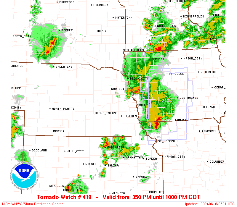
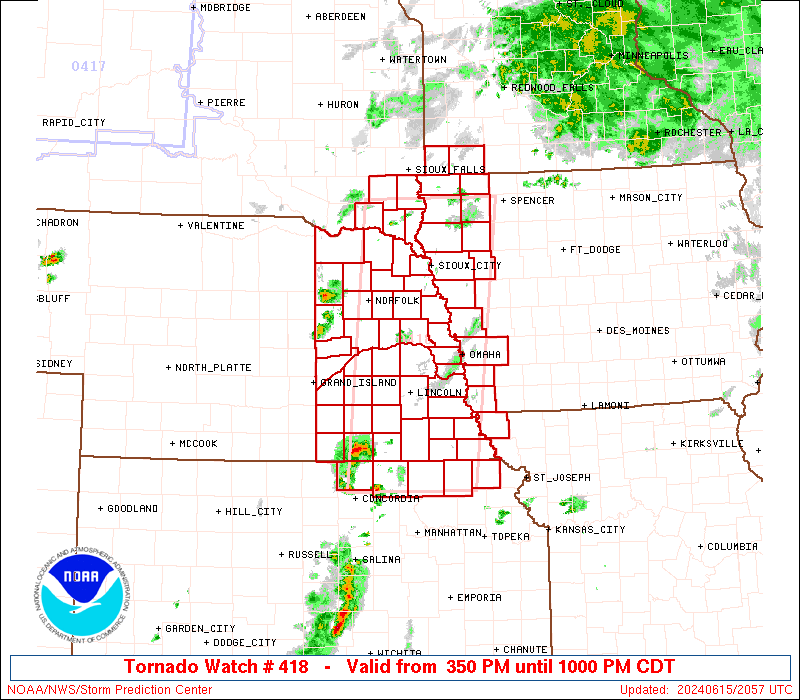
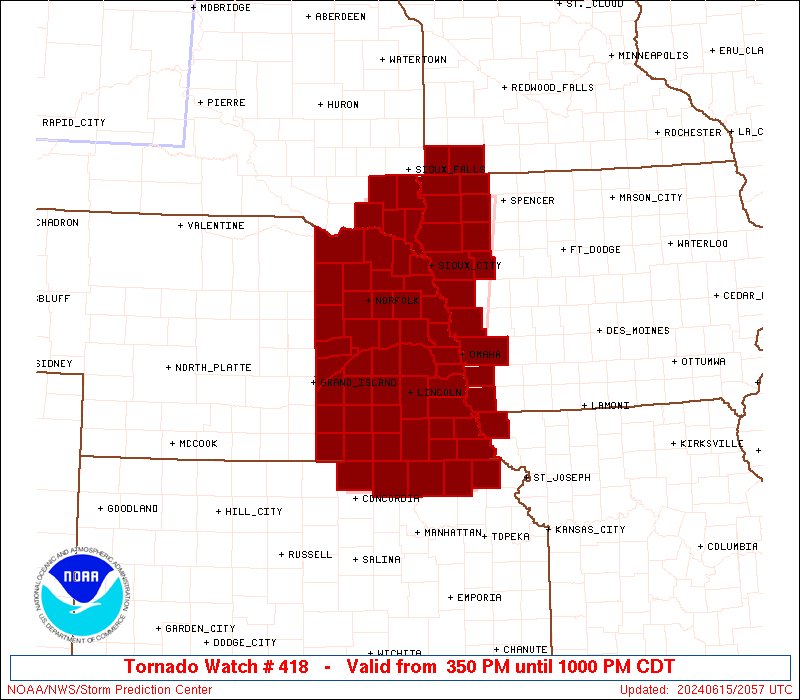
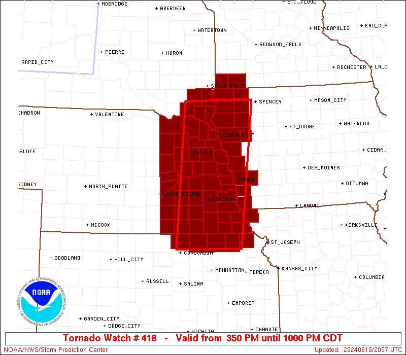
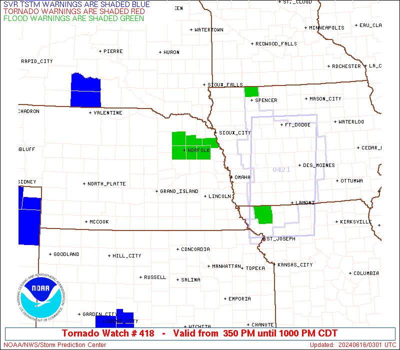
Tornado Watch Number 418
NWS Storm Prediction Center Norman OK
350 PM CDT Sat Jun 15 2024
The NWS Storm Prediction Center has issued a
* Tornado Watch for portions of
Western Iowa
Northeast Kansas
Far Southwest Minnesota
Extreme Northwest Missouri
Eastern Nebraska
Southeast South Dakota
* Effective this Saturday afternoon and evening from 350 PM until
1000 PM CDT.
* Primary threats include...
A few tornadoes and a couple intense tornadoes possible
Scattered large hail and isolated very large hail events to 2
inches in diameter possible
Scattered damaging wind gusts to 70 mph possible
SUMMARY...Thunderstorms will continue to develop and pose a threat
for a few tornadoes, large hail, and damaging winds this afternoon
and evening as they spread east-northeastward.
The tornado watch area is approximately along and 55 statute miles
east and west of a line from 55 miles east northeast of Yankton SD
to 45 miles south of Beatrice NE. For a complete depiction of the
watch see the associated watch outline update (WOUS64 KWNS WOU8).
PRECAUTIONARY/PREPAREDNESS ACTIONS...
REMEMBER...A Tornado Watch means conditions are favorable for
tornadoes and severe thunderstorms in and close to the watch
area. Persons in these areas should be on the lookout for
threatening weather conditions and listen for later statements
and possible warnings.
&&
OTHER WATCH INFORMATION...CONTINUE...WW 417...
AVIATION...Tornadoes and a few severe thunderstorms with hail
surface and aloft to 2 inches. Extreme turbulence and surface wind
gusts to 60 knots. A few cumulonimbi with maximum tops to 550. Mean
storm motion vector 25030.
...Gleason

   SEL8

   URGENT - IMMEDIATE BROADCAST REQUESTED
   Tornado Watch Number 418
   NWS Storm Prediction Center Norman OK
   350 PM CDT Sat Jun 15 2024

   The NWS Storm Prediction Center has issued a

   * Tornado Watch for portions of
     Western Iowa
     Northeast Kansas
     Far Southwest Minnesota
     Extreme Northwest Missouri
     Eastern Nebraska
     Southeast South Dakota

   * Effective this Saturday afternoon and evening from 350 PM until
     1000 PM CDT.

   * Primary threats include...
     A few tornadoes and a couple intense tornadoes possible
     Scattered large hail and isolated very large hail events to 2
       inches in diameter possible
     Scattered damaging wind gusts to 70 mph possible

   SUMMARY...Thunderstorms will continue to develop and pose a threat
   for a few tornadoes, large hail, and damaging winds this afternoon
   and evening as they spread east-northeastward.

   The tornado watch area is approximately along and 55 statute miles
   east and west of a line from 55 miles east northeast of Yankton SD
   to 45 miles south of Beatrice NE. For a complete depiction of the
   watch see the associated watch outline update (WOUS64 KWNS WOU8).

   PRECAUTIONARY/PREPAREDNESS ACTIONS...

   REMEMBER...A Tornado Watch means conditions are favorable for
   tornadoes and severe thunderstorms in and close to the watch
   area. Persons in these areas should be on the lookout for
   threatening weather conditions and listen for later statements
   and possible warnings.

   &&

   OTHER WATCH INFORMATION...CONTINUE...WW 417...

   AVIATION...Tornadoes and a few severe thunderstorms with hail
   surface and aloft to 2 inches. Extreme turbulence and surface wind
   gusts to 60 knots. A few cumulonimbi with maximum tops to 550. Mean
   storm motion vector 25030.

   ...Gleason
 Note:
The Aviation Watch (SAW) product is an approximation to the watch area.
The actual watch is depicted by the shaded areas.
Note:
The Aviation Watch (SAW) product is an approximation to the watch area.
The actual watch is depicted by the shaded areas.
   SAW8
   WW 418 TORNADO IA KS MN MO NE SD 152050Z - 160300Z
   AXIS..55 STATUTE MILES EAST AND WEST OF LINE..
   55ENE YKN/YANKTON SD/ - 45S BIE/BEATRICE NE/
   ..AVIATION COORDS.. 50NM E/W /31SE FSD - 42SW PWE/
   HAIL SURFACE AND ALOFT..2 INCHES. WIND GUSTS..60 KNOTS.
   MAX TOPS TO 550. MEAN STORM MOTION VECTOR 25030.

   LAT...LON 43229528 39639572 39639778 43229746

   THIS IS AN APPROXIMATION TO THE WATCH AREA.  FOR A
   COMPLETE DEPICTION OF THE WATCH SEE WOUS64 KWNS
   FOR WOU8.
Watch 418 Status Report Messages:
STATUS REPORT #4 ON WW 418

VALID 160240Z - 160300Z

SEVERE WEATHER THREAT CONTINUES RIGHT OF A LINE FROM 35 NNW TOP
TO 10 SE SDA TO 20 SW DNS TO 30 W OLU.

WW 418 WILL BE ALLOWED TO EXPIRE AT 160300Z.

..DEAN..06/16/24

ATTN...WFO...FSD...OAX...TOP...EAX...GID...

&&

STATUS REPORT FOR WT 418

SEVERE WEATHER THREAT CONTINUES FOR THE FOLLOWING AREAS

IAC035-085-093-133-141-143-193-160300-

IA
.    IOWA COUNTIES INCLUDED ARE

CHEROKEE	     HARRISON		 IDA
MONONA		     O'BRIEN		 OSCEOLA
WOODBURY
$$


NEC021-037-039-053-119-141-167-177-160300-

NE
.    NEBRASKA COUNTIES INCLUDED ARE

BURT		     COLFAX		 CUMING
DODGE		     MADISON		 PLATTE
STANTON 	     WASHINGTON
$$


THE WATCH STATUS MESSAGE IS FOR GUIDANCE PURPOSES ONLY.  PLEASE
REFER TO WATCH COUNTY NOTIFICATION STATEMENTS FOR OFFICIAL
INFORMATION ON COUNTIES...INDEPENDENT CITIES AND MARINE ZONES
CLEARED FROM SEVERE THUNDERSTORM AND TORNADO WATCHES.
$$

STATUS REPORT #3 ON WW 418

VALID 160100Z - 160240Z

SEVERE WEATHER THREAT CONTINUES RIGHT OF A LINE FROM 30 NW MHK TO
25 WNW OLU TO 30 ENE BUB.

FOR ADDITIONAL INFORMATION SEE MESOSCALE DISCUSSION 1279

..DEAN..06/16/24

ATTN...WFO...FSD...OAX...TOP...EAX...GID...

&&

STATUS REPORT FOR WT 418

SEVERE WEATHER THREAT CONTINUES FOR THE FOLLOWING AREAS

IAC035-071-085-093-119-129-133-141-143-149-155-167-193-160240-

IA
.    IOWA COUNTIES INCLUDED ARE

CHEROKEE	     FREMONT		 HARRISON
IDA		     LYON		 MILLS
MONONA		     O'BRIEN		 OSCEOLA
PLYMOUTH	     POTTAWATTAMIE	 SIOUX
WOODBURY
$$


KSC013-117-131-160240-

KS
.    KANSAS COUNTIES INCLUDED ARE

BROWN		     MARSHALL		 NEMAHA
$$


MNC105-133-160240-

MN
.    MINNESOTA COUNTIES INCLUDED ARE

NOBLES		     ROCK
$$


MOC005-160240-

MO
.    MISSOURI COUNTIES INCLUDED ARE

ATCHISON
$$


NEC021-023-025-027-037-039-043-051-053-055-067-097-109-119-127-
131-133-139-141-147-153-155-167-173-177-179-160240-

NE
.    NEBRASKA COUNTIES INCLUDED ARE

BURT		     BUTLER		 CASS
CEDAR		     COLFAX		 CUMING
DAKOTA		     DIXON		 DODGE
DOUGLAS 	     GAGE		 JOHNSON
LANCASTER	     MADISON		 NEMAHA
OTOE		     PAWNEE		 PIERCE
PLATTE		     RICHARDSON 	 SARPY
SAUNDERS	     STANTON		 THURSTON
WASHINGTON	     WAYNE
$$


SDC027-083-125-127-135-160240-

SD
.    SOUTH DAKOTA COUNTIES INCLUDED ARE

CLAY		     LINCOLN		 TURNER
UNION		     YANKTON
$$


THE WATCH STATUS MESSAGE IS FOR GUIDANCE PURPOSES ONLY.  PLEASE
REFER TO WATCH COUNTY NOTIFICATION STATEMENTS FOR OFFICIAL
INFORMATION ON COUNTIES...INDEPENDENT CITIES AND MARINE ZONES
CLEARED FROM SEVERE THUNDERSTORM AND TORNADO WATCHES.
$$

STATUS REPORT #2 ON WW 418

VALID 152330Z - 160040Z

THE SEVERE WEATHER THREAT CONTINUES ACROSS THE ENTIRE WATCH AREA.

FOR ADDITIONAL INFORMATION SEE MESOSCALE DISCUSSION 1276

..DEAN..06/15/24

ATTN...WFO...FSD...OAX...TOP...EAX...GID...

&&

STATUS REPORT FOR WT 418

SEVERE WEATHER THREAT CONTINUES FOR THE FOLLOWING AREAS

IAC035-071-085-093-119-129-133-141-143-149-155-167-193-160040-

IA
.    IOWA COUNTIES INCLUDED ARE

CHEROKEE	     FREMONT		 HARRISON
IDA		     LYON		 MILLS
MONONA		     O'BRIEN		 OSCEOLA
PLYMOUTH	     POTTAWATTAMIE	 SIOUX
WOODBURY
$$


KSC013-117-131-157-201-160040-

KS
.    KANSAS COUNTIES INCLUDED ARE

BROWN		     MARSHALL		 NEMAHA
REPUBLIC	     WASHINGTON
$$


MNC105-133-160040-

MN
.    MINNESOTA COUNTIES INCLUDED ARE

NOBLES		     ROCK
$$


MOC005-160040-

MO
.    MISSOURI COUNTIES INCLUDED ARE

ATCHISON
$$


NEC003-011-021-023-025-027-035-037-039-043-051-053-055-059-067-
081-095-097-107-109-119-121-125-127-129-131-133-139-141-143-147-
151-153-155-159-167-169-173-177-179-185-160040-

NE
.    NEBRASKA COUNTIES INCLUDED ARE

ANTELOPE	     BOONE		 BURT
BUTLER		     CASS		 CEDAR
CLAY		     COLFAX		 CUMING
DAKOTA		     DIXON		 DODGE
DOUGLAS 	     FILLMORE		 GAGE
HAMILTON	     JEFFERSON		 JOHNSON
KNOX		     LANCASTER		 MADISON
MERRICK 	     NANCE		 NEMAHA
NUCKOLLS	     OTOE		 PAWNEE
PIERCE		     PLATTE		 POLK
RICHARDSON	     SALINE		 SARPY
SAUNDERS	     SEWARD		 STANTON
THAYER		     THURSTON		 WASHINGTON
WAYNE		     YORK
$$


SDC027-083-125-127-135-160040-

SD
.    SOUTH DAKOTA COUNTIES INCLUDED ARE

CLAY		     LINCOLN		 TURNER
UNION		     YANKTON
$$


THE WATCH STATUS MESSAGE IS FOR GUIDANCE PURPOSES ONLY.  PLEASE
REFER TO WATCH COUNTY NOTIFICATION STATEMENTS FOR OFFICIAL
INFORMATION ON COUNTIES...INDEPENDENT CITIES AND MARINE ZONES
CLEARED FROM SEVERE THUNDERSTORM AND TORNADO WATCHES.
$$

STATUS REPORT #1 ON WW 418

VALID 152205Z - 152340Z

THE SEVERE WEATHER THREAT CONTINUES ACROSS THE ENTIRE WATCH AREA.

..DEAN..06/15/24

ATTN...WFO...FSD...OAX...TOP...EAX...GID...

&&

STATUS REPORT FOR WT 418

SEVERE WEATHER THREAT CONTINUES FOR THE FOLLOWING AREAS

IAC035-071-085-093-119-129-133-141-143-149-155-167-193-152340-

IA
.    IOWA COUNTIES INCLUDED ARE

CHEROKEE	     FREMONT		 HARRISON
IDA		     LYON		 MILLS
MONONA		     O'BRIEN		 OSCEOLA
PLYMOUTH	     POTTAWATTAMIE	 SIOUX
WOODBURY
$$


KSC013-117-131-157-201-152340-

KS
.    KANSAS COUNTIES INCLUDED ARE

BROWN		     MARSHALL		 NEMAHA
REPUBLIC	     WASHINGTON
$$


MNC105-133-152340-

MN
.    MINNESOTA COUNTIES INCLUDED ARE

NOBLES		     ROCK
$$


MOC005-152340-

MO
.    MISSOURI COUNTIES INCLUDED ARE

ATCHISON
$$


NEC003-011-021-023-025-027-035-037-039-043-051-053-055-059-067-
081-095-097-107-109-119-121-125-127-129-131-133-139-141-143-147-
151-153-155-159-167-169-173-177-179-185-152340-

NE
.    NEBRASKA COUNTIES INCLUDED ARE

ANTELOPE	     BOONE		 BURT
BUTLER		     CASS		 CEDAR
CLAY		     COLFAX		 CUMING
DAKOTA		     DIXON		 DODGE
DOUGLAS 	     FILLMORE		 GAGE
HAMILTON	     JEFFERSON		 JOHNSON
KNOX		     LANCASTER		 MADISON
MERRICK 	     NANCE		 NEMAHA
NUCKOLLS	     OTOE		 PAWNEE
PIERCE		     PLATTE		 POLK
RICHARDSON	     SALINE		 SARPY
SAUNDERS	     SEWARD		 STANTON
THAYER		     THURSTON		 WASHINGTON
WAYNE		     YORK
$$


SDC027-083-125-127-135-152340-

SD
.    SOUTH DAKOTA COUNTIES INCLUDED ARE

CLAY		     LINCOLN		 TURNER
UNION		     YANKTON
$$


THE WATCH STATUS MESSAGE IS FOR GUIDANCE PURPOSES ONLY.  PLEASE
REFER TO WATCH COUNTY NOTIFICATION STATEMENTS FOR OFFICIAL
INFORMATION ON COUNTIES...INDEPENDENT CITIES AND MARINE ZONES
CLEARED FROM SEVERE THUNDERSTORM AND TORNADO WATCHES.
$$
Note:
Click for Complete Product Text.
Tornadoes
Probability of 2 or more tornadoes
|
Mod (50%)
|
Probability of 1 or more strong (EF2-EF5) tornadoes
|
Mod (30%)
|
Wind
Probability of 10 or more severe wind events
|
Mod (40%)
|
Probability of 1 or more wind events > 65 knots
|
Low (20%)
|
Hail
Probability of 10 or more severe hail events
|
Mod (40%)
|
Probability of 1 or more hailstones > 2 inches
|
Mod (30%)
|
Combined Severe Hail/Wind
Probability of 6 or more combined severe hail/wind events
|
High (70%)
|
For each watch, probabilities for particular events inside the watch
(listed above in each table) are determined by the issuing forecaster.
The "Low" category contains probability values ranging from less than 2%
to 20% (EF2-EF5 tornadoes), less than 5% to 20% (all other probabilities),
"Moderate" from 30% to 60%, and "High" from 70% to greater than 95%.
High values are bolded and lighter in color to provide awareness of
an increased threat for a particular event.


 @NWSSPC