 Note:
The expiration time in the watch graphic is amended if the watch is
replaced, cancelled or extended.
Note:
Note:
The expiration time in the watch graphic is amended if the watch is
replaced, cancelled or extended.
Note: Click for
Watch Status Reports.
SEL1
URGENT - IMMEDIATE BROADCAST REQUESTED
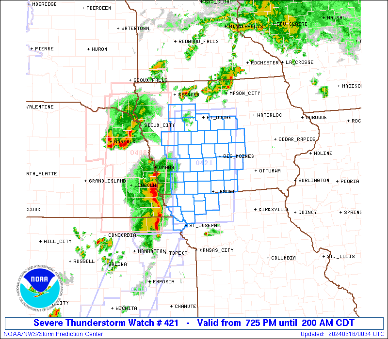
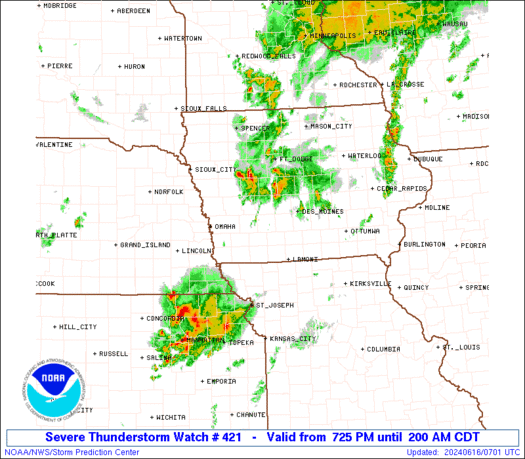
Severe Thunderstorm Watch Number 421
NWS Storm Prediction Center Norman OK
725 PM CDT Sat Jun 15 2024
The NWS Storm Prediction Center has issued a
* Severe Thunderstorm Watch for portions of
Western and Central Iowa
Far Northeastern Kansas
Northwest Missouri
* Effective this Saturday night and Sunday morning from 725 PM
until 200 AM CDT.
* Primary threats include...
Scattered damaging winds and isolated significant gusts to 75
mph possible
Isolated large hail events to 1.5 inches in diameter possible
A tornado or two possible
SUMMARY...A squall line will move northeastward into the Watch area
this evening. Severe gusts (60-75 mph) are possible with the more
intense portions of the squall line as it likely progresses west to
east across much of the Watch area. A tornado is possible,
especially with any longer-lived mesovortex circulation embedded
within the line. A large hail risk may accompany more cellular
storms later this evening into the early overnight.
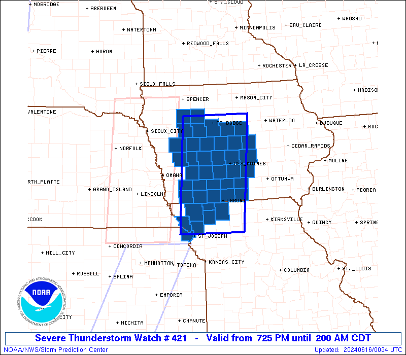
The severe thunderstorm watch area is approximately along and 55
statute miles east and west of a line from 15 miles north northeast
of Fort Dodge IA to 40 miles west of Chillicothe MO. For a complete
depiction of the watch see the associated watch outline update
(WOUS64 KWNS WOU1).
PRECAUTIONARY/PREPAREDNESS ACTIONS...
REMEMBER...A Severe Thunderstorm Watch means conditions are
favorable for severe thunderstorms in and close to the watch area.
Persons in these areas should be on the lookout for threatening
weather conditions and listen for later statements and possible
warnings. Severe thunderstorms can and occasionally do produce
tornadoes.
&&
OTHER WATCH INFORMATION...CONTINUE...WW 417...WW 418...WW
419...WW 420...
AVIATION...A few severe thunderstorms with hail surface and aloft to
1.5 inches. Extreme turbulence and surface wind gusts to 65 knots. A
few cumulonimbi with maximum tops to 500. Mean storm motion vector
23035.
...Smith
   SEL1

   URGENT - IMMEDIATE BROADCAST REQUESTED
   Severe Thunderstorm Watch Number 421
   NWS Storm Prediction Center Norman OK
   725 PM CDT Sat Jun 15 2024

   The NWS Storm Prediction Center has issued a

   * Severe Thunderstorm Watch for portions of
     Western and Central Iowa
     Far Northeastern Kansas
     Northwest Missouri

   * Effective this Saturday night and Sunday morning from 725 PM
     until 200 AM CDT.

   * Primary threats include...
     Scattered damaging winds and isolated significant gusts to 75
       mph possible
     Isolated large hail events to 1.5 inches in diameter possible
     A tornado or two possible

   SUMMARY...A squall line will move northeastward into the Watch area
   this evening.  Severe gusts (60-75 mph) are possible with the more
   intense portions of the squall line as it likely progresses west to
   east across much of the Watch area.  A tornado is possible,
   especially with any longer-lived mesovortex circulation embedded
   within the line.  A large hail risk may accompany more cellular
   storms later this evening into the early overnight.

   The severe thunderstorm watch area is approximately along and 55
   statute miles east and west of a line from 15 miles north northeast
   of Fort Dodge IA to 40 miles west of Chillicothe MO. For a complete
   depiction of the watch see the associated watch outline update
   (WOUS64 KWNS WOU1).

   PRECAUTIONARY/PREPAREDNESS ACTIONS...

   REMEMBER...A Severe Thunderstorm Watch means conditions are
   favorable for severe thunderstorms in and close to the watch area.
   Persons in these areas should be on the lookout for threatening
   weather conditions and listen for later statements and possible
   warnings. Severe thunderstorms can and occasionally do produce
   tornadoes.

   &&

   OTHER WATCH INFORMATION...CONTINUE...WW 417...WW 418...WW
   419...WW 420...

   AVIATION...A few severe thunderstorms with hail surface and aloft to
   1.5 inches. Extreme turbulence and surface wind gusts to 65 knots. A
   few cumulonimbi with maximum tops to 500. Mean storm motion vector
   23035.

   ...Smith
 Note:
The Aviation Watch (SAW) product is an approximation to the watch area.
The actual watch is depicted by the shaded areas.
Note:
The Aviation Watch (SAW) product is an approximation to the watch area.
The actual watch is depicted by the shaded areas.
SAW1
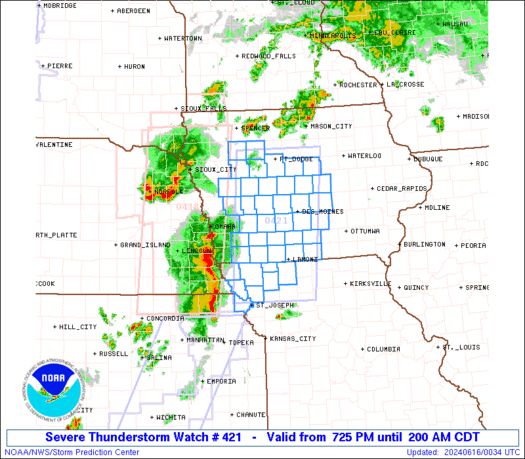
WW 421 SEVERE TSTM IA KS MO 160025Z - 160700Z
AXIS..55 STATUTE MILES EAST AND WEST OF LINE..
15NNE FOD/FORT DODGE IA/ - 40W CDJ/CHILLICOTHE MO/
..AVIATION COORDS.. 50NM E/W /12NE FOD - 37NNE MCI/
HAIL SURFACE AND ALOFT..1.5 INCHES. WIND GUSTS..65 KNOTS.
MAX TOPS TO 500. MEAN STORM MOTION VECTOR 23035.
LAT...LON 42759300 39819330 39819537 42759517
THIS IS AN APPROXIMATION TO THE WATCH AREA. FOR A
COMPLETE DEPICTION OF THE WATCH SEE WOUS64 KWNS
FOR WOU1.
Watch 421 Status Report Messages:
STATUS REPORT #3 ON WW 421
VALID 160455Z - 160540Z
SEVERE WEATHER THREAT CONTINUES RIGHT OF A LINE FROM 15 SSW FNB
TO 15 E LWD TO 35 NNE DSM TO 35 WNW CID.
..DEAN..06/16/24
ATTN...WFO...DMX...FSD...OAX...EAX...
&&
STATUS REPORT FOR WS 421
SEVERE WEATHER THREAT CONTINUES FOR THE FOLLOWING AREAS
IAC099-117-125-153-169-181-185-160540-
IA
. IOWA COUNTIES INCLUDED ARE
JASPER LUCAS MARION
POLK STORY WARREN
WAYNE
$$
THE WATCH STATUS MESSAGE IS FOR GUIDANCE PURPOSES ONLY. PLEASE
REFER TO WATCH COUNTY NOTIFICATION STATEMENTS FOR OFFICIAL
INFORMATION ON COUNTIES...INDEPENDENT CITIES AND MARINE ZONES
CLEARED FROM SEVERE THUNDERSTORM AND TORNADO WATCHES.
$$
STATUS REPORT #2 ON WW 421
VALID 160325Z - 160440Z
SEVERE WEATHER THREAT CONTINUES RIGHT OF A LINE FROM 10 S FNB TO
35 NW LWD TO 35 WNW DSM TO 5 NNE TQE.
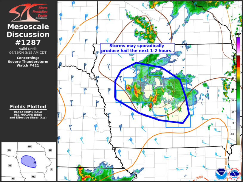
FOR ADDITIONAL INFORMATION SEE MESOSCALE DISCUSSION 1283
..DEAN..06/16/24
ATTN...WFO...DMX...FSD...OAX...EAX...
&&
STATUS REPORT FOR WS 421
SEVERE WEATHER THREAT CONTINUES FOR THE FOLLOWING AREAS
IAC015-021-025-027-039-041-047-049-053-059-073-079-083-099-117-
121-125-127-151-153-159-161-169-173-175-181-185-187-160440-
IA
. IOWA COUNTIES INCLUDED ARE
BOONE BUENA VISTA CALHOUN
CARROLL CLARKE CLAY
CRAWFORD DALLAS DECATUR
DICKINSON GREENE HAMILTON
HARDIN JASPER LUCAS
MADISON MARION MARSHALL
POCAHONTAS POLK RINGGOLD
SAC STORY TAYLOR
UNION WARREN WAYNE
WEBSTER
$$
KSC043-160440-
KS
. KANSAS COUNTIES INCLUDED ARE
DONIPHAN
$$
MOC003-075-081-087-147-227-160440-
MO
. MISSOURI COUNTIES INCLUDED ARE
ANDREW GENTRY HARRISON
HOLT NODAWAY WORTH
$$
THE WATCH STATUS MESSAGE IS FOR GUIDANCE PURPOSES ONLY. PLEASE
REFER TO WATCH COUNTY NOTIFICATION STATEMENTS FOR OFFICIAL
INFORMATION ON COUNTIES...INDEPENDENT CITIES AND MARINE ZONES
CLEARED FROM SEVERE THUNDERSTORM AND TORNADO WATCHES.
$$
STATUS REPORT #1 ON WW 421
VALID 160100Z - 160240Z
THE SEVERE WEATHER THREAT CONTINUES ACROSS THE ENTIRE WATCH AREA.
..DEAN..06/16/24
ATTN...WFO...DMX...FSD...OAX...EAX...
&&
STATUS REPORT FOR WS 421
SEVERE WEATHER THREAT CONTINUES FOR THE FOLLOWING AREAS
IAC001-003-009-015-021-025-027-029-039-047-049-053-073-077-079-
083-099-117-121-125-127-137-145-151-153-159-161-165-169-173-175-
181-185-187-160240-
IA
. IOWA COUNTIES INCLUDED ARE
ADAIR ADAMS AUDUBON
BOONE BUENA VISTA CALHOUN
CARROLL CASS CLARKE
CRAWFORD DALLAS DECATUR
GREENE GUTHRIE HAMILTON
HARDIN JASPER LUCAS
MADISON MARION MARSHALL
MONTGOMERY PAGE POCAHONTAS
POLK RINGGOLD SAC
SHELBY STORY TAYLOR
UNION WARREN WAYNE
WEBSTER
$$
KSC043-160240-
KS
. KANSAS COUNTIES INCLUDED ARE
DONIPHAN
$$
MOC003-075-081-087-147-227-160240-
MO
. MISSOURI COUNTIES INCLUDED ARE
ANDREW GENTRY HARRISON
HOLT NODAWAY WORTH
$$
THE WATCH STATUS MESSAGE IS FOR GUIDANCE PURPOSES ONLY. PLEASE
REFER TO WATCH COUNTY NOTIFICATION STATEMENTS FOR OFFICIAL
INFORMATION ON COUNTIES...INDEPENDENT CITIES AND MARINE ZONES
CLEARED FROM SEVERE THUNDERSTORM AND TORNADO WATCHES.
$$
Note:
Click for Complete Product Text.
Tornadoes
Probability of 2 or more tornadoes
|
Low (20%)
|
Probability of 1 or more strong (EF2-EF5) tornadoes
|
Low (5%)
|
Wind
Probability of 10 or more severe wind events
|
Mod (50%)
|
Probability of 1 or more wind events > 65 knots
|
Mod (30%)
|
Hail
Probability of 10 or more severe hail events
|
Mod (30%)
|
Probability of 1 or more hailstones > 2 inches
|
Low (20%)
|
Combined Severe Hail/Wind
Probability of 6 or more combined severe hail/wind events
|
High (70%)
|
For each watch, probabilities for particular events inside the watch
(listed above in each table) are determined by the issuing forecaster.
The "Low" category contains probability values ranging from less than 2%
to 20% (EF2-EF5 tornadoes), less than 5% to 20% (all other probabilities),
"Moderate" from 30% to 60%, and "High" from 70% to greater than 95%.
High values are bolded and lighter in color to provide awareness of
an increased threat for a particular event.


 @NWSSPC