 Note:
The expiration time in the watch graphic is amended if the watch is
replaced, cancelled or extended.
Note:
Note:
The expiration time in the watch graphic is amended if the watch is
replaced, cancelled or extended.
Note: Click for
Watch Status Reports.
SEL7
URGENT - IMMEDIATE BROADCAST REQUESTED
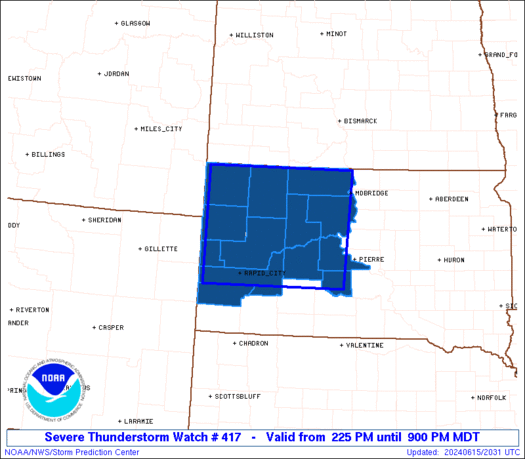
Severe Thunderstorm Watch Number 417
NWS Storm Prediction Center Norman OK
225 PM MDT Sat Jun 15 2024
The NWS Storm Prediction Center has issued a
* Severe Thunderstorm Watch for portions of
Western and Central South Dakota
* Effective this Saturday afternoon and evening from 225 PM until
900 PM MDT.
* Primary threats include...
Scattered damaging winds and isolated significant gusts to 75
mph possible
Scattered large hail and isolated very large hail events to 2
inches in diameter possible
SUMMARY...Thunderstorms should continue developing over the Black
Hills this afternoon. Large hail around 1-2 inches in diameter along
with severe/damaging winds of 60-75 mph will be possible as this
convection spreads eastward across parts of western and central
South Dakota through this evening.
The severe thunderstorm watch area is approximately along and 85
statute miles east and west of a line from Lemmon SD to 35 miles
west southwest of Philip SD. For a complete depiction of the watch
see the associated watch outline update (WOUS64 KWNS WOU7).
PRECAUTIONARY/PREPAREDNESS ACTIONS...
REMEMBER...A Severe Thunderstorm Watch means conditions are
favorable for severe thunderstorms in and close to the watch area.
Persons in these areas should be on the lookout for threatening
weather conditions and listen for later statements and possible
warnings. Severe thunderstorms can and occasionally do produce
tornadoes.
&&
AVIATION...A few severe thunderstorms with hail surface and aloft to
2 inches. Extreme turbulence and surface wind gusts to 65 knots. A
few cumulonimbi with maximum tops to 500. Mean storm motion vector
27035.
...Gleason
 Note:
The Aviation Watch (SAW) product is an approximation to the watch area.
The actual watch is depicted by the shaded areas.
Note:
The Aviation Watch (SAW) product is an approximation to the watch area.
The actual watch is depicted by the shaded areas.
   SAW7
   WW 417 SEVERE TSTM SD 152025Z - 160300Z
   AXIS..85 STATUTE MILES EAST AND WEST OF LINE..
   Y22/LEMMON SD/ - 35WSW PHP/PHILIP SD/
   ..AVIATION COORDS.. 75NM E/W /54NNW DPR - 34ESE RAP/
   HAIL SURFACE AND ALOFT..2 INCHES. WIND GUSTS..65 KNOTS.
   MAX TOPS TO 500. MEAN STORM MOTION VECTOR 27035.

   LAT...LON 45920040 43840054 43840395 45920394

   THIS IS AN APPROXIMATION TO THE WATCH AREA.  FOR A
   COMPLETE DEPICTION OF THE WATCH SEE WOUS64 KWNS
   FOR WOU7.
Watch 417 Status Report Messages:
STATUS REPORT #4 ON WW 417

VALID 160220Z - 160340Z

SEVERE WEATHER THREAT CONTINUES RIGHT OF A LINE FROM 50 SE RAP TO
40 W Y22.

..THORNTON..06/16/24

ATTN...WFO...UNR...ABR...

&&

STATUS REPORT FOR WS 417

SEVERE WEATHER THREAT CONTINUES FOR THE FOLLOWING AREAS

SDC031-041-055-071-075-095-105-117-137-160340-

SD
.    SOUTH DAKOTA COUNTIES INCLUDED ARE

CORSON		     DEWEY		 HAAKON
JACKSON 	     JONES		 MELLETTE
PERKINS 	     STANLEY		 ZIEBACH
$$


THE WATCH STATUS MESSAGE IS FOR GUIDANCE PURPOSES ONLY.  PLEASE
REFER TO WATCH COUNTY NOTIFICATION STATEMENTS FOR OFFICIAL
INFORMATION ON COUNTIES...INDEPENDENT CITIES AND MARINE ZONES
CLEARED FROM SEVERE THUNDERSTORM AND TORNADO WATCHES.
$$

STATUS REPORT #3 ON WW 417

VALID 160220Z - 160340Z

SEVERE WEATHER THREAT CONTINUES RIGHT OF A LINE FROM 50 SE RAP TO
40 W Y22.

..THORNTON..06/16/24

ATTN...WFO...UNR...ABR...

&&

STATUS REPORT FOR WS 417

SEVERE WEATHER THREAT CONTINUES FOR THE FOLLOWING AREAS

SDC031-041-055-071-075-095-105-117-137-160340-

SD
.    SOUTH DAKOTA COUNTIES INCLUDED ARE

CORSON		     DEWEY		 HAAKON
JACKSON 	     JONES		 MELLETTE
PERKINS 	     STANLEY		 ZIEBACH
$$


THE WATCH STATUS MESSAGE IS FOR GUIDANCE PURPOSES ONLY.  PLEASE
REFER TO WATCH COUNTY NOTIFICATION STATEMENTS FOR OFFICIAL
INFORMATION ON COUNTIES...INDEPENDENT CITIES AND MARINE ZONES
CLEARED FROM SEVERE THUNDERSTORM AND TORNADO WATCHES.
$$

STATUS REPORT #2 ON WW 417

VALID 152350Z - 160040Z

THE SEVERE WEATHER THREAT CONTINUES ACROSS THE ENTIRE WATCH AREA.

..THORNTON..06/15/24

ATTN...WFO...UNR...ABR...

&&

STATUS REPORT FOR WS 417

SEVERE WEATHER THREAT CONTINUES FOR THE FOLLOWING AREAS

SDC019-031-033-041-055-063-075-081-093-103-105-117-137-160040-

SD
.    SOUTH DAKOTA COUNTIES INCLUDED ARE

BUTTE		     CORSON		 CUSTER
DEWEY		     HAAKON		 HARDING
JONES		     LAWRENCE		 MEADE
PENNINGTON	     PERKINS		 STANLEY
ZIEBACH
$$


THE WATCH STATUS MESSAGE IS FOR GUIDANCE PURPOSES ONLY.  PLEASE
REFER TO WATCH COUNTY NOTIFICATION STATEMENTS FOR OFFICIAL
INFORMATION ON COUNTIES...INDEPENDENT CITIES AND MARINE ZONES
CLEARED FROM SEVERE THUNDERSTORM AND TORNADO WATCHES.
$$

STATUS REPORT #1 ON WW 417

VALID 152250Z - 152340Z

THE SEVERE WEATHER THREAT CONTINUES ACROSS THE ENTIRE WATCH AREA.

..THORNTON..06/15/24

ATTN...WFO...UNR...ABR...

&&

STATUS REPORT FOR WS 417

SEVERE WEATHER THREAT CONTINUES FOR THE FOLLOWING AREAS

SDC019-031-033-041-055-063-075-081-093-103-105-117-137-152340-

SD
.    SOUTH DAKOTA COUNTIES INCLUDED ARE

BUTTE		     CORSON		 CUSTER
DEWEY		     HAAKON		 HARDING
JONES		     LAWRENCE		 MEADE
PENNINGTON	     PERKINS		 STANLEY
ZIEBACH
$$


THE WATCH STATUS MESSAGE IS FOR GUIDANCE PURPOSES ONLY.  PLEASE
REFER TO WATCH COUNTY NOTIFICATION STATEMENTS FOR OFFICIAL
INFORMATION ON COUNTIES...INDEPENDENT CITIES AND MARINE ZONES
CLEARED FROM SEVERE THUNDERSTORM AND TORNADO WATCHES.
$$
Note:
Click for Complete Product Text.
Tornadoes
Probability of 2 or more tornadoes
|
Low (10%)
|
Probability of 1 or more strong (EF2-EF5) tornadoes
|
Low (5%)
|
Wind
Probability of 10 or more severe wind events
|
Mod (50%)
|
Probability of 1 or more wind events > 65 knots
|
Mod (30%)
|
Hail
Probability of 10 or more severe hail events
|
Mod (40%)
|
Probability of 1 or more hailstones > 2 inches
|
Mod (30%)
|
Combined Severe Hail/Wind
Probability of 6 or more combined severe hail/wind events
|
High (70%)
|
For each watch, probabilities for particular events inside the watch
(listed above in each table) are determined by the issuing forecaster.
The "Low" category contains probability values ranging from less than 2%
to 20% (EF2-EF5 tornadoes), less than 5% to 20% (all other probabilities),
"Moderate" from 30% to 60%, and "High" from 70% to greater than 95%.
High values are bolded and lighter in color to provide awareness of
an increased threat for a particular event.


 @NWSSPC


