 Note:
The expiration time in the watch graphic is amended if the watch is
replaced, cancelled or extended.
Note:
Note:
The expiration time in the watch graphic is amended if the watch is
replaced, cancelled or extended.
Note: Click for
Watch Status Reports.
SEL9
URGENT - IMMEDIATE BROADCAST REQUESTED
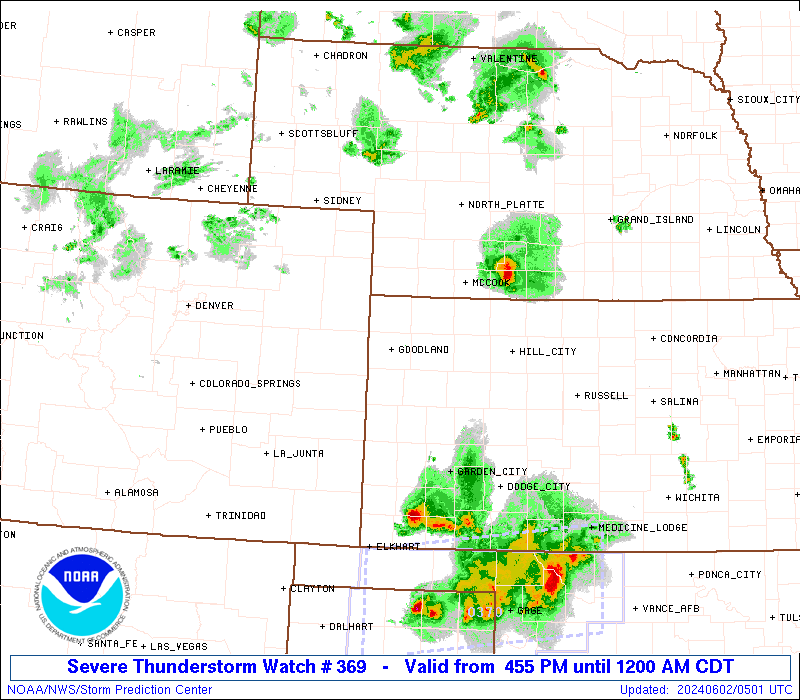
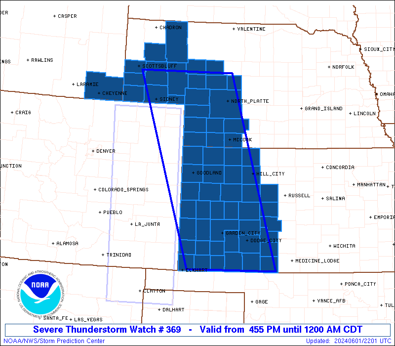
Severe Thunderstorm Watch Number 369
NWS Storm Prediction Center Norman OK
455 PM CDT Sat Jun 1 2024
The NWS Storm Prediction Center has issued a
* Severe Thunderstorm Watch for portions of
Western Kansas
Western Nebraska
Southeast Wyoming
* Effective this Saturday afternoon from 455 PM until Midnight
CDT.
* Primary threats include...
Scattered damaging winds and isolated significant gusts to 75
mph likely
Scattered large hail and isolated very large hail events to 2.5
inches in diameter possible
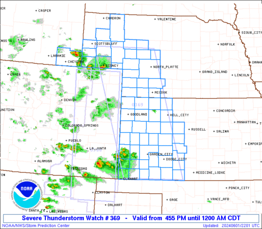
SUMMARY...Several clusters of thunderstorms will track eastward
across the watch area late this afternoon and evening. Damaging
winds are the primary threat with this activity, along with hail and
perhaps a tornado or two.
The severe thunderstorm watch area is approximately along and 75
statute miles east and west of a line from 70 miles northeast of
Sidney NE to 30 miles east of Liberal KS. For a complete depiction
of the watch see the associated watch outline update (WOUS64 KWNS
WOU9).
PRECAUTIONARY/PREPAREDNESS ACTIONS...
REMEMBER...A Severe Thunderstorm Watch means conditions are
favorable for severe thunderstorms in and close to the watch area.
Persons in these areas should be on the lookout for threatening
weather conditions and listen for later statements and possible
warnings. Severe thunderstorms can and occasionally do produce
tornadoes.
&&
OTHER WATCH INFORMATION...CONTINUE...WW 365...WW 366...WW
367...WW 368...
AVIATION...A few severe thunderstorms with hail surface and aloft to
2.5 inches. Extreme turbulence and surface wind gusts to 65 knots. A
few cumulonimbi with maximum tops to 500. Mean storm motion vector
27030.
...Hart

   SEL9

   URGENT - IMMEDIATE BROADCAST REQUESTED
   Severe Thunderstorm Watch Number 369
   NWS Storm Prediction Center Norman OK
   455 PM CDT Sat Jun 1 2024

   The NWS Storm Prediction Center has issued a

   * Severe Thunderstorm Watch for portions of
     Western Kansas
     Western Nebraska
     Southeast Wyoming

   * Effective this Saturday afternoon from 455 PM until Midnight
     CDT.

   * Primary threats include...
     Scattered damaging winds and isolated significant gusts to 75
       mph likely
     Scattered large hail and isolated very large hail events to 2.5
       inches in diameter possible

   SUMMARY...Several clusters of thunderstorms will track eastward
   across the watch area late this afternoon and evening.  Damaging
   winds are the primary threat with this activity, along with hail and
   perhaps a tornado or two.

   The severe thunderstorm watch area is approximately along and 75
   statute miles east and west of a line from 70 miles northeast of
   Sidney NE to 30 miles east of Liberal KS. For a complete depiction
   of the watch see the associated watch outline update (WOUS64 KWNS
   WOU9).

   PRECAUTIONARY/PREPAREDNESS ACTIONS...

   REMEMBER...A Severe Thunderstorm Watch means conditions are
   favorable for severe thunderstorms in and close to the watch area.
   Persons in these areas should be on the lookout for threatening
   weather conditions and listen for later statements and possible
   warnings. Severe thunderstorms can and occasionally do produce
   tornadoes.

   &&

   OTHER WATCH INFORMATION...CONTINUE...WW 365...WW 366...WW
   367...WW 368...

   AVIATION...A few severe thunderstorms with hail surface and aloft to
   2.5 inches. Extreme turbulence and surface wind gusts to 65 knots. A
   few cumulonimbi with maximum tops to 500. Mean storm motion vector
   27030.

   ...Hart
 Note:
The Aviation Watch (SAW) product is an approximation to the watch area.
The actual watch is depicted by the shaded areas.
Note:
The Aviation Watch (SAW) product is an approximation to the watch area.
The actual watch is depicted by the shaded areas.
   SAW9
   WW 369 SEVERE TSTM KS NE WY 012155Z - 020500Z
   AXIS..75 STATUTE MILES EAST AND WEST OF LINE..
   70NE SNY/SIDNEY NE/ - 30E LBL/LIBERAL KS/
   ..AVIATION COORDS.. 65NM E/W /61NE SNY - 26E LBL/
   HAIL SURFACE AND ALOFT..2.5 INCHES. WIND GUSTS..65 KNOTS.
   MAX TOPS TO 500. MEAN STORM MOTION VECTOR 27030.

   LAT...LON 41800056 37039907 37030179 41800348

   THIS IS AN APPROXIMATION TO THE WATCH AREA.  FOR A
   COMPLETE DEPICTION OF THE WATCH SEE WOUS64 KWNS
   FOR WOU9.
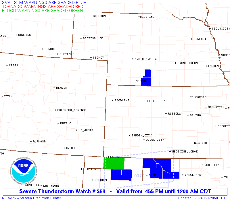
Watch 369 Status Report Messages:
STATUS REPORT #2 ON WW 369

VALID 020340Z - 020440Z

SEVERE WEATHER THREAT CONTINUES RIGHT OF A LINE FROM 10 ESE LBL
TO 35 SE DDC TO 40 WSW RSL TO 30 NW HLC TO 25 WSW MCK TO 20 ESE
IML TO 30 SSW LBF TO 30 ESE LBF.

..BROYLES..06/02/24

ATTN...WFO...GLD...DDC...LBF...CYS...

&&

STATUS REPORT FOR WS 369

SEVERE WEATHER THREAT CONTINUES FOR THE FOLLOWING AREAS

KSC025-033-039-051-065-097-137-145-165-020440-

KS
.    KANSAS COUNTIES INCLUDED ARE

CLARK		     COMANCHE		 DECATUR
ELLIS		     GRAHAM		 KIOWA
NORTON		     PAWNEE		 RUSH
$$


NEC087-145-161-020440-

NE
.    NEBRASKA COUNTIES INCLUDED ARE

HITCHCOCK	     RED WILLOW 	 SHERIDAN
$$


THE WATCH STATUS MESSAGE IS FOR GUIDANCE PURPOSES ONLY.  PLEASE
REFER TO WATCH COUNTY NOTIFICATION STATEMENTS FOR OFFICIAL
INFORMATION ON COUNTIES...INDEPENDENT CITIES AND MARINE ZONES
CLEARED FROM SEVERE THUNDERSTORM AND TORNADO WATCHES.
$$

STATUS REPORT #1 ON WW 369

VALID 020135Z - 020240Z

SEVERE WEATHER THREAT CONTINUES RIGHT OF A LINE FROM 15 W EHA TO
50 W GCK TO 60 N GCK TO 50 WSW HLC TO 45 S MCK TO 40 SW IML TO 35
WSW IML TO 10 SE SNY TO 15 NW SNY TO 35 SSW BFF TO 30 NE CYS.

..LYONS..06/02/24

ATTN...WFO...GLD...DDC...LBF...CYS...

&&

STATUS REPORT FOR WS 369

SEVERE WEATHER THREAT CONTINUES FOR THE FOLLOWING AREAS

KSC025-033-039-047-051-055-057-063-065-067-069-081-083-093-097-
101-119-129-135-137-145-153-165-171-175-179-187-189-195-
020240-

KS
.    KANSAS COUNTIES INCLUDED ARE

CLARK		     COMANCHE		 DECATUR
EDWARDS 	     ELLIS		 FINNEY
FORD		     GOVE		 GRAHAM
GRANT		     GRAY		 HASKELL
HODGEMAN	     KEARNY		 KIOWA
LANE		     MEADE		 MORTON
NESS		     NORTON		 PAWNEE
RAWLINS 	     RUSH		 SCOTT
SEWARD		     SHERIDAN		 STANTON
STEVENS 	     TREGO
$$


NEC005-007-013-029-033-049-057-063-069-075-085-087-091-101-111-
113-117-123-135-145-157-161-020240-

NE
.    NEBRASKA COUNTIES INCLUDED ARE

ARTHUR		     BANNER		 BOX BUTTE
CHASE		     CHEYENNE		 DEUEL
DUNDY		     FRONTIER		 GARDEN
GRANT		     HAYES		 HITCHCOCK
HOOKER		     KEITH		 LINCOLN
LOGAN		     MCPHERSON		 MORRILL
PERKINS 	     RED WILLOW 	 SCOTTS BLUFF
SHERIDAN
$$


THE WATCH STATUS MESSAGE IS FOR GUIDANCE PURPOSES ONLY.  PLEASE
REFER TO WATCH COUNTY NOTIFICATION STATEMENTS FOR OFFICIAL
INFORMATION ON COUNTIES...INDEPENDENT CITIES AND MARINE ZONES
CLEARED FROM SEVERE THUNDERSTORM AND TORNADO WATCHES.
$$
Note:
Click for Complete Product Text.
Tornadoes
Probability of 2 or more tornadoes
|
Low (10%)
|
Probability of 1 or more strong (EF2-EF5) tornadoes
|
Low (<2%)
|
Wind
Probability of 10 or more severe wind events
|
High (70%)
|
Probability of 1 or more wind events > 65 knots
|
Mod (60%)
|
Hail
Probability of 10 or more severe hail events
|
Mod (50%)
|
Probability of 1 or more hailstones > 2 inches
|
Mod (40%)
|
Combined Severe Hail/Wind
Probability of 6 or more combined severe hail/wind events
|
High (>95%)
|
For each watch, probabilities for particular events inside the watch
(listed above in each table) are determined by the issuing forecaster.
The "Low" category contains probability values ranging from less than 2%
to 20% (EF2-EF5 tornadoes), less than 5% to 20% (all other probabilities),
"Moderate" from 30% to 60%, and "High" from 70% to greater than 95%.
High values are bolded and lighter in color to provide awareness of
an increased threat for a particular event.


 @NWSSPC