 Note:
The expiration time in the watch graphic is amended if the watch is
replaced, cancelled or extended.
Note:
Note:
The expiration time in the watch graphic is amended if the watch is
replaced, cancelled or extended.
Note: Click for
Watch Status Reports.
SEL7
URGENT - IMMEDIATE BROADCAST REQUESTED
Severe Thunderstorm Watch Number 367
NWS Storm Prediction Center Norman OK
335 PM CDT Sat Jun 1 2024
The NWS Storm Prediction Center has issued a
* Severe Thunderstorm Watch for portions of
Northwest Louisiana
East Texas
* Effective this Saturday afternoon and evening from 335 PM until
900 PM CDT.
* Primary threats include...
Scattered damaging wind gusts to 70 mph possible
Isolated large hail events to 1.5 inches in diameter possible
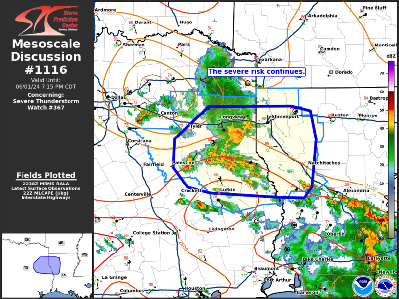
SUMMARY...A thunderstorm cluster associated with an mid-level
disturbance will likely continue east across eastern portions of
Texas into northwest Louisiana this afternoon into the evening. A
belt of enhanced mid-level flow coupled with a warm and unstable
airmass ahead of these thunderstorms, will probably sustain this
thunderstorm cluster into the evening. The stronger thunderstorm
cores will be potentially capable of locally severe and damaging
gusts and possibly large hail.
The severe thunderstorm watch area is approximately along and 50
statute miles north and south of a line from 45 miles west southwest
of Tyler TX to 20 miles north northeast of Natchitoches LA. For a
complete depiction of the watch see the associated watch outline
update (WOUS64 KWNS WOU7).
PRECAUTIONARY/PREPAREDNESS ACTIONS...
REMEMBER...A Severe Thunderstorm Watch means conditions are
favorable for severe thunderstorms in and close to the watch area.
Persons in these areas should be on the lookout for threatening
weather conditions and listen for later statements and possible
warnings. Severe thunderstorms can and occasionally do produce
tornadoes.
&&
OTHER WATCH INFORMATION...CONTINUE...WW 365...WW 366...
AVIATION...A few severe thunderstorms with hail surface and aloft to
1.5 inches. Extreme turbulence and surface wind gusts to 60 knots. A
few cumulonimbi with maximum tops to 550. Mean storm motion vector
28030.
...Smith

   SEL7

   URGENT - IMMEDIATE BROADCAST REQUESTED
   Severe Thunderstorm Watch Number 367
   NWS Storm Prediction Center Norman OK
   335 PM CDT Sat Jun 1 2024

   The NWS Storm Prediction Center has issued a

   * Severe Thunderstorm Watch for portions of
     Northwest Louisiana
     East Texas

   * Effective this Saturday afternoon and evening from 335 PM until
     900 PM CDT.

   * Primary threats include...
     Scattered damaging wind gusts to 70 mph possible
     Isolated large hail events to 1.5 inches in diameter possible

   SUMMARY...A thunderstorm cluster associated with an mid-level
   disturbance will likely continue east across eastern portions of
   Texas into northwest Louisiana this afternoon into the evening.  A
   belt of enhanced mid-level flow coupled with a warm and unstable
   airmass ahead of these thunderstorms, will probably sustain this
   thunderstorm cluster into the evening.  The stronger thunderstorm
   cores will be potentially capable of locally severe and damaging
   gusts and possibly large hail.

   The severe thunderstorm watch area is approximately along and 50
   statute miles north and south of a line from 45 miles west southwest
   of Tyler TX to 20 miles north northeast of Natchitoches LA. For a
   complete depiction of the watch see the associated watch outline
   update (WOUS64 KWNS WOU7).

   PRECAUTIONARY/PREPAREDNESS ACTIONS...

   REMEMBER...A Severe Thunderstorm Watch means conditions are
   favorable for severe thunderstorms in and close to the watch area.
   Persons in these areas should be on the lookout for threatening
   weather conditions and listen for later statements and possible
   warnings. Severe thunderstorms can and occasionally do produce
   tornadoes.

   &&

   OTHER WATCH INFORMATION...CONTINUE...WW 365...WW 366...

   AVIATION...A few severe thunderstorms with hail surface and aloft to
   1.5 inches. Extreme turbulence and surface wind gusts to 60 knots. A
   few cumulonimbi with maximum tops to 550. Mean storm motion vector
   28030.

   ...Smith
 Note:
The Aviation Watch (SAW) product is an approximation to the watch area.
The actual watch is depicted by the shaded areas.
Note:
The Aviation Watch (SAW) product is an approximation to the watch area.
The actual watch is depicted by the shaded areas.
   SAW7
   WW 367 SEVERE TSTM LA TX 012035Z - 020200Z
   AXIS..50 STATUTE MILES NORTH AND SOUTH OF LINE..
   45WSW TYR/TYLER TX/ - 20NNE IER/NATCHITOCHES LA/
   ..AVIATION COORDS.. 45NM N/S /65ENE ACT - 51NNW AEX/
   HAIL SURFACE AND ALOFT..1.5 INCHES. WIND GUSTS..60 KNOTS.
   MAX TOPS TO 550. MEAN STORM MOTION VECTOR 28030.

   LAT...LON 32829611 32739297 31289297 31389611

   THIS IS AN APPROXIMATION TO THE WATCH AREA.  FOR A
   COMPLETE DEPICTION OF THE WATCH SEE WOUS64 KWNS
   FOR WOU7.
Watch 367 Status Report Messages:
STATUS REPORT #3 ON WW 367

VALID 020110Z - 020240Z

SEVERE WEATHER THREAT CONTINUES RIGHT OF A LINE FROM 20 WNW LFK
TO 50 WSW IER TO 15 WNW IER TO 25 ESE SHV TO 30 NNE SHV.

..BROYLES..06/02/24

ATTN...WFO...SHV...FWD...

&&

STATUS REPORT FOR WS 367

SEVERE WEATHER THREAT CONTINUES FOR THE FOLLOWING AREAS

LAC013-021-043-049-059-069-073-085-119-127-020240-

LA
.    LOUISIANA PARISHES INCLUDED ARE

BIENVILLE	     CALDWELL		 GRANT
JACKSON 	     LA SALLE		 NATCHITOCHES
OUACHITA	     SABINE		 WEBSTER
WINN
$$


TXC005-403-405-020240-

TX
.    TEXAS COUNTIES INCLUDED ARE

ANGELINA	     SABINE		 SAN AUGUSTINE
$$


THE WATCH STATUS MESSAGE IS FOR GUIDANCE PURPOSES ONLY.  PLEASE
REFER TO WATCH COUNTY NOTIFICATION STATEMENTS FOR OFFICIAL
INFORMATION ON COUNTIES...INDEPENDENT CITIES AND MARINE ZONES
CLEARED FROM SEVERE THUNDERSTORM AND TORNADO WATCHES.
$$

STATUS REPORT #2 ON WW 367

VALID 020015Z - 020140Z

SEVERE WEATHER THREAT CONTINUES RIGHT OF A LINE FROM 45 N UTS TO
35 N LFK TO 35 SSW SHV TO 5 S SHV TO 35 SSE TXK.

..LYONS..06/02/24

ATTN...WFO...SHV...FWD...

&&

STATUS REPORT FOR WS 367

SEVERE WEATHER THREAT CONTINUES FOR THE FOLLOWING AREAS

LAC013-015-021-031-043-049-059-069-073-081-085-119-127-020140-

LA
.    LOUISIANA PARISHES INCLUDED ARE

BIENVILLE	     BOSSIER		 CALDWELL
DE SOTO 	     GRANT		 JACKSON
LA SALLE	     NATCHITOCHES	 OUACHITA
RED RIVER	     SABINE		 WEBSTER
WINN
$$


TXC005-403-405-419-020140-

TX
.    TEXAS COUNTIES INCLUDED ARE

ANGELINA	     SABINE		 SAN AUGUSTINE
SHELBY
$$


THE WATCH STATUS MESSAGE IS FOR GUIDANCE PURPOSES ONLY.  PLEASE
REFER TO WATCH COUNTY NOTIFICATION STATEMENTS FOR OFFICIAL
INFORMATION ON COUNTIES...INDEPENDENT CITIES AND MARINE ZONES
CLEARED FROM SEVERE THUNDERSTORM AND TORNADO WATCHES.
$$

STATUS REPORT #1 ON WW 367

VALID 012300Z - 020040Z

SEVERE WEATHER THREAT CONTINUES RIGHT OF A LINE FROM 45 ESE DAL
TO 20 NNE TYR TO 15 N GGG TO 25 NE GGG TO 35 SSW TXK.

..LYONS..06/01/24

ATTN...WFO...SHV...FWD...

&&

STATUS REPORT FOR WS 367

SEVERE WEATHER THREAT CONTINUES FOR THE FOLLOWING AREAS

LAC013-015-017-031-069-081-085-119-020040-

LA
.    LOUISIANA PARISHES INCLUDED ARE

BIENVILLE	     BOSSIER		 CADDO
DE SOTO 	     NATCHITOCHES	 RED RIVER
SABINE		     WEBSTER
$$


TXC001-005-073-183-203-213-347-365-401-403-405-419-423-020040-

TX
.    TEXAS COUNTIES INCLUDED ARE

ANDERSON	     ANGELINA		 CHEROKEE
GREGG		     HARRISON		 HENDERSON
NACOGDOCHES	     PANOLA		 RUSK
SABINE		     SAN AUGUSTINE	 SHELBY
SMITH
$$


THE WATCH STATUS MESSAGE IS FOR GUIDANCE PURPOSES ONLY.  PLEASE
REFER TO WATCH COUNTY NOTIFICATION STATEMENTS FOR OFFICIAL
INFORMATION ON COUNTIES...INDEPENDENT CITIES AND MARINE ZONES
CLEARED FROM SEVERE THUNDERSTORM AND TORNADO WATCHES.
$$
Note:
Click for Complete Product Text.
Tornadoes
Probability of 2 or more tornadoes
|
Low (<5%)
|
Probability of 1 or more strong (EF2-EF5) tornadoes
|
Low (<2%)
|
Wind
Probability of 10 or more severe wind events
|
Mod (40%)
|
Probability of 1 or more wind events > 65 knots
|
Low (20%)
|
Hail
Probability of 10 or more severe hail events
|
Mod (30%)
|
Probability of 1 or more hailstones > 2 inches
|
Low (20%)
|
Combined Severe Hail/Wind
Probability of 6 or more combined severe hail/wind events
|
High (70%)
|
For each watch, probabilities for particular events inside the watch
(listed above in each table) are determined by the issuing forecaster.
The "Low" category contains probability values ranging from less than 2%
to 20% (EF2-EF5 tornadoes), less than 5% to 20% (all other probabilities),
"Moderate" from 30% to 60%, and "High" from 70% to greater than 95%.
High values are bolded and lighter in color to provide awareness of
an increased threat for a particular event.


 @NWSSPC