|
| Mesoscale Discussion 1119 |
|
< Previous MD Next MD >
|
|
Mesoscale Discussion 1119
NWS Storm Prediction Center Norman OK
0800 PM CDT Sat Jun 01 2024
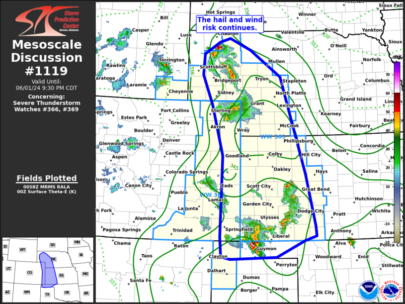
Areas affected...portions of western Nebraska and Kansas into
eastern Colorado
Concerning...Severe Thunderstorm Watch 366...369...
Valid 020100Z - 020230Z
The severe weather threat for Severe Thunderstorm Watch 366, 369
continues.
SUMMARY...The severe risk continues. Several dominant clusters
appear to be emerging and should present the most severe risk into
this evening.
DISCUSSION...Across WW 366 and 369, widely scattered thunderstorms
have gradually coalesced into 2 more dominant clusters over the last
couple of hours. This trend will likely continue into this evening
as diurnal heating weakens and cold pool depth increases. The
northern most cluster over CO and NE will likely continue to pose a
risk for hail and damaging winds with several more supercellular
elements noted on radar. However, eventual upscale growth appears
likely given moderate to large MLCAPE and some low-level warm
advection increases expected with the onset of the nocturnal LLJ. A
transition to more damaging wind potential appears likely over the
next few hours as storms should eventually grow upscale.
The southern cluster over parts of KS and the OK Panhandle has shown
less organization thus far owing to weaker buoyancy and a more
multi-cell mode. Still, some more organized elements may appear over
the next few hours as the cold pool continues to deepen and move
southeast. Damaging winds appear to be the most likely threat as the
eventual cluster should propagate southeastward into western OK and
the TX Panhandle, though some hail still appears possible.
..Lyons.. 06/02/2024
...Please see www.spc.noaa.gov for graphic product...
ATTN...WFO...OUN...GID...LBF...DDC...GLD...AMA...PUB...BOU...
CYS...
LAT...LON 36520072 36460239 36540272 37110277 37470276 39420270
40900310 41740347 42340342 42670285 42780245 42450168
41680056 38909966 37419932 37129929 36999971 36520072
|
|
Top/All Mesoscale Discussions/Forecast Products/Home
|
|


 @NWSSPC