Note:
The expiration time in the watch graphic is amended if the watch is
replaced, cancelled or extended.
Note:
Note:
The expiration time in the watch graphic is amended if the watch is
replaced, cancelled or extended.
Note: Click for
Watch Status Reports.
SEL6
URGENT - IMMEDIATE BROADCAST REQUESTED
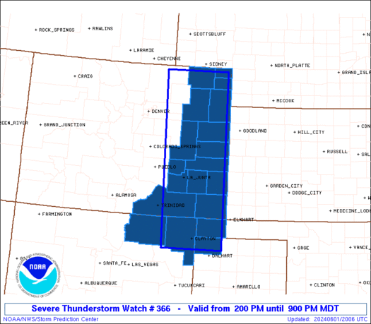
Severe Thunderstorm Watch Number 366
NWS Storm Prediction Center Norman OK
200 PM MDT Sat Jun 1 2024
The NWS Storm Prediction Center has issued a
* Severe Thunderstorm Watch for portions of
Eastern Colorado
Northeast New Mexico
Western Oklahoma Panhandle
Northwest part of the Texas Panhandle
* Effective this Saturday afternoon and evening from 200 PM until
900 PM MDT.
* Primary threats include...
Scattered large hail and isolated very large hail events to 2
inches in diameter likely
Scattered damaging winds likely with isolated significant gusts
to 75 mph possible
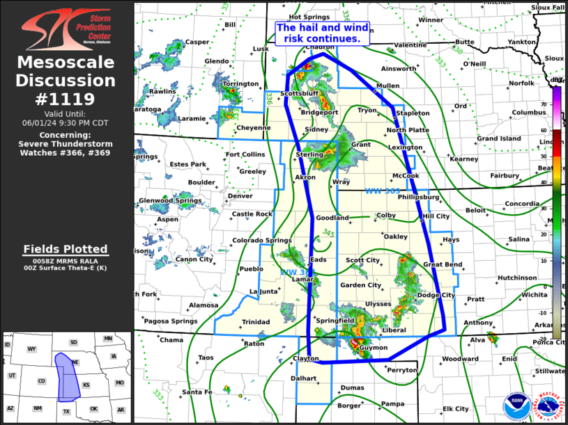
SUMMARY...Scattered thunderstorms are forecast to develop and
intensify this afternoon into the early evening across the Watch
area. The stronger storms, including the possibility for a few
supercells, will potentially be capable of large to very large hail
and severe gusts. A few small clusters may eventually evolve
towards late afternoon and early evening near the Colorado-Kansas
border and pose an increasing threat for severe gusts.
The severe thunderstorm watch area is approximately along and 55
statute miles east and west of a line from 20 miles south of Clayton
NM to 50 miles north of Akron CO. For a complete depiction of the
watch see the associated watch outline update (WOUS64 KWNS WOU6).
PRECAUTIONARY/PREPAREDNESS ACTIONS...
REMEMBER...A Severe Thunderstorm Watch means conditions are
favorable for severe thunderstorms in and close to the watch area.
Persons in these areas should be on the lookout for threatening
weather conditions and listen for later statements and possible
warnings. Severe thunderstorms can and occasionally do produce
tornadoes.
&&
OTHER WATCH INFORMATION...CONTINUE...WW 365...
AVIATION...A few severe thunderstorms with hail surface and aloft to
2 inches. Extreme turbulence and surface wind gusts to 65 knots. A
few cumulonimbi with maximum tops to 450. Mean storm motion vector
27025.
...Smith

   SEL6

   URGENT - IMMEDIATE BROADCAST REQUESTED
   Severe Thunderstorm Watch Number 366
   NWS Storm Prediction Center Norman OK
   200 PM MDT Sat Jun 1 2024

   The NWS Storm Prediction Center has issued a

   * Severe Thunderstorm Watch for portions of
     Eastern Colorado
     Northeast New Mexico
     Western Oklahoma Panhandle
     Northwest part of the Texas Panhandle

   * Effective this Saturday afternoon and evening from 200 PM until
     900 PM MDT.

   * Primary threats include...
     Scattered large hail and isolated very large hail events to 2
       inches in diameter likely
     Scattered damaging winds likely with isolated significant gusts
       to 75 mph possible

   SUMMARY...Scattered thunderstorms are forecast to develop and
   intensify this afternoon into the early evening across the Watch
   area.  The stronger storms, including the possibility for a few
   supercells, will potentially be capable of large to very large hail
   and severe gusts.  A few small clusters may eventually evolve
   towards late afternoon and early evening near the Colorado-Kansas
   border and pose an increasing threat for severe gusts.

   The severe thunderstorm watch area is approximately along and 55
   statute miles east and west of a line from 20 miles south of Clayton
   NM to 50 miles north of Akron CO. For a complete depiction of the
   watch see the associated watch outline update (WOUS64 KWNS WOU6).

   PRECAUTIONARY/PREPAREDNESS ACTIONS...

   REMEMBER...A Severe Thunderstorm Watch means conditions are
   favorable for severe thunderstorms in and close to the watch area.
   Persons in these areas should be on the lookout for threatening
   weather conditions and listen for later statements and possible
   warnings. Severe thunderstorms can and occasionally do produce
   tornadoes.

   &&

   OTHER WATCH INFORMATION...CONTINUE...WW 365...

   AVIATION...A few severe thunderstorms with hail surface and aloft to
   2 inches. Extreme turbulence and surface wind gusts to 65 knots. A
   few cumulonimbi with maximum tops to 450. Mean storm motion vector
   27025.

   ...Smith
 Note:
The Aviation Watch (SAW) product is an approximation to the watch area.
The actual watch is depicted by the shaded areas.
Note:
The Aviation Watch (SAW) product is an approximation to the watch area.
The actual watch is depicted by the shaded areas.
   SAW6
   WW 366 SEVERE TSTM CO NM OK TX 012000Z - 020300Z
   AXIS..55 STATUTE MILES EAST AND WEST OF LINE..
   20S CAO/CLAYTON NM/ - 50N AKO/AKRON CO/
   ..AVIATION COORDS.. 50NM E/W /63NNE TCC - 16SW SNY/
   HAIL SURFACE AND ALOFT..2 INCHES. WIND GUSTS..65 KNOTS.
   MAX TOPS TO 450. MEAN STORM MOTION VECTOR 27025.

   LAT...LON 36160414 40900427 40900217 36160216

   THIS IS AN APPROXIMATION TO THE WATCH AREA.  FOR A
   COMPLETE DEPICTION OF THE WATCH SEE WOUS64 KWNS
   FOR WOU6.
Watch 366 Status Report Message has not been issued yet.
Note:
Click for Complete Product Text.
Tornadoes
Probability of 2 or more tornadoes
|
Low (10%)
|
Probability of 1 or more strong (EF2-EF5) tornadoes
|
Low (<2%)
|
Wind
Probability of 10 or more severe wind events
|
Mod (60%)
|
Probability of 1 or more wind events > 65 knots
|
Mod (30%)
|
Hail
Probability of 10 or more severe hail events
|
Mod (60%)
|
Probability of 1 or more hailstones > 2 inches
|
Mod (60%)
|
Combined Severe Hail/Wind
Probability of 6 or more combined severe hail/wind events
|
High (>95%)
|
For each watch, probabilities for particular events inside the watch
(listed above in each table) are determined by the issuing forecaster.
The "Low" category contains probability values ranging from less than 2%
to 20% (EF2-EF5 tornadoes), less than 5% to 20% (all other probabilities),
"Moderate" from 30% to 60%, and "High" from 70% to greater than 95%.
High values are bolded and lighter in color to provide awareness of
an increased threat for a particular event.


 @NWSSPC