 Note:
The expiration time in the watch graphic is amended if the watch is
replaced, cancelled or extended.
Note:
Note:
The expiration time in the watch graphic is amended if the watch is
replaced, cancelled or extended.
Note: Click for
Watch Status Reports.
SEL8
URGENT - IMMEDIATE BROADCAST REQUESTED
Severe Thunderstorm Watch Number 368
NWS Storm Prediction Center Norman OK
355 PM CDT Sat Jun 1 2024
The NWS Storm Prediction Center has issued a
* Severe Thunderstorm Watch for portions of
Southeast New Mexico
Southwest Texas
* Effective this Saturday afternoon and evening from 355 PM until
1100 PM CDT.
* Primary threats include...
Scattered large hail and isolated very large hail events to 3.5
inches in diameter likely
Scattered damaging winds and isolated significant gusts to 75
mph possible
A tornado or two possible
SUMMARY...Widely scattered to scattered thunderstorms are forecast
to develop this afternoon into the early evening. Supercells
capable of large to giant hail will be possible. As storms mature
into the early evening, a tornado risk may also develop for an hour
or two as storms move into richer moisture over parts of the Pecos
Valley. A cluster of severe storms may evolve towards the mid to
late evening with an increasing risk for severe gusts accompanying
these storms.
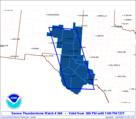
The severe thunderstorm watch area is approximately along and 75
statute miles east and west of a line from 60 miles north northwest
of Roswell NM to 60 miles southwest of Dryden TX. For a complete
depiction of the watch see the associated watch outline update
(WOUS64 KWNS WOU8).
PRECAUTIONARY/PREPAREDNESS ACTIONS...
REMEMBER...A Severe Thunderstorm Watch means conditions are
favorable for severe thunderstorms in and close to the watch area.
Persons in these areas should be on the lookout for threatening
weather conditions and listen for later statements and possible
warnings. Severe thunderstorms can and occasionally do produce
tornadoes.
&&
OTHER WATCH INFORMATION...CONTINUE...WW 365...WW 366...WW 367...
AVIATION...A few severe thunderstorms with hail surface and aloft to
3.5 inches. Extreme turbulence and surface wind gusts to 65 knots. A
few cumulonimbi with maximum tops to 500. Mean storm motion vector
27020.
...Smith

   SEL8

   URGENT - IMMEDIATE BROADCAST REQUESTED
   Severe Thunderstorm Watch Number 368
   NWS Storm Prediction Center Norman OK
   355 PM CDT Sat Jun 1 2024

   The NWS Storm Prediction Center has issued a

   * Severe Thunderstorm Watch for portions of
     Southeast New Mexico
     Southwest Texas

   * Effective this Saturday afternoon and evening from 355 PM until
     1100 PM CDT.

   * Primary threats include...
     Scattered large hail and isolated very large hail events to 3.5
       inches in diameter likely
     Scattered damaging winds and isolated significant gusts to 75
       mph possible
     A tornado or two possible

   SUMMARY...Widely scattered to scattered thunderstorms are forecast
   to develop this afternoon into the early evening.  Supercells
   capable of large to giant hail will be possible.  As storms mature
   into the early evening, a tornado risk may also develop for an hour
   or two as storms move into richer moisture over parts of the Pecos
   Valley.  A cluster of severe storms may evolve towards the mid to
   late evening with an increasing risk for severe gusts accompanying
   these storms.

   The severe thunderstorm watch area is approximately along and 75
   statute miles east and west of a line from 60 miles north northwest
   of Roswell NM to 60 miles southwest of Dryden TX. For a complete
   depiction of the watch see the associated watch outline update
   (WOUS64 KWNS WOU8).

   PRECAUTIONARY/PREPAREDNESS ACTIONS...

   REMEMBER...A Severe Thunderstorm Watch means conditions are
   favorable for severe thunderstorms in and close to the watch area.
   Persons in these areas should be on the lookout for threatening
   weather conditions and listen for later statements and possible
   warnings. Severe thunderstorms can and occasionally do produce
   tornadoes.

   &&

   OTHER WATCH INFORMATION...CONTINUE...WW 365...WW 366...WW 367...

   AVIATION...A few severe thunderstorms with hail surface and aloft to
   3.5 inches. Extreme turbulence and surface wind gusts to 65 knots. A
   few cumulonimbi with maximum tops to 500. Mean storm motion vector
   27020.

   ...Smith
 Note:
The Aviation Watch (SAW) product is an approximation to the watch area.
The actual watch is depicted by the shaded areas.
Note:
The Aviation Watch (SAW) product is an approximation to the watch area.
The actual watch is depicted by the shaded areas.
   SAW8
   WW 368 SEVERE TSTM NM TX 012055Z - 020400Z
   AXIS..75 STATUTE MILES EAST AND WEST OF LINE..
   60NNW ROW/ROSWELL NM/ - 60SW 6R6/DRYDEN TX/
   ..AVIATION COORDS.. 65NM E/W /48NNW CME - 75SE MRF/
   HAIL SURFACE AND ALOFT..3.5 INCHES. WIND GUSTS..65 KNOTS.
   MAX TOPS TO 500. MEAN STORM MOTION VECTOR 27020.

   LAT...LON 34080362 29420167 29420416 34080624

   THIS IS AN APPROXIMATION TO THE WATCH AREA.  FOR A
   COMPLETE DEPICTION OF THE WATCH SEE WOUS64 KWNS
   FOR WOU8.
Watch 368 Status Report Messages:
STATUS REPORT #5 ON WW 368

VALID 020230Z - 020340Z

SEVERE WEATHER THREAT CONTINUES RIGHT OF A LINE FROM 80 S MRF TO
40 W FST TO 45 ENE FST.

..BROYLES..06/02/24

ATTN...WFO...ABQ...MAF...

&&

STATUS REPORT FOR WS 368

SEVERE WEATHER THREAT CONTINUES FOR THE FOLLOWING AREAS

TXC043-371-443-020340-

TX
.    TEXAS COUNTIES INCLUDED ARE

BREWSTER	     PECOS		 TERRELL
$$


THE WATCH STATUS MESSAGE IS FOR GUIDANCE PURPOSES ONLY.  PLEASE
REFER TO WATCH COUNTY NOTIFICATION STATEMENTS FOR OFFICIAL
INFORMATION ON COUNTIES...INDEPENDENT CITIES AND MARINE ZONES
CLEARED FROM SEVERE THUNDERSTORM AND TORNADO WATCHES.
$$

STATUS REPORT #4 ON WW 368

VALID 020205Z - 020340Z

SEVERE WEATHER THREAT CONTINUES RIGHT OF A LINE FROM 90 S MRF TO
5 NE MRF TO 45 S GDP TO 15 SE GDP TO 15 E HOB.

..BROYLES..06/02/24

ATTN...WFO...ABQ...MAF...

&&

STATUS REPORT FOR WS 368

SEVERE WEATHER THREAT CONTINUES FOR THE FOLLOWING AREAS

TXC043-103-109-243-301-371-389-443-475-495-020340-

TX
.    TEXAS COUNTIES INCLUDED ARE

BREWSTER	     CRANE		 CULBERSON
JEFF DAVIS	     LOVING		 PECOS
REEVES		     TERRELL		 WARD
WINKLER
$$


THE WATCH STATUS MESSAGE IS FOR GUIDANCE PURPOSES ONLY.  PLEASE
REFER TO WATCH COUNTY NOTIFICATION STATEMENTS FOR OFFICIAL
INFORMATION ON COUNTIES...INDEPENDENT CITIES AND MARINE ZONES
CLEARED FROM SEVERE THUNDERSTORM AND TORNADO WATCHES.
$$

STATUS REPORT #3 ON WW 368

VALID 020025Z - 020140Z

SEVERE WEATHER THREAT CONTINUES RIGHT OF A LINE FROM 15 ENE ALM
TO 40 NNE HOB.

..BROYLES..06/02/24

ATTN...WFO...ABQ...MAF...

&&

STATUS REPORT FOR WS 368

SEVERE WEATHER THREAT CONTINUES FOR THE FOLLOWING AREAS

NMC015-025-020140-

NM
.    NEW MEXICO COUNTIES INCLUDED ARE

EDDY		     LEA
$$


TXC043-103-109-243-301-371-377-389-443-475-495-020140-

TX
.    TEXAS COUNTIES INCLUDED ARE

BREWSTER	     CRANE		 CULBERSON
JEFF DAVIS	     LOVING		 PECOS
PRESIDIO	     REEVES		 TERRELL
WARD		     WINKLER
$$


THE WATCH STATUS MESSAGE IS FOR GUIDANCE PURPOSES ONLY.  PLEASE
REFER TO WATCH COUNTY NOTIFICATION STATEMENTS FOR OFFICIAL
INFORMATION ON COUNTIES...INDEPENDENT CITIES AND MARINE ZONES
CLEARED FROM SEVERE THUNDERSTORM AND TORNADO WATCHES.
$$

STATUS REPORT #2 ON WW 368

VALID 012250Z - 012340Z

THE SEVERE WEATHER THREAT CONTINUES ACROSS THE ENTIRE WATCH AREA.

..BROYLES..06/01/24

ATTN...WFO...ABQ...MAF...

&&

STATUS REPORT FOR WS 368

SEVERE WEATHER THREAT CONTINUES FOR THE FOLLOWING AREAS

NMC005-015-025-027-041-012340-

NM
.    NEW MEXICO COUNTIES INCLUDED ARE

CHAVES		     EDDY		 LEA
LINCOLN 	     ROOSEVELT
$$


TXC043-103-109-243-301-371-377-389-443-475-495-012340-

TX
.    TEXAS COUNTIES INCLUDED ARE

BREWSTER	     CRANE		 CULBERSON
JEFF DAVIS	     LOVING		 PECOS
PRESIDIO	     REEVES		 TERRELL
WARD		     WINKLER
$$


THE WATCH STATUS MESSAGE IS FOR GUIDANCE PURPOSES ONLY.  PLEASE
REFER TO WATCH COUNTY NOTIFICATION STATEMENTS FOR OFFICIAL
INFORMATION ON COUNTIES...INDEPENDENT CITIES AND MARINE ZONES
CLEARED FROM SEVERE THUNDERSTORM AND TORNADO WATCHES.
$$

STATUS REPORT #1 ON WW 368

VALID 012205Z - 012340Z

THE SEVERE WEATHER THREAT CONTINUES ACROSS THE ENTIRE WATCH AREA.

..BROYLES..06/01/24

ATTN...WFO...ABQ...MAF...

&&

STATUS REPORT FOR WS 368

SEVERE WEATHER THREAT CONTINUES FOR THE FOLLOWING AREAS

NMC005-015-025-027-041-012340-

NM
.    NEW MEXICO COUNTIES INCLUDED ARE

CHAVES		     EDDY		 LEA
LINCOLN 	     ROOSEVELT
$$


TXC043-103-109-243-301-371-377-389-443-475-495-012340-

TX
.    TEXAS COUNTIES INCLUDED ARE

BREWSTER	     CRANE		 CULBERSON
JEFF DAVIS	     LOVING		 PECOS
PRESIDIO	     REEVES		 TERRELL
WARD		     WINKLER
$$


THE WATCH STATUS MESSAGE IS FOR GUIDANCE PURPOSES ONLY.  PLEASE
REFER TO WATCH COUNTY NOTIFICATION STATEMENTS FOR OFFICIAL
INFORMATION ON COUNTIES...INDEPENDENT CITIES AND MARINE ZONES
CLEARED FROM SEVERE THUNDERSTORM AND TORNADO WATCHES.
$$
Note:
Click for Complete Product Text.
Tornadoes
Probability of 2 or more tornadoes
|
Low (20%)
|
Probability of 1 or more strong (EF2-EF5) tornadoes
|
Low (<2%)
|
Wind
Probability of 10 or more severe wind events
|
Mod (50%)
|
Probability of 1 or more wind events > 65 knots
|
Mod (30%)
|
Hail
Probability of 10 or more severe hail events
|
Mod (60%)
|
Probability of 1 or more hailstones > 2 inches
|
Mod (60%)
|
Combined Severe Hail/Wind
Probability of 6 or more combined severe hail/wind events
|
High (90%)
|
For each watch, probabilities for particular events inside the watch
(listed above in each table) are determined by the issuing forecaster.
The "Low" category contains probability values ranging from less than 2%
to 20% (EF2-EF5 tornadoes), less than 5% to 20% (all other probabilities),
"Moderate" from 30% to 60%, and "High" from 70% to greater than 95%.
High values are bolded and lighter in color to provide awareness of
an increased threat for a particular event.


 @NWSSPC


