Note:
The expiration time in the watch graphic is amended if the watch is
replaced, cancelled or extended.
Note:
Note:
The expiration time in the watch graphic is amended if the watch is
replaced, cancelled or extended.
Note: Click for
Watch Status Reports.
SEL7
URGENT - IMMEDIATE BROADCAST REQUESTED
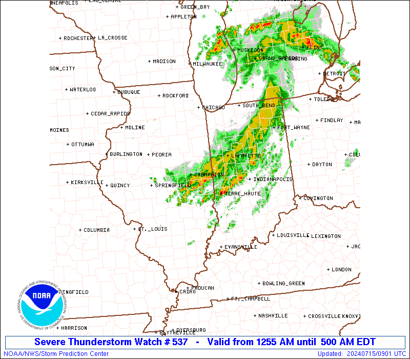
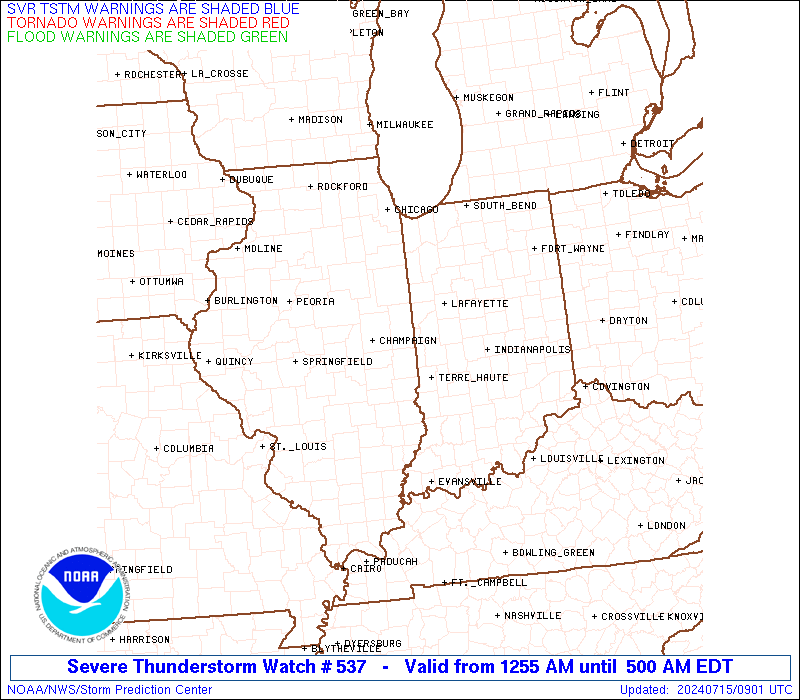
Severe Thunderstorm Watch Number 537
NWS Storm Prediction Center Norman OK
1255 AM EDT Mon Jul 15 2024
The NWS Storm Prediction Center has issued a
* Severe Thunderstorm Watch for portions of
Central Illinois
Central Indiana
* Effective this Monday morning from 1255 AM until 500 AM EDT.
* Primary threats include...
Scattered damaging wind gusts to 70 mph likely
A tornado or two possible
SUMMARY...A cluster of thunderstorms should continue to move
southeastward through the early morning hours while posing some
threat for mainly severe/damaging winds up to 60-70 mph.
The severe thunderstorm watch area is approximately along and 30
statute miles north and south of a line from 10 miles west of
Decatur IL to 35 miles northeast of Indianapolis IN. For a complete
depiction of the watch see the associated watch outline update
(WOUS64 KWNS WOU7).
PRECAUTIONARY/PREPAREDNESS ACTIONS...
REMEMBER...A Severe Thunderstorm Watch means conditions are
favorable for severe thunderstorms in and close to the watch area.
Persons in these areas should be on the lookout for threatening
weather conditions and listen for later statements and possible
warnings. Severe thunderstorms can and occasionally do produce
tornadoes.
&&
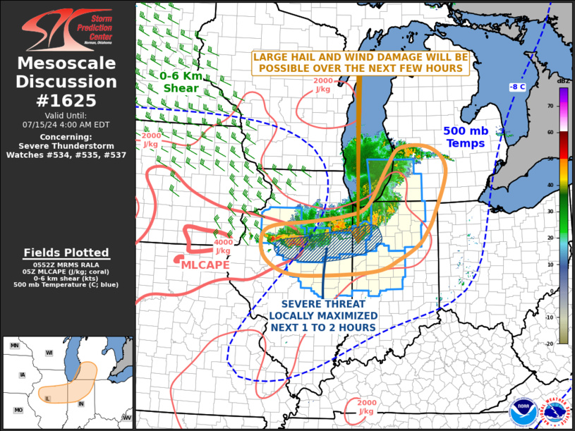
OTHER WATCH INFORMATION...CONTINUE...WW 533...WW 534...WW
535...WW 536...
AVIATION...A few severe thunderstorms with hail surface and aloft to
1 inch. Extreme turbulence and surface wind gusts to 60 knots. A few
cumulonimbi with maximum tops to 500. Mean storm motion vector
30035.
...Gleason
 Note:
The Aviation Watch (SAW) product is an approximation to the watch area.
The actual watch is depicted by the shaded areas.
Note:
The Aviation Watch (SAW) product is an approximation to the watch area.
The actual watch is depicted by the shaded areas.
   SAW7
   WW 537 SEVERE TSTM IL IN 150455Z - 150900Z
   AXIS..30 STATUTE MILES NORTH AND SOUTH OF LINE..
   10W DEC/DECATUR IL/ - 35NE IND/INDIANAPOLIS IN/
   ..AVIATION COORDS.. 25NM N/S /11WNW AXC - 30ENE IND/
   HAIL SURFACE AND ALOFT..1 INCH. WIND GUSTS..60 KNOTS.
   MAX TOPS TO 500. MEAN STORM MOTION VECTOR 30035.

   LAT...LON 40258906 40508581 39648581 39408906

   THIS IS AN APPROXIMATION TO THE WATCH AREA.  FOR A
   COMPLETE DEPICTION OF THE WATCH SEE WOUS64 KWNS
   FOR WOU7.
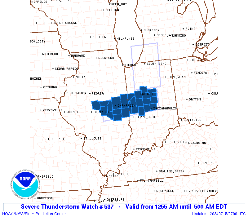
Watch 537 Status Report Messages:
STATUS REPORT #3 ON WW 537
VALID 150840Z - 150940Z
SEVERE WEATHER THREAT CONTINUES RIGHT OF A LINE FROM 10 ESE PIA
TO 5 WSW CMI TO 25 S LAF TO 20 SE LAF TO 45 ENE LAF.
..BROYLES..07/15/24
ATTN...WFO...ILX...IND...
&&
STATUS REPORT FOR WS 537
SEVERE WEATHER THREAT CONTINUES FOR THE FOLLOWING AREAS
ILC029-039-041-045-107-115-139-147-150940-
IL
. ILLINOIS COUNTIES INCLUDED ARE
COLES DE WITT DOUGLAS
EDGAR LOGAN MACON
MOULTRIE PIATT
$$
INC011-023-057-063-067-097-107-121-133-159-165-150940-
IN
. INDIANA COUNTIES INCLUDED ARE
BOONE CLINTON HAMILTON
HENDRICKS HOWARD MARION
MONTGOMERY PARKE PUTNAM
TIPTON VERMILLION
$$
THE WATCH STATUS MESSAGE IS FOR GUIDANCE PURPOSES ONLY. PLEASE
REFER TO WATCH COUNTY NOTIFICATION STATEMENTS FOR OFFICIAL
INFORMATION ON COUNTIES...INDEPENDENT CITIES AND MARINE ZONES
CLEARED FROM SEVERE THUNDERSTORM AND TORNADO WATCHES.
$$
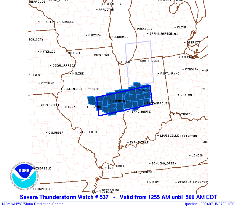
STATUS REPORT #2 ON WW 537
VALID 150745Z - 150840Z
THE SEVERE WEATHER THREAT CONTINUES ACROSS THE ENTIRE WATCH AREA.
..BROYLES..07/15/24
ATTN...WFO...ILX...IND...
&&
STATUS REPORT FOR WS 537
SEVERE WEATHER THREAT CONTINUES FOR THE FOLLOWING AREAS
ILC019-029-039-041-045-107-115-139-147-183-150840-
IL
. ILLINOIS COUNTIES INCLUDED ARE
CHAMPAIGN COLES DE WITT
DOUGLAS EDGAR LOGAN
MACON MOULTRIE PIATT
VERMILION
$$
INC011-015-023-045-057-063-067-097-107-121-133-157-159-165-171-
150840-
IN
. INDIANA COUNTIES INCLUDED ARE
BOONE CARROLL CLINTON
FOUNTAIN HAMILTON HENDRICKS
HOWARD MARION MONTGOMERY
PARKE PUTNAM TIPPECANOE
TIPTON VERMILLION WARREN
$$
THE WATCH STATUS MESSAGE IS FOR GUIDANCE PURPOSES ONLY. PLEASE
REFER TO WATCH COUNTY NOTIFICATION STATEMENTS FOR OFFICIAL
INFORMATION ON COUNTIES...INDEPENDENT CITIES AND MARINE ZONES
CLEARED FROM SEVERE THUNDERSTORM AND TORNADO WATCHES.
$$
STATUS REPORT #1 ON WW 537
VALID 150705Z - 150840Z
THE SEVERE WEATHER THREAT CONTINUES ACROSS THE ENTIRE WATCH AREA.
..BROYLES..07/15/24
ATTN...WFO...ILX...IND...
&&
STATUS REPORT FOR WS 537
SEVERE WEATHER THREAT CONTINUES FOR THE FOLLOWING AREAS
ILC019-029-039-041-045-107-115-139-147-183-150840-
IL
. ILLINOIS COUNTIES INCLUDED ARE
CHAMPAIGN COLES DE WITT
DOUGLAS EDGAR LOGAN
MACON MOULTRIE PIATT
VERMILION
$$
INC011-015-023-045-057-063-067-097-107-121-133-157-159-165-171-
150840-
IN
. INDIANA COUNTIES INCLUDED ARE
BOONE CARROLL CLINTON
FOUNTAIN HAMILTON HENDRICKS
HOWARD MARION MONTGOMERY
PARKE PUTNAM TIPPECANOE
TIPTON VERMILLION WARREN
$$
THE WATCH STATUS MESSAGE IS FOR GUIDANCE PURPOSES ONLY. PLEASE
REFER TO WATCH COUNTY NOTIFICATION STATEMENTS FOR OFFICIAL
INFORMATION ON COUNTIES...INDEPENDENT CITIES AND MARINE ZONES
CLEARED FROM SEVERE THUNDERSTORM AND TORNADO WATCHES.
$$
Note:
Click for Complete Product Text.
Tornadoes
Probability of 2 or more tornadoes
|
Low (20%)
|
Probability of 1 or more strong (EF2-EF5) tornadoes
|
Low (10%)
|
Wind
Probability of 10 or more severe wind events
|
Mod (60%)
|
Probability of 1 or more wind events > 65 knots
|
Low (20%)
|
Hail
Probability of 10 or more severe hail events
|
Low (10%)
|
Probability of 1 or more hailstones > 2 inches
|
Low (<5%)
|
Combined Severe Hail/Wind
Probability of 6 or more combined severe hail/wind events
|
High (70%)
|
For each watch, probabilities for particular events inside the watch
(listed above in each table) are determined by the issuing forecaster.
The "Low" category contains probability values ranging from less than 2%
to 20% (EF2-EF5 tornadoes), less than 5% to 20% (all other probabilities),
"Moderate" from 30% to 60%, and "High" from 70% to greater than 95%.
High values are bolded and lighter in color to provide awareness of
an increased threat for a particular event.


 @NWSSPC