Mesoscale Discussion 1625
NWS Storm Prediction Center Norman OK
1254 AM CDT Mon Jul 15 2024
Areas affected...Northern Illinois...Northern Indiana...Southwest
Michigan
Concerning...Severe Thunderstorm Watch 534...535...537...
Valid 150554Z - 150800Z
The severe weather threat for Severe Thunderstorm Watch 534, 535,
537 continues.
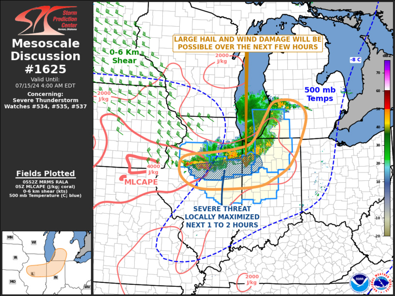
SUMMARY...A wind-damage and large-hail threat is expected to
continue over the next few hours across parts of northern Illinois,
northern Indiana and southwest Lower Michigan. As the severe threat
moves southeastward, WW 535 may need to be extended eastward.
DISCUSSION...The latest hi-resolution radar imagery shows a linear
MCS in northern Illinois and northwestern Indiana, which is located
along and just to the north of an east-to-west axis of instability.
Along this axis, MLCAPE is estimated by the RAP in the 2500 to 3500
J/kg range. In addition to the instability, the line of strong to
severe storms is being supported by a shortwave trough, evident on
water-vapor imagery. Ahead of the shortwave trough, the RAP has
moderate deep-layer shear across much of the southern Great Lakes
region. The Lincoln, Illinois WSR-88D VWP has 0-6 km shear around 50
knots, suggesting that a severe threat will continue in the vicinity
over the next few hours. Large hail and wind damage will be the
primary threats, although low-level shear on forecast soundings is
strong enough for a brief tornado as well.
..Broyles.. 07/15/2024
...Please see www.spc.noaa.gov for graphic product...
ATTN...WFO...IWX...GRR...IND...LOT...ILX...DVN...
LAT...LON 41658702 41418771 41278879 41139008 40859043 40349030
40008958 39958841 40078676 40358601 40688542 40968517
41418489 42518450 43058502 43048597 42598639 41658702
|


 @NWSSPC