 Note:
The expiration time in the watch graphic is amended if the watch is
replaced, cancelled or extended.
Note:
Note:
The expiration time in the watch graphic is amended if the watch is
replaced, cancelled or extended.
Note: Click for
Watch Status Reports.
SEL4
URGENT - IMMEDIATE BROADCAST REQUESTED
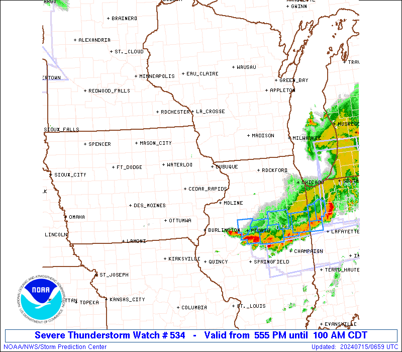
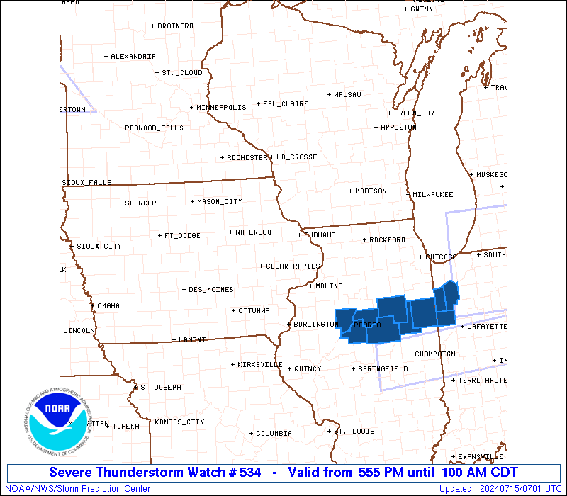
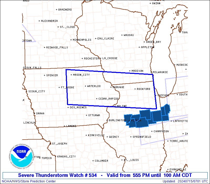
Severe Thunderstorm Watch Number 534
NWS Storm Prediction Center Norman OK
555 PM CDT Sun Jul 14 2024
The NWS Storm Prediction Center has issued a
* Severe Thunderstorm Watch for portions of
Northern and Eastern Iowa
Northern Illinois
Far Northwest Indiana
Southern Wisconsin
Lake Michigan
* Effective this Sunday afternoon and Monday morning from 555 PM
until 100 AM CDT.
* Primary threats include...
Scattered damaging wind gusts to 70 mph likely
Isolated very large hail events to 2 inches in diameter possible
A tornado or two possible
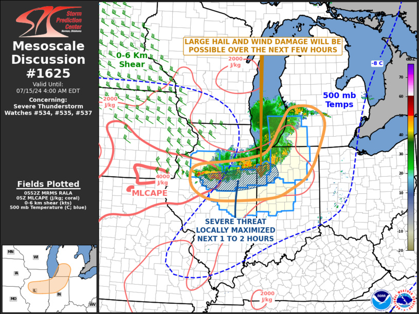
SUMMARY...Thunderstorms are expected to continue increasing in
coverage and intensity this evening. Isolated large hail generally
1-1.75 inches in diameter may occur with the initially more cellular
activity. With time, a bowing cluster of thunderstorms should pose a
greater threat for severe/damaging winds up to around 60-70 mph. A
landspout tornado or two also appears possible.
The severe thunderstorm watch area is approximately along and 60
statute miles north and south of a line from 45 miles south
southwest of Mason City IA to 55 miles south of Racine WI. For a
complete depiction of the watch see the associated watch outline
update (WOUS64 KWNS WOU4).
PRECAUTIONARY/PREPAREDNESS ACTIONS...
REMEMBER...A Severe Thunderstorm Watch means conditions are
favorable for severe thunderstorms in and close to the watch area.
Persons in these areas should be on the lookout for threatening
weather conditions and listen for later statements and possible
warnings. Severe thunderstorms can and occasionally do produce
tornadoes.
&&
OTHER WATCH INFORMATION...CONTINUE...WW 533...
AVIATION...A few severe thunderstorms with hail surface and aloft to
2 inches. Extreme turbulence and surface wind gusts to 60 knots. A
few cumulonimbi with maximum tops to 500. Mean storm motion vector
28030.
...Gleason

   SEL4

   URGENT - IMMEDIATE BROADCAST REQUESTED
   Severe Thunderstorm Watch Number 534
   NWS Storm Prediction Center Norman OK
   555 PM CDT Sun Jul 14 2024

   The NWS Storm Prediction Center has issued a

   * Severe Thunderstorm Watch for portions of
     Northern and Eastern Iowa
     Northern Illinois
     Far Northwest Indiana
     Southern Wisconsin
     Lake Michigan

   * Effective this Sunday afternoon and Monday morning from 555 PM
     until 100 AM CDT.

   * Primary threats include...
     Scattered damaging wind gusts to 70 mph likely
     Isolated very large hail events to 2 inches in diameter possible
     A tornado or two possible

   SUMMARY...Thunderstorms are expected to continue increasing in
   coverage and intensity this evening. Isolated large hail generally
   1-1.75 inches in diameter may occur with the initially more cellular
   activity. With time, a bowing cluster of thunderstorms should pose a
   greater threat for severe/damaging winds up to around 60-70 mph. A
   landspout tornado or two also appears possible.

   The severe thunderstorm watch area is approximately along and 60
   statute miles north and south of a line from 45 miles south
   southwest of Mason City IA to 55 miles south of Racine WI. For a
   complete depiction of the watch see the associated watch outline
   update (WOUS64 KWNS WOU4).

   PRECAUTIONARY/PREPAREDNESS ACTIONS...

   REMEMBER...A Severe Thunderstorm Watch means conditions are
   favorable for severe thunderstorms in and close to the watch area.
   Persons in these areas should be on the lookout for threatening
   weather conditions and listen for later statements and possible
   warnings. Severe thunderstorms can and occasionally do produce
   tornadoes.

   &&

   OTHER WATCH INFORMATION...CONTINUE...WW 533...

   AVIATION...A few severe thunderstorms with hail surface and aloft to
   2 inches. Extreme turbulence and surface wind gusts to 60 knots. A
   few cumulonimbi with maximum tops to 500. Mean storm motion vector
   28030.

   ...Gleason
 Note:
The Aviation Watch (SAW) product is an approximation to the watch area.
The actual watch is depicted by the shaded areas.
Note:
The Aviation Watch (SAW) product is an approximation to the watch area.
The actual watch is depicted by the shaded areas.
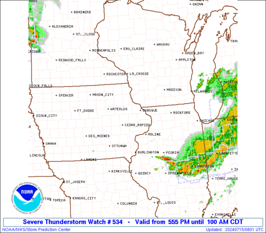
   SAW4
   WW 534 SEVERE TSTM IA IL IN WI LM 142255Z - 150600Z
   AXIS..60 STATUTE MILES NORTH AND SOUTH OF LINE..
   45SSW MCW/MASON CITY IA/ - 55S RAC/RACINE WI/
   ..AVIATION COORDS.. 50NM N/S /28E FOD - 4ESE ORD/
   HAIL SURFACE AND ALOFT..2 INCHES. WIND GUSTS..60 KNOTS.
   MAX TOPS TO 500. MEAN STORM MOTION VECTOR 28030.

   LAT...LON 43429367 42838781 41108781 41689367

   THIS IS AN APPROXIMATION TO THE WATCH AREA.  FOR A
   COMPLETE DEPICTION OF THE WATCH SEE WOUS64 KWNS
   FOR WOU4.
Watch 534 Status Report Messages:
STATUS REPORT #5 ON WW 534

VALID 150430Z - 150540Z

SEVERE WEATHER THREAT CONTINUES RIGHT OF A LINE FROM 15 W MLI TO
35 SSW RFD TO 45 WNW VPZ.

FOR ADDITIONAL INFORMATION SEE MESOSCALE DISCUSSION 1624.

..GRAMS..07/15/24

ATTN...WFO...DVN...DMX...ARX...LOT...ILX...MKX...

&&

STATUS REPORT FOR WS 534

SEVERE WEATHER THREAT CONTINUES FOR THE FOLLOWING AREAS

ILC011-053-063-073-075-091-093-095-099-105-123-143-155-175-197-
203-150540-

IL
.    ILLINOIS COUNTIES INCLUDED ARE

BUREAU		     FORD		 GRUNDY
HENRY		     IROQUOIS		 KANKAKEE
KENDALL 	     KNOX		 LA SALLE
LIVINGSTON	     MARSHALL		 PEORIA
PUTNAM		     STARK		 WILL
WOODFORD
$$


INC073-089-111-127-150540-

IN
.    INDIANA COUNTIES INCLUDED ARE

JASPER		     LAKE		 NEWTON
PORTER
$$


LMZ743-744-745-150540-

CW

.    ADJACENT COASTAL WATERS INCLUDED ARE

CALUMET HARBOR IL TO GARY IN

GARY TO BURNS HARBOR IN

BURNS HARBOR TO MICHIGAN CITY IN

$$
THE WATCH STATUS MESSAGE IS FOR GUIDANCE PURPOSES ONLY.  PLEASE
REFER TO WATCH COUNTY NOTIFICATION STATEMENTS FOR OFFICIAL
INFORMATION ON COUNTIES...INDEPENDENT CITIES AND MARINE ZONES
CLEARED FROM SEVERE THUNDERSTORM AND TORNADO WATCHES.
$$

STATUS REPORT #4 ON WW 534

VALID 150335Z - 150440Z

SEVERE WEATHER THREAT CONTINUES RIGHT OF A LINE FROM 35 W MLI TO
40 ESE DBQ TO 35 SE RFD TO 15 WSW MKE.

..GRAMS..07/15/24

ATTN...WFO...DVN...DMX...ARX...LOT...ILX...MKX...

&&

STATUS REPORT FOR WS 534

SEVERE WEATHER THREAT CONTINUES FOR THE FOLLOWING AREAS

ILC011-015-031-037-043-063-073-089-091-093-097-099-103-105-123-
141-155-161-175-195-197-150440-

IL
.    ILLINOIS COUNTIES INCLUDED ARE

BUREAU		     CARROLL		 COOK
DE KALB 	     DUPAGE		 GRUNDY
HENRY		     KANE		 KANKAKEE
KENDALL 	     LAKE		 LA SALLE
LEE		     LIVINGSTON 	 MARSHALL
OGLE		     PUTNAM		 ROCK ISLAND
STARK		     WHITESIDE		 WILL
$$


INC089-150440-

IN
.    INDIANA COUNTIES INCLUDED ARE

LAKE
$$


IAC045-163-150440-

IA
.    IOWA COUNTIES INCLUDED ARE

CLINTON 	     SCOTT
$$


WIC059-101-150440-

WI
.    WISCONSIN COUNTIES INCLUDED ARE

KENOSHA 	     RACINE
$$


LMZ645-646-740-741-742-743-744-150440-

CW

.    ADJACENT COASTAL WATERS INCLUDED ARE

NORTH POINT LIGHT TO WIND POINT WI

WIND POINT WI TO WINTHROP HARBOR IL

WINTHROP HARBOR TO WILMETTE HARBOR IL

WILMETTE HARBOR TO NORTHERLY ISLAND IL

NORTHERLY ISLAND TO CALUMET HARBOR IL

CALUMET HARBOR IL TO GARY IN

GARY TO BURNS HARBOR IN

$$
THE WATCH STATUS MESSAGE IS FOR GUIDANCE PURPOSES ONLY.  PLEASE
REFER TO WATCH COUNTY NOTIFICATION STATEMENTS FOR OFFICIAL
INFORMATION ON COUNTIES...INDEPENDENT CITIES AND MARINE ZONES
CLEARED FROM SEVERE THUNDERSTORM AND TORNADO WATCHES.
$$

STATUS REPORT #3 ON WW 534

VALID 150300Z - 150440Z

SEVERE WEATHER THREAT CONTINUES RIGHT OF A LINE FROM 35 SE CID TO
35 SSW DBQ TO 5 ESE DBQ TO 15 SW RFD TO 20 E RFD TO 30 NE JVL.

..SPC..07/15/24

ATTN...WFO...DVN...DMX...ARX...LOT...ILX...MKX...

&&

STATUS REPORT FOR WS 534

SEVERE WEATHER THREAT CONTINUES FOR THE FOLLOWING AREAS

ILC011-015-031-037-043-063-073-089-091-093-097-099-103-105-111-
123-141-155-161-175-195-197-150440-

IL
.    ILLINOIS COUNTIES INCLUDED ARE

BUREAU		     CARROLL		 COOK
DE KALB 	     DUPAGE		 GRUNDY
HENRY		     KANE		 KANKAKEE
KENDALL 	     LAKE		 LA SALLE
LEE		     LIVINGSTON 	 MCHENRY
MARSHALL	     OGLE		 PUTNAM
ROCK ISLAND	     STARK		 WHITESIDE
WILL
$$


INC089-150440-

IN
.    INDIANA COUNTIES INCLUDED ARE

LAKE
$$


IAC031-045-097-139-163-150440-

IA
.    IOWA COUNTIES INCLUDED ARE

CEDAR		     CLINTON		 JACKSON
MUSCATINE	     SCOTT
$$


WIC059-079-101-127-133-150440-

WI
.    WISCONSIN COUNTIES INCLUDED ARE

KENOSHA 	     MILWAUKEE		 RACINE
WALWORTH	     WAUKESHA
$$


LMZ645-646-740-741-742-743-744-150440-

CW

.    ADJACENT COASTAL WATERS INCLUDED ARE

NORTH POINT LIGHT TO WIND POINT WI

WIND POINT WI TO WINTHROP HARBOR IL

WINTHROP HARBOR TO WILMETTE HARBOR IL

WILMETTE HARBOR TO NORTHERLY ISLAND IL

NORTHERLY ISLAND TO CALUMET HARBOR IL

CALUMET HARBOR IL TO GARY IN

GARY TO BURNS HARBOR IN

$$
THE WATCH STATUS MESSAGE IS FOR GUIDANCE PURPOSES ONLY.  PLEASE
REFER TO WATCH COUNTY NOTIFICATION STATEMENTS FOR OFFICIAL
INFORMATION ON COUNTIES...INDEPENDENT CITIES AND MARINE ZONES
CLEARED FROM SEVERE THUNDERSTORM AND TORNADO WATCHES.
$$

STATUS REPORT #2 ON WW 534

VALID 150140Z - 150240Z

SEVERE WEATHER THREAT CONTINUES RIGHT OF A LINE FROM 25 NE OXV TO
20 NNW DBQ TO 20 SE LNR.

..SPC..07/15/24

ATTN...WFO...DVN...DMX...ARX...LOT...ILX...MKX...

&&

STATUS REPORT FOR WS 534

SEVERE WEATHER THREAT CONTINUES FOR THE FOLLOWING AREAS

ILC007-011-015-031-037-043-063-073-085-089-091-093-097-099-103-
105-111-123-141-155-161-175-177-195-197-201-150240-

IL
.    ILLINOIS COUNTIES INCLUDED ARE

BOONE		     BUREAU		 CARROLL
COOK		     DE KALB		 DUPAGE
GRUNDY		     HENRY		 JO DAVIESS
KANE		     KANKAKEE		 KENDALL
LAKE		     LA SALLE		 LEE
LIVINGSTON	     MCHENRY		 MARSHALL
OGLE		     PUTNAM		 ROCK ISLAND
STARK		     STEPHENSON 	 WHITESIDE
WILL		     WINNEBAGO
$$


INC089-150240-

IN
.    INDIANA COUNTIES INCLUDED ARE

LAKE
$$


IAC031-045-061-095-097-103-105-113-139-157-163-150240-

IA
.    IOWA COUNTIES INCLUDED ARE

CEDAR		     CLINTON		 DUBUQUE
IOWA		     JACKSON		 JOHNSON
JONES		     LINN		 MUSCATINE
POWESHIEK	     SCOTT
$$


WIC025-027-043-045-049-055-059-065-079-101-105-127-133-150240-

WI
.    WISCONSIN COUNTIES INCLUDED ARE

DANE		     DODGE		 GRANT
GREEN		     IOWA		 JEFFERSON
KENOSHA 	     LAFAYETTE		 MILWAUKEE
RACINE		     ROCK		 WALWORTH
WAUKESHA
$$


LMZ645-646-740-741-742-743-744-150240-

CW

.    ADJACENT COASTAL WATERS INCLUDED ARE

NORTH POINT LIGHT TO WIND POINT WI

WIND POINT WI TO WINTHROP HARBOR IL

WINTHROP HARBOR TO WILMETTE HARBOR IL

WILMETTE HARBOR TO NORTHERLY ISLAND IL

NORTHERLY ISLAND TO CALUMET HARBOR IL

CALUMET HARBOR IL TO GARY IN

GARY TO BURNS HARBOR IN

$$
THE WATCH STATUS MESSAGE IS FOR GUIDANCE PURPOSES ONLY.  PLEASE
REFER TO WATCH COUNTY NOTIFICATION STATEMENTS FOR OFFICIAL
INFORMATION ON COUNTIES...INDEPENDENT CITIES AND MARINE ZONES
CLEARED FROM SEVERE THUNDERSTORM AND TORNADO WATCHES.
$$

STATUS REPORT #1 ON WW 534

VALID 150055Z - 150140Z

SEVERE WEATHER THREAT CONTINUES RIGHT OF A LINE FROM 25 SW MCW TO
45 ENE ALO TO 25 NNW DBQ TO 20 SE OSH.

..LYONS..07/15/24

ATTN...WFO...DVN...DMX...ARX...LOT...ILX...MKX...

&&

STATUS REPORT FOR WS 534

SEVERE WEATHER THREAT CONTINUES FOR THE FOLLOWING AREAS

ILC007-011-015-031-037-043-063-073-085-089-091-093-097-099-103-
105-111-123-141-155-161-175-177-195-197-201-150140-

IL
.    ILLINOIS COUNTIES INCLUDED ARE

BOONE		     BUREAU		 CARROLL
COOK		     DE KALB		 DUPAGE
GRUNDY		     HENRY		 JO DAVIESS
KANE		     KANKAKEE		 KENDALL
LAKE		     LA SALLE		 LEE
LIVINGSTON	     MCHENRY		 MARSHALL
OGLE		     PUTNAM		 ROCK ISLAND
STARK		     STEPHENSON 	 WHITESIDE
WILL		     WINNEBAGO
$$


INC089-150140-

IN
.    INDIANA COUNTIES INCLUDED ARE

LAKE
$$


IAC011-013-017-019-023-031-045-055-061-069-075-083-095-097-103-
105-113-127-139-157-163-171-197-150140-

IA
.    IOWA COUNTIES INCLUDED ARE

BENTON		     BLACK HAWK 	 BREMER
BUCHANAN	     BUTLER		 CEDAR
CLINTON 	     DELAWARE		 DUBUQUE
FRANKLIN	     GRUNDY		 HARDIN
IOWA		     JACKSON		 JOHNSON
JONES		     LINN		 MARSHALL
MUSCATINE	     POWESHIEK		 SCOTT
TAMA		     WRIGHT
$$


WIC025-027-043-045-049-055-059-065-079-101-105-127-133-150140-

WI
.    WISCONSIN COUNTIES INCLUDED ARE

DANE		     DODGE		 GRANT
GREEN		     IOWA		 JEFFERSON
KENOSHA 	     LAFAYETTE		 MILWAUKEE
RACINE		     ROCK		 WALWORTH
WAUKESHA
$$


LMZ645-646-740-741-742-743-744-150140-

CW

.    ADJACENT COASTAL WATERS INCLUDED ARE

NORTH POINT LIGHT TO WIND POINT WI

WIND POINT WI TO WINTHROP HARBOR IL

WINTHROP HARBOR TO WILMETTE HARBOR IL

WILMETTE HARBOR TO NORTHERLY ISLAND IL

NORTHERLY ISLAND TO CALUMET HARBOR IL

CALUMET HARBOR IL TO GARY IN

GARY TO BURNS HARBOR IN

$$
THE WATCH STATUS MESSAGE IS FOR GUIDANCE PURPOSES ONLY.  PLEASE
REFER TO WATCH COUNTY NOTIFICATION STATEMENTS FOR OFFICIAL
INFORMATION ON COUNTIES...INDEPENDENT CITIES AND MARINE ZONES
CLEARED FROM SEVERE THUNDERSTORM AND TORNADO WATCHES.
$$
Note:
Click for Complete Product Text.
Tornadoes
Probability of 2 or more tornadoes
|
Low (20%)
|
Probability of 1 or more strong (EF2-EF5) tornadoes
|
Low (10%)
|
Wind
Probability of 10 or more severe wind events
|
Mod (60%)
|
Probability of 1 or more wind events > 65 knots
|
Low (20%)
|
Hail
Probability of 10 or more severe hail events
|
Mod (30%)
|
Probability of 1 or more hailstones > 2 inches
|
Mod (30%)
|
Combined Severe Hail/Wind
Probability of 6 or more combined severe hail/wind events
|
High (80%)
|
For each watch, probabilities for particular events inside the watch
(listed above in each table) are determined by the issuing forecaster.
The "Low" category contains probability values ranging from less than 2%
to 20% (EF2-EF5 tornadoes), less than 5% to 20% (all other probabilities),
"Moderate" from 30% to 60%, and "High" from 70% to greater than 95%.
High values are bolded and lighter in color to provide awareness of
an increased threat for a particular event.


 @NWSSPC