 Note:
The expiration time in the watch graphic is amended if the watch is
replaced, cancelled or extended.
Note:
Note:
The expiration time in the watch graphic is amended if the watch is
replaced, cancelled or extended.
Note: Click for
Watch Status Reports.
SEL3
URGENT - IMMEDIATE BROADCAST REQUESTED
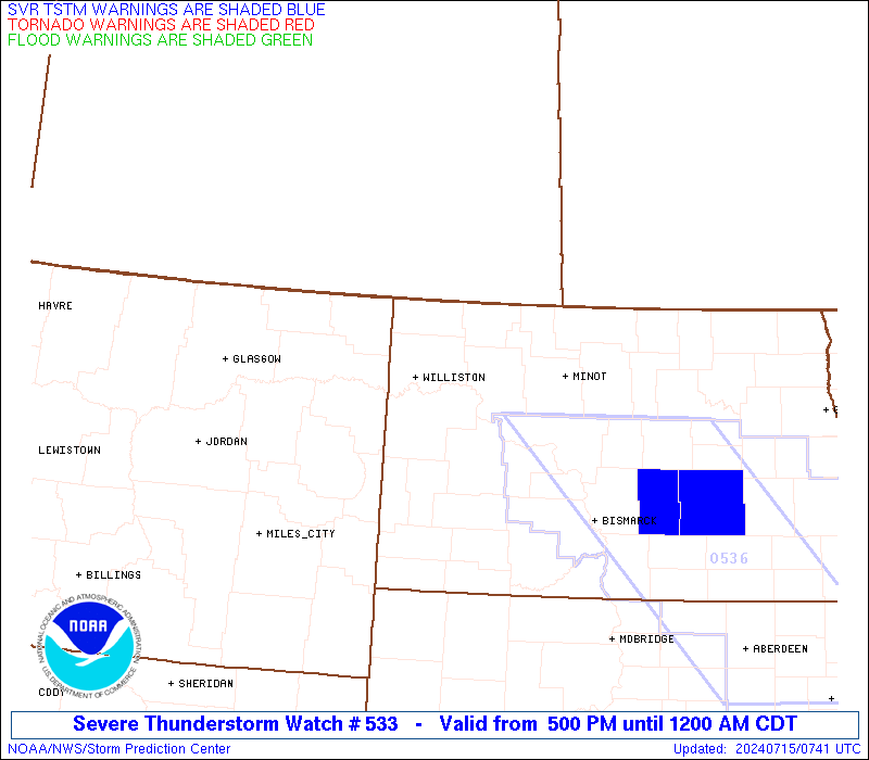
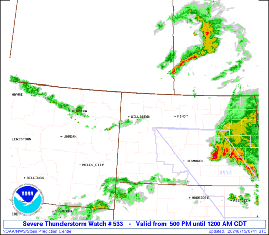
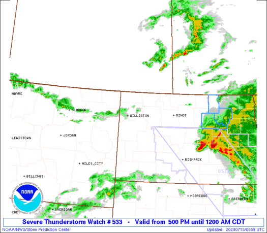
Severe Thunderstorm Watch Number 533
NWS Storm Prediction Center Norman OK
500 PM CDT Sun Jul 14 2024
The NWS Storm Prediction Center has issued a
* Severe Thunderstorm Watch for portions of
Northeast Montana
Western and Northern North Dakota
* Effective this Sunday afternoon from 500 PM until Midnight CDT.
* Primary threats include...
Scattered large hail likely with isolated very large hail events
to 2.5 inches in diameter possible
Scattered damaging winds and isolated significant gusts to 75
mph possible
A tornado or two possible
SUMMARY...Supercell thunderstorms are expected to develop this
afternoon and evening and move slowly east-southeastward. The most
intense thunderstorms should be capable of producing large to very
large hail around 1.5-2.5 inches in diameter. The potential for
severe/damaging winds is more uncertain. But, if activity can grow
into a bowing cluster later this evening, then peak wind speeds may
reach 65-75 mph.
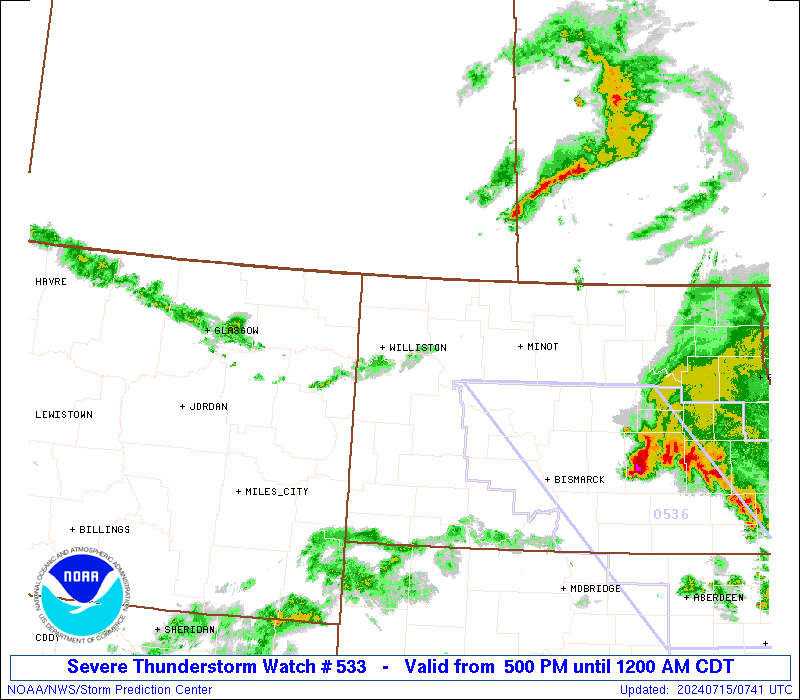
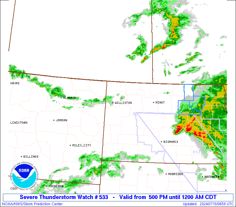
The severe thunderstorm watch area is approximately along and 55
statute miles north and south of a line from 5 miles southwest of
Glasgow MT to 95 miles east of Minot ND. For a complete depiction of
the watch see the associated watch outline update (WOUS64 KWNS
WOU3).
PRECAUTIONARY/PREPAREDNESS ACTIONS...
REMEMBER...A Severe Thunderstorm Watch means conditions are
favorable for severe thunderstorms in and close to the watch area.
Persons in these areas should be on the lookout for threatening
weather conditions and listen for later statements and possible
warnings. Severe thunderstorms can and occasionally do produce
tornadoes.
&&
AVIATION...A few severe thunderstorms with hail surface and aloft to
2.5 inches. Extreme turbulence and surface wind gusts to 65 knots. A
few cumulonimbi with maximum tops to 500. Mean storm motion vector
30025.
...Gleason
   SEL3

   URGENT - IMMEDIATE BROADCAST REQUESTED
   Severe Thunderstorm Watch Number 533
   NWS Storm Prediction Center Norman OK
   500 PM CDT Sun Jul 14 2024

   The NWS Storm Prediction Center has issued a

   * Severe Thunderstorm Watch for portions of
     Northeast Montana
     Western and Northern North Dakota

   * Effective this Sunday afternoon from 500 PM until Midnight CDT.

   * Primary threats include...
     Scattered large hail likely with isolated very large hail events
       to 2.5 inches in diameter possible
     Scattered damaging winds and isolated significant gusts to 75
       mph possible
     A tornado or two possible

   SUMMARY...Supercell thunderstorms are expected to develop this
   afternoon and evening and move slowly east-southeastward. The most
   intense thunderstorms should be capable of producing large to very
   large hail around 1.5-2.5 inches in diameter. The potential for
   severe/damaging winds is more uncertain. But, if activity can grow
   into a bowing cluster later this evening, then peak wind speeds may
   reach 65-75 mph.

   The severe thunderstorm watch area is approximately along and 55
   statute miles north and south of a line from 5 miles southwest of
   Glasgow MT to 95 miles east of Minot ND. For a complete depiction of
   the watch see the associated watch outline update (WOUS64 KWNS
   WOU3).

   PRECAUTIONARY/PREPAREDNESS ACTIONS...

   REMEMBER...A Severe Thunderstorm Watch means conditions are
   favorable for severe thunderstorms in and close to the watch area.
   Persons in these areas should be on the lookout for threatening
   weather conditions and listen for later statements and possible
   warnings. Severe thunderstorms can and occasionally do produce
   tornadoes.

   &&

   AVIATION...A few severe thunderstorms with hail surface and aloft to
   2.5 inches. Extreme turbulence and surface wind gusts to 65 knots. A
   few cumulonimbi with maximum tops to 500. Mean storm motion vector
   30025.

   ...Gleason
 Note:
The Aviation Watch (SAW) product is an approximation to the watch area.
The actual watch is depicted by the shaded areas.
Note:
The Aviation Watch (SAW) product is an approximation to the watch area.
The actual watch is depicted by the shaded areas.
SAW3
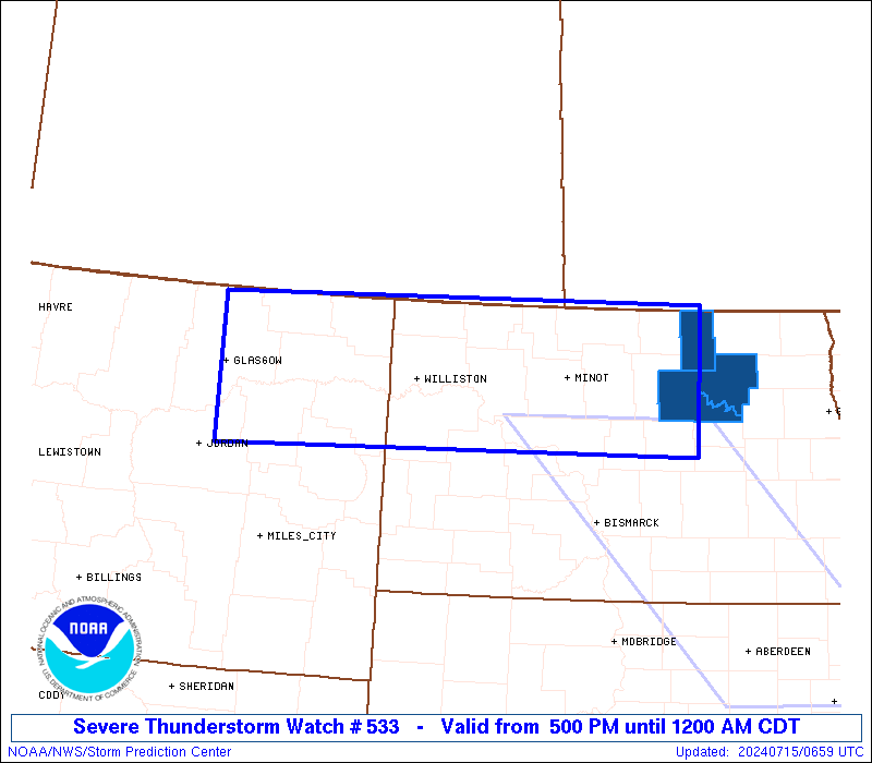
WW 533 SEVERE TSTM MT ND 142200Z - 150500Z
AXIS..55 STATUTE MILES NORTH AND SOUTH OF LINE..
5SW GGW/GLASGOW MT/ - 95E MOT/MINOT ND/
..AVIATION COORDS.. 50NM N/S /4SW GGW - 83E MOT/
HAIL SURFACE AND ALOFT..2.5 INCHES. WIND GUSTS..65 KNOTS.
MAX TOPS TO 500. MEAN STORM MOTION VECTOR 30025.
LAT...LON 48960670 49059921 47469921 47370670
THIS IS AN APPROXIMATION TO THE WATCH AREA. FOR A
COMPLETE DEPICTION OF THE WATCH SEE WOUS64 KWNS
FOR WOU3.
Watch 533 Status Report Messages:
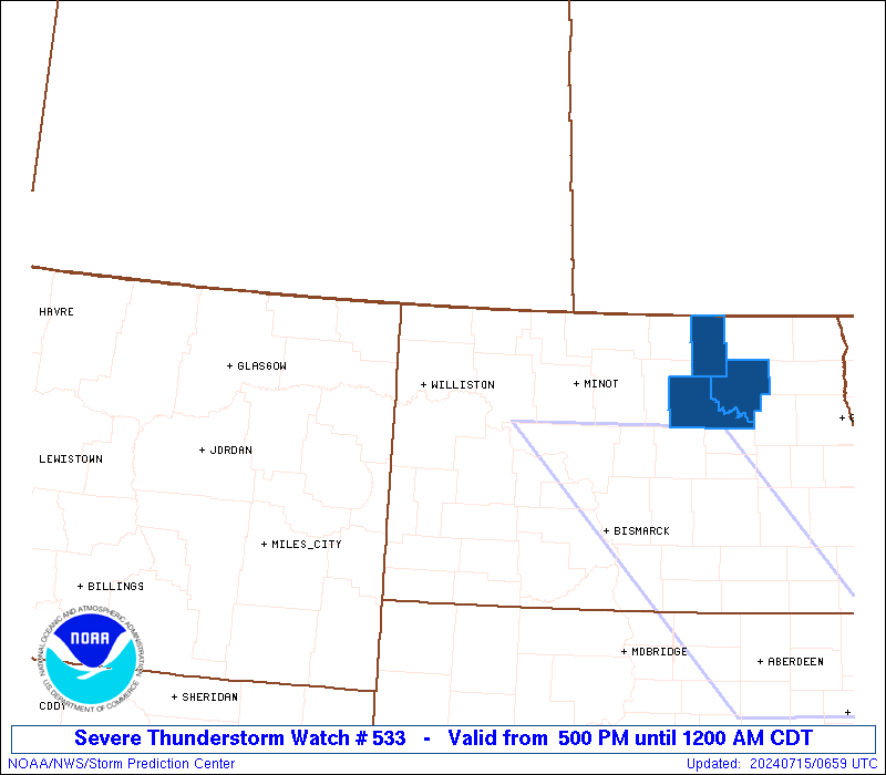
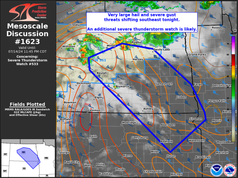
STATUS REPORT #5 ON WW 533

VALID 150335Z - 150440Z

SEVERE WEATHER THREAT CONTINUES RIGHT OF A LINE FROM 40 ESE SDY
TO 25 E ISN TO 55 N MOT.

FOR ADDITIONAL INFORMATION SEE MESOSCALE DISCUSSION 1623.

..GRAMS..07/15/24

ATTN...WFO...GGW...FGF...BIS...

&&

STATUS REPORT FOR WS 533

SEVERE WEATHER THREAT CONTINUES FOR THE FOLLOWING AREAS

NDC005-009-019-025-049-053-055-057-061-065-069-071-075-079-083-
095-101-103-150440-

ND
.    NORTH DAKOTA COUNTIES INCLUDED ARE

BENSON		     BOTTINEAU		 CAVALIER
DUNN		     MCHENRY		 MCKENZIE
MCLEAN		     MERCER		 MOUNTRAIL
OLIVER		     PIERCE		 RAMSEY
RENVILLE	     ROLETTE		 SHERIDAN
TOWNER		     WARD		 WELLS
$$


THE WATCH STATUS MESSAGE IS FOR GUIDANCE PURPOSES ONLY.  PLEASE
REFER TO WATCH COUNTY NOTIFICATION STATEMENTS FOR OFFICIAL
INFORMATION ON COUNTIES...INDEPENDENT CITIES AND MARINE ZONES
CLEARED FROM SEVERE THUNDERSTORM AND TORNADO WATCHES.
$$

STATUS REPORT #4 ON WW 533

VALID 150250Z - 150340Z

SEVERE WEATHER THREAT CONTINUES RIGHT OF A LINE FROM 25 SE SDY TO
10 NE ISN TO 55 N MOT.

FOR ADDITIONAL INFORMATION SEE MESOSCALE DISCUSSION 1623.

..GRAMS..07/15/24

ATTN...WFO...GGW...FGF...BIS...

&&

STATUS REPORT FOR WS 533

SEVERE WEATHER THREAT CONTINUES FOR THE FOLLOWING AREAS

NDC005-007-009-013-019-025-033-049-053-055-057-061-065-069-071-
075-079-083-095-101-103-105-150340-

ND
.    NORTH DAKOTA COUNTIES INCLUDED ARE

BENSON		     BILLINGS		 BOTTINEAU
BURKE		     CAVALIER		 DUNN
GOLDEN VALLEY	     MCHENRY		 MCKENZIE
MCLEAN		     MERCER		 MOUNTRAIL
OLIVER		     PIERCE		 RAMSEY
RENVILLE	     ROLETTE		 SHERIDAN
TOWNER		     WARD		 WELLS
WILLIAMS
$$


THE WATCH STATUS MESSAGE IS FOR GUIDANCE PURPOSES ONLY.  PLEASE
REFER TO WATCH COUNTY NOTIFICATION STATEMENTS FOR OFFICIAL
INFORMATION ON COUNTIES...INDEPENDENT CITIES AND MARINE ZONES
CLEARED FROM SEVERE THUNDERSTORM AND TORNADO WATCHES.
$$

STATUS REPORT #3 ON WW 533

VALID 150140Z - 150240Z

SEVERE WEATHER THREAT CONTINUES RIGHT OF A LINE FROM 20 SSE SDY
TO 60 N ISN.

FOR ADDITIONAL INFORMATION SEE MESOSCALE DISCUSSION 1620.

..GRAMS..07/15/24

ATTN...WFO...GGW...FGF...BIS...

&&

STATUS REPORT FOR WS 533

SEVERE WEATHER THREAT CONTINUES FOR THE FOLLOWING AREAS

NDC005-007-009-013-019-023-025-033-049-053-055-057-061-065-069-
071-075-079-083-095-101-103-105-150240-

ND
.    NORTH DAKOTA COUNTIES INCLUDED ARE

BENSON		     BILLINGS		 BOTTINEAU
BURKE		     CAVALIER		 DIVIDE
DUNN		     GOLDEN VALLEY	 MCHENRY
MCKENZIE	     MCLEAN		 MERCER
MOUNTRAIL	     OLIVER		 PIERCE
RAMSEY		     RENVILLE		 ROLETTE
SHERIDAN	     TOWNER		 WARD
WELLS		     WILLIAMS
$$


THE WATCH STATUS MESSAGE IS FOR GUIDANCE PURPOSES ONLY.  PLEASE
REFER TO WATCH COUNTY NOTIFICATION STATEMENTS FOR OFFICIAL
INFORMATION ON COUNTIES...INDEPENDENT CITIES AND MARINE ZONES
CLEARED FROM SEVERE THUNDERSTORM AND TORNADO WATCHES.
$$

STATUS REPORT #2 ON WW 533

VALID 150055Z - 150140Z

SEVERE WEATHER THREAT CONTINUES RIGHT OF A LINE FROM 25 N BHK TO
80 NNW ISN.

..LYONS..07/15/24

ATTN...WFO...GGW...FGF...BIS...

&&

STATUS REPORT FOR WS 533

SEVERE WEATHER THREAT CONTINUES FOR THE FOLLOWING AREAS

NDC005-007-009-013-019-023-025-033-049-053-055-057-061-065-069-
071-075-079-083-095-101-103-105-150140-

ND
.    NORTH DAKOTA COUNTIES INCLUDED ARE

BENSON		     BILLINGS		 BOTTINEAU
BURKE		     CAVALIER		 DIVIDE
DUNN		     GOLDEN VALLEY	 MCHENRY
MCKENZIE	     MCLEAN		 MERCER
MOUNTRAIL	     OLIVER		 PIERCE
RAMSEY		     RENVILLE		 ROLETTE
SHERIDAN	     TOWNER		 WARD
WELLS		     WILLIAMS
$$


THE WATCH STATUS MESSAGE IS FOR GUIDANCE PURPOSES ONLY.  PLEASE
REFER TO WATCH COUNTY NOTIFICATION STATEMENTS FOR OFFICIAL
INFORMATION ON COUNTIES...INDEPENDENT CITIES AND MARINE ZONES
CLEARED FROM SEVERE THUNDERSTORM AND TORNADO WATCHES.
$$

STATUS REPORT #1 ON WW 533

VALID 142255Z - 142340Z

THE SEVERE WEATHER THREAT CONTINUES ACROSS THE ENTIRE WATCH AREA.

..LYONS..07/14/24

ATTN...WFO...GGW...FGF...BIS...

&&

STATUS REPORT FOR WS 533

SEVERE WEATHER THREAT CONTINUES FOR THE FOLLOWING AREAS

MTC019-021-055-071-083-085-091-105-109-142340-

MT
.    MONTANA COUNTIES INCLUDED ARE

DANIELS 	     DAWSON		 MCCONE
PHILLIPS	     RICHLAND		 ROOSEVELT
SHERIDAN	     VALLEY		 WIBAUX
$$


NDC005-007-009-013-019-023-025-033-049-053-055-057-061-065-069-
071-075-079-083-095-101-103-105-142340-

ND
.    NORTH DAKOTA COUNTIES INCLUDED ARE

BENSON		     BILLINGS		 BOTTINEAU
BURKE		     CAVALIER		 DIVIDE
DUNN		     GOLDEN VALLEY	 MCHENRY
MCKENZIE	     MCLEAN		 MERCER
MOUNTRAIL	     OLIVER		 PIERCE
RAMSEY		     RENVILLE		 ROLETTE
SHERIDAN	     TOWNER		 WARD
WELLS		     WILLIAMS
$$


THE WATCH STATUS MESSAGE IS FOR GUIDANCE PURPOSES ONLY.  PLEASE
REFER TO WATCH COUNTY NOTIFICATION STATEMENTS FOR OFFICIAL
INFORMATION ON COUNTIES...INDEPENDENT CITIES AND MARINE ZONES
CLEARED FROM SEVERE THUNDERSTORM AND TORNADO WATCHES.
$$
Note:
Click for Complete Product Text.
Tornadoes
Probability of 2 or more tornadoes
|
Low (20%)
|
Probability of 1 or more strong (EF2-EF5) tornadoes
|
Low (10%)
|
Wind
Probability of 10 or more severe wind events
|
Mod (50%)
|
Probability of 1 or more wind events > 65 knots
|
Mod (30%)
|
Hail
Probability of 10 or more severe hail events
|
Mod (60%)
|
Probability of 1 or more hailstones > 2 inches
|
Mod (50%)
|
Combined Severe Hail/Wind
Probability of 6 or more combined severe hail/wind events
|
High (90%)
|
For each watch, probabilities for particular events inside the watch
(listed above in each table) are determined by the issuing forecaster.
The "Low" category contains probability values ranging from less than 2%
to 20% (EF2-EF5 tornadoes), less than 5% to 20% (all other probabilities),
"Moderate" from 30% to 60%, and "High" from 70% to greater than 95%.
High values are bolded and lighter in color to provide awareness of
an increased threat for a particular event.


 @NWSSPC