Note:
The expiration time in the watch graphic is amended if the watch is
replaced, cancelled or extended.
Note:
Note:
The expiration time in the watch graphic is amended if the watch is
replaced, cancelled or extended.
Note: Click for
Watch Status Reports.
SEL5
URGENT - IMMEDIATE BROADCAST REQUESTED
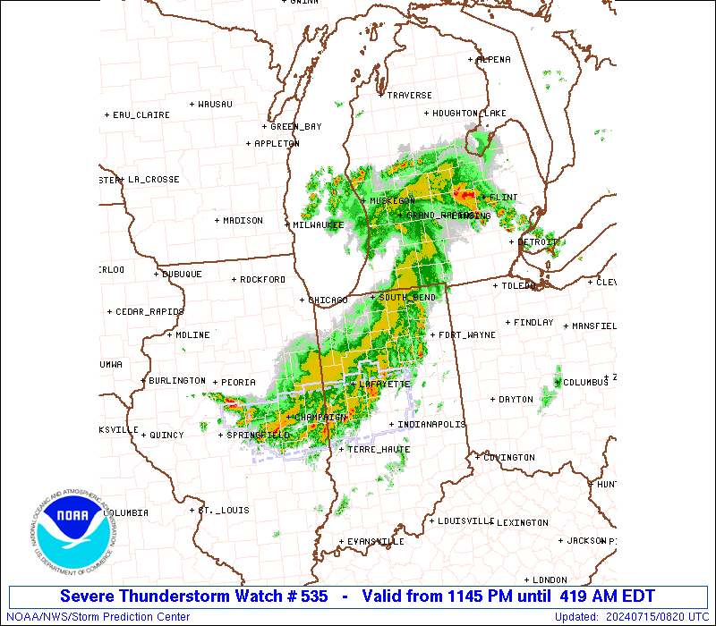
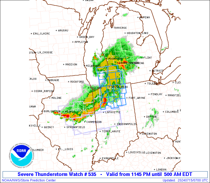
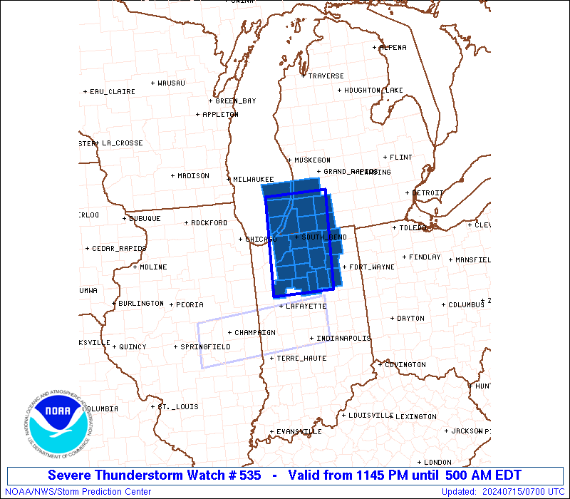
Severe Thunderstorm Watch Number 535
NWS Storm Prediction Center Norman OK
1145 PM EDT Sun Jul 14 2024
The NWS Storm Prediction Center has issued a
* Severe Thunderstorm Watch for portions of
Northern Indiana
Southwest Lower Michigan
Lake Michigan
* Effective this Sunday night and Monday morning from 1145 PM
until 500 AM EDT.
* Primary threats include...
Scattered damaging wind gusts to 70 mph likely
Isolated large hail events to 1 inch in diameter possible
A tornado or two possible
SUMMARY...A small bowing complex of thunderstorms should pose some
threat for damaging winds as it moves east-southeastward through the
early morning hours. Peak gusts may reach up to 60-70 mph in the
most intense portion of the bow.
The severe thunderstorm watch area is approximately along and 40
statute miles east and west of a line from 30 miles north northeast
of Benton Harbor MI to 75 miles south of South Bend IN. For a
complete depiction of the watch see the associated watch outline
update (WOUS64 KWNS WOU5).
PRECAUTIONARY/PREPAREDNESS ACTIONS...
REMEMBER...A Severe Thunderstorm Watch means conditions are
favorable for severe thunderstorms in and close to the watch area.
Persons in these areas should be on the lookout for threatening
weather conditions and listen for later statements and possible
warnings. Severe thunderstorms can and occasionally do produce
tornadoes.
&&
OTHER WATCH INFORMATION...CONTINUE...WW 533...WW 534...
AVIATION...A few severe thunderstorms with hail surface and aloft to
1 inch. Extreme turbulence and surface wind gusts to 60 knots. A few
cumulonimbi with maximum tops to 500. Mean storm motion vector
28035.
...Gleason
 Note:
The Aviation Watch (SAW) product is an approximation to the watch area.
The actual watch is depicted by the shaded areas.
Note:
The Aviation Watch (SAW) product is an approximation to the watch area.
The actual watch is depicted by the shaded areas.
   SAW5
   WW 535 SEVERE TSTM IN MI LM 150345Z - 150900Z
   AXIS..40 STATUTE MILES EAST AND WEST OF LINE..
   30NNE BEH/BENTON HARBOR MI/ - 75S SBN/SOUTH BEND IN/
   ..AVIATION COORDS.. 35NM E/W /6NW PMM - 34E BVT/
   HAIL SURFACE AND ALOFT..1 INCH. WIND GUSTS..60 KNOTS.
   MAX TOPS TO 500. MEAN STORM MOTION VECTOR 28035.

   LAT...LON 42538542 40618556 40618708 42538699

   THIS IS AN APPROXIMATION TO THE WATCH AREA.  FOR A
   COMPLETE DEPICTION OF THE WATCH SEE WOUS64 KWNS
   FOR WOU5.
Watch 535 Status Report Messages:
STATUS REPORT #2 ON WW 535

VALID 150745Z - 150840Z

SEVERE WEATHER THREAT CONTINUES RIGHT OF A LINE FROM 10 NW LAF TO
40 SSE SBN TO 30 S AZO TO 15 SE GRR.

..BROYLES..07/15/24

ATTN...WFO...IWX...GRR...

&&

STATUS REPORT FOR WS 535

SEVERE WEATHER THREAT CONTINUES FOR THE FOLLOWING AREAS

INC017-069-085-103-113-169-181-183-150840-

IN
.    INDIANA COUNTIES INCLUDED ARE

CASS		     HUNTINGTON 	 KOSCIUSKO
MIAMI		     NOBLE		 WABASH
WHITE		     WHITLEY
$$


THE WATCH STATUS MESSAGE IS FOR GUIDANCE PURPOSES ONLY.  PLEASE
REFER TO WATCH COUNTY NOTIFICATION STATEMENTS FOR OFFICIAL
INFORMATION ON COUNTIES...INDEPENDENT CITIES AND MARINE ZONES
CLEARED FROM SEVERE THUNDERSTORM AND TORNADO WATCHES.
$$

STATUS REPORT #1 ON WW 535

VALID 150705Z - 150840Z

SEVERE WEATHER THREAT CONTINUES RIGHT OF A LINE FROM 15 S VPZ TO
15 NNE SBN TO 20 W GRR.

..BROYLES..07/15/24

ATTN...WFO...IWX...GRR...

&&

STATUS REPORT FOR WS 535

SEVERE WEATHER THREAT CONTINUES FOR THE FOLLOWING AREAS

INC017-039-049-069-085-087-099-103-113-131-141-149-169-181-183-
150840-

IN
.    INDIANA COUNTIES INCLUDED ARE

CASS		     ELKHART		 FULTON
HUNTINGTON	     KOSCIUSKO		 LAGRANGE
MARSHALL	     MIAMI		 NOBLE
PULASKI 	     ST. JOSEPH 	 STARKE
WABASH		     WHITE		 WHITLEY
$$


MIC027-077-149-150840-

MI
.    MICHIGAN COUNTIES INCLUDED ARE

CASS		     KALAMAZOO		 ST. JOSEPH
$$


THE WATCH STATUS MESSAGE IS FOR GUIDANCE PURPOSES ONLY.  PLEASE
REFER TO WATCH COUNTY NOTIFICATION STATEMENTS FOR OFFICIAL
INFORMATION ON COUNTIES...INDEPENDENT CITIES AND MARINE ZONES
CLEARED FROM SEVERE THUNDERSTORM AND TORNADO WATCHES.
$$
Note:
Click for Complete Product Text.
Tornadoes
Probability of 2 or more tornadoes
|
Low (20%)
|
Probability of 1 or more strong (EF2-EF5) tornadoes
|
Low (5%)
|
Wind
Probability of 10 or more severe wind events
|
Mod (60%)
|
Probability of 1 or more wind events > 65 knots
|
Low (20%)
|
Hail
Probability of 10 or more severe hail events
|
Low (20%)
|
Probability of 1 or more hailstones > 2 inches
|
Low (10%)
|
Combined Severe Hail/Wind
Probability of 6 or more combined severe hail/wind events
|
High (70%)
|
For each watch, probabilities for particular events inside the watch
(listed above in each table) are determined by the issuing forecaster.
The "Low" category contains probability values ranging from less than 2%
to 20% (EF2-EF5 tornadoes), less than 5% to 20% (all other probabilities),
"Moderate" from 30% to 60%, and "High" from 70% to greater than 95%.
High values are bolded and lighter in color to provide awareness of
an increased threat for a particular event.


 @NWSSPC