 Note:
The expiration time in the watch graphic is amended if the watch is
replaced, cancelled or extended.
Note:
Note:
The expiration time in the watch graphic is amended if the watch is
replaced, cancelled or extended.
Note: Click for
Watch Status Reports.
SEL9
URGENT - IMMEDIATE BROADCAST REQUESTED
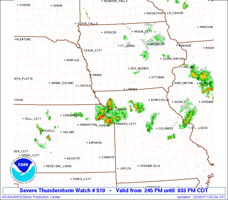
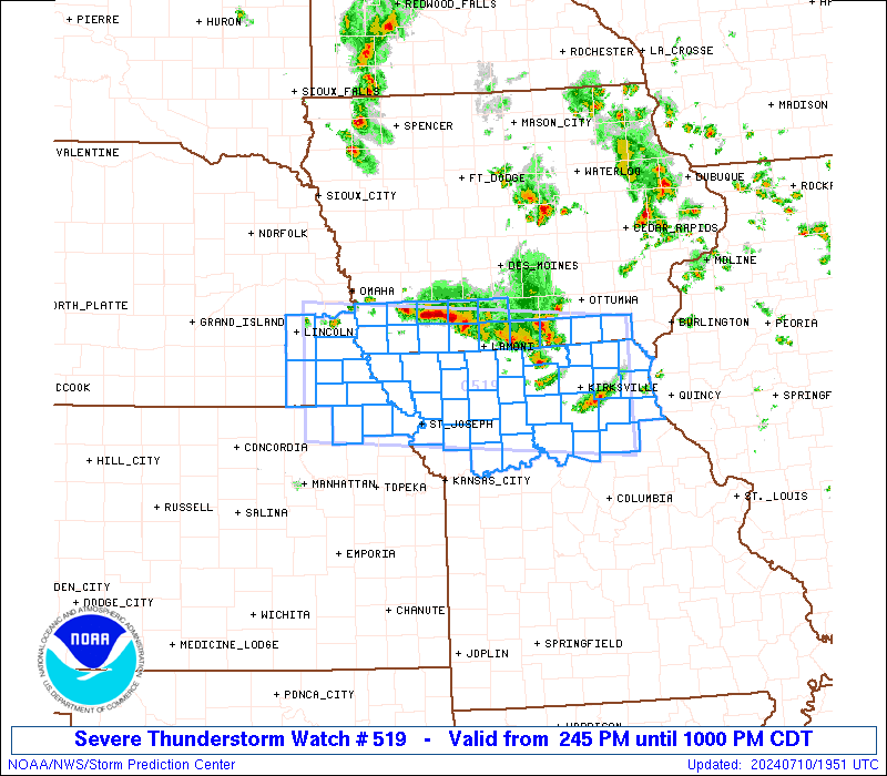
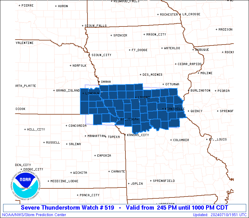
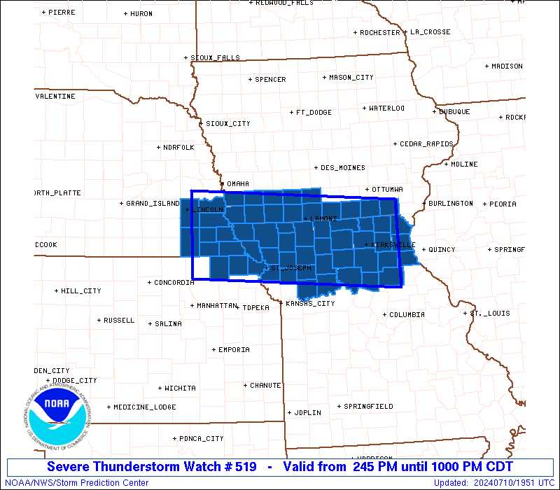
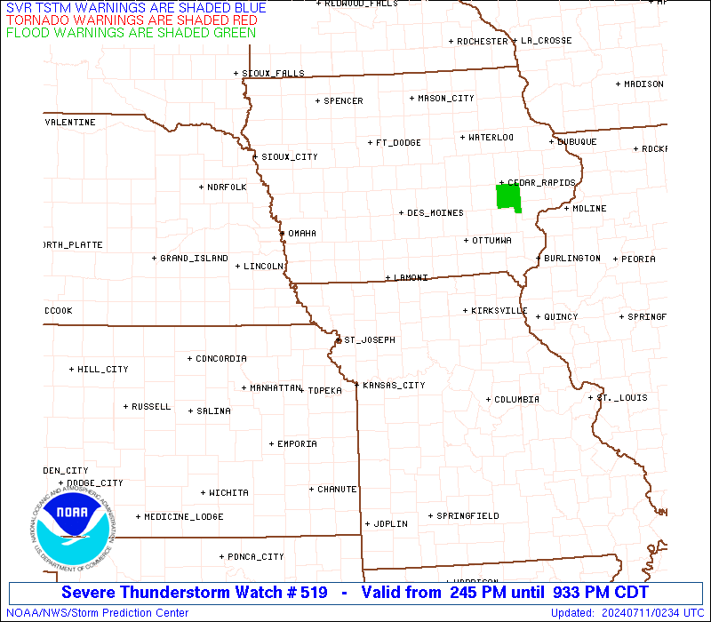
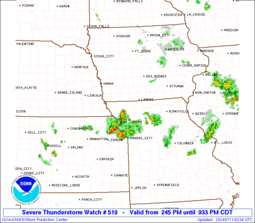
Severe Thunderstorm Watch Number 519
NWS Storm Prediction Center Norman OK
245 PM CDT Wed Jul 10 2024
The NWS Storm Prediction Center has issued a
* Severe Thunderstorm Watch for portions of
Southern Iowa
Northeast Kansas
Northern Missouri
Southeast Nebraska
* Effective this Wednesday afternoon and evening from 245 PM
until 1000 PM CDT.
* Primary threats include...
Scattered damaging wind gusts to 70 mph possible
Scattered large hail events to 1.5 inches in diameter possible
SUMMARY...Clusters of storms and possibly a semi-discrete supercell
or two will spread generally southeastward across the region through
early evening, with severe hail and wind possible.
The severe thunderstorm watch area is approximately along and 55
statute miles north and south of a line from 60 miles west northwest
of Falls City NE to 40 miles east of Kirksville MO. For a complete
depiction of the watch see the associated watch outline update
(WOUS64 KWNS WOU9).
PRECAUTIONARY/PREPAREDNESS ACTIONS...
REMEMBER...A Severe Thunderstorm Watch means conditions are
favorable for severe thunderstorms in and close to the watch area.
Persons in these areas should be on the lookout for threatening
weather conditions and listen for later statements and possible
warnings. Severe thunderstorms can and occasionally do produce
tornadoes.
&&
OTHER WATCH INFORMATION...CONTINUE...WW 517...WW 518...
AVIATION...A few severe thunderstorms with hail surface and aloft to
1.5 inches. Extreme turbulence and surface wind gusts to 60 knots. A
few cumulonimbi with maximum tops to 500. Mean storm motion vector
30025.
...Guyer

   SEL9

   URGENT - IMMEDIATE BROADCAST REQUESTED
   Severe Thunderstorm Watch Number 519
   NWS Storm Prediction Center Norman OK
   245 PM CDT Wed Jul 10 2024

   The NWS Storm Prediction Center has issued a

   * Severe Thunderstorm Watch for portions of
     Southern Iowa
     Northeast Kansas
     Northern Missouri
     Southeast Nebraska

   * Effective this Wednesday afternoon and evening from 245 PM
     until 1000 PM CDT.

   * Primary threats include...
     Scattered damaging wind gusts to 70 mph possible
     Scattered large hail events to 1.5 inches in diameter possible

   SUMMARY...Clusters of storms and possibly a semi-discrete supercell
   or two will spread generally southeastward across the region through
   early evening, with severe hail and wind possible.

   The severe thunderstorm watch area is approximately along and 55
   statute miles north and south of a line from 60 miles west northwest
   of Falls City NE to 40 miles east of Kirksville MO. For a complete
   depiction of the watch see the associated watch outline update
   (WOUS64 KWNS WOU9).

   PRECAUTIONARY/PREPAREDNESS ACTIONS...

   REMEMBER...A Severe Thunderstorm Watch means conditions are
   favorable for severe thunderstorms in and close to the watch area.
   Persons in these areas should be on the lookout for threatening
   weather conditions and listen for later statements and possible
   warnings. Severe thunderstorms can and occasionally do produce
   tornadoes.

   &&

   OTHER WATCH INFORMATION...CONTINUE...WW 517...WW 518...

   AVIATION...A few severe thunderstorms with hail surface and aloft to
   1.5 inches. Extreme turbulence and surface wind gusts to 60 knots. A
   few cumulonimbi with maximum tops to 500. Mean storm motion vector
   30025.

   ...Guyer
 Note:
The Aviation Watch (SAW) product is an approximation to the watch area.
The actual watch is depicted by the shaded areas.
Note:
The Aviation Watch (SAW) product is an approximation to the watch area.
The actual watch is depicted by the shaded areas.
   SAW9
   WW 519 SEVERE TSTM IA KS MO NE 101945Z - 110300Z
   AXIS..55 STATUTE MILES NORTH AND SOUTH OF LINE..
   60WNW FNB/FALLS CITY NE/ - 40E IRK/KIRKSVILLE MO/
   ..AVIATION COORDS.. 50NM N/S /24WNW PWE - 28WNW UIN/
   HAIL SURFACE AND ALOFT..1.5 INCHES. WIND GUSTS..60 KNOTS.
   MAX TOPS TO 500. MEAN STORM MOTION VECTOR 30025.

   LAT...LON 41199665 40899179 39309179 39599665

   THIS IS AN APPROXIMATION TO THE WATCH AREA.  FOR A
   COMPLETE DEPICTION OF THE WATCH SEE WOUS64 KWNS
   FOR WOU9.
Watch 519 Status Report Messages:
STATUS REPORT #5 ON WW 519
VALID 110225Z - 110300Z
SEVERE WEATHER THREAT CONTINUES RIGHT OF A LINE FROM 35 NNE CNK
TO 20 S FNB TO 35 SE SDA TO 35 NNE STJ TO 25 W CDJ TO 30 NW SZL.
WW 519 WILL BE ALLOWED TO EXPIRE AT 110300Z.
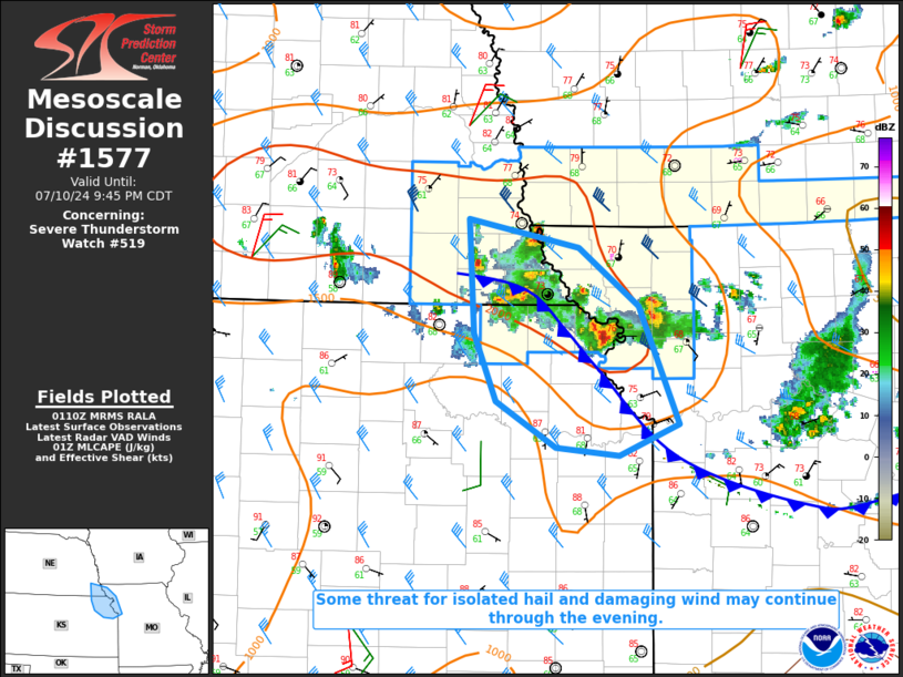
FOR ADDITIONAL INFORMATION SEE MESOSCALE DISCUSSION 1577
..DEAN..07/11/24
ATTN...WFO...DMX...OAX...DVN...TOP...EAX...LSX...
&&
STATUS REPORT FOR WS 519
SEVERE WEATHER THREAT CONTINUES FOR THE FOLLOWING AREAS
MOC003-021-049-063-075-087-147-110300-
MO
. MISSOURI COUNTIES INCLUDED ARE
ANDREW BUCHANAN CLINTON
DEKALB GENTRY HOLT
NODAWAY
$$
THE WATCH STATUS MESSAGE IS FOR GUIDANCE PURPOSES ONLY. PLEASE
REFER TO WATCH COUNTY NOTIFICATION STATEMENTS FOR OFFICIAL
INFORMATION ON COUNTIES...INDEPENDENT CITIES AND MARINE ZONES
CLEARED FROM SEVERE THUNDERSTORM AND TORNADO WATCHES.
$$
STATUS REPORT #4 ON WW 519
VALID 110145Z - 110240Z
SEVERE WEATHER THREAT CONTINUES RIGHT OF A LINE FROM 20 SW LNK TO
15 S SDA TO 40 NNE STJ TO 10 SSW CDJ TO 45 WNW COU.
FOR ADDITIONAL INFORMATION SEE MESOSCALE DISCUSSION 1577
..DEAN..07/11/24
ATTN...WFO...DMX...OAX...DVN...TOP...EAX...LSX...
&&
STATUS REPORT FOR WS 519
SEVERE WEATHER THREAT CONTINUES FOR THE FOLLOWING AREAS
KSC013-043-131-110240-
KS
. KANSAS COUNTIES INCLUDED ARE
BROWN DONIPHAN NEMAHA
$$
MOC003-005-021-049-063-075-087-147-110240-
MO
. MISSOURI COUNTIES INCLUDED ARE
ANDREW ATCHISON BUCHANAN
CLINTON DEKALB GENTRY
HOLT NODAWAY
$$
NEC097-127-133-147-110240-
NE
. NEBRASKA COUNTIES INCLUDED ARE
JOHNSON NEMAHA PAWNEE
RICHARDSON
$$
THE WATCH STATUS MESSAGE IS FOR GUIDANCE PURPOSES ONLY. PLEASE
REFER TO WATCH COUNTY NOTIFICATION STATEMENTS FOR OFFICIAL
INFORMATION ON COUNTIES...INDEPENDENT CITIES AND MARINE ZONES
CLEARED FROM SEVERE THUNDERSTORM AND TORNADO WATCHES.
$$
STATUS REPORT #3 ON WW 519
VALID 110005Z - 110140Z
SEVERE WEATHER THREAT CONTINUES RIGHT OF A LINE FROM 30 W LNK TO
10 SW SDA TO 40 WSW LWD TO 50 NW COU TO 30 NNW COU.
..LYONS..07/11/24
ATTN...WFO...DMX...OAX...DVN...TOP...EAX...LSX...
&&
STATUS REPORT FOR WS 519
SEVERE WEATHER THREAT CONTINUES FOR THE FOLLOWING AREAS
IAC071-110140-
IA
. IOWA COUNTIES INCLUDED ARE
FREMONT
$$
KSC013-043-131-110140-
KS
. KANSAS COUNTIES INCLUDED ARE
BROWN DONIPHAN NEMAHA
$$
MOC003-005-021-049-063-075-087-147-110140-
MO
. MISSOURI COUNTIES INCLUDED ARE
ANDREW ATCHISON BUCHANAN
CLINTON DEKALB GENTRY
HOLT NODAWAY
$$
NEC067-097-109-127-131-133-147-110140-
NE
. NEBRASKA COUNTIES INCLUDED ARE
GAGE JOHNSON LANCASTER
NEMAHA OTOE PAWNEE
RICHARDSON
$$
THE WATCH STATUS MESSAGE IS FOR GUIDANCE PURPOSES ONLY. PLEASE
REFER TO WATCH COUNTY NOTIFICATION STATEMENTS FOR OFFICIAL
INFORMATION ON COUNTIES...INDEPENDENT CITIES AND MARINE ZONES
CLEARED FROM SEVERE THUNDERSTORM AND TORNADO WATCHES.
$$
STATUS REPORT #2 ON WW 519
VALID 102315Z - 110040Z
SEVERE WEATHER THREAT CONTINUES RIGHT OF A LINE FROM 20 WNW LNK
TO 10 NE SDA TO 10 ESE LWD TO 25 WNW IRK TO 25 NE IRK TO 15 SW
BRL.
..LYONS..07/10/24
ATTN...WFO...DMX...OAX...DVN...TOP...EAX...LSX...
&&
STATUS REPORT FOR WS 519
SEVERE WEATHER THREAT CONTINUES FOR THE FOLLOWING AREAS
IAC071-145-173-110040-
IA
. IOWA COUNTIES INCLUDED ARE
FREMONT PAGE TAYLOR
$$
KSC013-043-131-110040-
KS
. KANSAS COUNTIES INCLUDED ARE
BROWN DONIPHAN NEMAHA
$$
MOC001-003-005-021-025-033-041-045-049-061-063-075-079-081-087-
103-111-115-117-121-127-129-137-147-175-177-205-211-227-
110040-
MO
. MISSOURI COUNTIES INCLUDED ARE
ADAIR ANDREW ATCHISON
BUCHANAN CALDWELL CARROLL
CHARITON CLARK CLINTON
DAVIESS DEKALB GENTRY
GRUNDY HARRISON HOLT
KNOX LEWIS LINN
LIVINGSTON MACON MARION
MERCER MONROE NODAWAY
RANDOLPH RAY SHELBY
SULLIVAN WORTH
$$
NEC067-097-109-127-131-133-147-110040-
NE
. NEBRASKA COUNTIES INCLUDED ARE
GAGE JOHNSON LANCASTER
NEMAHA OTOE PAWNEE
RICHARDSON
$$
THE WATCH STATUS MESSAGE IS FOR GUIDANCE PURPOSES ONLY. PLEASE
REFER TO WATCH COUNTY NOTIFICATION STATEMENTS FOR OFFICIAL
INFORMATION ON COUNTIES...INDEPENDENT CITIES AND MARINE ZONES
CLEARED FROM SEVERE THUNDERSTORM AND TORNADO WATCHES.
$$
STATUS REPORT #1 ON WW 519
VALID 102135Z - 102240Z
THE SEVERE WEATHER THREAT CONTINUES ACROSS THE ENTIRE WATCH AREA.
..LYONS..07/10/24
ATTN...WFO...DMX...OAX...DVN...TOP...EAX...LSX...
&&
STATUS REPORT FOR WS 519
SEVERE WEATHER THREAT CONTINUES FOR THE FOLLOWING AREAS
IAC003-007-039-051-053-071-129-137-145-159-173-175-177-185-
102240-
IA
. IOWA COUNTIES INCLUDED ARE
ADAMS APPANOOSE CLARKE
DAVIS DECATUR FREMONT
MILLS MONTGOMERY PAGE
RINGGOLD TAYLOR UNION
VAN BUREN WAYNE
$$
KSC013-043-131-102240-
KS
. KANSAS COUNTIES INCLUDED ARE
BROWN DONIPHAN NEMAHA
$$
MOC001-003-005-021-025-033-041-045-049-061-063-075-079-081-087-
103-111-115-117-121-127-129-137-147-171-175-177-197-199-205-211-
227-102240-
MO
. MISSOURI COUNTIES INCLUDED ARE
ADAIR ANDREW ATCHISON
BUCHANAN CALDWELL CARROLL
CHARITON CLARK CLINTON
DAVIESS DEKALB GENTRY
GRUNDY HARRISON HOLT
KNOX LEWIS LINN
LIVINGSTON MACON MARION
MERCER MONROE NODAWAY
PUTNAM RANDOLPH RAY
SCHUYLER SCOTLAND SHELBY
SULLIVAN WORTH
$$
NEC025-067-097-109-127-131-133-147-102240-
NE
. NEBRASKA COUNTIES INCLUDED ARE
CASS GAGE JOHNSON
LANCASTER NEMAHA OTOE
PAWNEE RICHARDSON
$$
THE WATCH STATUS MESSAGE IS FOR GUIDANCE PURPOSES ONLY. PLEASE
REFER TO WATCH COUNTY NOTIFICATION STATEMENTS FOR OFFICIAL
INFORMATION ON COUNTIES...INDEPENDENT CITIES AND MARINE ZONES
CLEARED FROM SEVERE THUNDERSTORM AND TORNADO WATCHES.
$$
Note:
Click for Complete Product Text.
Tornadoes
Probability of 2 or more tornadoes
|
Low (10%)
|
Probability of 1 or more strong (EF2-EF5) tornadoes
|
Low (5%)
|
Wind
Probability of 10 or more severe wind events
|
Mod (50%)
|
Probability of 1 or more wind events > 65 knots
|
Low (20%)
|
Hail
Probability of 10 or more severe hail events
|
Mod (40%)
|
Probability of 1 or more hailstones > 2 inches
|
Low (10%)
|
Combined Severe Hail/Wind
Probability of 6 or more combined severe hail/wind events
|
High (90%)
|
For each watch, probabilities for particular events inside the watch
(listed above in each table) are determined by the issuing forecaster.
The "Low" category contains probability values ranging from less than 2%
to 20% (EF2-EF5 tornadoes), less than 5% to 20% (all other probabilities),
"Moderate" from 30% to 60%, and "High" from 70% to greater than 95%.
High values are bolded and lighter in color to provide awareness of
an increased threat for a particular event.


 @NWSSPC