 Note:
The expiration time in the watch graphic is amended if the watch is
replaced, cancelled or extended.
Note:
Note:
The expiration time in the watch graphic is amended if the watch is
replaced, cancelled or extended.
Note: Click for
Watch Status Reports.
SEL8
URGENT - IMMEDIATE BROADCAST REQUESTED
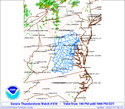
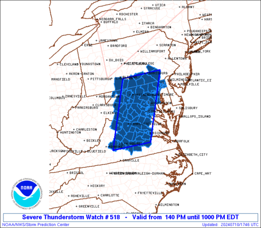
Severe Thunderstorm Watch Number 518
NWS Storm Prediction Center Norman OK
140 PM EDT Wed Jul 10 2024
The NWS Storm Prediction Center has issued a
* Severe Thunderstorm Watch for portions of
District Of Columbia
Maryland
Southern Pennsylvania
Virginia
Far Eastern West Virginia
Coastal Waters
* Effective this Wednesday afternoon and evening from 140 PM
until 1000 PM EDT.
* Primary threats include...
Scattered damaging wind gusts to 65 mph likely
A tornado or two possible
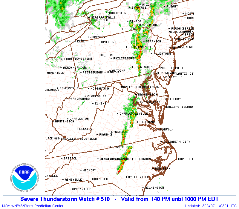
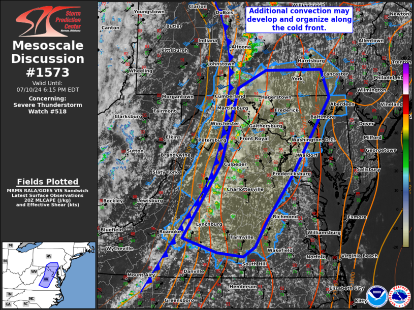
SUMMARY...Scattered storms will continue to develop and intensify
across the region, with the most sustained storms potentially
focused across southern Pennsylvania, interior Maryland, into
northern/central Virginia. Damaging winds will be the most common
severe concern.
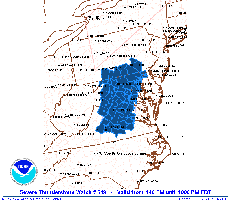
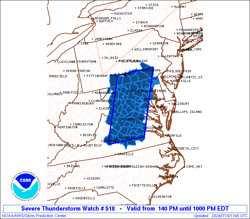
The severe thunderstorm watch area is approximately along and 60
statute miles east and west of a line from 50 miles northeast of
Hagerstown MD to 40 miles east southeast of Lynchburg VA. For a
complete depiction of the watch see the associated watch outline
update (WOUS64 KWNS WOU8).
PRECAUTIONARY/PREPAREDNESS ACTIONS...
REMEMBER...A Severe Thunderstorm Watch means conditions are
favorable for severe thunderstorms in and close to the watch area.
Persons in these areas should be on the lookout for threatening
weather conditions and listen for later statements and possible
warnings. Severe thunderstorms can and occasionally do produce
tornadoes.
&&
OTHER WATCH INFORMATION...CONTINUE...WW 517...
AVIATION...A few severe thunderstorms with hail surface and aloft to
1 inch. Extreme turbulence and surface wind gusts to 55 knots. A few
cumulonimbi with maximum tops to 550. Mean storm motion vector
24025.
...Guyer
   SEL8

   URGENT - IMMEDIATE BROADCAST REQUESTED
   Severe Thunderstorm Watch Number 518
   NWS Storm Prediction Center Norman OK
   140 PM EDT Wed Jul 10 2024

   The NWS Storm Prediction Center has issued a

   * Severe Thunderstorm Watch for portions of
     District Of Columbia
     Maryland
     Southern Pennsylvania
     Virginia
     Far Eastern West Virginia
     Coastal Waters

   * Effective this Wednesday afternoon and evening from 140 PM
     until 1000 PM EDT.

   * Primary threats include...
     Scattered damaging wind gusts to 65 mph likely
     A tornado or two possible

   SUMMARY...Scattered storms will continue to develop and intensify
   across the region, with the most sustained storms potentially
   focused across southern Pennsylvania, interior Maryland, into
   northern/central Virginia. Damaging winds will be the most common
   severe concern.

   The severe thunderstorm watch area is approximately along and 60
   statute miles east and west of a line from 50 miles northeast of
   Hagerstown MD to 40 miles east southeast of Lynchburg VA. For a
   complete depiction of the watch see the associated watch outline
   update (WOUS64 KWNS WOU8).

   PRECAUTIONARY/PREPAREDNESS ACTIONS...

   REMEMBER...A Severe Thunderstorm Watch means conditions are
   favorable for severe thunderstorms in and close to the watch area.
   Persons in these areas should be on the lookout for threatening
   weather conditions and listen for later statements and possible
   warnings. Severe thunderstorms can and occasionally do produce
   tornadoes.

   &&

   OTHER WATCH INFORMATION...CONTINUE...WW 517...

   AVIATION...A few severe thunderstorms with hail surface and aloft to
   1 inch. Extreme turbulence and surface wind gusts to 55 knots. A few
   cumulonimbi with maximum tops to 550. Mean storm motion vector
   24025.

   ...Guyer
 Note:
The Aviation Watch (SAW) product is an approximation to the watch area.
The actual watch is depicted by the shaded areas.
Note:
The Aviation Watch (SAW) product is an approximation to the watch area.
The actual watch is depicted by the shaded areas.
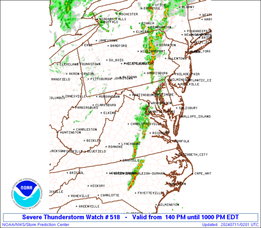
   SAW8
   WW 518 SEVERE TSTM DC MD PA VA WV CW 101740Z - 110200Z
   AXIS..60 STATUTE MILES EAST AND WEST OF LINE..
   50NE HGR/HAGERSTOWN MD/ - 40ESE LYH/LYNCHBURG VA/
   ..AVIATION COORDS.. 50NM E/W /2SW HAR - 35ESE LYH/
   HAIL SURFACE AND ALOFT..1 INCH. WIND GUSTS..55 KNOTS.
   MAX TOPS TO 550. MEAN STORM MOTION VECTOR 24025.

   LAT...LON 40207591 37097744 37097962 40207819

   THIS IS AN APPROXIMATION TO THE WATCH AREA.  FOR A
   COMPLETE DEPICTION OF THE WATCH SEE WOUS64 KWNS
   FOR WOU8.
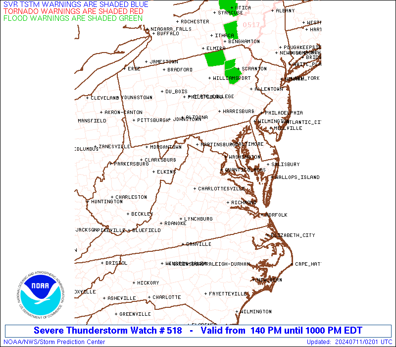
Watch 518 Status Report Messages:
STATUS REPORT #5 ON WW 518

VALID 110050Z - 110140Z

SEVERE WEATHER THREAT CONTINUES RIGHT OF A LINE FROM 10 E RIC TO
30 SE CHO TO 15 SE BWI TO 10 ENE CXY.

..LEITMAN..07/11/24

ATTN...WFO...LWX...CTP...AKQ...RNK...

&&

STATUS REPORT FOR WS 518

SEVERE WEATHER THREAT CONTINUES FOR THE FOLLOWING AREAS

MDC003-015-017-025-033-110140-

MD
.    MARYLAND COUNTIES INCLUDED ARE

ANNE ARUNDEL	     CECIL		 CHARLES
HARFORD 	     PRINCE GEORGES
$$


PAC071-075-110140-

PA
.    PENNSYLVANIA COUNTIES INCLUDED ARE

LANCASTER	     LEBANON
$$


VAC033-085-099-177-630-110140-

VA
.    VIRGINIA COUNTIES INCLUDED ARE

CAROLINE	     HANOVER		 KING GEORGE
SPOTSYLVANIA


VIRGINIA INDEPENDENT CITIES INCLUDED ARE

FREDERICKSBURG
$$


ANZ530-532-110140-

CW

.    ADJACENT COASTAL WATERS INCLUDED ARE

CHESAPEAKE BAY NORTH OF POOLES ISLAND MD

CHESAPEAKE BAY FROM SANDY POINT TO NORTH BEACH MD

$$
THE WATCH STATUS MESSAGE IS FOR GUIDANCE PURPOSES ONLY.  PLEASE
REFER TO WATCH COUNTY NOTIFICATION STATEMENTS FOR OFFICIAL
INFORMATION ON COUNTIES...INDEPENDENT CITIES AND MARINE ZONES
CLEARED FROM SEVERE THUNDERSTORM AND TORNADO WATCHES.
$$

STATUS REPORT #4 ON WW 518

VALID 110000Z - 110140Z

SEVERE WEATHER THREAT CONTINUES RIGHT OF A LINE FROM 20 SE LYH TO
25 NE CHO TO 5 ENE MRB TO 40 SSE UNV.

..LYONS..07/11/24

ATTN...WFO...LWX...CTP...AKQ...RNK...

&&

STATUS REPORT FOR WS 518

SEVERE WEATHER THREAT CONTINUES FOR THE FOLLOWING AREAS

DCC001-110140-

DC
.    DISTRICT OF COLUMBIA COUNTIES INCLUDED ARE

DISTRICT OF COLUMBIA
$$


MDC003-005-013-015-017-021-025-027-031-033-510-110140-

MD
.    MARYLAND COUNTIES INCLUDED ARE

ANNE ARUNDEL	     BALTIMORE		 CARROLL
CECIL		     CHARLES		 FREDERICK
HARFORD 	     HOWARD		 MONTGOMERY
PRINCE GEORGES


MARYLAND INDEPENDENT CITIES INCLUDED ARE

BALTIMORE CITY
$$


PAC001-041-071-075-133-110140-

PA
.    PENNSYLVANIA COUNTIES INCLUDED ARE

ADAMS		     CUMBERLAND 	 LANCASTER
LEBANON 	     YORK
$$


VAC007-011-013-029-033-037-041-047-049-053-059-061-065-075-085-
087-099-107-109-111-135-137-145-147-153-177-179-510-570-600-610-
630-683-685-730-760-110140-

VA
.    VIRGINIA COUNTIES INCLUDED ARE

AMELIA		     APPOMATTOX 	 ARLINGTON
BUCKINGHAM	     CAROLINE		 CHARLOTTE
CHESTERFIELD	     CULPEPER		 CUMBERLAND
DINWIDDIE	     FAIRFAX		 FAUQUIER
FLUVANNA	     GOOCHLAND		 HANOVER
HENRICO 	     KING GEORGE	 LOUDOUN
LOUISA		     LUNENBURG		 NOTTOWAY
ORANGE		     POWHATAN		 PRINCE EDWARD
PRINCE WILLIAM	     SPOTSYLVANIA	 STAFFORD


VIRGINIA INDEPENDENT CITIES INCLUDED ARE

ALEXANDRIA	     COLONIAL HEIGHTS	 FAIRFAX
FALLS CHURCH	     FREDERICKSBURG	 MANASSAS
MANASSAS PARK	     PETERSBURG 	 RICHMOND
$$


WVC037-110140-

WV
.    WEST VIRGINIA COUNTIES INCLUDED ARE

JEFFERSON
$$


ANZ530-531-532-535-536-538-110140-

CW

.    ADJACENT COASTAL WATERS INCLUDED ARE

CHESAPEAKE BAY NORTH OF POOLES ISLAND MD

CHESAPEAKE BAY FROM POOLES ISLAND TO SANDY POINT MD

CHESAPEAKE BAY FROM SANDY POINT TO NORTH BEACH MD

TIDAL POTOMAC FROM KEY BRIDGE TO INDIAN HEAD MD

TIDAL POTOMAC FROM INDIAN HEAD TO COBB ISLAND MD

PATAPSCO RIVER INCLUDING BALTIMORE HARBOR

$$
THE WATCH STATUS MESSAGE IS FOR GUIDANCE PURPOSES ONLY.  PLEASE
REFER TO WATCH COUNTY NOTIFICATION STATEMENTS FOR OFFICIAL
INFORMATION ON COUNTIES...INDEPENDENT CITIES AND MARINE ZONES
CLEARED FROM SEVERE THUNDERSTORM AND TORNADO WATCHES.
$$

STATUS REPORT #3 ON WW 518

VALID 102135Z - 102240Z

SEVERE WEATHER THREAT CONTINUES RIGHT OF A LINE FROM 15 SSE LYH
TO 10 W CHO TO 20 W HGR TO 30 NNW UNV.

..LYONS..07/10/24

ATTN...WFO...LWX...CTP...AKQ...RNK...

&&

STATUS REPORT FOR WS 518

SEVERE WEATHER THREAT CONTINUES FOR THE FOLLOWING AREAS

DCC001-102240-

DC
.    DISTRICT OF COLUMBIA COUNTIES INCLUDED ARE

DISTRICT OF COLUMBIA
$$


MDC003-005-013-015-017-021-025-027-031-033-043-510-102240-

MD
.    MARYLAND COUNTIES INCLUDED ARE

ANNE ARUNDEL	     BALTIMORE		 CARROLL
CECIL		     CHARLES		 FREDERICK
HARFORD 	     HOWARD		 MONTGOMERY
PRINCE GEORGES	     WASHINGTON


MARYLAND INDEPENDENT CITIES INCLUDED ARE

BALTIMORE CITY
$$


PAC001-041-055-071-075-133-102240-

PA
.    PENNSYLVANIA COUNTIES INCLUDED ARE

ADAMS		     CUMBERLAND 	 FRANKLIN
LANCASTER	     LEBANON		 YORK
$$


VAC003-007-011-013-029-031-033-037-041-043-047-049-053-059-061-
065-075-079-085-087-099-107-109-111-113-135-137-139-145-147-153-
157-177-179-187-510-540-570-600-610-630-683-685-730-760-
102240-

VA
.    VIRGINIA COUNTIES INCLUDED ARE

ALBEMARLE	     AMELIA		 APPOMATTOX
ARLINGTON	     BUCKINGHAM 	 CAMPBELL
CAROLINE	     CHARLOTTE		 CHESTERFIELD
CLARKE		     CULPEPER		 CUMBERLAND
DINWIDDIE	     FAIRFAX		 FAUQUIER
FLUVANNA	     GOOCHLAND		 GREENE
HANOVER 	     HENRICO		 KING GEORGE
LOUDOUN 	     LOUISA		 LUNENBURG
MADISON 	     NOTTOWAY		 ORANGE
PAGE		     POWHATAN		 PRINCE EDWARD
PRINCE WILLIAM	     RAPPAHANNOCK	 SPOTSYLVANIA
STAFFORD	     WARREN


VIRGINIA INDEPENDENT CITIES INCLUDED ARE

ALEXANDRIA	     CHARLOTTESVILLE	 COLONIAL HEIGHTS
FAIRFAX 	     FALLS CHURCH	 FREDERICKSBURG
MANASSAS	     MANASSAS PARK	 PETERSBURG
RICHMOND
$$


WVC003-037-102240-

WV
.    WEST VIRGINIA COUNTIES INCLUDED ARE

BERKELEY	     JEFFERSON
$$


ANZ530-531-532-535-536-538-102240-

CW

.    ADJACENT COASTAL WATERS INCLUDED ARE

CHESAPEAKE BAY NORTH OF POOLES ISLAND MD

CHESAPEAKE BAY FROM POOLES ISLAND TO SANDY POINT MD

CHESAPEAKE BAY FROM SANDY POINT TO NORTH BEACH MD

TIDAL POTOMAC FROM KEY BRIDGE TO INDIAN HEAD MD

TIDAL POTOMAC FROM INDIAN HEAD TO COBB ISLAND MD

PATAPSCO RIVER INCLUDING BALTIMORE HARBOR

$$
THE WATCH STATUS MESSAGE IS FOR GUIDANCE PURPOSES ONLY.  PLEASE
REFER TO WATCH COUNTY NOTIFICATION STATEMENTS FOR OFFICIAL
INFORMATION ON COUNTIES...INDEPENDENT CITIES AND MARINE ZONES
CLEARED FROM SEVERE THUNDERSTORM AND TORNADO WATCHES.
$$

STATUS REPORT #2 ON WW 518

VALID 102025Z - 102140Z

SEVERE WEATHER THREAT CONTINUES RIGHT OF A LINE FROM 20 WSW LYH
TO 5 S SHD TO 30 SW MRB TO 5 SE AOO.

FOR ADDITIONAL INFORMATION SEE MESOSCALE DISCUSSION 1573

..LYONS..07/10/24

ATTN...WFO...LWX...CTP...AKQ...RNK...

&&

STATUS REPORT FOR WS 518

SEVERE WEATHER THREAT CONTINUES FOR THE FOLLOWING AREAS

DCC001-102140-

DC
.    DISTRICT OF COLUMBIA COUNTIES INCLUDED ARE

DISTRICT OF COLUMBIA
$$


MDC003-005-013-015-017-021-025-027-031-033-043-510-102140-

MD
.    MARYLAND COUNTIES INCLUDED ARE

ANNE ARUNDEL	     BALTIMORE		 CARROLL
CECIL		     CHARLES		 FREDERICK
HARFORD 	     HOWARD		 MONTGOMERY
PRINCE GEORGES	     WASHINGTON


MARYLAND INDEPENDENT CITIES INCLUDED ARE

BALTIMORE CITY
$$


PAC001-041-055-057-071-075-133-102140-

PA
.    PENNSYLVANIA COUNTIES INCLUDED ARE

ADAMS		     CUMBERLAND 	 FRANKLIN
FULTON		     LANCASTER		 LEBANON
YORK
$$


VAC003-007-009-011-013-019-029-031-033-037-041-043-047-049-053-
059-061-065-069-075-079-085-087-099-107-109-111-113-125-135-137-
139-145-147-153-157-177-179-187-510-540-570-600-610-630-680-683-
685-730-760-840-102140-

VA
.    VIRGINIA COUNTIES INCLUDED ARE

ALBEMARLE	     AMELIA		 AMHERST
APPOMATTOX	     ARLINGTON		 BEDFORD
BUCKINGHAM	     CAMPBELL		 CAROLINE
CHARLOTTE	     CHESTERFIELD	 CLARKE
CULPEPER	     CUMBERLAND 	 DINWIDDIE
FAIRFAX 	     FAUQUIER		 FLUVANNA
FREDERICK	     GOOCHLAND		 GREENE
HANOVER 	     HENRICO		 KING GEORGE
LOUDOUN 	     LOUISA		 LUNENBURG
MADISON 	     NELSON		 NOTTOWAY
ORANGE		     PAGE		 POWHATAN
PRINCE EDWARD	     PRINCE WILLIAM	 RAPPAHANNOCK
SPOTSYLVANIA	     STAFFORD		 WARREN


VIRGINIA INDEPENDENT CITIES INCLUDED ARE

ALEXANDRIA	     CHARLOTTESVILLE	 COLONIAL HEIGHTS
FAIRFAX 	     FALLS CHURCH	 FREDERICKSBURG
LYNCHBURG	     MANASSAS		 MANASSAS PARK
PETERSBURG	     RICHMOND		 WINCHESTER
$$


WVC003-037-065-102140-

WV
.    WEST VIRGINIA COUNTIES INCLUDED ARE

BERKELEY	     JEFFERSON		 MORGAN
$$


ANZ530-531-532-535-536-538-102140-

CW

.    ADJACENT COASTAL WATERS INCLUDED ARE

CHESAPEAKE BAY NORTH OF POOLES ISLAND MD

CHESAPEAKE BAY FROM POOLES ISLAND TO SANDY POINT MD

CHESAPEAKE BAY FROM SANDY POINT TO NORTH BEACH MD

TIDAL POTOMAC FROM KEY BRIDGE TO INDIAN HEAD MD

TIDAL POTOMAC FROM INDIAN HEAD TO COBB ISLAND MD

PATAPSCO RIVER INCLUDING BALTIMORE HARBOR

$$
THE WATCH STATUS MESSAGE IS FOR GUIDANCE PURPOSES ONLY.  PLEASE
REFER TO WATCH COUNTY NOTIFICATION STATEMENTS FOR OFFICIAL
INFORMATION ON COUNTIES...INDEPENDENT CITIES AND MARINE ZONES
CLEARED FROM SEVERE THUNDERSTORM AND TORNADO WATCHES.
$$

STATUS REPORT #1 ON WW 518

VALID 101900Z - 102040Z

THE SEVERE WEATHER THREAT CONTINUES ACROSS THE ENTIRE WATCH AREA.

..LYONS..07/10/24

ATTN...WFO...LWX...CTP...AKQ...RNK...

&&

STATUS REPORT FOR WS 518

SEVERE WEATHER THREAT CONTINUES FOR THE FOLLOWING AREAS

DCC001-102040-

DC
.    DISTRICT OF COLUMBIA COUNTIES INCLUDED ARE

DISTRICT OF COLUMBIA
$$


MDC001-003-005-013-015-017-021-025-027-031-033-043-510-102040-

MD
.    MARYLAND COUNTIES INCLUDED ARE

ALLEGANY	     ANNE ARUNDEL	 BALTIMORE
CARROLL 	     CECIL		 CHARLES
FREDERICK	     HARFORD		 HOWARD
MONTGOMERY	     PRINCE GEORGES	 WASHINGTON


MARYLAND INDEPENDENT CITIES INCLUDED ARE

BALTIMORE CITY
$$


PAC001-009-041-055-057-071-075-133-102040-

PA
.    PENNSYLVANIA COUNTIES INCLUDED ARE

ADAMS		     BEDFORD		 CUMBERLAND
FRANKLIN	     FULTON		 LANCASTER
LEBANON 	     YORK
$$


VAC003-007-009-011-013-015-019-029-031-033-037-041-043-047-049-
053-059-061-065-069-075-079-085-087-099-107-109-111-113-125-135-
137-139-145-147-153-157-165-171-177-179-187-510-540-570-600-610-
630-660-680-683-685-730-760-790-820-840-102040-

VA
.    VIRGINIA COUNTIES INCLUDED ARE

ALBEMARLE	     AMELIA		 AMHERST
APPOMATTOX	     ARLINGTON		 AUGUSTA
BEDFORD 	     BUCKINGHAM 	 CAMPBELL
CAROLINE	     CHARLOTTE		 CHESTERFIELD
CLARKE		     CULPEPER		 CUMBERLAND
DINWIDDIE	     FAIRFAX		 FAUQUIER
FLUVANNA	     FREDERICK		 GOOCHLAND
GREENE		     HANOVER		 HENRICO
KING GEORGE	     LOUDOUN		 LOUISA
LUNENBURG	     MADISON		 NELSON
NOTTOWAY	     ORANGE		 PAGE
POWHATAN	     PRINCE EDWARD	 PRINCE WILLIAM
RAPPAHANNOCK	     ROCKINGHAM 	 SHENANDOAH
SPOTSYLVANIA	     STAFFORD		 WARREN


VIRGINIA INDEPENDENT CITIES INCLUDED ARE

ALEXANDRIA	     CHARLOTTESVILLE	 COLONIAL HEIGHTS
FAIRFAX 	     FALLS CHURCH	 FREDERICKSBURG
HARRISONBURG	     LYNCHBURG		 MANASSAS
MANASSAS PARK	     PETERSBURG 	 RICHMOND
STAUNTON	     WAYNESBORO 	 WINCHESTER
$$


WVC003-027-031-037-065-102040-

WV
.    WEST VIRGINIA COUNTIES INCLUDED ARE

BERKELEY	     HAMPSHIRE		 HARDY
JEFFERSON	     MORGAN
$$


ANZ530-531-532-535-536-538-102040-

CW

.    ADJACENT COASTAL WATERS INCLUDED ARE

CHESAPEAKE BAY NORTH OF POOLES ISLAND MD

CHESAPEAKE BAY FROM POOLES ISLAND TO SANDY POINT MD

CHESAPEAKE BAY FROM SANDY POINT TO NORTH BEACH MD

TIDAL POTOMAC FROM KEY BRIDGE TO INDIAN HEAD MD

TIDAL POTOMAC FROM INDIAN HEAD TO COBB ISLAND MD

PATAPSCO RIVER INCLUDING BALTIMORE HARBOR

$$
THE WATCH STATUS MESSAGE IS FOR GUIDANCE PURPOSES ONLY.  PLEASE
REFER TO WATCH COUNTY NOTIFICATION STATEMENTS FOR OFFICIAL
INFORMATION ON COUNTIES...INDEPENDENT CITIES AND MARINE ZONES
CLEARED FROM SEVERE THUNDERSTORM AND TORNADO WATCHES.
$$
Note:
Click for Complete Product Text.
Tornadoes
Probability of 2 or more tornadoes
|
Low (20%)
|
Probability of 1 or more strong (EF2-EF5) tornadoes
|
Low (5%)
|
Wind
Probability of 10 or more severe wind events
|
High (70%)
|
Probability of 1 or more wind events > 65 knots
|
Low (10%)
|
Hail
Probability of 10 or more severe hail events
|
Low (<5%)
|
Probability of 1 or more hailstones > 2 inches
|
Low (<5%)
|
Combined Severe Hail/Wind
Probability of 6 or more combined severe hail/wind events
|
High (80%)
|
For each watch, probabilities for particular events inside the watch
(listed above in each table) are determined by the issuing forecaster.
The "Low" category contains probability values ranging from less than 2%
to 20% (EF2-EF5 tornadoes), less than 5% to 20% (all other probabilities),
"Moderate" from 30% to 60%, and "High" from 70% to greater than 95%.
High values are bolded and lighter in color to provide awareness of
an increased threat for a particular event.


 @NWSSPC