 Note:
The expiration time in the watch graphic is amended if the watch is
replaced, cancelled or extended.
Note:
Note:
The expiration time in the watch graphic is amended if the watch is
replaced, cancelled or extended.
Note: Click for
Watch Status Reports.
SEL7
URGENT - IMMEDIATE BROADCAST REQUESTED
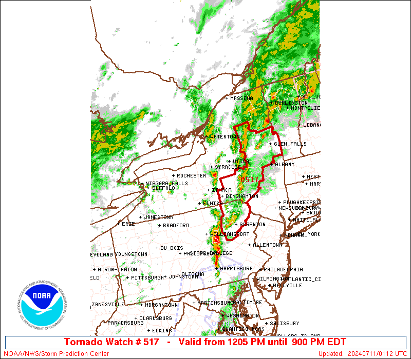
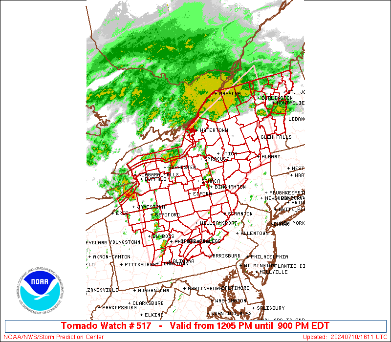
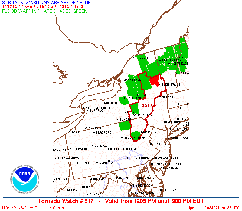
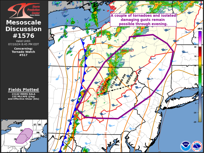
Tornado Watch Number 517
NWS Storm Prediction Center Norman OK
1205 PM EDT Wed Jul 10 2024
The NWS Storm Prediction Center has issued a
* Tornado Watch for portions of
Upstate New York
Northern and Central Pennsylvania
Vermont
Lake Erie
Lake Ontario
* Effective this Wednesday afternoon and evening from 1205 PM
until 900 PM EDT.
* Primary threats include...
A few tornadoes likely
Scattered damaging wind gusts to 70 mph possible
SUMMARY...A moist air mass along and south of a warm front, and
strong atmospheric winds associated with the remnants of Beryl, will
influence storms capable of tornadoes and wind damage this afternoon
through early/mid-evening.
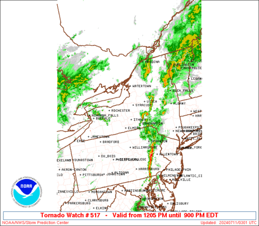
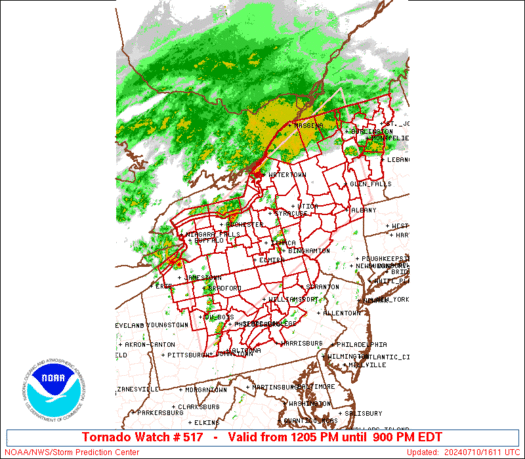
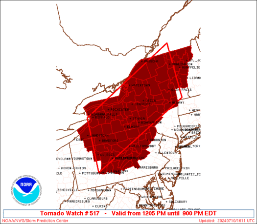
The tornado watch area is approximately along and 90 statute miles
north and south of a line from 25 miles west southwest of Bradford
PA to 25 miles south southeast of Burlington VT. For a complete
depiction of the watch see the associated watch outline update
(WOUS64 KWNS WOU7).
PRECAUTIONARY/PREPAREDNESS ACTIONS...
REMEMBER...A Tornado Watch means conditions are favorable for
tornadoes and severe thunderstorms in and close to the watch
area. Persons in these areas should be on the lookout for
threatening weather conditions and listen for later statements
and possible warnings.
&&
AVIATION...Tornadoes and a few severe thunderstorms with hail
surface and aloft to 0.5 inches. Extreme turbulence and surface wind
gusts to 60 knots. A few cumulonimbi with maximum tops to 500. Mean
storm motion vector 24025.
...Guyer
   SEL7

   URGENT - IMMEDIATE BROADCAST REQUESTED
   Tornado Watch Number 517
   NWS Storm Prediction Center Norman OK
   1205 PM EDT Wed Jul 10 2024

   The NWS Storm Prediction Center has issued a

   * Tornado Watch for portions of
     Upstate New York
     Northern and Central Pennsylvania
     Vermont
     Lake Erie
     Lake Ontario

   * Effective this Wednesday afternoon and evening from 1205 PM
     until 900 PM EDT.

   * Primary threats include...
     A few tornadoes likely
     Scattered damaging wind gusts to 70 mph possible

   SUMMARY...A moist air mass along and south of a warm front, and
   strong atmospheric winds associated with the remnants of Beryl, will
   influence storms capable of tornadoes and wind damage this afternoon
   through early/mid-evening.

   The tornado watch area is approximately along and 90 statute miles
   north and south of a line from 25 miles west southwest of Bradford
   PA to 25 miles south southeast of Burlington VT. For a complete
   depiction of the watch see the associated watch outline update
   (WOUS64 KWNS WOU7).

   PRECAUTIONARY/PREPAREDNESS ACTIONS...

   REMEMBER...A Tornado Watch means conditions are favorable for
   tornadoes and severe thunderstorms in and close to the watch
   area. Persons in these areas should be on the lookout for
   threatening weather conditions and listen for later statements
   and possible warnings.

   &&

   AVIATION...Tornadoes and a few severe thunderstorms with hail
   surface and aloft to 0.5 inches. Extreme turbulence and surface wind
   gusts to 60 knots. A few cumulonimbi with maximum tops to 500. Mean
   storm motion vector 24025.

   ...Guyer
 Note:
The Aviation Watch (SAW) product is an approximation to the watch area.
The actual watch is depicted by the shaded areas.
Note:
The Aviation Watch (SAW) product is an approximation to the watch area.
The actual watch is depicted by the shaded areas.
   SAW7
   WW 517 TORNADO NY PA VT LE LO 101605Z - 110100Z
   AXIS..90 STATUTE MILES NORTH AND SOUTH OF LINE..
   25WSW BFD/BRADFORD PA/ - 25SSE BTV/BURLINGTON VT/
   ..AVIATION COORDS.. 80NM N/S /32S JHW - 17WSW MPV/
   HAIL SURFACE AND ALOFT..0.5 INCH. WIND GUSTS..60 KNOTS.
   MAX TOPS TO 500. MEAN STORM MOTION VECTOR 24025.

   LAT...LON 42967908 45447296 42837296 40367908

   THIS IS AN APPROXIMATION TO THE WATCH AREA.  FOR A
   COMPLETE DEPICTION OF THE WATCH SEE WOUS64 KWNS
   FOR WOU7.
Watch 517 Status Report Messages:
STATUS REPORT #4 ON WW 517

VALID 102310Z - 110040Z

SEVERE WEATHER THREAT CONTINUES RIGHT OF A LINE FROM 25 ESE AOO
TO 25 WNW IPT TO 15 SW ITH TO 35 ENE ART TO 25 WNW BTV TO 25 ESE
EFK TO 35 NNE BML.

..LYONS..07/10/24

ATTN...WFO...ALY...BUF...BGM...BTV...CTP...PBZ...

&&

STATUS REPORT FOR WT 517

SEVERE WEATHER THREAT CONTINUES FOR THE FOLLOWING AREAS

NYC001-007-017-023-025-031-035-041-043-049-053-057-065-067-077-
083-091-093-095-107-113-115-110040-

NY
.    NEW YORK COUNTIES INCLUDED ARE

ALBANY		     BROOME		 CHENANGO
CORTLAND	     DELAWARE		 ESSEX
FULTON		     HAMILTON		 HERKIMER
LEWIS		     MADISON		 MONTGOMERY
ONEIDA		     ONONDAGA		 OTSEGO
RENSSELAER	     SARATOGA		 SCHENECTADY
SCHOHARIE	     TIOGA		 WARREN
WASHINGTON
$$


PAC015-037-043-067-069-079-081-087-093-097-099-107-109-113-115-
117-119-127-131-110040-

PA
.    PENNSYLVANIA COUNTIES INCLUDED ARE

BRADFORD	     COLUMBIA		 DAUPHIN
JUNIATA 	     LACKAWANNA 	 LUZERNE
LYCOMING	     MIFFLIN		 MONTOUR
NORTHUMBERLAND	     PERRY		 SCHUYLKILL
SNYDER		     SULLIVAN		 SUSQUEHANNA
TIOGA		     UNION		 WAYNE
WYOMING
$$


VTC001-005-007-009-015-017-021-023-027-110040-

VT
.    VERMONT COUNTIES INCLUDED ARE

ADDISON 	     CALEDONIA		 CHITTENDEN
ESSEX		     LAMOILLE		 ORANGE
RUTLAND 	     WASHINGTON 	 WINDSOR
$$


LOZ030-110040-

CW

.    ADJACENT COASTAL WATERS INCLUDED ARE

LOWER NIAGARA RIVER

$$
THE WATCH STATUS MESSAGE IS FOR GUIDANCE PURPOSES ONLY.  PLEASE
REFER TO WATCH COUNTY NOTIFICATION STATEMENTS FOR OFFICIAL
INFORMATION ON COUNTIES...INDEPENDENT CITIES AND MARINE ZONES
CLEARED FROM SEVERE THUNDERSTORM AND TORNADO WATCHES.
$$

STATUS REPORT #3 ON WW 517

VALID 102130Z - 102240Z

SEVERE WEATHER THREAT CONTINUES RIGHT OF A LINE FROM 15 SE AOO TO
40 S ROC TO 35 W ART.

..LYONS..07/10/24

ATTN...WFO...ALY...BUF...BGM...BTV...CTP...PBZ...

&&

STATUS REPORT FOR WT 517

SEVERE WEATHER THREAT CONTINUES FOR THE FOLLOWING AREAS

NYC001-007-011-015-017-019-023-025-031-033-035-041-043-045-049-
053-057-065-067-075-077-083-089-091-093-095-097-099-101-107-109-
113-115-123-102240-

NY
.    NEW YORK COUNTIES INCLUDED ARE

ALBANY		     BROOME		 CAYUGA
CHEMUNG 	     CHENANGO		 CLINTON
CORTLAND	     DELAWARE		 ESSEX
FRANKLIN	     FULTON		 HAMILTON
HERKIMER	     JEFFERSON		 LEWIS
MADISON 	     MONTGOMERY 	 ONEIDA
ONONDAGA	     OSWEGO		 OTSEGO
RENSSELAER	     ST. LAWRENCE	 SARATOGA
SCHENECTADY	     SCHOHARIE		 SCHUYLER
SENECA		     STEUBEN		 TIOGA
TOMPKINS	     WARREN		 WASHINGTON
YATES
$$


PAC015-027-035-037-043-061-067-069-079-081-087-093-097-099-107-
109-113-115-117-119-127-131-102240-

PA
.    PENNSYLVANIA COUNTIES INCLUDED ARE

BRADFORD	     CENTRE		 CLINTON
COLUMBIA	     DAUPHIN		 HUNTINGDON
JUNIATA 	     LACKAWANNA 	 LUZERNE
LYCOMING	     MIFFLIN		 MONTOUR
NORTHUMBERLAND	     PERRY		 SCHUYLKILL
SNYDER		     SULLIVAN		 SUSQUEHANNA
TIOGA		     UNION		 WAYNE
WYOMING
$$


VTC001-005-007-009-011-013-015-017-019-021-023-027-102240-

VT
.    VERMONT COUNTIES INCLUDED ARE

ADDISON 	     CALEDONIA		 CHITTENDEN
ESSEX		     FRANKLIN		 GRAND ISLE
LAMOILLE	     ORANGE		 ORLEANS
RUTLAND 	     WASHINGTON 	 WINDSOR
$$


LOZ030-044-045-064-065-SLZ022-024-102240-

CW

.    ADJACENT COASTAL WATERS INCLUDED ARE

LOWER NIAGARA RIVER

SODUS BAY TO MEXICO BAY NY

MEXICO BAY NY TO THE ST. LAWRENCE RIVER

SODUS BAY TO MEXICO BAY NY BEYOND 5NM OFF SHORELINE TO
US-CANADIAN BORDER

MEXICO BAY NY TO THE ST. LAWRENCE RIVER BEYOND 5NM OFF SHORELINE
TO US-CANADIAN BORDER

ST. LAWRENCE RIVER ABOVE OGDENSBURG NY

ST. LAWRENCE RIVER FROM OGDENSBURG TO ST. REGIS NY

$$
THE WATCH STATUS MESSAGE IS FOR GUIDANCE PURPOSES ONLY.  PLEASE
REFER TO WATCH COUNTY NOTIFICATION STATEMENTS FOR OFFICIAL
INFORMATION ON COUNTIES...INDEPENDENT CITIES AND MARINE ZONES
CLEARED FROM SEVERE THUNDERSTORM AND TORNADO WATCHES.
$$

STATUS REPORT #2 ON WW 517

VALID 102020Z - 102140Z

SEVERE WEATHER THREAT CONTINUES RIGHT OF A LINE FROM 5 WNW AOO TO
30 NNW UNV TO 25 SSE BUF TO 40 NNW BUF.

..LYONS..07/10/24

ATTN...WFO...ALY...BUF...BGM...BTV...CTP...PBZ...

&&

STATUS REPORT FOR WT 517

SEVERE WEATHER THREAT CONTINUES FOR THE FOLLOWING AREAS

NYC001-003-007-011-015-017-019-023-025-031-033-035-037-041-043-
045-049-051-053-055-057-063-065-067-069-073-075-077-083-089-091-
093-095-097-099-101-107-109-113-115-117-121-123-102140-

NY
.    NEW YORK COUNTIES INCLUDED ARE

ALBANY		     ALLEGANY		 BROOME
CAYUGA		     CHEMUNG		 CHENANGO
CLINTON 	     CORTLAND		 DELAWARE
ESSEX		     FRANKLIN		 FULTON
GENESEE 	     HAMILTON		 HERKIMER
JEFFERSON	     LEWIS		 LIVINGSTON
MADISON 	     MONROE		 MONTGOMERY
NIAGARA 	     ONEIDA		 ONONDAGA
ONTARIO 	     ORLEANS		 OSWEGO
OTSEGO		     RENSSELAER 	 ST. LAWRENCE
SARATOGA	     SCHENECTADY	 SCHOHARIE
SCHUYLER	     SENECA		 STEUBEN
TIOGA		     TOMPKINS		 WARREN
WASHINGTON	     WAYNE		 WYOMING
YATES
$$


PAC013-015-027-035-037-043-061-067-069-079-081-087-093-097-099-
105-107-109-113-115-117-119-127-131-102140-

PA
.    PENNSYLVANIA COUNTIES INCLUDED ARE

BLAIR		     BRADFORD		 CENTRE
CLINTON 	     COLUMBIA		 DAUPHIN
HUNTINGDON	     JUNIATA		 LACKAWANNA
LUZERNE 	     LYCOMING		 MIFFLIN
MONTOUR 	     NORTHUMBERLAND	 PERRY
POTTER		     SCHUYLKILL 	 SNYDER
SULLIVAN	     SUSQUEHANNA	 TIOGA
UNION		     WAYNE		 WYOMING
$$


VTC001-005-007-009-011-013-015-017-019-021-023-027-102140-

VT
.    VERMONT COUNTIES INCLUDED ARE

ADDISON 	     CALEDONIA		 CHITTENDEN
ESSEX		     FRANKLIN		 GRAND ISLE
LAMOILLE	     ORANGE		 ORLEANS
RUTLAND 	     WASHINGTON 	 WINDSOR
$$


LOZ030-042-043-044-045-062-063-064-065-SLZ022-024-102140-

CW

.    ADJACENT COASTAL WATERS INCLUDED ARE

LOWER NIAGARA RIVER

NIAGARA RIVER TO HAMLIN BEACH NY

HAMLIN BEACH TO SODUS BAY NY

SODUS BAY TO MEXICO BAY NY

MEXICO BAY NY TO THE ST. LAWRENCE RIVER

NIAGARA RIVER TO HAMLIN BEACH NY BEYOND 5NM OFF SHORELINE TO
US-CANADIAN BORDER

HAMLIN BEACH TO SODUS BAY NY BEYOND 5NM OFF SHORELINE TO
US-CANADIAN BORDER

SODUS BAY TO MEXICO BAY NY BEYOND 5NM OFF SHORELINE TO
US-CANADIAN BORDER

MEXICO BAY NY TO THE ST. LAWRENCE RIVER BEYOND 5NM OFF SHORELINE
TO US-CANADIAN BORDER

ST. LAWRENCE RIVER ABOVE OGDENSBURG NY

ST. LAWRENCE RIVER FROM OGDENSBURG TO ST. REGIS NY

$$
THE WATCH STATUS MESSAGE IS FOR GUIDANCE PURPOSES ONLY.  PLEASE
REFER TO WATCH COUNTY NOTIFICATION STATEMENTS FOR OFFICIAL
INFORMATION ON COUNTIES...INDEPENDENT CITIES AND MARINE ZONES
CLEARED FROM SEVERE THUNDERSTORM AND TORNADO WATCHES.
$$

STATUS REPORT #1 ON WW 517

VALID 101900Z - 102040Z

SEVERE WEATHER THREAT CONTINUES RIGHT OF A LINE FROM 20 W AOO TO
30 ESE DUJ TO 30 ENE DUJ TO 20 SSE BFD TO 10 SSW BFD TO 20 W BFD
TO 25 NNE FKL.

..LYONS..07/10/24

ATTN...WFO...ALY...BUF...BGM...BTV...CTP...PBZ...

&&

STATUS REPORT FOR WT 517

SEVERE WEATHER THREAT CONTINUES FOR THE FOLLOWING AREAS

NYC001-003-007-009-011-013-015-017-019-023-025-029-031-033-035-
037-041-043-045-049-051-053-055-057-063-065-067-069-073-075-077-
083-089-091-093-095-097-099-101-107-109-113-115-117-121-123-
102040-

NY
.    NEW YORK COUNTIES INCLUDED ARE

ALBANY		     ALLEGANY		 BROOME
CATTARAUGUS	     CAYUGA		 CHAUTAUQUA
CHEMUNG 	     CHENANGO		 CLINTON
CORTLAND	     DELAWARE		 ERIE
ESSEX		     FRANKLIN		 FULTON
GENESEE 	     HAMILTON		 HERKIMER
JEFFERSON	     LEWIS		 LIVINGSTON
MADISON 	     MONROE		 MONTGOMERY
NIAGARA 	     ONEIDA		 ONONDAGA
ONTARIO 	     ORLEANS		 OSWEGO
OTSEGO		     RENSSELAER 	 ST. LAWRENCE
SARATOGA	     SCHENECTADY	 SCHOHARIE
SCHUYLER	     SENECA		 STEUBEN
TIOGA		     TOMPKINS		 WARREN
WASHINGTON	     WAYNE		 WYOMING
YATES
$$


PAC013-015-023-027-035-037-043-061-067-069-079-081-083-087-093-
097-099-105-107-109-113-115-117-119-123-127-131-102040-

PA
.    PENNSYLVANIA COUNTIES INCLUDED ARE

BLAIR		     BRADFORD		 CAMERON
CENTRE		     CLINTON		 COLUMBIA
DAUPHIN 	     HUNTINGDON 	 JUNIATA
LACKAWANNA	     LUZERNE		 LYCOMING
MCKEAN		     MIFFLIN		 MONTOUR
NORTHUMBERLAND	     PERRY		 POTTER
SCHUYLKILL	     SNYDER		 SULLIVAN
SUSQUEHANNA	     TIOGA		 UNION
WARREN		     WAYNE		 WYOMING
$$


VTC001-005-007-009-011-013-015-017-019-021-023-027-102040-

VT
.    VERMONT COUNTIES INCLUDED ARE

ADDISON 	     CALEDONIA		 CHITTENDEN
ESSEX		     FRANKLIN		 GRAND ISLE
LAMOILLE	     ORANGE		 ORLEANS
RUTLAND 	     WASHINGTON 	 WINDSOR
$$


LEZ020-040-041-061-LOZ030-042-043-044-045-062-063-064-065-SLZ022-
024-102040-

CW

.    ADJACENT COASTAL WATERS INCLUDED ARE

LOWER NIAGARA RIVER

NIAGARA RIVER TO HAMLIN BEACH NY

HAMLIN BEACH TO SODUS BAY NY

SODUS BAY TO MEXICO BAY NY

MEXICO BAY NY TO THE ST. LAWRENCE RIVER

NIAGARA RIVER TO HAMLIN BEACH NY BEYOND 5NM OFF SHORELINE TO
US-CANADIAN BORDER

HAMLIN BEACH TO SODUS BAY NY BEYOND 5NM OFF SHORELINE TO
US-CANADIAN BORDER

SODUS BAY TO MEXICO BAY NY BEYOND 5NM OFF SHORELINE TO
US-CANADIAN BORDER

MEXICO BAY NY TO THE ST. LAWRENCE RIVER BEYOND 5NM OFF SHORELINE
TO US-CANADIAN BORDER

UPPER NIAGARA RIVER AND BUFFALO HARBOR

RIPLEY TO DUNKIRK NY

DUNKIRK TO BUFFALO NY

RIPLEY TO BUFFALO NY EXTENDING FROM 5NM OFF SHORELINE TO
US-CANADIAN BORDER

ST. LAWRENCE RIVER ABOVE OGDENSBURG NY

ST. LAWRENCE RIVER FROM OGDENSBURG TO ST. REGIS NY

$$
THE WATCH STATUS MESSAGE IS FOR GUIDANCE PURPOSES ONLY.  PLEASE
REFER TO WATCH COUNTY NOTIFICATION STATEMENTS FOR OFFICIAL
INFORMATION ON COUNTIES...INDEPENDENT CITIES AND MARINE ZONES
CLEARED FROM SEVERE THUNDERSTORM AND TORNADO WATCHES.
$$
Note:
Click for Complete Product Text.
Tornadoes
Probability of 2 or more tornadoes
|
High (70%)
|
Probability of 1 or more strong (EF2-EF5) tornadoes
|
Low (20%)
|
Wind
Probability of 10 or more severe wind events
|
Mod (40%)
|
Probability of 1 or more wind events > 65 knots
|
Low (10%)
|
Hail
Probability of 10 or more severe hail events
|
Low (<5%)
|
Probability of 1 or more hailstones > 2 inches
|
Low (<5%)
|
Combined Severe Hail/Wind
Probability of 6 or more combined severe hail/wind events
|
Mod (60%)
|
For each watch, probabilities for particular events inside the watch
(listed above in each table) are determined by the issuing forecaster.
The "Low" category contains probability values ranging from less than 2%
to 20% (EF2-EF5 tornadoes), less than 5% to 20% (all other probabilities),
"Moderate" from 30% to 60%, and "High" from 70% to greater than 95%.
High values are bolded and lighter in color to provide awareness of
an increased threat for a particular event.


 @NWSSPC