 Note:
The expiration time in the watch graphic is amended if the watch is
replaced, cancelled or extended.
Note:
Note:
The expiration time in the watch graphic is amended if the watch is
replaced, cancelled or extended.
Note: Click for
Watch Status Reports.
SEL0
URGENT - IMMEDIATE BROADCAST REQUESTED
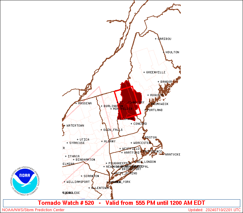
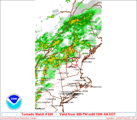
Tornado Watch Number 520
NWS Storm Prediction Center Norman OK
555 PM EDT Wed Jul 10 2024
The NWS Storm Prediction Center has issued a
* Tornado Watch for portions of
Western Maine
Northern and Central New Hampshire
* Effective this Wednesday afternoon from 555 PM until Midnight
EDT.
* Primary threats include...
A couple tornadoes possible
Isolated damaging wind gusts to 70 mph possible
SUMMARY...Thunderstorms will spread eastward from Vermont through
this evening. The strongest activity should pose some threat for a
couple of tornadoes, along with strong to locally damaging winds.
The tornado watch area is approximately along and 50 statute miles
north and south of a line from 35 miles west of Mount Washington NH
to 30 miles east of Mount Washington NH. For a complete depiction of
the watch see the associated watch outline update (WOUS64 KWNS
WOU0).
PRECAUTIONARY/PREPAREDNESS ACTIONS...
REMEMBER...A Tornado Watch means conditions are favorable for
tornadoes and severe thunderstorms in and close to the watch
area. Persons in these areas should be on the lookout for
threatening weather conditions and listen for later statements
and possible warnings.
&&
OTHER WATCH INFORMATION...CONTINUE...WW 517...WW 518...WW 519...
AVIATION...Tornadoes and a few severe thunderstorms with hail
surface and aloft to 1 inch. Extreme turbulence and surface wind
gusts to 60 knots. A few cumulonimbi with maximum tops to 500. Mean
storm motion vector 25030.
...Gleason
   SEL0

   URGENT - IMMEDIATE BROADCAST REQUESTED
   Tornado Watch Number 520
   NWS Storm Prediction Center Norman OK
   555 PM EDT Wed Jul 10 2024

   The NWS Storm Prediction Center has issued a

   * Tornado Watch for portions of
     Western Maine
     Northern and Central New Hampshire

   * Effective this Wednesday afternoon from 555 PM until Midnight
     EDT.

   * Primary threats include...
     A couple tornadoes possible
     Isolated damaging wind gusts to 70 mph possible

   SUMMARY...Thunderstorms will spread eastward from Vermont through
   this evening. The strongest activity should pose some threat for a
   couple of tornadoes, along with strong to locally damaging winds.

   The tornado watch area is approximately along and 50 statute miles
   north and south of a line from 35 miles west of Mount Washington NH
   to 30 miles east of Mount Washington NH. For a complete depiction of
   the watch see the associated watch outline update (WOUS64 KWNS
   WOU0).

   PRECAUTIONARY/PREPAREDNESS ACTIONS...

   REMEMBER...A Tornado Watch means conditions are favorable for
   tornadoes and severe thunderstorms in and close to the watch
   area. Persons in these areas should be on the lookout for
   threatening weather conditions and listen for later statements
   and possible warnings.

   &&

   OTHER WATCH INFORMATION...CONTINUE...WW 517...WW 518...WW 519...

   AVIATION...Tornadoes and a few severe thunderstorms with hail
   surface and aloft to 1 inch. Extreme turbulence and surface wind
   gusts to 60 knots. A few cumulonimbi with maximum tops to 500. Mean
   storm motion vector 25030.

   ...Gleason
 Note:
The Aviation Watch (SAW) product is an approximation to the watch area.
The actual watch is depicted by the shaded areas.
Note:
The Aviation Watch (SAW) product is an approximation to the watch area.
The actual watch is depicted by the shaded areas.
   SAW0
   WW 520 TORNADO ME NH 102155Z - 110400Z
   AXIS..50 STATUTE MILES NORTH AND SOUTH OF LINE..
   35W MWN/MOUNT WASHINGTON NH/ - 30E MWN/MOUNT WASHINGTON NH/
   ..AVIATION COORDS.. 45NM N/S /24E MPV - 50N ENE/
   HAIL SURFACE AND ALOFT..1 INCH. WIND GUSTS..60 KNOTS.
   MAX TOPS TO 500. MEAN STORM MOTION VECTOR 25030.

   LAT...LON 44997201 44997069 43547069 43547201

   THIS IS AN APPROXIMATION TO THE WATCH AREA.  FOR A
   COMPLETE DEPICTION OF THE WATCH SEE WOUS64 KWNS
   FOR WOU0.
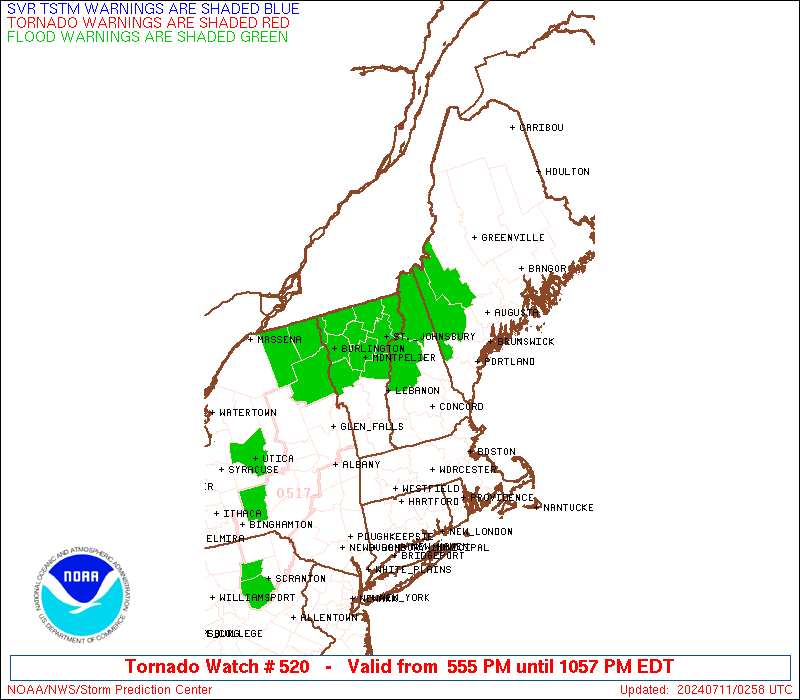
Watch 520 Status Report Messages:
STATUS REPORT #3 ON WW 520

VALID 110215Z - 110340Z

SEVERE WEATHER THREAT CONTINUES RIGHT OF A LINE FROM 15 NE MPV TO
35 E BML.

..LEITMAN..07/11/24

ATTN...WFO...GYX...

&&

STATUS REPORT FOR WT 520

SEVERE WEATHER THREAT CONTINUES FOR THE FOLLOWING AREAS

MEC017-110340-

ME
.    MAINE COUNTIES INCLUDED ARE

OXFORD
$$


NHC001-003-009-110340-

NH
.    NEW HAMPSHIRE COUNTIES INCLUDED ARE

BELKNAP 	     CARROLL		 GRAFTON
$$


THE WATCH STATUS MESSAGE IS FOR GUIDANCE PURPOSES ONLY.  PLEASE
REFER TO WATCH COUNTY NOTIFICATION STATEMENTS FOR OFFICIAL
INFORMATION ON COUNTIES...INDEPENDENT CITIES AND MARINE ZONES
CLEARED FROM SEVERE THUNDERSTORM AND TORNADO WATCHES.
$$

STATUS REPORT #2 ON WW 520

VALID 110055Z - 110140Z

THE SEVERE WEATHER THREAT CONTINUES ACROSS THE ENTIRE WATCH AREA.

..LEITMAN..07/11/24

ATTN...WFO...GYX...

&&

STATUS REPORT FOR WT 520

SEVERE WEATHER THREAT CONTINUES FOR THE FOLLOWING AREAS

MEC017-110140-

ME
.    MAINE COUNTIES INCLUDED ARE

OXFORD
$$


NHC001-003-007-009-110140-

NH
.    NEW HAMPSHIRE COUNTIES INCLUDED ARE

BELKNAP 	     CARROLL		 COOS
GRAFTON
$$


THE WATCH STATUS MESSAGE IS FOR GUIDANCE PURPOSES ONLY.  PLEASE
REFER TO WATCH COUNTY NOTIFICATION STATEMENTS FOR OFFICIAL
INFORMATION ON COUNTIES...INDEPENDENT CITIES AND MARINE ZONES
CLEARED FROM SEVERE THUNDERSTORM AND TORNADO WATCHES.
$$

STATUS REPORT #1 ON WW 520

VALID 110005Z - 110140Z

THE SEVERE WEATHER THREAT CONTINUES ACROSS THE ENTIRE WATCH AREA.

..LYONS..07/11/24

ATTN...WFO...GYX...

&&

STATUS REPORT FOR WT 520

SEVERE WEATHER THREAT CONTINUES FOR THE FOLLOWING AREAS

MEC017-110140-

ME
.    MAINE COUNTIES INCLUDED ARE

OXFORD
$$


NHC001-003-007-009-110140-

NH
.    NEW HAMPSHIRE COUNTIES INCLUDED ARE

BELKNAP 	     CARROLL		 COOS
GRAFTON
$$


THE WATCH STATUS MESSAGE IS FOR GUIDANCE PURPOSES ONLY.  PLEASE
REFER TO WATCH COUNTY NOTIFICATION STATEMENTS FOR OFFICIAL
INFORMATION ON COUNTIES...INDEPENDENT CITIES AND MARINE ZONES
CLEARED FROM SEVERE THUNDERSTORM AND TORNADO WATCHES.
$$
Note:
Click for Complete Product Text.
Tornadoes
Probability of 2 or more tornadoes
|
Mod (40%)
|
Probability of 1 or more strong (EF2-EF5) tornadoes
|
Low (20%)
|
Wind
Probability of 10 or more severe wind events
|
Mod (30%)
|
Probability of 1 or more wind events > 65 knots
|
Low (10%)
|
Hail
Probability of 10 or more severe hail events
|
Low (<5%)
|
Probability of 1 or more hailstones > 2 inches
|
Low (<5%)
|
Combined Severe Hail/Wind
Probability of 6 or more combined severe hail/wind events
|
Mod (50%)
|
For each watch, probabilities for particular events inside the watch
(listed above in each table) are determined by the issuing forecaster.
The "Low" category contains probability values ranging from less than 2%
to 20% (EF2-EF5 tornadoes), less than 5% to 20% (all other probabilities),
"Moderate" from 30% to 60%, and "High" from 70% to greater than 95%.
High values are bolded and lighter in color to provide awareness of
an increased threat for a particular event.


 @NWSSPC