 Note:
The expiration time in the watch graphic is amended if the watch is
replaced, cancelled or extended.
Note:
Note:
The expiration time in the watch graphic is amended if the watch is
replaced, cancelled or extended.
Note: Click for
Watch Status Reports.
SEL9
URGENT - IMMEDIATE BROADCAST REQUESTED
Severe Thunderstorm Watch Number 469
NWS Storm Prediction Center Norman OK
615 PM EDT Wed Jun 26 2024
The NWS Storm Prediction Center has issued a
* Severe Thunderstorm Watch for portions of
Connecticut
Much of New Jersey
Southeast New York and Long Island
Eastern Pennsylvania
Coastal Waters
* Effective this Wednesday night from 615 PM until Midnight EDT.
* Primary threats include...
Scattered damaging wind gusts to 65 mph possible
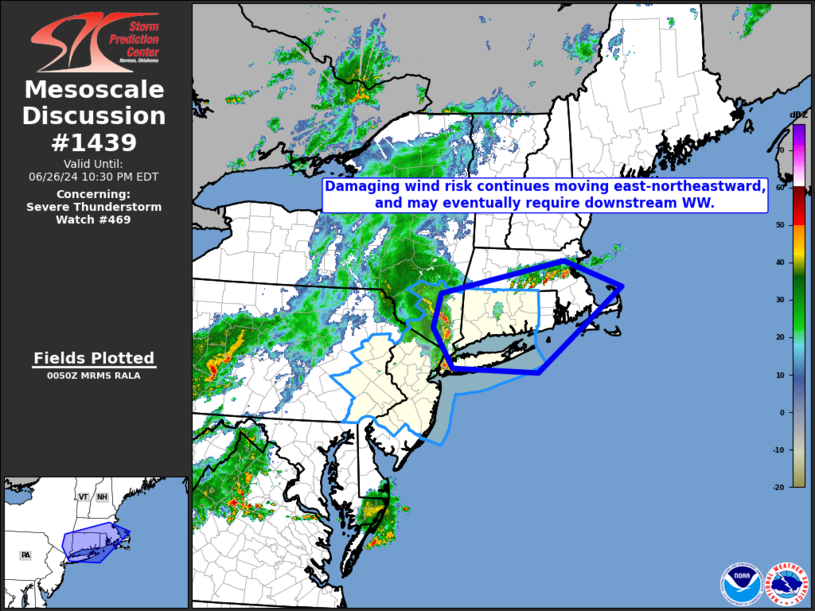
SUMMARY...A band of strong to severe thunderstorms is forecast to
move east into and across much of the Watch area this evening. A
risk for strong to severe gusts (50-65 mph) capable of wind damage
will potentially accompany the stronger thunderstorms. An isolated
threat for large hail (1 to 1.5 inches in diameter) may exist with
any discrete and intense thunderstorms.
The severe thunderstorm watch area is approximately along and 75
statute miles east and west of a line from 15 miles west northwest
of Windsor Locks CT to 10 miles southwest of Philadelphia PA. For a
complete depiction of the watch see the associated watch outline
update (WOUS64 KWNS WOU9).
PRECAUTIONARY/PREPAREDNESS ACTIONS...
REMEMBER...A Severe Thunderstorm Watch means conditions are
favorable for severe thunderstorms in and close to the watch area.
Persons in these areas should be on the lookout for threatening
weather conditions and listen for later statements and possible
warnings. Severe thunderstorms can and occasionally do produce
tornadoes.
&&
OTHER WATCH INFORMATION...CONTINUE...WW 464...WW 466...WW
467...WW 468...
AVIATION...A few severe thunderstorms with hail surface and aloft to
1.5 inches. Extreme turbulence and surface wind gusts to 55 knots. A
few cumulonimbi with maximum tops to 450. Mean storm motion vector
25040.
...Smith
 Note:
The Aviation Watch (SAW) product is an approximation to the watch area.
The actual watch is depicted by the shaded areas.
Note:
The Aviation Watch (SAW) product is an approximation to the watch area.
The actual watch is depicted by the shaded areas.
   SAW9
   WW 469 SEVERE TSTM CT NJ NY PA CW 262215Z - 270400Z
   AXIS..75 STATUTE MILES EAST AND WEST OF LINE..
   15WNW BDL/WINDSOR LOCKS CT/ - 10SW PHL/PHILADELPHIA PA/
   ..AVIATION COORDS.. 65NM E/W /10WNW BDL - 44W CYN/
   HAIL SURFACE AND ALOFT..1.5 INCHES. WIND GUSTS..55 KNOTS.
   MAX TOPS TO 450. MEAN STORM MOTION VECTOR 25040.

   LAT...LON 42007144 39757397 39757679 42007436

   THIS IS AN APPROXIMATION TO THE WATCH AREA.  FOR A
   COMPLETE DEPICTION OF THE WATCH SEE WOUS64 KWNS
   FOR WOU9.
Watch 469 Status Report Messages:
STATUS REPORT #2 ON WW 469

VALID 270245Z - 270340Z

SEVERE WEATHER THREAT CONTINUES RIGHT OF A LINE FROM 25 W ABE TO
20 W GON TO 10 SE BAF.

..GOSS..06/27/24

ATTN...WFO...OKX...BOX...ALY...PHI...

&&

STATUS REPORT FOR WS 469

SEVERE WEATHER THREAT CONTINUES FOR THE FOLLOWING AREAS

CTC001-007-009-011-013-015-270340-

CT
.    CONNECTICUT COUNTIES INCLUDED ARE

FAIRFIELD	     MIDDLESEX		 NEW HAVEN
NEW LONDON	     TOLLAND		 WINDHAM
$$


NJC003-005-007-013-015-017-019-021-023-025-027-029-031-035-039-
041-270340-

NJ
.    NEW JERSEY COUNTIES INCLUDED ARE

BERGEN		     BURLINGTON 	 CAMDEN
ESSEX		     GLOUCESTER 	 HUDSON
HUNTERDON	     MERCER		 MIDDLESEX
MONMOUTH	     MORRIS		 OCEAN
PASSAIC 	     SOMERSET		 UNION
WARREN
$$


NYC005-047-059-061-081-085-087-103-119-270340-

NY
.    NEW YORK COUNTIES INCLUDED ARE

BRONX		     KINGS		 NASSAU
NEW YORK (MANHATTAN) QUEENS		 RICHMOND
ROCKLAND	     SUFFOLK		 WESTCHESTER
$$


PAC011-017-029-045-077-091-095-101-270340-

PA
.    PENNSYLVANIA COUNTIES INCLUDED ARE

BERKS		     BUCKS		 CHESTER
DELAWARE	     LEHIGH		 MONTGOMERY
NORTHAMPTON	     PHILADELPHIA
$$


ANZ331-332-335-338-340-345-350-353-355-450-451-270340-

CW

.    ADJACENT COASTAL WATERS INCLUDED ARE

LONG ISLAND SOUND EAST OF NEW HAVEN CT/PORT JEFFERSON NY TO THE
MOUTH OF THE CONNECTICUT RIVER

LONG ISLAND SOUND EAST OF THE MOUTH OF THE CONNECTICUT RIVER

LONG ISLAND SOUND WEST OF NEW HAVEN CT/PORT JEFFERSON NY

NEW YORK HARBOR

PECONIC AND GARDINERS BAYS

SOUTH SHORE BAYS FROM JONES INLET THROUGH SHINNECOCK BAY

MORICHES INLET NY TO MONTAUK POINT NY OUT 20 NM

FIRE ISLAND INLET NY TO MORICHES INLET NY OUT 20 NM

SANDY HOOK NJ TO FIRE ISLAND INLET NY OUT 20 NM

COASTAL WATERS FROM SANDY HOOK TO MANASQUAN INLET NJ OUT 20 NM

COASTAL WATERS FROM MANASQUAN INLET TO LITTLE EGG INLET NJ OUT 20
NM

$$
THE WATCH STATUS MESSAGE IS FOR GUIDANCE PURPOSES ONLY.  PLEASE
REFER TO WATCH COUNTY NOTIFICATION STATEMENTS FOR OFFICIAL
INFORMATION ON COUNTIES...INDEPENDENT CITIES AND MARINE ZONES
CLEARED FROM SEVERE THUNDERSTORM AND TORNADO WATCHES.
$$

STATUS REPORT #1 ON WW 469

VALID 270145Z - 270240Z

SEVERE WEATHER THREAT CONTINUES RIGHT OF A LINE FROM 30 W ABE TO
25 N EWR TO 10 SSE POU TO 25 SSW PSF.

..GOSS..06/27/24

ATTN...WFO...OKX...BOX...ALY...PHI...

&&

STATUS REPORT FOR WS 469

SEVERE WEATHER THREAT CONTINUES FOR THE FOLLOWING AREAS

CTC001-003-005-007-009-011-013-015-270240-

CT
.    CONNECTICUT COUNTIES INCLUDED ARE

FAIRFIELD	     HARTFORD		 LITCHFIELD
MIDDLESEX	     NEW HAVEN		 NEW LONDON
TOLLAND 	     WINDHAM
$$


NJC003-005-007-013-015-017-019-021-023-025-027-029-031-035-039-
041-270240-

NJ
.    NEW JERSEY COUNTIES INCLUDED ARE

BERGEN		     BURLINGTON 	 CAMDEN
ESSEX		     GLOUCESTER 	 HUDSON
HUNTERDON	     MERCER		 MIDDLESEX
MONMOUTH	     MORRIS		 OCEAN
PASSAIC 	     SOMERSET		 UNION
WARREN
$$


NYC005-047-059-061-081-085-087-103-119-270240-

NY
.    NEW YORK COUNTIES INCLUDED ARE

BRONX		     KINGS		 NASSAU
NEW YORK (MANHATTAN) QUEENS		 RICHMOND
ROCKLAND	     SUFFOLK		 WESTCHESTER
$$


PAC011-017-029-045-077-091-095-101-270240-

PA
.    PENNSYLVANIA COUNTIES INCLUDED ARE

BERKS		     BUCKS		 CHESTER
DELAWARE	     LEHIGH		 MONTGOMERY
NORTHAMPTON	     PHILADELPHIA
$$


ANZ331-332-335-338-340-345-350-353-355-450-451-270240-

CW

.    ADJACENT COASTAL WATERS INCLUDED ARE

LONG ISLAND SOUND EAST OF NEW HAVEN CT/PORT JEFFERSON NY TO THE
MOUTH OF THE CONNECTICUT RIVER

LONG ISLAND SOUND EAST OF THE MOUTH OF THE CONNECTICUT RIVER

LONG ISLAND SOUND WEST OF NEW HAVEN CT/PORT JEFFERSON NY

NEW YORK HARBOR

PECONIC AND GARDINERS BAYS

SOUTH SHORE BAYS FROM JONES INLET THROUGH SHINNECOCK BAY

MORICHES INLET NY TO MONTAUK POINT NY OUT 20 NM

FIRE ISLAND INLET NY TO MORICHES INLET NY OUT 20 NM

SANDY HOOK NJ TO FIRE ISLAND INLET NY OUT 20 NM

COASTAL WATERS FROM SANDY HOOK TO MANASQUAN INLET NJ OUT 20 NM

COASTAL WATERS FROM MANASQUAN INLET TO LITTLE EGG INLET NJ OUT 20
NM

$$
THE WATCH STATUS MESSAGE IS FOR GUIDANCE PURPOSES ONLY.  PLEASE
REFER TO WATCH COUNTY NOTIFICATION STATEMENTS FOR OFFICIAL
INFORMATION ON COUNTIES...INDEPENDENT CITIES AND MARINE ZONES
CLEARED FROM SEVERE THUNDERSTORM AND TORNADO WATCHES.
$$
Note:
Click for Complete Product Text.
Tornadoes
Probability of 2 or more tornadoes
|
Low (10%)
|
Probability of 1 or more strong (EF2-EF5) tornadoes
|
Low (<2%)
|
Wind
Probability of 10 or more severe wind events
|
Mod (50%)
|
Probability of 1 or more wind events > 65 knots
|
Low (20%)
|
Hail
Probability of 10 or more severe hail events
|
Low (10%)
|
Probability of 1 or more hailstones > 2 inches
|
Low (10%)
|
Combined Severe Hail/Wind
Probability of 6 or more combined severe hail/wind events
|
Mod (60%)
|
For each watch, probabilities for particular events inside the watch
(listed above in each table) are determined by the issuing forecaster.
The "Low" category contains probability values ranging from less than 2%
to 20% (EF2-EF5 tornadoes), less than 5% to 20% (all other probabilities),
"Moderate" from 30% to 60%, and "High" from 70% to greater than 95%.
High values are bolded and lighter in color to provide awareness of
an increased threat for a particular event.


 @NWSSPC