Note:
The expiration time in the watch graphic is amended if the watch is
replaced, cancelled or extended.
Note:
Note:
The expiration time in the watch graphic is amended if the watch is
replaced, cancelled or extended.
Note: Click for
Watch Status Reports.
SEL7
URGENT - IMMEDIATE BROADCAST REQUESTED
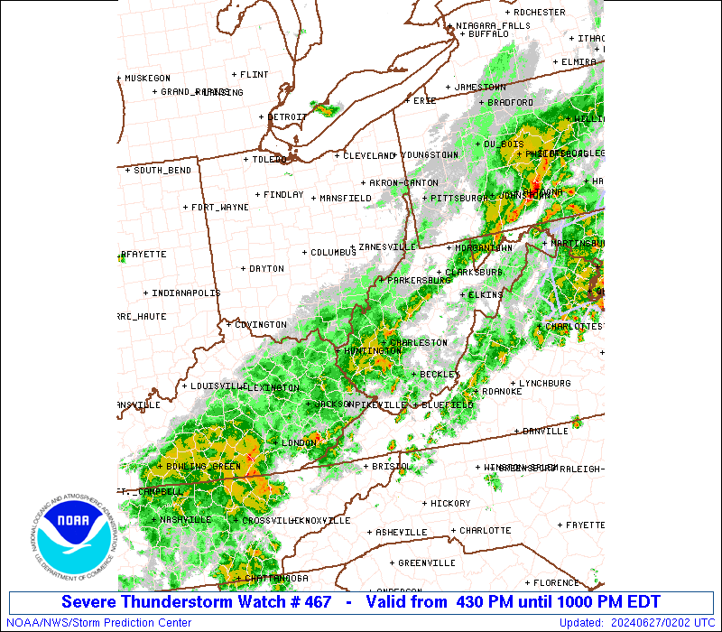
Severe Thunderstorm Watch Number 467
NWS Storm Prediction Center Norman OK
430 PM EDT Wed Jun 26 2024
The NWS Storm Prediction Center has issued a
* Severe Thunderstorm Watch for portions of
Eastern Kentucky
Southeast Ohio
Southwest Pennsylvania
Southwest Virginia
West Virginia
* Effective this Wednesday afternoon and evening from 430 PM
until 1000 PM EDT.
* Primary threats include...
Scattered damaging wind gusts to 70 mph likely
Scattered large hail events to 1 inch in diameter possible
SUMMARY...Thunderstorms are expected to increase in coverage this
afternoon from southwest Pennsylvania into eastern Kentucky and
track eastward across the watch area. The strongest cells will pose
a risk of locally damaging wind gusts.
The severe thunderstorm watch area is approximately along and 75
statute miles east and west of a line from 35 miles south of Jackson
KY to 35 miles northeast of Pittsburgh PA. For a complete depiction
of the watch see the associated watch outline update (WOUS64 KWNS
WOU7).
PRECAUTIONARY/PREPAREDNESS ACTIONS...
REMEMBER...A Severe Thunderstorm Watch means conditions are
favorable for severe thunderstorms in and close to the watch area.
Persons in these areas should be on the lookout for threatening
weather conditions and listen for later statements and possible
warnings. Severe thunderstorms can and occasionally do produce
tornadoes.
&&
OTHER WATCH INFORMATION...CONTINUE...WW 464...WW 465...WW 466...
AVIATION...A few severe thunderstorms with hail surface and aloft to
1 inch. Extreme turbulence and surface wind gusts to 60 knots. A few
cumulonimbi with maximum tops to 500. Mean storm motion vector
27030.
...Hart
 Note:
The Aviation Watch (SAW) product is an approximation to the watch area.
The actual watch is depicted by the shaded areas.
Note:
The Aviation Watch (SAW) product is an approximation to the watch area.
The actual watch is depicted by the shaded areas.
   SAW7
   WW 467 SEVERE TSTM KY OH PA VA WV 262030Z - 270200Z
   AXIS..75 STATUTE MILES EAST AND WEST OF LINE..
   35S JKL/JACKSON KY/ - 35NE PIT/PITTSBURGH PA/
   ..AVIATION COORDS.. 65NM E/W /35E LOZ - 21E EWC/
   HAIL SURFACE AND ALOFT..1 INCH. WIND GUSTS..60 KNOTS.
   MAX TOPS TO 500. MEAN STORM MOTION VECTOR 27030.

   LAT...LON 37038474 40848119 40847832 37038202

   THIS IS AN APPROXIMATION TO THE WATCH AREA.  FOR A
   COMPLETE DEPICTION OF THE WATCH SEE WOUS64 KWNS
   FOR WOU7.
Watch 467 Status Report Messages:
STATUS REPORT #2 ON WW 467

VALID 270135Z - 270240Z

SEVERE WEATHER THREAT CONTINUES RIGHT OF A LINE FROM 35 NNW LOZ
TO 15 N JKL TO 30 S PKB TO 30 SSE LBE.

..GOSS..06/27/24

ATTN...WFO...JKL...RLX...PBZ...

&&

STATUS REPORT FOR WS 467

SEVERE WEATHER THREAT CONTINUES FOR THE FOLLOWING AREAS

KYC025-051-071-095-109-115-119-121-125-127-131-133-153-159-189-
193-195-199-203-270240-

KY
.    KENTUCKY COUNTIES INCLUDED ARE

BREATHITT	     CLAY		 FLOYD
HARLAN		     JACKSON		 JOHNSON
KNOTT		     KNOX		 LAUREL
LAWRENCE	     LESLIE		 LETCHER
MAGOFFIN	     MARTIN		 OWSLEY
PERRY		     PIKE		 PULASKI
ROCKCASTLE
$$


VAC027-051-270240-

VA
.    VIRGINIA COUNTIES INCLUDED ARE

BUCHANAN	     DICKENSON
$$


WVC001-005-007-011-013-015-019-021-033-035-039-041-043-045-047-
049-059-067-075-077-079-081-083-087-091-093-097-099-101-109-
270240-

WV
.    WEST VIRGINIA COUNTIES INCLUDED ARE

BARBOUR 	     BOONE		 BRAXTON
CABELL		     CALHOUN		 CLAY
FAYETTE 	     GILMER		 HARRISON
JACKSON 	     KANAWHA		 LEWIS
LINCOLN 	     LOGAN		 MCDOWELL
MARION		     MINGO		 NICHOLAS
POCAHONTAS	     PRESTON		 PUTNAM
RALEIGH 	     RANDOLPH		 ROANE
TAYLOR		     TUCKER		 UPSHUR
WAYNE		     WEBSTER		 WYOMING
$$


THE WATCH STATUS MESSAGE IS FOR GUIDANCE PURPOSES ONLY.  PLEASE
REFER TO WATCH COUNTY NOTIFICATION STATEMENTS FOR OFFICIAL
INFORMATION ON COUNTIES...INDEPENDENT CITIES AND MARINE ZONES
CLEARED FROM SEVERE THUNDERSTORM AND TORNADO WATCHES.
$$

STATUS REPORT #1 ON WW 467

VALID 262255Z - 262340Z

SEVERE WEATHER THREAT CONTINUES RIGHT OF A LINE FROM 25 NW UNI TO
25 N PIT.

..GOSS..06/26/24

ATTN...WFO...JKL...RLX...PBZ...

&&

STATUS REPORT FOR WS 467

SEVERE WEATHER THREAT CONTINUES FOR THE FOLLOWING AREAS

KYC011-019-025-043-051-063-065-069-071-089-095-109-115-119-121-
125-127-129-131-133-153-159-165-173-175-189-193-195-197-199-203-
205-237-262340-

KY
.    KENTUCKY COUNTIES INCLUDED ARE

BATH		     BOYD		 BREATHITT
CARTER		     CLAY		 ELLIOTT
ESTILL		     FLEMING		 FLOYD
GREENUP 	     HARLAN		 JACKSON
JOHNSON 	     KNOTT		 KNOX
LAUREL		     LAWRENCE		 LEE
LESLIE		     LETCHER		 MAGOFFIN
MARTIN		     MENIFEE		 MONTGOMERY
MORGAN		     OWSLEY		 PERRY
PIKE		     POWELL		 PULASKI
ROCKCASTLE	     ROWAN		 WOLFE
$$


OHC009-013-053-059-067-079-081-087-105-111-115-121-127-163-167-
262340-

OH
.    OHIO COUNTIES INCLUDED ARE

ATHENS		     BELMONT		 GALLIA
GUERNSEY	     HARRISON		 JACKSON
JEFFERSON	     LAWRENCE		 MEIGS
MONROE		     MORGAN		 NOBLE
PERRY		     VINTON		 WASHINGTON
$$


PAC003-007-051-059-063-125-129-262340-

PA
.    PENNSYLVANIA COUNTIES INCLUDED ARE

ALLEGHENY	     BEAVER		 FAYETTE
GREENE		     INDIANA		 WASHINGTON
WESTMORELAND
$$


VAC027-051-262340-

VA
.    VIRGINIA COUNTIES INCLUDED ARE

BUCHANAN	     DICKENSON
$$


WVC001-005-007-009-011-013-015-017-019-021-029-033-035-039-041-
043-045-047-049-051-053-059-061-067-069-073-075-077-079-081-083-
085-087-091-093-095-097-099-101-103-105-107-109-262340-

WV
.    WEST VIRGINIA COUNTIES INCLUDED ARE

BARBOUR 	     BOONE		 BRAXTON
BROOKE		     CABELL		 CALHOUN
CLAY		     DODDRIDGE		 FAYETTE
GILMER		     HANCOCK		 HARRISON
JACKSON 	     KANAWHA		 LEWIS
LINCOLN 	     LOGAN		 MCDOWELL
MARION		     MARSHALL		 MASON
MINGO		     MONONGALIA 	 NICHOLAS
OHIO		     PLEASANTS		 POCAHONTAS
PRESTON 	     PUTNAM		 RALEIGH
RANDOLPH	     RITCHIE		 ROANE
TAYLOR		     TUCKER		 TYLER
UPSHUR		     WAYNE		 WEBSTER
WETZEL		     WIRT		 WOOD
WYOMING
$$


THE WATCH STATUS MESSAGE IS FOR GUIDANCE PURPOSES ONLY.  PLEASE
REFER TO WATCH COUNTY NOTIFICATION STATEMENTS FOR OFFICIAL
INFORMATION ON COUNTIES...INDEPENDENT CITIES AND MARINE ZONES
CLEARED FROM SEVERE THUNDERSTORM AND TORNADO WATCHES.
$$
Note:
Click for Complete Product Text.
Tornadoes
Probability of 2 or more tornadoes
|
Low (<5%)
|
Probability of 1 or more strong (EF2-EF5) tornadoes
|
Low (<2%)
|
Wind
Probability of 10 or more severe wind events
|
Mod (60%)
|
Probability of 1 or more wind events > 65 knots
|
Low (20%)
|
Hail
Probability of 10 or more severe hail events
|
Mod (40%)
|
Probability of 1 or more hailstones > 2 inches
|
Low (20%)
|
Combined Severe Hail/Wind
Probability of 6 or more combined severe hail/wind events
|
High (90%)
|
For each watch, probabilities for particular events inside the watch
(listed above in each table) are determined by the issuing forecaster.
The "Low" category contains probability values ranging from less than 2%
to 20% (EF2-EF5 tornadoes), less than 5% to 20% (all other probabilities),
"Moderate" from 30% to 60%, and "High" from 70% to greater than 95%.
High values are bolded and lighter in color to provide awareness of
an increased threat for a particular event.


 @NWSSPC