 Note:
The expiration time in the watch graphic is amended if the watch is
replaced, cancelled or extended.
Note:
Note:
The expiration time in the watch graphic is amended if the watch is
replaced, cancelled or extended.
Note: Click for
Watch Status Reports.
SEL6
URGENT - IMMEDIATE BROADCAST REQUESTED
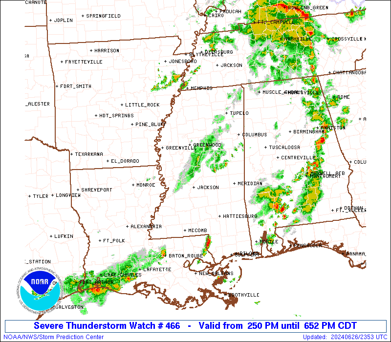
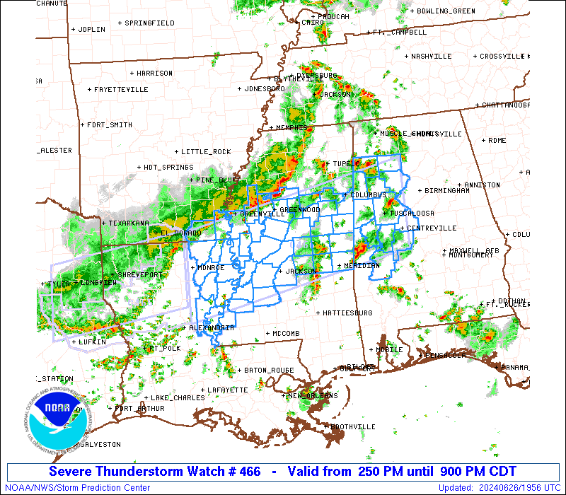
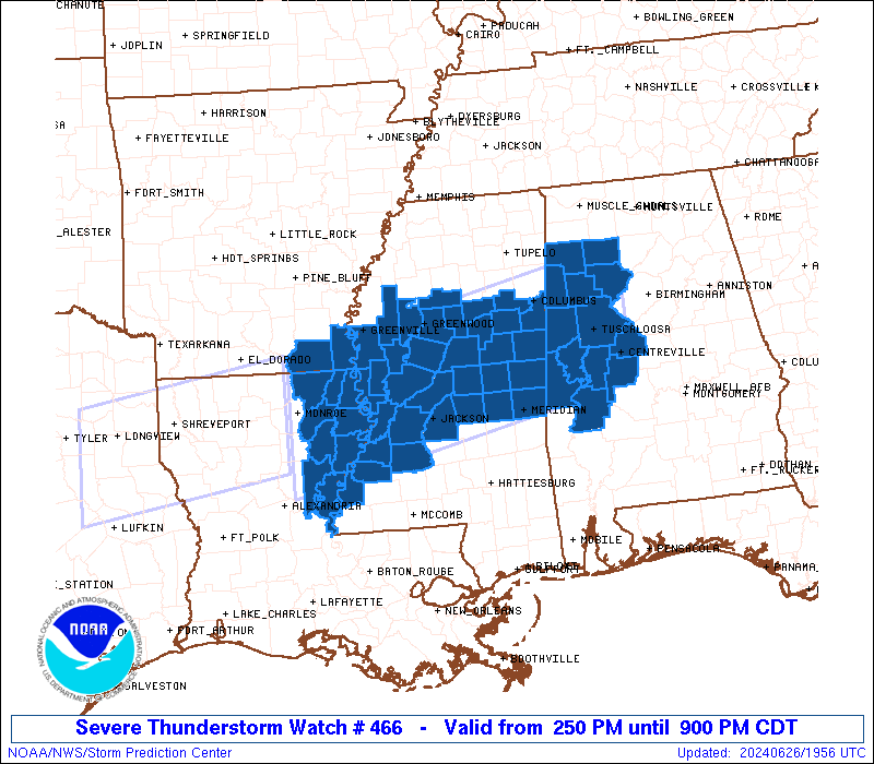
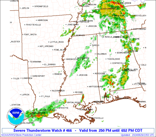
Severe Thunderstorm Watch Number 466
NWS Storm Prediction Center Norman OK
250 PM CDT Wed Jun 26 2024
The NWS Storm Prediction Center has issued a
* Severe Thunderstorm Watch for portions of
West Central Alabama
Southeast Arkansas
Northeast Louisiana
Central Mississippi
* Effective this Wednesday afternoon and evening from 250 PM
until 900 PM CDT.
* Primary threats include...
Scattered damaging wind gusts to 70 mph possible
Isolated large hail events to 1 inch in diameter possible
SUMMARY...A line of thunderstorms over southeast Arkansas will sag
southward into the watch area this afternoon, while other more
isolated cells affect western Alabama. Hot and humid conditions
will promote a risk of locally intense wind gusts with the stronger
cells.
The severe thunderstorm watch area is approximately along and 60
statute miles north and south of a line from 15 miles south
southwest of Monroe LA to 30 miles east northeast of Tuscaloosa AL.
For a complete depiction of the watch see the associated watch
outline update (WOUS64 KWNS WOU6).
PRECAUTIONARY/PREPAREDNESS ACTIONS...
REMEMBER...A Severe Thunderstorm Watch means conditions are
favorable for severe thunderstorms in and close to the watch area.
Persons in these areas should be on the lookout for threatening
weather conditions and listen for later statements and possible
warnings. Severe thunderstorms can and occasionally do produce
tornadoes.
&&
OTHER WATCH INFORMATION...CONTINUE...WW 464...WW 465...
AVIATION...A few severe thunderstorms with hail surface and aloft to
1 inch. Extreme turbulence and surface wind gusts to 60 knots. A few
cumulonimbi with maximum tops to 500. Mean storm motion vector
26035.
...Hart

   SEL6

   URGENT - IMMEDIATE BROADCAST REQUESTED
   Severe Thunderstorm Watch Number 466
   NWS Storm Prediction Center Norman OK
   250 PM CDT Wed Jun 26 2024

   The NWS Storm Prediction Center has issued a

   * Severe Thunderstorm Watch for portions of
     West Central Alabama
     Southeast Arkansas
     Northeast Louisiana
     Central Mississippi

   * Effective this Wednesday afternoon and evening from 250 PM
     until 900 PM CDT.

   * Primary threats include...
     Scattered damaging wind gusts to 70 mph possible
     Isolated large hail events to 1 inch in diameter possible

   SUMMARY...A line of thunderstorms over southeast Arkansas will sag
   southward into the watch area this afternoon, while other more
   isolated cells affect western Alabama.  Hot and humid conditions
   will promote a risk of locally intense wind gusts with the stronger
   cells.

   The severe thunderstorm watch area is approximately along and 60
   statute miles north and south of a line from 15 miles south
   southwest of Monroe LA to 30 miles east northeast of Tuscaloosa AL.
   For a complete depiction of the watch see the associated watch
   outline update (WOUS64 KWNS WOU6).

   PRECAUTIONARY/PREPAREDNESS ACTIONS...

   REMEMBER...A Severe Thunderstorm Watch means conditions are
   favorable for severe thunderstorms in and close to the watch area.
   Persons in these areas should be on the lookout for threatening
   weather conditions and listen for later statements and possible
   warnings. Severe thunderstorms can and occasionally do produce
   tornadoes.

   &&

   OTHER WATCH INFORMATION...CONTINUE...WW 464...WW 465...

   AVIATION...A few severe thunderstorms with hail surface and aloft to
   1 inch. Extreme turbulence and surface wind gusts to 60 knots. A few
   cumulonimbi with maximum tops to 500. Mean storm motion vector
   26035.

   ...Hart
 Note:
The Aviation Watch (SAW) product is an approximation to the watch area.
The actual watch is depicted by the shaded areas.
Note:
The Aviation Watch (SAW) product is an approximation to the watch area.
The actual watch is depicted by the shaded areas.
   SAW6
   WW 466 SEVERE TSTM AL AR LA MS 261950Z - 270200Z
   AXIS..60 STATUTE MILES NORTH AND SOUTH OF LINE..
   15SSW MLU/MONROE LA/ - 30ENE TCL/TUSCALOOSA AL/
   ..AVIATION COORDS.. 50NM N/S /13SSW MLU - 21SW VUZ/
   HAIL SURFACE AND ALOFT..1 INCH. WIND GUSTS..60 KNOTS.
   MAX TOPS TO 500. MEAN STORM MOTION VECTOR 26035.

   LAT...LON 33189213 34258714 32528714 31459213

   THIS IS AN APPROXIMATION TO THE WATCH AREA.  FOR A
   COMPLETE DEPICTION OF THE WATCH SEE WOUS64 KWNS
   FOR WOU6.
Watch 466 Status Report Messages:
STATUS REPORT #1 ON WW 466

VALID 262255Z - 262340Z

SEVERE WEATHER THREAT CONTINUES RIGHT OF A LINE FROM 25 N ESF TO
30 ESE GWO TO 40 S MSL.

..GOSS..06/26/24

ATTN...WFO...BMX...JAN...

&&

STATUS REPORT FOR WS 466

SEVERE WEATHER THREAT CONTINUES FOR THE FOLLOWING AREAS

ALC007-057-063-065-075-091-105-107-119-125-127-133-262340-

AL
.    ALABAMA COUNTIES INCLUDED ARE

BIBB		     FAYETTE		 GREENE
HALE		     LAMAR		 MARENGO
PERRY		     PICKENS		 SUMTER
TUSCALOOSA	     WALKER		 WINSTON
$$


LAC025-029-041-065-107-262340-

LA
.    LOUISIANA PARISHES INCLUDED ARE

CATAHOULA	     CONCORDIA		 FRANKLIN
MADISON 	     TENSAS
$$


MSC001-007-019-021-025-029-049-051-063-069-075-079-087-089-099-
101-103-105-121-123-149-159-163-262340-

MS
.    MISSISSIPPI COUNTIES INCLUDED ARE

ADAMS		     ATTALA		 CHOCTAW
CLAIBORNE	     CLAY		 COPIAH
HINDS		     HOLMES		 JEFFERSON
KEMPER		     LAUDERDALE 	 LEAKE
LOWNDES 	     MADISON		 NESHOBA
NEWTON		     NOXUBEE		 OKTIBBEHA
RANKIN		     SCOTT		 WARREN
WINSTON 	     YAZOO
$$


THE WATCH STATUS MESSAGE IS FOR GUIDANCE PURPOSES ONLY.  PLEASE
REFER TO WATCH COUNTY NOTIFICATION STATEMENTS FOR OFFICIAL
INFORMATION ON COUNTIES...INDEPENDENT CITIES AND MARINE ZONES
CLEARED FROM SEVERE THUNDERSTORM AND TORNADO WATCHES.
$$
Note:
Click for Complete Product Text.
Tornadoes
Probability of 2 or more tornadoes
|
Low (<5%)
|
Probability of 1 or more strong (EF2-EF5) tornadoes
|
Low (<2%)
|
Wind
Probability of 10 or more severe wind events
|
Mod (40%)
|
Probability of 1 or more wind events > 65 knots
|
Low (20%)
|
Hail
Probability of 10 or more severe hail events
|
Low (20%)
|
Probability of 1 or more hailstones > 2 inches
|
Low (10%)
|
Combined Severe Hail/Wind
Probability of 6 or more combined severe hail/wind events
|
Mod (60%)
|
For each watch, probabilities for particular events inside the watch
(listed above in each table) are determined by the issuing forecaster.
The "Low" category contains probability values ranging from less than 2%
to 20% (EF2-EF5 tornadoes), less than 5% to 20% (all other probabilities),
"Moderate" from 30% to 60%, and "High" from 70% to greater than 95%.
High values are bolded and lighter in color to provide awareness of
an increased threat for a particular event.


 @NWSSPC