 Note:
The expiration time in the watch graphic is amended if the watch is
replaced, cancelled or extended.
Note:
Note:
The expiration time in the watch graphic is amended if the watch is
replaced, cancelled or extended.
Note: Click for
Watch Status Reports.
SEL0
URGENT - IMMEDIATE BROADCAST REQUESTED
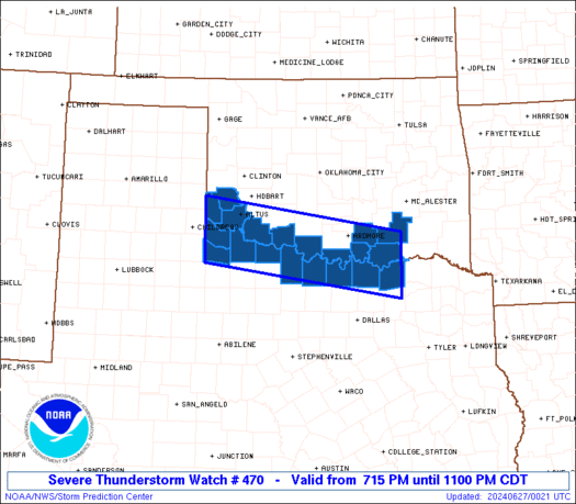
Severe Thunderstorm Watch Number 470
NWS Storm Prediction Center Norman OK
715 PM CDT Wed Jun 26 2024
The NWS Storm Prediction Center has issued a
* Severe Thunderstorm Watch for portions of
Southern Oklahoma
North Texas
* Effective this Wednesday evening from 715 PM until 1100 PM CDT.
* Primary threats include...
Scattered damaging winds and isolated significant gusts to 75
mph possible
Scattered large hail and isolated very large hail events to 2
inches in diameter possible
SUMMARY...Isolated to scattered severe thunderstorms are possible
this evening near the Texas-Oklahoma Red River Valley. The stronger
thunderstorms may yield a large to very large hail threat (1 to 2
inches in diameter) and severe gusts 60-75 mph. This thunderstorm
activity will likely wane by late evening into the early overnight.
The severe thunderstorm watch area is approximately along and 40
statute miles north and south of a line from 45 miles west southwest
of Altus OK to 30 miles east southeast of Durant OK. For a complete
depiction of the watch see the associated watch outline update
(WOUS64 KWNS WOU0).
PRECAUTIONARY/PREPAREDNESS ACTIONS...
REMEMBER...A Severe Thunderstorm Watch means conditions are
favorable for severe thunderstorms in and close to the watch area.
Persons in these areas should be on the lookout for threatening
weather conditions and listen for later statements and possible
warnings. Severe thunderstorms can and occasionally do produce
tornadoes.
&&
OTHER WATCH INFORMATION...CONTINUE...WW 464...WW 467...WW
468...WW 469...
AVIATION...A few severe thunderstorms with hail surface and aloft to
2 inches. Extreme turbulence and surface wind gusts to 65 knots. A
few cumulonimbi with maximum tops to 650. Mean storm motion vector
02020.
...Smith
 Note:
The Aviation Watch (SAW) product is an approximation to the watch area.
The actual watch is depicted by the shaded areas.
Note:
The Aviation Watch (SAW) product is an approximation to the watch area.
The actual watch is depicted by the shaded areas.
   SAW0
   WW 470 SEVERE TSTM OK TX 270015Z - 270400Z
   AXIS..40 STATUTE MILES NORTH AND SOUTH OF LINE..
   45WSW LTS/ALTUS OK/ - 30ESE DUA/DURANT OK/
   ..AVIATION COORDS.. 35NM N/S /14E CDS - 64S MLC/
   HAIL SURFACE AND ALOFT..2 INCHES. WIND GUSTS..65 KNOTS.
   MAX TOPS TO 650. MEAN STORM MOTION VECTOR 02020.

   LAT...LON 34980000 34369592 33209592 33820000

   THIS IS AN APPROXIMATION TO THE WATCH AREA.  FOR A
   COMPLETE DEPICTION OF THE WATCH SEE WOUS64 KWNS
   FOR WOU0.
Watch 470 Status Report Messages:
STATUS REPORT #2 ON WW 470

VALID 270240Z - 270340Z

SEVERE WEATHER THREAT CONTINUES RIGHT OF A LINE FROM 40 NW ADM TO
15 SSE ADM TO 5 N DAL.

..WENDT..06/27/24

ATTN...WFO...OUN...FWD...

&&

STATUS REPORT FOR WS 470

SEVERE WEATHER THREAT CONTINUES FOR THE FOLLOWING AREAS

OKC033-055-057-065-067-085-141-270340-

OK
.    OKLAHOMA COUNTIES INCLUDED ARE

COTTON		     GREER		 HARMON
JACKSON 	     JEFFERSON		 LOVE
TILLMAN
$$


TXC077-097-155-197-337-485-487-270340-

TX
.    TEXAS COUNTIES INCLUDED ARE

CLAY		     COOKE		 FOARD
HARDEMAN	     MONTAGUE		 WICHITA
WILBARGER
$$


THE WATCH STATUS MESSAGE IS FOR GUIDANCE PURPOSES ONLY.  PLEASE
REFER TO WATCH COUNTY NOTIFICATION STATEMENTS FOR OFFICIAL
INFORMATION ON COUNTIES...INDEPENDENT CITIES AND MARINE ZONES
CLEARED FROM SEVERE THUNDERSTORM AND TORNADO WATCHES.
$$

STATUS REPORT #1 ON WW 470

VALID 270140Z - 270240Z

THE SEVERE WEATHER THREAT CONTINUES ACROSS THE ENTIRE WATCH AREA.

FOR ADDITIONAL INFORMATION SEE MESOSCALE DISCUSSION 1441

..WENDT..06/27/24

ATTN...WFO...OUN...FWD...

&&

STATUS REPORT FOR WS 470

SEVERE WEATHER THREAT CONTINUES FOR THE FOLLOWING AREAS

OKC013-033-055-057-065-067-085-095-141-270240-

OK
.    OKLAHOMA COUNTIES INCLUDED ARE

BRYAN		     COTTON		 GREER
HARMON		     JACKSON		 JEFFERSON
LOVE		     MARSHALL		 TILLMAN
$$


TXC077-097-147-155-181-197-337-485-487-270240-

TX
.    TEXAS COUNTIES INCLUDED ARE

CLAY		     COOKE		 FANNIN
FOARD		     GRAYSON		 HARDEMAN
MONTAGUE	     WICHITA		 WILBARGER
$$


THE WATCH STATUS MESSAGE IS FOR GUIDANCE PURPOSES ONLY.  PLEASE
REFER TO WATCH COUNTY NOTIFICATION STATEMENTS FOR OFFICIAL
INFORMATION ON COUNTIES...INDEPENDENT CITIES AND MARINE ZONES
CLEARED FROM SEVERE THUNDERSTORM AND TORNADO WATCHES.
$$
Note:
Click for Complete Product Text.
Tornadoes
Probability of 2 or more tornadoes
|
Low (10%)
|
Probability of 1 or more strong (EF2-EF5) tornadoes
|
Low (<2%)
|
Wind
Probability of 10 or more severe wind events
|
Mod (40%)
|
Probability of 1 or more wind events > 65 knots
|
Mod (30%)
|
Hail
Probability of 10 or more severe hail events
|
Mod (40%)
|
Probability of 1 or more hailstones > 2 inches
|
Mod (30%)
|
Combined Severe Hail/Wind
Probability of 6 or more combined severe hail/wind events
|
High (70%)
|
For each watch, probabilities for particular events inside the watch
(listed above in each table) are determined by the issuing forecaster.
The "Low" category contains probability values ranging from less than 2%
to 20% (EF2-EF5 tornadoes), less than 5% to 20% (all other probabilities),
"Moderate" from 30% to 60%, and "High" from 70% to greater than 95%.
High values are bolded and lighter in color to provide awareness of
an increased threat for a particular event.


 @NWSSPC


