Note:
The expiration time in the watch graphic is amended if the watch is
replaced, cancelled or extended.
Note:
Note:
The expiration time in the watch graphic is amended if the watch is
replaced, cancelled or extended.
Note: Click for
Watch Status Reports.
SEL6
URGENT - IMMEDIATE BROADCAST REQUESTED
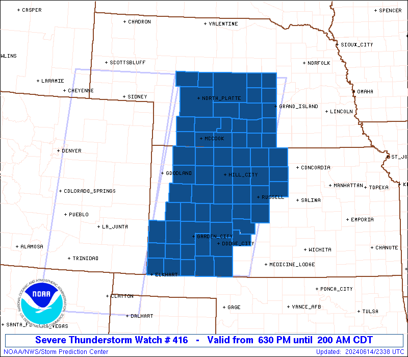
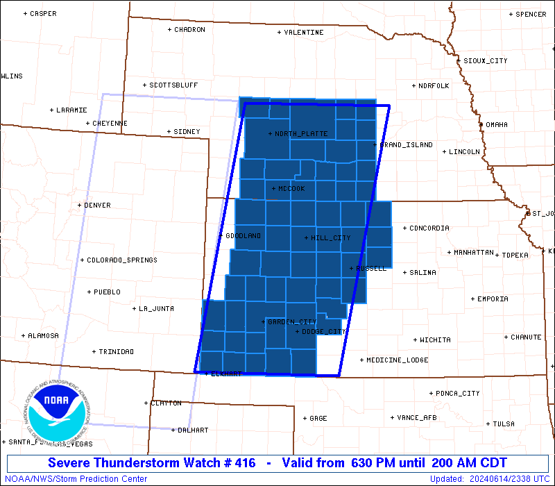
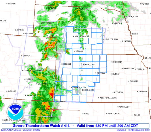
Severe Thunderstorm Watch Number 416
NWS Storm Prediction Center Norman OK
630 PM CDT Fri Jun 14 2024
The NWS Storm Prediction Center has issued a
* Severe Thunderstorm Watch for portions of
Western and Central Kansas
Central Nebraska
* Effective this Friday night and Saturday morning from 630 PM
until 200 AM CDT.
* Primary threats include...
Scattered damaging winds likely with isolated significant gusts
to 80 mph possible
Isolated large hail events to 1.5 inches in diameter possible
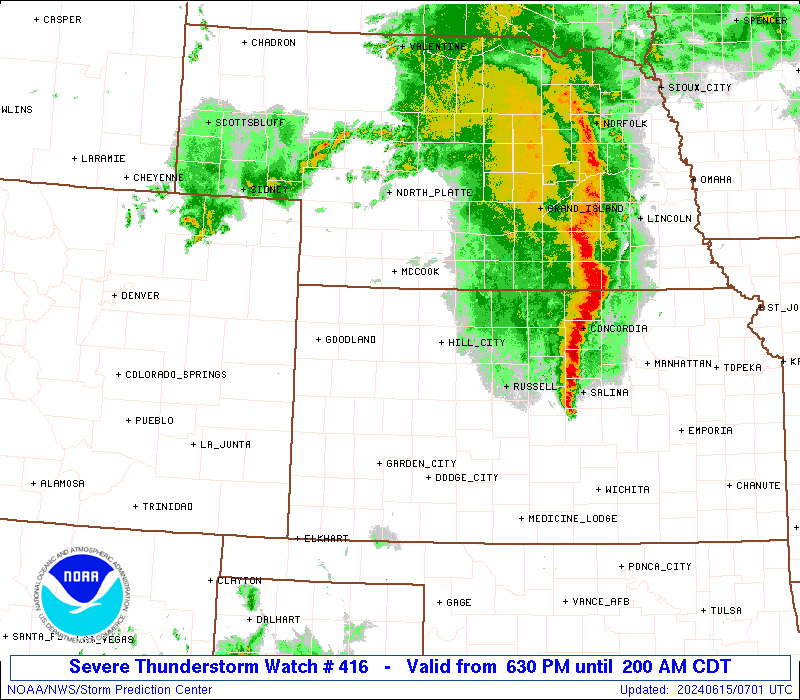
SUMMARY...Several clusters and linear bands of storms will move east
into the Watch area this evening. As the storms encounter
increasing moisture with eastward extent into western Kansas,
further upscale growth into a larger squall line is forecast this
evening. Severe gusts (60-80 mph) will be the primary hazard with
the stronger storms.
The severe thunderstorm watch area is approximately along and 85
statute miles east and west of a line from 15 miles north of Broken
Bow NE to 20 miles east of Liberal KS. For a complete depiction of
the watch see the associated watch outline update (WOUS64 KWNS
WOU6).
PRECAUTIONARY/PREPAREDNESS ACTIONS...
REMEMBER...A Severe Thunderstorm Watch means conditions are
favorable for severe thunderstorms in and close to the watch area.
Persons in these areas should be on the lookout for threatening
weather conditions and listen for later statements and possible
warnings. Severe thunderstorms can and occasionally do produce
tornadoes.
&&
OTHER WATCH INFORMATION...CONTINUE...WW 413...WW 414...WW 415...
AVIATION...A few severe thunderstorms with hail surface and aloft to
1.5 inches. Extreme turbulence and surface wind gusts to 70 knots. A
few cumulonimbi with maximum tops to 500. Mean storm motion vector
24035.
...Smith
   SEL6

   URGENT - IMMEDIATE BROADCAST REQUESTED
   Severe Thunderstorm Watch Number 416
   NWS Storm Prediction Center Norman OK
   630 PM CDT Fri Jun 14 2024

   The NWS Storm Prediction Center has issued a

   * Severe Thunderstorm Watch for portions of
     Western and Central Kansas
     Central Nebraska

   * Effective this Friday night and Saturday morning from 630 PM
     until 200 AM CDT.

   * Primary threats include...
     Scattered damaging winds likely with isolated significant gusts
       to 80 mph possible
     Isolated large hail events to 1.5 inches in diameter possible

   SUMMARY...Several clusters and linear bands of storms will move east
   into the Watch area this evening.  As the storms encounter
   increasing moisture with eastward extent into western Kansas,
   further upscale growth into a larger squall line is forecast this
   evening.  Severe gusts (60-80 mph) will be the primary hazard with
   the stronger storms.

   The severe thunderstorm watch area is approximately along and 85
   statute miles east and west of a line from 15 miles north of Broken
   Bow NE to 20 miles east of Liberal KS. For a complete depiction of
   the watch see the associated watch outline update (WOUS64 KWNS
   WOU6).

   PRECAUTIONARY/PREPAREDNESS ACTIONS...

   REMEMBER...A Severe Thunderstorm Watch means conditions are
   favorable for severe thunderstorms in and close to the watch area.
   Persons in these areas should be on the lookout for threatening
   weather conditions and listen for later statements and possible
   warnings. Severe thunderstorms can and occasionally do produce
   tornadoes.

   &&

   OTHER WATCH INFORMATION...CONTINUE...WW 413...WW 414...WW 415...

   AVIATION...A few severe thunderstorms with hail surface and aloft to
   1.5 inches. Extreme turbulence and surface wind gusts to 70 knots. A
   few cumulonimbi with maximum tops to 500. Mean storm motion vector
   24035.

   ...Smith
 Note:
The Aviation Watch (SAW) product is an approximation to the watch area.
The actual watch is depicted by the shaded areas.
Note:
The Aviation Watch (SAW) product is an approximation to the watch area.
The actual watch is depicted by the shaded areas.
   SAW6
   WW 416 SEVERE TSTM KS NE 142330Z - 150700Z
   AXIS..85 STATUTE MILES EAST AND WEST OF LINE..
   15N BBW/BROKEN BOW NE/ - 20E LBL/LIBERAL KS/
   ..AVIATION COORDS.. 75NM E/W /58SSE ANW - 17E LBL/
   HAIL SURFACE AND ALOFT..1.5 INCHES. WIND GUSTS..70 KNOTS.
   MAX TOPS TO 500. MEAN STORM MOTION VECTOR 24035.

   LAT...LON 41649798 37039907 37030215 41640128

   THIS IS AN APPROXIMATION TO THE WATCH AREA.  FOR A
   COMPLETE DEPICTION OF THE WATCH SEE WOUS64 KWNS
   FOR WOU6.
Watch 416 Status Report Messages:
STATUS REPORT #6 ON WW 416

VALID 150535Z - 150640Z

SEVERE WEATHER THREAT CONTINUES RIGHT OF A LINE FROM 20 ESE RSL
TO 25 WNW GRI TO 5 WSW BUB.

..LEITMAN..06/15/24

ATTN...WFO...ICT...DDC...GLD...GID...LBF...

&&

STATUS REPORT FOR WS 416

SEVERE WEATHER THREAT CONTINUES FOR THE FOLLOWING AREAS

KSC089-105-123-150640-

KS
.    KANSAS COUNTIES INCLUDED ARE

JEWELL		     LINCOLN		 MITCHELL
$$


NEC001-077-079-093-175-181-150640-

NE
.    NEBRASKA COUNTIES INCLUDED ARE

ADAMS		     GREELEY		 HALL
HOWARD		     VALLEY		 WEBSTER
$$


THE WATCH STATUS MESSAGE IS FOR GUIDANCE PURPOSES ONLY.  PLEASE
REFER TO WATCH COUNTY NOTIFICATION STATEMENTS FOR OFFICIAL
INFORMATION ON COUNTIES...INDEPENDENT CITIES AND MARINE ZONES
CLEARED FROM SEVERE THUNDERSTORM AND TORNADO WATCHES.
$$

STATUS REPORT #5 ON WW 416

VALID 150450Z - 150540Z

SEVERE WEATHER THREAT CONTINUES RIGHT OF A LINE FROM 30 S RSL TO
25 NW BBW.

..SPC..06/15/24

ATTN...WFO...ICT...DDC...GLD...GID...LBF...

&&

STATUS REPORT FOR WS 416

SEVERE WEATHER THREAT CONTINUES FOR THE FOLLOWING AREAS

KSC009-089-105-123-141-167-183-150540-

KS
.    KANSAS COUNTIES INCLUDED ARE

BARTON		     JEWELL		 LINCOLN
MITCHELL	     OSBORNE		 RUSSELL
SMITH
$$


NEC001-019-041-047-061-077-079-093-099-163-175-181-150540-

NE
.    NEBRASKA COUNTIES INCLUDED ARE

ADAMS		     BUFFALO		 CUSTER
DAWSON		     FRANKLIN		 GREELEY
HALL		     HOWARD		 KEARNEY
SHERMAN 	     VALLEY		 WEBSTER
$$


THE WATCH STATUS MESSAGE IS FOR GUIDANCE PURPOSES ONLY.  PLEASE
REFER TO WATCH COUNTY NOTIFICATION STATEMENTS FOR OFFICIAL
INFORMATION ON COUNTIES...INDEPENDENT CITIES AND MARINE ZONES
CLEARED FROM SEVERE THUNDERSTORM AND TORNADO WATCHES.
$$

STATUS REPORT #4 ON WW 416

VALID 150325Z - 150440Z

SEVERE WEATHER THREAT CONTINUES RIGHT OF A LINE FROM 30 NNW P28
TO 40 NNW DDC TO 10 SE HLC TO 35 N HLC TO 25 SW MHN.

..THORNTON..06/15/24

ATTN...WFO...ICT...DDC...GLD...GID...LBF...

&&

STATUS REPORT FOR WS 416

SEVERE WEATHER THREAT CONTINUES FOR THE FOLLOWING AREAS

KSC009-051-089-105-123-135-137-141-145-147-163-165-167-183-195-
150440-

KS
.    KANSAS COUNTIES INCLUDED ARE

BARTON		     ELLIS		 JEWELL
LINCOLN 	     MITCHELL		 NESS
NORTON		     OSBORNE		 PAWNEE
PHILLIPS	     ROOKS		 RUSH
RUSSELL 	     SMITH		 TREGO
$$


NEC001-019-041-047-061-063-065-073-077-079-083-093-099-111-113-
117-137-163-175-181-150440-

NE
.    NEBRASKA COUNTIES INCLUDED ARE

ADAMS		     BUFFALO		 CUSTER
DAWSON		     FRANKLIN		 FRONTIER
FURNAS		     GOSPER		 GREELEY
HALL		     HARLAN		 HOWARD
KEARNEY 	     LINCOLN		 LOGAN
MCPHERSON	     PHELPS		 SHERMAN
VALLEY		     WEBSTER
$$


THE WATCH STATUS MESSAGE IS FOR GUIDANCE PURPOSES ONLY.  PLEASE
REFER TO WATCH COUNTY NOTIFICATION STATEMENTS FOR OFFICIAL
INFORMATION ON COUNTIES...INDEPENDENT CITIES AND MARINE ZONES
CLEARED FROM SEVERE THUNDERSTORM AND TORNADO WATCHES.
$$

STATUS REPORT #3 ON WW 416

VALID 150240Z - 150340Z

SEVERE WEATHER THREAT CONTINUES RIGHT OF A LINE FROM 60 S DDC TO
35 N IML.

..THORNTON..06/15/24

ATTN...WFO...ICT...DDC...GLD...GID...LBF...

&&

STATUS REPORT FOR WS 416

SEVERE WEATHER THREAT CONTINUES FOR THE FOLLOWING AREAS

KSC009-025-039-047-051-057-063-065-083-089-101-105-123-135-137-
141-145-147-163-165-167-179-183-195-150340-

KS
.    KANSAS COUNTIES INCLUDED ARE

BARTON		     CLARK		 DECATUR
EDWARDS 	     ELLIS		 FORD
GOVE		     GRAHAM		 HODGEMAN
JEWELL		     LANE		 LINCOLN
MITCHELL	     NESS		 NORTON
OSBORNE 	     PAWNEE		 PHILLIPS
ROOKS		     RUSH		 RUSSELL
SHERIDAN	     SMITH		 TREGO
$$


NEC001-019-041-047-061-063-065-073-077-079-083-085-087-093-099-
111-113-117-137-145-163-175-181-150340-

NE
.    NEBRASKA COUNTIES INCLUDED ARE

ADAMS		     BUFFALO		 CUSTER
DAWSON		     FRANKLIN		 FRONTIER
FURNAS		     GOSPER		 GREELEY
HALL		     HARLAN		 HAYES
HITCHCOCK	     HOWARD		 KEARNEY
LINCOLN 	     LOGAN		 MCPHERSON
PHELPS		     RED WILLOW 	 SHERMAN
VALLEY		     WEBSTER
$$


THE WATCH STATUS MESSAGE IS FOR GUIDANCE PURPOSES ONLY.  PLEASE
REFER TO WATCH COUNTY NOTIFICATION STATEMENTS FOR OFFICIAL
INFORMATION ON COUNTIES...INDEPENDENT CITIES AND MARINE ZONES
CLEARED FROM SEVERE THUNDERSTORM AND TORNADO WATCHES.
$$

STATUS REPORT #2 ON WW 416

VALID 150150Z - 150240Z

SEVERE WEATHER THREAT CONTINUES RIGHT OF A LINE FROM 30 E LBL TO
40 SE GLD TO 25 S IML.

FOR ADDITIONAL INFORMATION SEE MESOSCALE DISCUSSION 1266

..THORNTON..06/15/24

ATTN...WFO...ICT...DDC...GLD...GID...LBF...

&&

STATUS REPORT FOR WS 416

SEVERE WEATHER THREAT CONTINUES FOR THE FOLLOWING AREAS

KSC009-025-039-047-051-055-057-063-065-069-083-089-101-105-119-
123-135-137-141-145-147-153-163-165-167-171-179-183-193-195-
150240-

KS
.    KANSAS COUNTIES INCLUDED ARE

BARTON		     CLARK		 DECATUR
EDWARDS 	     ELLIS		 FINNEY
FORD		     GOVE		 GRAHAM
GRAY		     HODGEMAN		 JEWELL
LANE		     LINCOLN		 MEADE
MITCHELL	     NESS		 NORTON
OSBORNE 	     PAWNEE		 PHILLIPS
RAWLINS 	     ROOKS		 RUSH
RUSSELL 	     SCOTT		 SHERIDAN
SMITH		     THOMAS		 TREGO
$$


NEC001-019-041-047-061-063-065-073-077-079-083-085-087-093-099-
111-113-117-137-145-163-175-181-150240-

NE
.    NEBRASKA COUNTIES INCLUDED ARE

ADAMS		     BUFFALO		 CUSTER
DAWSON		     FRANKLIN		 FRONTIER
FURNAS		     GOSPER		 GREELEY
HALL		     HARLAN		 HAYES
HITCHCOCK	     HOWARD		 KEARNEY
LINCOLN 	     LOGAN		 MCPHERSON
PHELPS		     RED WILLOW 	 SHERMAN
VALLEY		     WEBSTER
$$


THE WATCH STATUS MESSAGE IS FOR GUIDANCE PURPOSES ONLY.  PLEASE
REFER TO WATCH COUNTY NOTIFICATION STATEMENTS FOR OFFICIAL
INFORMATION ON COUNTIES...INDEPENDENT CITIES AND MARINE ZONES
CLEARED FROM SEVERE THUNDERSTORM AND TORNADO WATCHES.
$$

STATUS REPORT #1 ON WW 416

VALID 150100Z - 150240Z

THE SEVERE WEATHER THREAT CONTINUES ACROSS THE ENTIRE WATCH AREA.

..THORNTON..06/15/24

ATTN...WFO...ICT...DDC...GLD...GID...LBF...

&&

STATUS REPORT FOR WS 416

SEVERE WEATHER THREAT CONTINUES FOR THE FOLLOWING AREAS

KSC009-025-039-047-051-055-057-063-065-067-069-075-081-083-089-
093-101-105-109-119-123-129-135-137-141-145-147-153-163-165-167-
171-175-179-183-187-189-193-195-203-150240-

KS
.    KANSAS COUNTIES INCLUDED ARE

BARTON		     CLARK		 DECATUR
EDWARDS 	     ELLIS		 FINNEY
FORD		     GOVE		 GRAHAM
GRANT		     GRAY		 HAMILTON
HASKELL 	     HODGEMAN		 JEWELL
KEARNY		     LANE		 LINCOLN
LOGAN		     MEADE		 MITCHELL
MORTON		     NESS		 NORTON
OSBORNE 	     PAWNEE		 PHILLIPS
RAWLINS 	     ROOKS		 RUSH
RUSSELL 	     SCOTT		 SEWARD
SHERIDAN	     SMITH		 STANTON
STEVENS 	     THOMAS		 TREGO
WICHITA
$$


NEC001-019-041-047-061-063-065-073-077-079-083-085-087-093-099-
111-113-117-137-145-163-175-181-150240-

NE
.    NEBRASKA COUNTIES INCLUDED ARE

ADAMS		     BUFFALO		 CUSTER
DAWSON		     FRANKLIN		 FRONTIER
FURNAS		     GOSPER		 GREELEY
HALL		     HARLAN		 HAYES
HITCHCOCK	     HOWARD		 KEARNEY
LINCOLN 	     LOGAN		 MCPHERSON
PHELPS		     RED WILLOW 	 SHERMAN
VALLEY		     WEBSTER
$$


THE WATCH STATUS MESSAGE IS FOR GUIDANCE PURPOSES ONLY.  PLEASE
REFER TO WATCH COUNTY NOTIFICATION STATEMENTS FOR OFFICIAL
INFORMATION ON COUNTIES...INDEPENDENT CITIES AND MARINE ZONES
CLEARED FROM SEVERE THUNDERSTORM AND TORNADO WATCHES.
$$
Note:
Click for Complete Product Text.
Tornadoes
Probability of 2 or more tornadoes
|
Low (10%)
|
Probability of 1 or more strong (EF2-EF5) tornadoes
|
Low (<2%)
|
Wind
Probability of 10 or more severe wind events
|
High (70%)
|
Probability of 1 or more wind events > 65 knots
|
Mod (40%)
|
Hail
Probability of 10 or more severe hail events
|
Low (20%)
|
Probability of 1 or more hailstones > 2 inches
|
Low (20%)
|
Combined Severe Hail/Wind
Probability of 6 or more combined severe hail/wind events
|
High (>95%)
|
For each watch, probabilities for particular events inside the watch
(listed above in each table) are determined by the issuing forecaster.
The "Low" category contains probability values ranging from less than 2%
to 20% (EF2-EF5 tornadoes), less than 5% to 20% (all other probabilities),
"Moderate" from 30% to 60%, and "High" from 70% to greater than 95%.
High values are bolded and lighter in color to provide awareness of
an increased threat for a particular event.


 @NWSSPC