 Note:
The expiration time in the watch graphic is amended if the watch is
replaced, cancelled or extended.
Note:
Note:
The expiration time in the watch graphic is amended if the watch is
replaced, cancelled or extended.
Note: Click for
Watch Status Reports.
SEL3
URGENT - IMMEDIATE BROADCAST REQUESTED
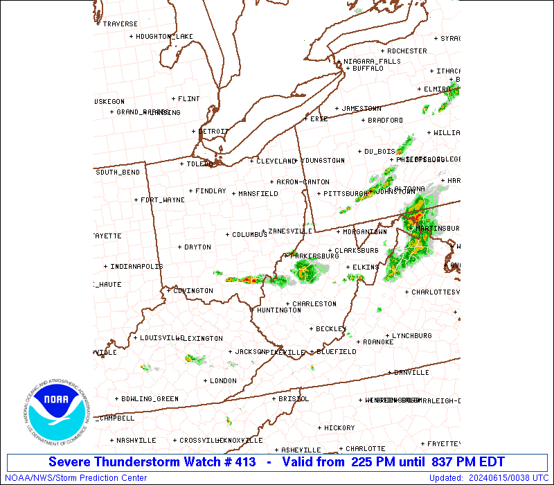
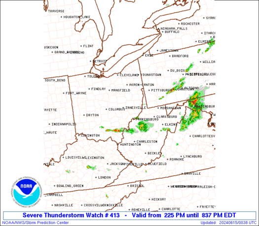
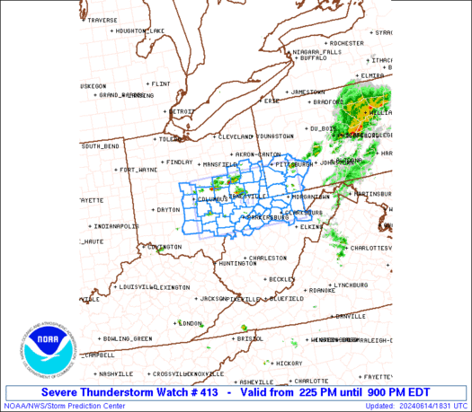
Severe Thunderstorm Watch Number 413
NWS Storm Prediction Center Norman OK
225 PM EDT Fri Jun 14 2024
The NWS Storm Prediction Center has issued a
* Severe Thunderstorm Watch for portions of
Central and Eastern Ohio
Southwest Pennsylvania
Northern West Virginia
* Effective this Friday afternoon and evening from 225 PM until
900 PM EDT.
* Primary threats include...
Scattered damaging wind gusts to 70 mph possible
Scattered large hail events to 1.5 inches in diameter possible
SUMMARY...Thunderstorms should continue to strengthen this afternoon
as they spread east-southeastward. The strongest thunderstorms may
be capable of producing large hail around 1-1.5 inches in diameter,
along with severe/damaging winds of 55-70 mph.
The severe thunderstorm watch area is approximately along and 50
statute miles north and south of a line from 50 miles northwest of
Athens OH to 25 miles east northeast of Morgantown WV. For a
complete depiction of the watch see the associated watch outline
update (WOUS64 KWNS WOU3).
PRECAUTIONARY/PREPAREDNESS ACTIONS...
REMEMBER...A Severe Thunderstorm Watch means conditions are
favorable for severe thunderstorms in and close to the watch area.
Persons in these areas should be on the lookout for threatening
weather conditions and listen for later statements and possible
warnings. Severe thunderstorms can and occasionally do produce
tornadoes.
&&
AVIATION...A few severe thunderstorms with hail surface and aloft to
1.5 inches. Extreme turbulence and surface wind gusts to 60 knots. A
few cumulonimbi with maximum tops to 500. Mean storm motion vector
30035.
...Gleason
SEL3
URGENT - IMMEDIATE BROADCAST REQUESTED
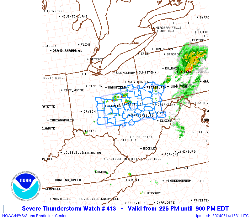
Severe Thunderstorm Watch Number 413
NWS Storm Prediction Center Norman OK
225 PM EDT Fri Jun 14 2024
The NWS Storm Prediction Center has issued a
* Severe Thunderstorm Watch for portions of
Central and Eastern Ohio
Southwest Pennsylvania
Northern West Virginia
* Effective this Friday afternoon and evening from 225 PM until
900 PM EDT.
* Primary threats include...
Scattered damaging wind gusts to 70 mph possible
Scattered large hail events to 1.5 inches in diameter possible
SUMMARY...Thunderstorms should continue to strengthen this afternoon
as they spread east-southeastward. The strongest thunderstorms may
be capable of producing large hail around 1-1.5 inches in diameter,
along with severe/damaging winds of 55-70 mph.
The severe thunderstorm watch area is approximately along and 50
statute miles north and south of a line from 50 miles northwest of
Athens OH to 25 miles east northeast of Morgantown WV. For a
complete depiction of the watch see the associated watch outline
update (WOUS64 KWNS WOU3).
PRECAUTIONARY/PREPAREDNESS ACTIONS...
REMEMBER...A Severe Thunderstorm Watch means conditions are
favorable for severe thunderstorms in and close to the watch area.
Persons in these areas should be on the lookout for threatening
weather conditions and listen for later statements and possible
warnings. Severe thunderstorms can and occasionally do produce
tornadoes.
&&
AVIATION...A few severe thunderstorms with hail surface and aloft to
1.5 inches. Extreme turbulence and surface wind gusts to 60 knots. A
few cumulonimbi with maximum tops to 500. Mean storm motion vector
30035.
...Gleason
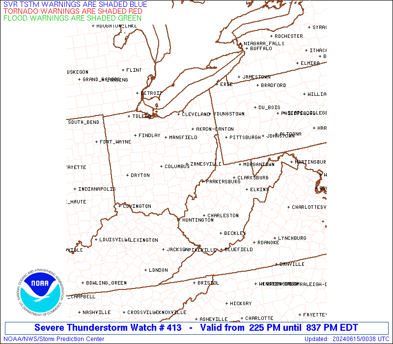
 Note:
The Aviation Watch (SAW) product is an approximation to the watch area.
The actual watch is depicted by the shaded areas.
Note:
The Aviation Watch (SAW) product is an approximation to the watch area.
The actual watch is depicted by the shaded areas.
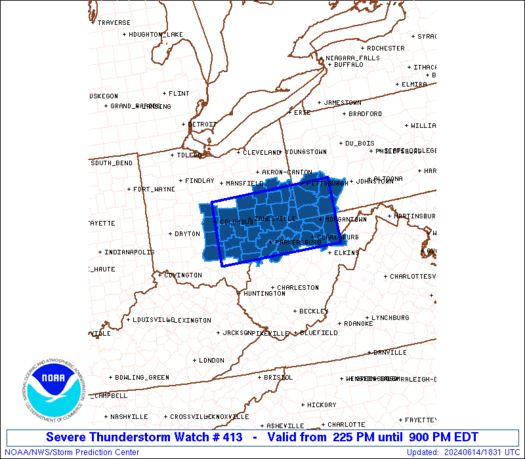
   SAW3
   WW 413 SEVERE TSTM OH PA WV 141825Z - 150100Z
   AXIS..50 STATUTE MILES NORTH AND SOUTH OF LINE..
   50NW UNI/ATHENS OH/ - 25ENE MGW/MORGANTOWN WV/
   ..AVIATION COORDS.. 45NM N/S /29SSW APE - 44SW JST/
   HAIL SURFACE AND ALOFT..1.5 INCHES. WIND GUSTS..60 KNOTS.
   MAX TOPS TO 500. MEAN STORM MOTION VECTOR 30035.

   LAT...LON 40458290 40507948 39067948 39008290

   THIS IS AN APPROXIMATION TO THE WATCH AREA.  FOR A
   COMPLETE DEPICTION OF THE WATCH SEE WOUS64 KWNS
   FOR WOU3.
Watch 413 Status Report Messages:
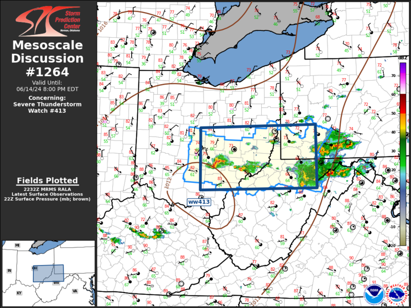
STATUS REPORT #1 ON WW 413

VALID 142245Z - 142340Z

SEVERE WEATHER THREAT CONTINUES RIGHT OF A LINE FROM 15 S CMH TO
30 NE EKN.

..SPC..06/14/24

ATTN...WFO...RLX...PBZ...ILN...

&&

STATUS REPORT FOR WS 413

SEVERE WEATHER THREAT CONTINUES FOR THE FOLLOWING AREAS

OHC009-045-073-105-115-127-129-141-163-167-142340-

OH
.    OHIO COUNTIES INCLUDED ARE

ATHENS		     FAIRFIELD		 HOCKING
MEIGS		     MORGAN		 PERRY
PICKAWAY	     ROSS		 VINTON
WASHINGTON
$$


WVC001-017-033-049-073-085-091-093-095-105-107-142340-

WV
.    WEST VIRGINIA COUNTIES INCLUDED ARE

BARBOUR 	     DODDRIDGE		 HARRISON
MARION		     PLEASANTS		 RITCHIE
TAYLOR		     TUCKER		 TYLER
WIRT		     WOOD
$$


THE WATCH STATUS MESSAGE IS FOR GUIDANCE PURPOSES ONLY.  PLEASE
REFER TO WATCH COUNTY NOTIFICATION STATEMENTS FOR OFFICIAL
INFORMATION ON COUNTIES...INDEPENDENT CITIES AND MARINE ZONES
CLEARED FROM SEVERE THUNDERSTORM AND TORNADO WATCHES.
$$
Note:
Click for Complete Product Text.
Tornadoes
Probability of 2 or more tornadoes
|
Low (<5%)
|
Probability of 1 or more strong (EF2-EF5) tornadoes
|
Low (<2%)
|
Wind
Probability of 10 or more severe wind events
|
Mod (40%)
|
Probability of 1 or more wind events > 65 knots
|
Low (20%)
|
Hail
Probability of 10 or more severe hail events
|
Mod (40%)
|
Probability of 1 or more hailstones > 2 inches
|
Low (20%)
|
Combined Severe Hail/Wind
Probability of 6 or more combined severe hail/wind events
|
High (70%)
|
For each watch, probabilities for particular events inside the watch
(listed above in each table) are determined by the issuing forecaster.
The "Low" category contains probability values ranging from less than 2%
to 20% (EF2-EF5 tornadoes), less than 5% to 20% (all other probabilities),
"Moderate" from 30% to 60%, and "High" from 70% to greater than 95%.
High values are bolded and lighter in color to provide awareness of
an increased threat for a particular event.


 @NWSSPC