 Note:
The expiration time in the watch graphic is amended if the watch is
replaced, cancelled or extended.
Note:
Note:
The expiration time in the watch graphic is amended if the watch is
replaced, cancelled or extended.
Note: Click for
Watch Status Reports.
SEL4
URGENT - IMMEDIATE BROADCAST REQUESTED
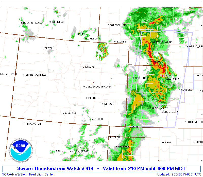
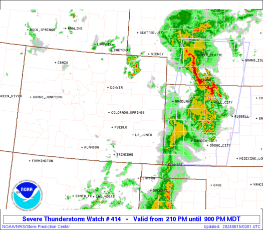
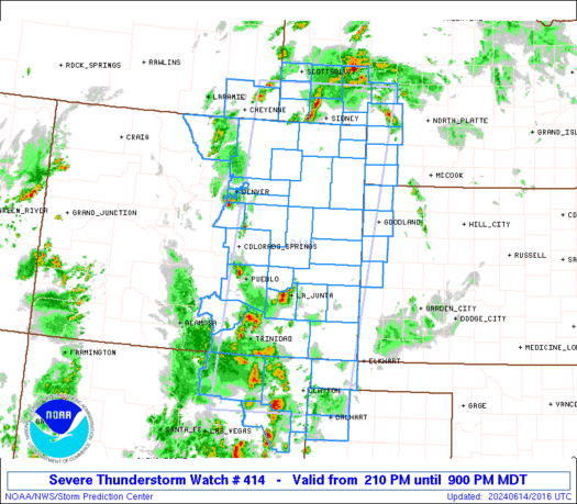
Severe Thunderstorm Watch Number 414
NWS Storm Prediction Center Norman OK
210 PM MDT Fri Jun 14 2024
The NWS Storm Prediction Center has issued a
* Severe Thunderstorm Watch for portions of
Eastern Colorado
Western Kansas
Western and Southwest Nebraska
Northeast New Mexico
The Far Western Oklahoma Panhandle
The Northwest Texas Panhandle
Far Southeast Wyoming
* Effective this Friday afternoon and evening from 210 PM until
900 PM MDT.
* Primary threats include...
Scattered damaging winds likely with isolated significant gusts
to 80 mph possible
Scattered large hail and isolated very large hail events to 2
inches in diameter possible
A tornado or two possible
SUMMARY...Thunderstorms will continue to develop and pose a threat
for large hail around 1-2 inches in diameter this afternoon. With
time, thunderstorms should consolidate into a bowing cluster moving
east-northeastward, with a greater threat for severe/damaging winds
around 60-80 mph.
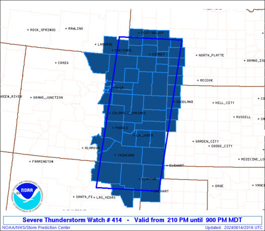
The severe thunderstorm watch area is approximately along and 80
statute miles east and west of a line from 40 miles southwest of
Clayton NM to 40 miles north of Sidney NE. For a complete depiction
of the watch see the associated watch outline update (WOUS64 KWNS
WOU4).
PRECAUTIONARY/PREPAREDNESS ACTIONS...
REMEMBER...A Severe Thunderstorm Watch means conditions are
favorable for severe thunderstorms in and close to the watch area.
Persons in these areas should be on the lookout for threatening
weather conditions and listen for later statements and possible
warnings. Severe thunderstorms can and occasionally do produce
tornadoes.
&&
OTHER WATCH INFORMATION...CONTINUE...WW 413...
AVIATION...A few severe thunderstorms with hail surface and aloft to
2 inches. Extreme turbulence and surface wind gusts to 70 knots. A
few cumulonimbi with maximum tops to 550. Mean storm motion vector
22035.
...Gleason
   SEL4

   URGENT - IMMEDIATE BROADCAST REQUESTED
   Severe Thunderstorm Watch Number 414
   NWS Storm Prediction Center Norman OK
   210 PM MDT Fri Jun 14 2024

   The NWS Storm Prediction Center has issued a

   * Severe Thunderstorm Watch for portions of
     Eastern Colorado
     Western Kansas
     Western and Southwest Nebraska
     Northeast New Mexico
     The Far Western Oklahoma Panhandle
     The Northwest Texas Panhandle
     Far Southeast Wyoming

   * Effective this Friday afternoon and evening from 210 PM until
     900 PM MDT.

   * Primary threats include...
     Scattered damaging winds likely with isolated significant gusts
       to 80 mph possible
     Scattered large hail and isolated very large hail events to 2
       inches in diameter possible
     A tornado or two possible

   SUMMARY...Thunderstorms will continue to develop and pose a threat
   for large hail around 1-2 inches in diameter this afternoon. With
   time, thunderstorms should consolidate into a bowing cluster moving
   east-northeastward, with a greater threat for severe/damaging winds
   around 60-80 mph.

   The severe thunderstorm watch area is approximately along and 80
   statute miles east and west of a line from 40 miles southwest of
   Clayton NM to 40 miles north of Sidney NE. For a complete depiction
   of the watch see the associated watch outline update (WOUS64 KWNS
   WOU4).

   PRECAUTIONARY/PREPAREDNESS ACTIONS...

   REMEMBER...A Severe Thunderstorm Watch means conditions are
   favorable for severe thunderstorms in and close to the watch area.
   Persons in these areas should be on the lookout for threatening
   weather conditions and listen for later statements and possible
   warnings. Severe thunderstorms can and occasionally do produce
   tornadoes.

   &&

   OTHER WATCH INFORMATION...CONTINUE...WW 413...

   AVIATION...A few severe thunderstorms with hail surface and aloft to
   2 inches. Extreme turbulence and surface wind gusts to 70 knots. A
   few cumulonimbi with maximum tops to 550. Mean storm motion vector
   22035.

   ...Gleason
 Note:
The Aviation Watch (SAW) product is an approximation to the watch area.
The actual watch is depicted by the shaded areas.
Note:
The Aviation Watch (SAW) product is an approximation to the watch area.
The actual watch is depicted by the shaded areas.
   SAW4
   WW 414 SEVERE TSTM CO KS NE NM OK TX WY 142010Z - 150300Z
   AXIS..80 STATUTE MILES EAST AND WEST OF LINE..
   40SW CAO/CLAYTON NM/ - 40N SNY/SIDNEY NE/
   ..AVIATION COORDS.. 70NM E/W /52N TCC - 26ESE BFF/
   HAIL SURFACE AND ALOFT..2 INCHES. WIND GUSTS..70 KNOTS.
   MAX TOPS TO 550. MEAN STORM MOTION VECTOR 22035.

   LAT...LON 36030509 41670453 41670143 36030222

   THIS IS AN APPROXIMATION TO THE WATCH AREA.  FOR A
   COMPLETE DEPICTION OF THE WATCH SEE WOUS64 KWNS
   FOR WOU4.
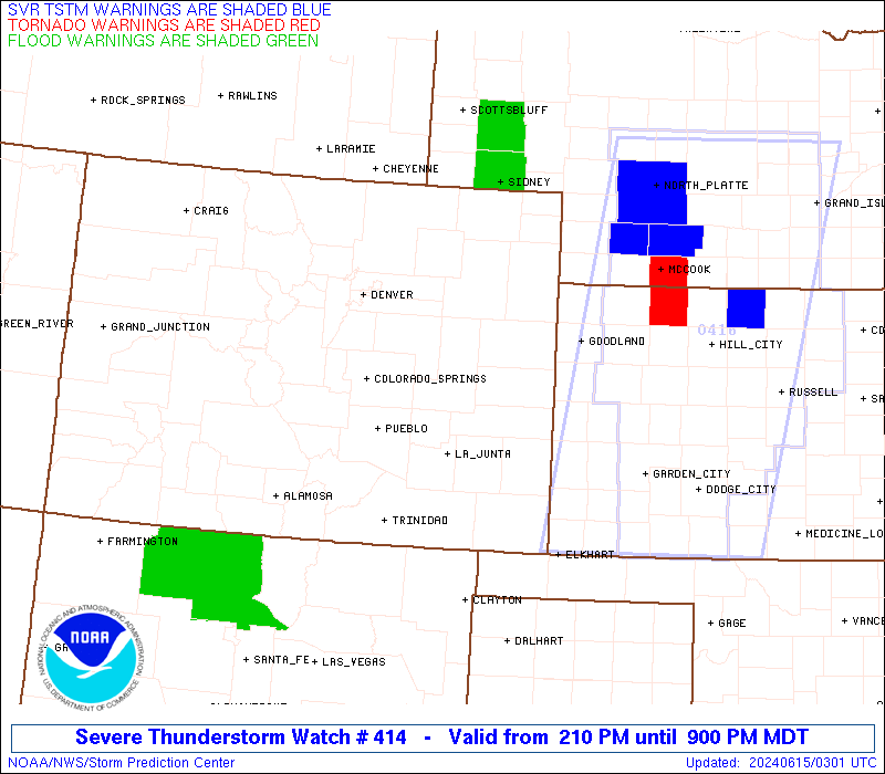
Watch 414 Status Report Messages:
STATUS REPORT #3 ON WW 414

VALID 150150Z - 150240Z

SEVERE WEATHER THREAT CONTINUES RIGHT OF A LINE FROM 25 ESE GLD
TO 15 ESE AIA.

..THORNTON..06/15/24

ATTN...WFO...BOU...PUB...GLD...LBF...CYS...ABQ...AMA...

&&

STATUS REPORT FOR WS 414

SEVERE WEATHER THREAT CONTINUES FOR THE FOLLOWING AREAS

NEC005-029-069-101-135-150240-

NE
.    NEBRASKA COUNTIES INCLUDED ARE

ARTHUR		     CHASE		 GARDEN
KEITH		     PERKINS
$$


THE WATCH STATUS MESSAGE IS FOR GUIDANCE PURPOSES ONLY.  PLEASE
REFER TO WATCH COUNTY NOTIFICATION STATEMENTS FOR OFFICIAL
INFORMATION ON COUNTIES...INDEPENDENT CITIES AND MARINE ZONES
CLEARED FROM SEVERE THUNDERSTORM AND TORNADO WATCHES.
$$

STATUS REPORT #2 ON WW 414

VALID 150100Z - 150240Z

SEVERE WEATHER THREAT CONTINUES RIGHT OF A LINE FROM 30 NNE TCC
TO 40 N EHA TO AIA.

..THORNTON..06/15/24

ATTN...WFO...BOU...PUB...GLD...LBF...CYS...ABQ...AMA...

&&

STATUS REPORT FOR WS 414

SEVERE WEATHER THREAT CONTINUES FOR THE FOLLOWING AREAS

COC095-115-125-150240-

CO
.    COLORADO COUNTIES INCLUDED ARE

PHILLIPS	     SEDGWICK		 YUMA
$$


KSC023-071-181-199-150240-

KS
.    KANSAS COUNTIES INCLUDED ARE

CHEYENNE	     GREELEY		 SHERMAN
WALLACE
$$


NEC005-029-049-057-069-101-135-150240-

NE
.    NEBRASKA COUNTIES INCLUDED ARE

ARTHUR		     CHASE		 DEUEL
DUNDY		     GARDEN		 KEITH
PERKINS
$$


OKC025-139-150240-

OK
.    OKLAHOMA COUNTIES INCLUDED ARE

CIMARRON	     TEXAS
$$


TXC111-205-150240-

TX
.    TEXAS COUNTIES INCLUDED ARE

DALLAM		     HARTLEY
$$


THE WATCH STATUS MESSAGE IS FOR GUIDANCE PURPOSES ONLY.  PLEASE
REFER TO WATCH COUNTY NOTIFICATION STATEMENTS FOR OFFICIAL
INFORMATION ON COUNTIES...INDEPENDENT CITIES AND MARINE ZONES
CLEARED FROM SEVERE THUNDERSTORM AND TORNADO WATCHES.
$$

STATUS REPORT #1 ON WW 414

VALID 142335Z - 150040Z

SEVERE WEATHER THREAT CONTINUES RIGHT OF A LINE FROM 50 ENE LVS
TO 15 SW LAA TO 20 SSE TOR.

..THORNTON..06/14/24

ATTN...WFO...BOU...PUB...GLD...LBF...CYS...ABQ...AMA...

&&

STATUS REPORT FOR WS 414

SEVERE WEATHER THREAT CONTINUES FOR THE FOLLOWING AREAS

COC009-017-061-063-075-095-099-115-121-125-150040-

CO
.    COLORADO COUNTIES INCLUDED ARE

BACA		     CHEYENNE		 KIOWA
KIT CARSON	     LOGAN		 PHILLIPS
PROWERS 	     SEDGWICK		 WASHINGTON
YUMA
$$


KSC023-071-181-199-150040-

KS
.    KANSAS COUNTIES INCLUDED ARE

CHEYENNE	     GREELEY		 SHERMAN
WALLACE
$$


NEC005-007-029-033-049-057-069-101-105-123-135-157-150040-

NE
.    NEBRASKA COUNTIES INCLUDED ARE

ARTHUR		     BANNER		 CHASE
CHEYENNE	     DEUEL		 DUNDY
GARDEN		     KEITH		 KIMBALL
MORRILL 	     PERKINS		 SCOTTS BLUFF
$$


NMC021-059-150040-

NM
.    NEW MEXICO COUNTIES INCLUDED ARE

HARDING 	     UNION
$$


OKC025-150040-

OK
.    OKLAHOMA COUNTIES INCLUDED ARE

CIMARRON
$$


TXC111-205-150040-

TX
.    TEXAS COUNTIES INCLUDED ARE

DALLAM		     HARTLEY
$$


THE WATCH STATUS MESSAGE IS FOR GUIDANCE PURPOSES ONLY.  PLEASE
REFER TO WATCH COUNTY NOTIFICATION STATEMENTS FOR OFFICIAL
INFORMATION ON COUNTIES...INDEPENDENT CITIES AND MARINE ZONES
CLEARED FROM SEVERE THUNDERSTORM AND TORNADO WATCHES.
$$
Note:
Click for Complete Product Text.
Tornadoes
Probability of 2 or more tornadoes
|
Low (20%)
|
Probability of 1 or more strong (EF2-EF5) tornadoes
|
Low (10%)
|
Wind
Probability of 10 or more severe wind events
|
High (70%)
|
Probability of 1 or more wind events > 65 knots
|
Mod (50%)
|
Hail
Probability of 10 or more severe hail events
|
Mod (40%)
|
Probability of 1 or more hailstones > 2 inches
|
Mod (30%)
|
Combined Severe Hail/Wind
Probability of 6 or more combined severe hail/wind events
|
High (80%)
|
For each watch, probabilities for particular events inside the watch
(listed above in each table) are determined by the issuing forecaster.
The "Low" category contains probability values ranging from less than 2%
to 20% (EF2-EF5 tornadoes), less than 5% to 20% (all other probabilities),
"Moderate" from 30% to 60%, and "High" from 70% to greater than 95%.
High values are bolded and lighter in color to provide awareness of
an increased threat for a particular event.


 @NWSSPC