 Note:
The expiration time in the watch graphic is amended if the watch is
replaced, cancelled or extended.
Note:
Note:
The expiration time in the watch graphic is amended if the watch is
replaced, cancelled or extended.
Note: Click for
Watch Status Reports.
SEL5
URGENT - IMMEDIATE BROADCAST REQUESTED
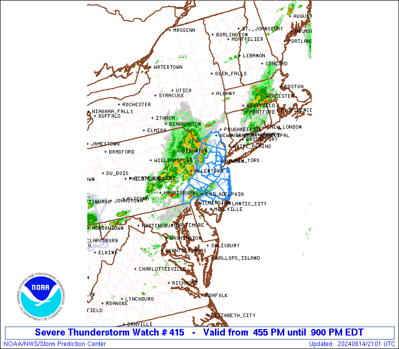
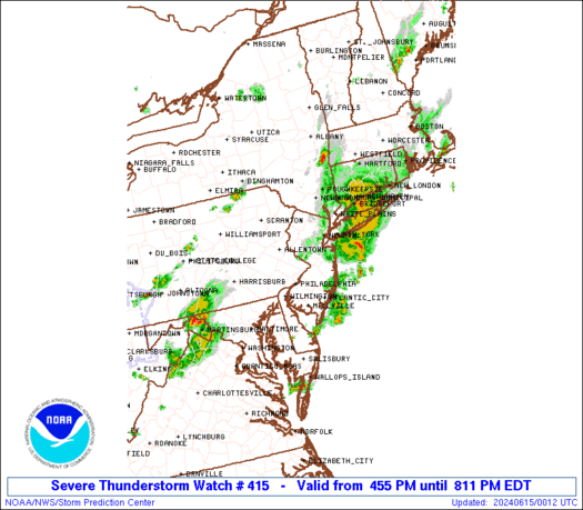
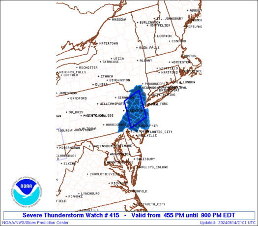
Severe Thunderstorm Watch Number 415
NWS Storm Prediction Center Norman OK
455 PM EDT Fri Jun 14 2024
The NWS Storm Prediction Center has issued a
* Severe Thunderstorm Watch for portions of
New Jersey
Southern New York
Far Eastern Pennsylvania
* Effective this Friday afternoon and evening from 455 PM until
900 PM EDT.
* Primary threats include...
Scattered damaging wind gusts to 70 mph possible
Isolated large hail events to 1 inch in diameter possible
SUMMARY...Loosely organized thunderstorm clusters should continue to
pose a threat for mainly damaging winds around 50-70 mph as they
spread eastward over the next few hours.
The severe thunderstorm watch area is approximately along and 45
statute miles north and south of a line from 25 miles west northwest
of Trenton NJ to 45 miles northeast of Trenton NJ. For a complete
depiction of the watch see the associated watch outline update
(WOUS64 KWNS WOU5).
PRECAUTIONARY/PREPAREDNESS ACTIONS...
REMEMBER...A Severe Thunderstorm Watch means conditions are
favorable for severe thunderstorms in and close to the watch area.
Persons in these areas should be on the lookout for threatening
weather conditions and listen for later statements and possible
warnings. Severe thunderstorms can and occasionally do produce
tornadoes.
&&
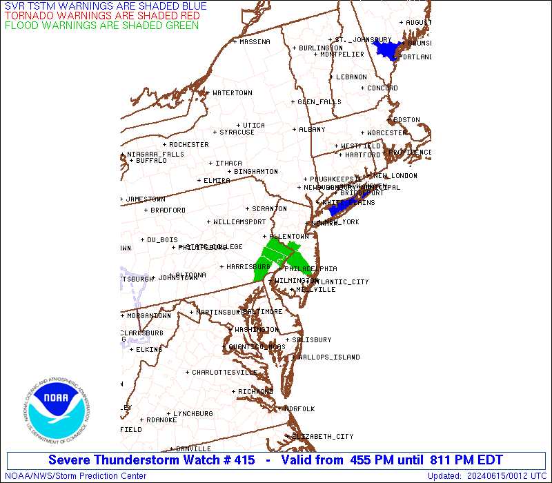
OTHER WATCH INFORMATION...CONTINUE...WW 413...WW 414...
AVIATION...A few severe thunderstorms with hail surface and aloft to
1 inch. Extreme turbulence and surface wind gusts to 60 knots. A few
cumulonimbi with maximum tops to 500. Mean storm motion vector
27035.
...Gleason
 Note:
The Aviation Watch (SAW) product is an approximation to the watch area.
The actual watch is depicted by the shaded areas.
Note:
The Aviation Watch (SAW) product is an approximation to the watch area.
The actual watch is depicted by the shaded areas.
   SAW5
   WW 415 SEVERE TSTM NJ NY PA 142055Z - 150100Z
   AXIS..45 STATUTE MILES NORTH AND SOUTH OF LINE..
   25WNW TTN/TRENTON NJ/ - 45NE TTN/TRENTON NJ/
   ..AVIATION COORDS.. 40NM N/S /22ESE ETX - 21WNW JFK/
   HAIL SURFACE AND ALOFT..1 INCH. WIND GUSTS..60 KNOTS.
   MAX TOPS TO 500. MEAN STORM MOTION VECTOR 27035.

   LAT...LON 41077525 41397419 40097419 39777525

   THIS IS AN APPROXIMATION TO THE WATCH AREA.  FOR A
   COMPLETE DEPICTION OF THE WATCH SEE WOUS64 KWNS
   FOR WOU5.
Watch 415 Status Report Messages:
STATUS REPORT #1 ON WW 415

VALID 142240Z - 142340Z

SEVERE WEATHER THREAT CONTINUES RIGHT OF A LINE FROM 20 E PHL TO
10 N EWR.

..SPC..06/14/24

ATTN...WFO...OKX...PHI...

&&

STATUS REPORT FOR WS 415

SEVERE WEATHER THREAT CONTINUES FOR THE FOLLOWING AREAS

NJC003-005-007-013-015-017-023-025-029-035-039-142340-

NJ
.    NEW JERSEY COUNTIES INCLUDED ARE

BERGEN		     BURLINGTON 	 CAMDEN
ESSEX		     GLOUCESTER 	 HUDSON
MIDDLESEX	     MONMOUTH		 OCEAN
SOMERSET	     UNION
$$


NYC087-142340-

NY
.    NEW YORK COUNTIES INCLUDED ARE

ROCKLAND
$$


THE WATCH STATUS MESSAGE IS FOR GUIDANCE PURPOSES ONLY.  PLEASE
REFER TO WATCH COUNTY NOTIFICATION STATEMENTS FOR OFFICIAL
INFORMATION ON COUNTIES...INDEPENDENT CITIES AND MARINE ZONES
CLEARED FROM SEVERE THUNDERSTORM AND TORNADO WATCHES.
$$
Note:
Click for Complete Product Text.
Tornadoes
Probability of 2 or more tornadoes
|
Low (<5%)
|
Probability of 1 or more strong (EF2-EF5) tornadoes
|
Low (<2%)
|
Wind
Probability of 10 or more severe wind events
|
Mod (40%)
|
Probability of 1 or more wind events > 65 knots
|
Low (20%)
|
Hail
Probability of 10 or more severe hail events
|
Low (20%)
|
Probability of 1 or more hailstones > 2 inches
|
Low (10%)
|
Combined Severe Hail/Wind
Probability of 6 or more combined severe hail/wind events
|
Mod (50%)
|
For each watch, probabilities for particular events inside the watch
(listed above in each table) are determined by the issuing forecaster.
The "Low" category contains probability values ranging from less than 2%
to 20% (EF2-EF5 tornadoes), less than 5% to 20% (all other probabilities),
"Moderate" from 30% to 60%, and "High" from 70% to greater than 95%.
High values are bolded and lighter in color to provide awareness of
an increased threat for a particular event.


 @NWSSPC