|
| Mesoscale Discussion 1263 |
|
< Previous MD Next MD >
|
|
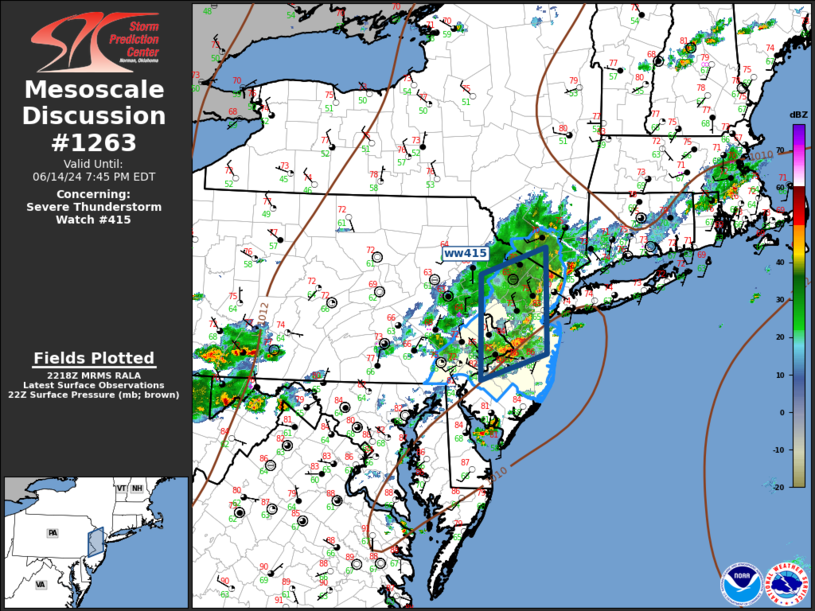
   Mesoscale Discussion 1263
   NWS Storm Prediction Center Norman OK
   0520 PM CDT Fri Jun 14 2024

   Areas affected...Middle Atlantic

   Concerning...Severe Thunderstorm Watch 415...

   Valid 142220Z - 142345Z

   The severe weather threat for Severe Thunderstorm Watch 415
   continues.

   SUMMARY...Locally damaging winds and marginally severe hail are
   expected with convection early this evening.

   DISCUSSION...Weak mid-level short-wave trough is ejecting across the
   Middle Atlantic early this evening. This feature appears to be
   aiding a broad corridor of convection that extends from the lower
   Hudson Valley, arcing southwest across central NJ where convection
   has recently intensified, possibly due to coastal boundary
   interactions. Surface temperatures are seasonally warm ahead of this
   activity, even near the coast where readings remain in the 80s.
   Modest buoyancy extends across the Delmarva into southern New
   England and this will contribute to new updrafts forming along the
   leading outflow as the aforementioned complex advances east this
   evening. Locally damaging winds are the primary risk along with
   marginally severe hail.

   ..Darrow.. 06/14/2024

   ...Please see www.spc.noaa.gov for graphic product...

   ATTN...WFO...OKX...PHI...BGM...

   LAT...LON   39767524 41067523 41397419 40087418 39767524
|
|
Top/All Mesoscale Discussions/Forecast Products/Home
|
|


 @NWSSPC