Note:
The expiration time in the watch graphic is amended if the watch is
replaced, cancelled or extended.
Note:
Note:
The expiration time in the watch graphic is amended if the watch is
replaced, cancelled or extended.
Note: Click for
Watch Status Reports.
SEL2
URGENT - IMMEDIATE BROADCAST REQUESTED
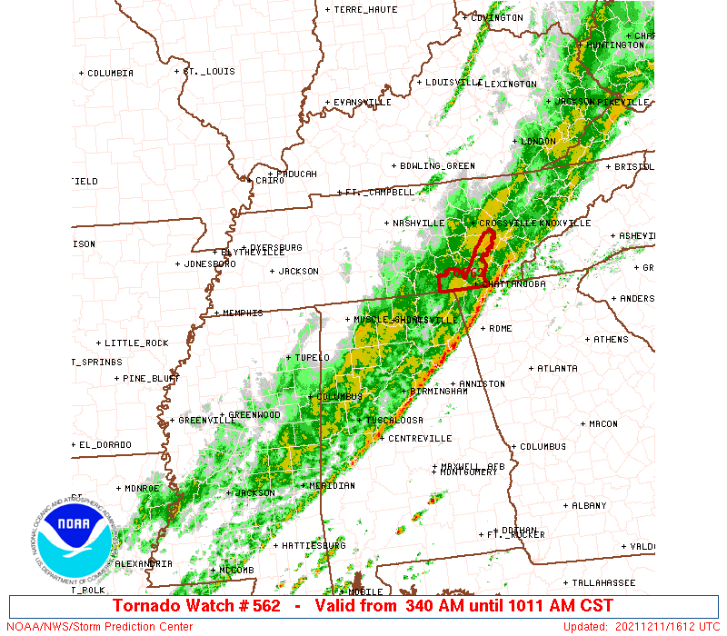
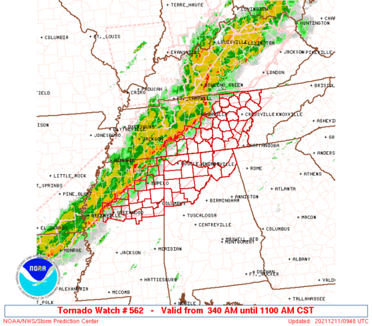
Tornado Watch Number 562
NWS Storm Prediction Center Norman OK
340 AM CST Sat Dec 11 2021
The NWS Storm Prediction Center has issued a
* Tornado Watch for portions of
Northern Alabama
North-central and northeastern Mississippi
Middle and eastern Tennessee
* Effective this Saturday morning from 340 AM until 1100 AM CST.
* Primary threats include...
A few tornadoes and a couple intense tornadoes possible
Scattered damaging winds and isolated significant gusts to 75
mph possible
SUMMARY...A belt of strong-severe thunderstorms, with embedded QLCS
mesovortices and bows, as well as isolated supercells in and ahead
of the line, should move through the watch area through the
remainder of the morning. This activity poses a threat for severe
gusts, a few tornadoes, and isolated large hail.
The tornado watch area is approximately along and 45 statute miles
east and west of a line from 50 miles west southwest of Columbus MS
to 165 miles northeast of Huntsville AL. For a complete depiction of
the watch see the associated watch outline update (WOUS64 KWNS
WOU2).
PRECAUTIONARY/PREPAREDNESS ACTIONS...
REMEMBER...A Tornado Watch means conditions are favorable for
tornadoes and severe thunderstorms in and close to the watch
area. Persons in these areas should be on the lookout for
threatening weather conditions and listen for later statements
and possible warnings.
&&
OTHER WATCH INFORMATION...CONTINUE...WW 558...WW 559...WW
560...WW 561...
AVIATION...Tornadoes and a few severe thunderstorms with hail
surface and aloft to 1.5 inches. Extreme turbulence and surface wind
gusts to 65 knots. A few cumulonimbi with maximum tops to 500. Mean
storm motion vector 24040.
...Edwards
   SEL2

   URGENT - IMMEDIATE BROADCAST REQUESTED
   Tornado Watch Number 562
   NWS Storm Prediction Center Norman OK
   340 AM CST Sat Dec 11 2021

   The NWS Storm Prediction Center has issued a

   * Tornado Watch for portions of
     Northern Alabama
     North-central and northeastern Mississippi
     Middle and eastern Tennessee

   * Effective this Saturday morning from 340 AM until 1100 AM CST.

   * Primary threats include...
     A few tornadoes and a couple intense tornadoes possible
     Scattered damaging winds and isolated significant gusts to 75
       mph possible

   SUMMARY...A belt of strong-severe thunderstorms, with embedded QLCS
   mesovortices and bows, as well as isolated supercells in and ahead
   of the line, should move through the watch area through the
   remainder of the morning.  This activity poses a threat for severe
   gusts, a few tornadoes, and isolated large hail.

   The tornado watch area is approximately along and 45 statute miles
   east and west of a line from 50 miles west southwest of Columbus MS
   to 165 miles northeast of Huntsville AL. For a complete depiction of
   the watch see the associated watch outline update (WOUS64 KWNS
   WOU2).

   PRECAUTIONARY/PREPAREDNESS ACTIONS...

   REMEMBER...A Tornado Watch means conditions are favorable for
   tornadoes and severe thunderstorms in and close to the watch
   area. Persons in these areas should be on the lookout for
   threatening weather conditions and listen for later statements
   and possible warnings.

   &&

   OTHER WATCH INFORMATION...CONTINUE...WW 558...WW 559...WW
   560...WW 561...

   AVIATION...Tornadoes and a few severe thunderstorms with hail
   surface and aloft to 1.5 inches. Extreme turbulence and surface wind
   gusts to 65 knots. A few cumulonimbi with maximum tops to 500. Mean
   storm motion vector 24040.

   ...Edwards
 Note:
The Aviation Watch (SAW) product is an approximation to the watch area.
The actual watch is depicted by the shaded areas.
Note:
The Aviation Watch (SAW) product is an approximation to the watch area.
The actual watch is depicted by the shaded areas.
SAW2
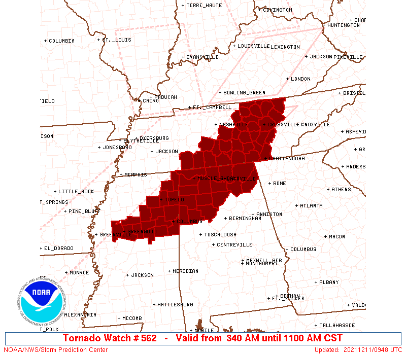
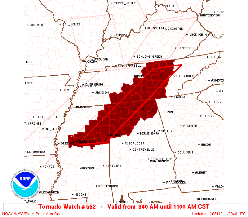
WW 562 TORNADO AL MS TN 110940Z - 111700Z
AXIS..45 STATUTE MILES EAST AND WEST OF LINE..
50WSW CBM/COLUMBUS MS/ - 165NE HSV/HUNTSVILLE AL/
..AVIATION COORDS.. 40NM E/W /37WSW IGB - 46WNW VXV/
HAIL SURFACE AND ALOFT..1.5 INCHES. WIND GUSTS..65 KNOTS.
MAX TOPS TO 500. MEAN STORM MOTION VECTOR 24040.
LAT...LON 33349003 36328549 36328388 33348847
THIS IS AN APPROXIMATION TO THE WATCH AREA. FOR A
COMPLETE DEPICTION OF THE WATCH SEE WOUS64 KWNS
FOR WOU2.
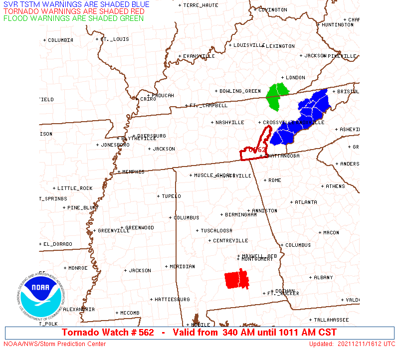
Watch 562 Status Report Messages:
STATUS REPORT #3 ON WW 562

VALID 111235Z - 111340Z

SEVERE WEATHER THREAT CONTINUES RIGHT OF A LINE FROM 50 WSW CBM
TO 30 W CBM TO 40 NNE CBM TO 20 NNW HSV TO 45 N HSV TO 45 ESE BNA
TO 25 WNW CSV TO 40 SW LOZ.

FOR ADDITIONAL INFORMATION SEE MESOSCALE DISCUSSION 2019

..LEITMAN..12/11/21

ATTN...WFO...HUN...BMX...MEG...JAN...OHX...MRX...

&&

STATUS REPORT FOR WT 562

SEVERE WEATHER THREAT CONTINUES FOR THE FOLLOWING AREAS

ALC043-049-057-071-075-079-083-089-093-095-103-127-133-111340-

AL
.    ALABAMA COUNTIES INCLUDED ARE

CULLMAN 	     DEKALB		 FAYETTE
JACKSON 	     LAMAR		 LAWRENCE
LIMESTONE	     MADISON		 MARION
MARSHALL	     MORGAN		 WALKER
WINSTON
$$


MSC025-087-095-105-111340-

MS
.    MISSISSIPPI COUNTIES INCLUDED ARE

CLAY		     LOWNDES		 MONROE
OKTIBBEHA
$$


TNC003-007-031-035-041-049-051-061-065-103-115-127-129-133-143-
151-153-175-177-185-111340-

TN
.    TENNESSEE COUNTIES INCLUDED ARE

BEDFORD 	     BLEDSOE		 COFFEE
CUMBERLAND	     DE KALB		 FENTRESS
FRANKLIN	     GRUNDY		 HAMILTON
LINCOLN 	     MARION		 MOORE
MORGAN		     OVERTON		 RHEA
SCOTT		     SEQUATCHIE 	 VAN BUREN
WARREN		     WHITE
$$


THE WATCH STATUS MESSAGE IS FOR GUIDANCE PURPOSES ONLY.  PLEASE
REFER TO WATCH COUNTY NOTIFICATION STATEMENTS FOR OFFICIAL
INFORMATION ON COUNTIES...INDEPENDENT CITIES AND MARINE ZONES
CLEARED FROM SEVERE THUNDERSTORM AND TORNADO WATCHES.
$$

STATUS REPORT #2 ON WW 562

VALID 111140Z - 111240Z

SEVERE WEATHER THREAT CONTINUES RIGHT OF A LINE FROM 25 SSE GWO
TO 30 SSW TUP TO 30 ENE TUP TO 35 NNE MSL TO 35 S BNA TO 20 S BNA.

..LEITMAN..12/11/21

ATTN...WFO...HUN...BMX...MEG...JAN...OHX...MRX...

&&

STATUS REPORT FOR WT 562

SEVERE WEATHER THREAT CONTINUES FOR THE FOLLOWING AREAS

ALC033-043-049-057-059-071-075-077-079-083-089-093-095-103-127-
133-111240-

AL
.    ALABAMA COUNTIES INCLUDED ARE

COLBERT 	     CULLMAN		 DEKALB
FAYETTE 	     FRANKLIN		 JACKSON
LAMAR		     LAUDERDALE 	 LAWRENCE
LIMESTONE	     MADISON		 MARION
MARSHALL	     MORGAN		 WALKER
WINSTON
$$


MSC017-019-025-057-087-095-097-105-155-111240-

MS
.    MISSISSIPPI COUNTIES INCLUDED ARE

CHICKASAW	     CHOCTAW		 CLAY
ITAWAMBA	     LOWNDES		 MONROE
MONTGOMERY	     OKTIBBEHA		 WEBSTER
$$


TNC003-007-015-027-031-035-041-049-051-055-061-065-087-103-115-
117-127-129-133-137-141-143-149-151-153-159-175-177-185-
111240-

TN
.    TENNESSEE COUNTIES INCLUDED ARE

BEDFORD 	     BLEDSOE		 CANNON
CLAY		     COFFEE		 CUMBERLAND
DE KALB 	     FENTRESS		 FRANKLIN
GILES		     GRUNDY		 HAMILTON
JACKSON 	     LINCOLN		 MARION
MARSHALL	     MOORE		 MORGAN
OVERTON 	     PICKETT		 PUTNAM
RHEA		     RUTHERFORD 	 SCOTT
SEQUATCHIE	     SMITH		 VAN BUREN
WARREN		     WHITE
$$


THE WATCH STATUS MESSAGE IS FOR GUIDANCE PURPOSES ONLY.  PLEASE
REFER TO WATCH COUNTY NOTIFICATION STATEMENTS FOR OFFICIAL
INFORMATION ON COUNTIES...INDEPENDENT CITIES AND MARINE ZONES
CLEARED FROM SEVERE THUNDERSTORM AND TORNADO WATCHES.
$$

STATUS REPORT #1 ON WW 562

VALID 111050Z - 111140Z

THE SEVERE WEATHER THREAT CONTINUES ACROSS THE ENTIRE WATCH AREA.

..LEITMAN..12/11/21

ATTN...WFO...HUN...BMX...MEG...JAN...OHX...MRX...

&&

STATUS REPORT FOR WT 562

SEVERE WEATHER THREAT CONTINUES FOR THE FOLLOWING AREAS

ALC033-043-049-057-059-071-075-077-079-083-089-093-095-103-127-
133-111140-

AL
.    ALABAMA COUNTIES INCLUDED ARE

COLBERT 	     CULLMAN		 DEKALB
FAYETTE 	     FRANKLIN		 JACKSON
LAMAR		     LAUDERDALE 	 LAWRENCE
LIMESTONE	     MADISON		 MARION
MARSHALL	     MORGAN		 WALKER
WINSTON
$$


MSC013-015-017-019-025-043-057-081-083-087-095-097-105-115-117-
141-155-111140-

MS
.    MISSISSIPPI COUNTIES INCLUDED ARE

CALHOUN 	     CARROLL		 CHICKASAW
CHOCTAW 	     CLAY		 GRENADA
ITAWAMBA	     LEE		 LEFLORE
LOWNDES 	     MONROE		 MONTGOMERY
OKTIBBEHA	     PONTOTOC		 PRENTISS
TISHOMINGO	     WEBSTER
$$


TNC003-007-015-027-031-035-041-049-051-055-061-065-087-099-103-
115-117-119-127-129-133-137-141-143-149-151-153-159-175-177-181-
185-111140-

TN
.    TENNESSEE COUNTIES INCLUDED ARE

BEDFORD 	     BLEDSOE		 CANNON
CLAY		     COFFEE		 CUMBERLAND
DE KALB 	     FENTRESS		 FRANKLIN
GILES		     GRUNDY		 HAMILTON
JACKSON 	     LAWRENCE		 LINCOLN
MARION		     MARSHALL		 MAURY
MOORE		     MORGAN		 OVERTON
PICKETT 	     PUTNAM		 RHEA
RUTHERFORD	     SCOTT		 SEQUATCHIE
SMITH		     VAN BUREN		 WARREN
WAYNE		     WHITE
$$


THE WATCH STATUS MESSAGE IS FOR GUIDANCE PURPOSES ONLY.  PLEASE
REFER TO WATCH COUNTY NOTIFICATION STATEMENTS FOR OFFICIAL
INFORMATION ON COUNTIES...INDEPENDENT CITIES AND MARINE ZONES
CLEARED FROM SEVERE THUNDERSTORM AND TORNADO WATCHES.
$$
Note:
Click for Complete Product Text.
Tornadoes
Probability of 2 or more tornadoes
|
Mod (50%)
|
Probability of 1 or more strong (EF2-EF5) tornadoes
|
Mod (30%)
|
Wind
Probability of 10 or more severe wind events
|
Mod (40%)
|
Probability of 1 or more wind events > 65 knots
|
Mod (30%)
|
Hail
Probability of 10 or more severe hail events
|
Low (10%)
|
Probability of 1 or more hailstones > 2 inches
|
Low (<5%)
|
Combined Severe Hail/Wind
Probability of 6 or more combined severe hail/wind events
|
High (70%)
|
For each watch, probabilities for particular events inside the watch
(listed above in each table) are determined by the issuing forecaster.
The "Low" category contains probability values ranging from less than 2%
to 20% (EF2-EF5 tornadoes), less than 5% to 20% (all other probabilities),
"Moderate" from 30% to 60%, and "High" from 70% to greater than 95%.
High values are bolded and lighter in color to provide awareness of
an increased threat for a particular event.


 @NWSSPC