 Note:
The expiration time in the watch graphic is amended if the watch is
replaced, cancelled or extended.
Note:
Note:
The expiration time in the watch graphic is amended if the watch is
replaced, cancelled or extended.
Note: Click for
Watch Status Reports.
SEL1
URGENT - IMMEDIATE BROADCAST REQUESTED
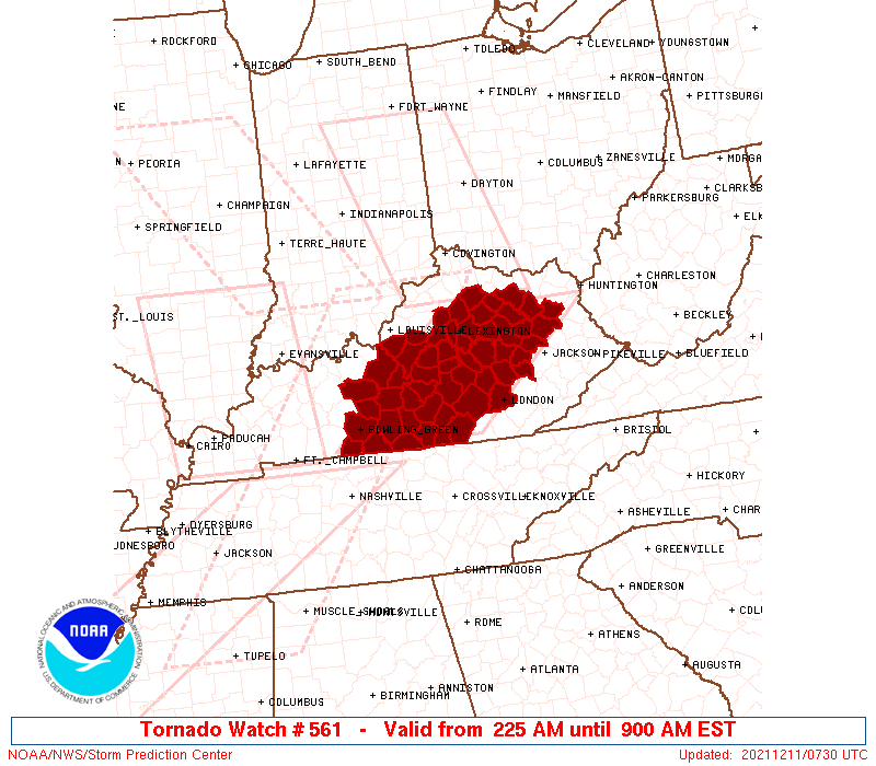
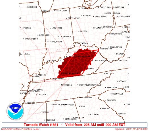
Tornado Watch Number 561
NWS Storm Prediction Center Norman OK
225 AM EST Sat Dec 11 2021
The NWS Storm Prediction Center has issued a
* Tornado Watch for portions of
Central and eastern Kentucky
* Effective this Saturday morning from 225 AM until 900 AM EST.
* Primary threats include...
A few tornadoes likely with a couple intense tornadoes possible
Scattered damaging winds likely with isolated significant gusts
to 75 mph possible
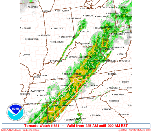
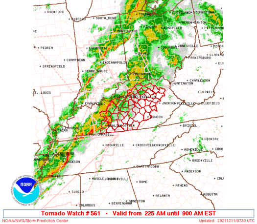
SUMMARY...A belt of strong-severe thunderstorms, including at least
a couple intense supercells with potential for significant/damaging
tornadoes, will affect the watch area past daybreak. The
overlapping counties affected replace part of tornado watch 554.
The tornado watch area is approximately along and 65 statute miles
east and west of a line from 45 miles east southeast of Bowling
Green KY to 50 miles east northeast of Lexington KY. For a complete
depiction of the watch see the associated watch outline update
(WOUS64 KWNS WOU1).
PRECAUTIONARY/PREPAREDNESS ACTIONS...
REMEMBER...A Tornado Watch means conditions are favorable for
tornadoes and severe thunderstorms in and close to the watch
area. Persons in these areas should be on the lookout for
threatening weather conditions and listen for later statements
and possible warnings.
&&
OTHER WATCH INFORMATION...CONTINUE...WW 554...WW 557...WW
558...WW 559...WW 560...
AVIATION...Tornadoes and a few severe thunderstorms with hail
surface and aloft to 1.5 inches. Extreme turbulence and surface wind
gusts to 65 knots. A few cumulonimbi with maximum tops to 450. Mean
storm motion vector 24040.
...Edwards
   SEL1

   URGENT - IMMEDIATE BROADCAST REQUESTED
   Tornado Watch Number 561
   NWS Storm Prediction Center Norman OK
   225 AM EST Sat Dec 11 2021

   The NWS Storm Prediction Center has issued a

   * Tornado Watch for portions of
     Central and eastern Kentucky

   * Effective this Saturday morning from 225 AM until 900 AM EST.

   * Primary threats include...
     A few tornadoes likely with a couple intense tornadoes possible
     Scattered damaging winds likely with isolated significant gusts
       to 75 mph possible

   SUMMARY...A belt of strong-severe thunderstorms, including at least
   a couple intense supercells with potential for significant/damaging
   tornadoes, will affect the watch area past daybreak.  The
   overlapping counties affected replace part of tornado watch 554.

   The tornado watch area is approximately along and 65 statute miles
   east and west of a line from 45 miles east southeast of Bowling
   Green KY to 50 miles east northeast of Lexington KY. For a complete
   depiction of the watch see the associated watch outline update
   (WOUS64 KWNS WOU1).

   PRECAUTIONARY/PREPAREDNESS ACTIONS...

   REMEMBER...A Tornado Watch means conditions are favorable for
   tornadoes and severe thunderstorms in and close to the watch
   area. Persons in these areas should be on the lookout for
   threatening weather conditions and listen for later statements
   and possible warnings.

   &&

   OTHER WATCH INFORMATION...CONTINUE...WW 554...WW 557...WW
   558...WW 559...WW 560...

   AVIATION...Tornadoes and a few severe thunderstorms with hail
   surface and aloft to 1.5 inches. Extreme turbulence and surface wind
   gusts to 65 knots. A few cumulonimbi with maximum tops to 450. Mean
   storm motion vector 24040.

   ...Edwards
 Note:
The Aviation Watch (SAW) product is an approximation to the watch area.
The actual watch is depicted by the shaded areas.
Note:
The Aviation Watch (SAW) product is an approximation to the watch area.
The actual watch is depicted by the shaded areas.
   SAW1
   WW 561 TORNADO KY 110725Z - 111400Z
   AXIS..65 STATUTE MILES EAST AND WEST OF LINE..
   45ESE BWG/BOWLING GREEN KY/ - 50ENE LEX/LEXINGTON KY/
   ..AVIATION COORDS.. 55NM E/W /39ESE BWG - 62SE CVG/
   HAIL SURFACE AND ALOFT..1.5 INCHES. WIND GUSTS..65 KNOTS.
   MAX TOPS TO 450. MEAN STORM MOTION VECTOR 24040.

   LAT...LON 36718684 38308495 38308255 36718450

   THIS IS AN APPROXIMATION TO THE WATCH AREA.  FOR A
   COMPLETE DEPICTION OF THE WATCH SEE WOUS64 KWNS
   FOR WOU1.
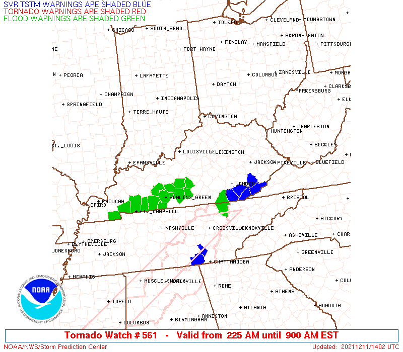
Watch 561 Status Report Messages:
STATUS REPORT #5 ON WW 561

VALID 111235Z - 111340Z

SEVERE WEATHER THREAT CONTINUES RIGHT OF A LINE FROM 45 SW LOZ TO
10 SSW LOZ TO 15 NE LOZ TO 25 W JKL TO 30 NNW JKL TO 40 WSW HTS
TO 10 WSW HTS.

..LEITMAN..12/11/21

ATTN...WFO...LMK...JKL...

&&

STATUS REPORT FOR WT 561

SEVERE WEATHER THREAT CONTINUES FOR THE FOLLOWING AREAS

KYC063-109-129-147-165-175-189-235-237-111340-

KY
.    KENTUCKY COUNTIES INCLUDED ARE

ELLIOTT 	     JACKSON		 LEE
MCCREARY	     MENIFEE		 MORGAN
OWSLEY		     WHITLEY		 WOLFE
$$


THE WATCH STATUS MESSAGE IS FOR GUIDANCE PURPOSES ONLY.  PLEASE
REFER TO WATCH COUNTY NOTIFICATION STATEMENTS FOR OFFICIAL
INFORMATION ON COUNTIES...INDEPENDENT CITIES AND MARINE ZONES
CLEARED FROM SEVERE THUNDERSTORM AND TORNADO WATCHES.
$$

STATUS REPORT #4 ON WW 561

VALID 111140Z - 111240Z

SEVERE WEATHER THREAT CONTINUES RIGHT OF A LINE FROM 35 SW LOZ TO
40 WNW LOZ TO 30 SSE LEX TO 40 WSW HTS TO 20 W HTS.

FOR ADDITIONAL INFORMATION SEE MESOSCALE DISCUSSION 2018

..LEITMAN..12/11/21

ATTN...WFO...LMK...JKL...

&&

STATUS REPORT FOR WT 561

SEVERE WEATHER THREAT CONTINUES FOR THE FOLLOWING AREAS

KYC063-065-079-109-125-129-137-147-151-165-175-189-197-199-203-
235-237-111240-

KY
.    KENTUCKY COUNTIES INCLUDED ARE

ELLIOTT 	     ESTILL		 GARRARD
JACKSON 	     LAUREL		 LEE
LINCOLN 	     MCCREARY		 MADISON
MENIFEE 	     MORGAN		 OWSLEY
POWELL		     PULASKI		 ROCKCASTLE
WHITLEY 	     WOLFE
$$


THE WATCH STATUS MESSAGE IS FOR GUIDANCE PURPOSES ONLY.  PLEASE
REFER TO WATCH COUNTY NOTIFICATION STATEMENTS FOR OFFICIAL
INFORMATION ON COUNTIES...INDEPENDENT CITIES AND MARINE ZONES
CLEARED FROM SEVERE THUNDERSTORM AND TORNADO WATCHES.
$$

STATUS REPORT #3 ON WW 561

VALID 111050Z - 111140Z

SEVERE WEATHER THREAT CONTINUES RIGHT OF A LINE FROM 40 ESE BWG
TO 45 ENE BWG TO 40 WSW HTS TO 35 WNW HTS.

..LEITMAN..12/11/21

ATTN...WFO...LMK...JKL...

&&

STATUS REPORT FOR WT 561

SEVERE WEATHER THREAT CONTINUES FOR THE FOLLOWING AREAS

KYC001-045-053-057-063-065-079-087-109-125-129-137-151-155-165-
169-171-175-189-197-199-203-205-207-231-237-111140-

KY
.    KENTUCKY COUNTIES INCLUDED ARE

ADAIR		     CASEY		 CLINTON
CUMBERLAND	     ELLIOTT		 ESTILL
GARRARD 	     GREEN		 JACKSON
LAUREL		     LEE		 LINCOLN
MADISON 	     MARION		 MENIFEE
METCALFE	     MONROE		 MORGAN
OWSLEY		     POWELL		 PULASKI
ROCKCASTLE	     ROWAN		 RUSSELL
WAYNE		     WOLFE
$$


THE WATCH STATUS MESSAGE IS FOR GUIDANCE PURPOSES ONLY.  PLEASE
REFER TO WATCH COUNTY NOTIFICATION STATEMENTS FOR OFFICIAL
INFORMATION ON COUNTIES...INDEPENDENT CITIES AND MARINE ZONES
CLEARED FROM SEVERE THUNDERSTORM AND TORNADO WATCHES.
$$

STATUS REPORT #2 ON WW 561

VALID 110950Z - 111040Z

SEVERE WEATHER THREAT CONTINUES RIGHT OF A LINE FROM 30 SSW BWG
TO 25 NE BWG TO 15 SE LEX TO 35 NE LEX.

..SQUITIERI..12/11/21

ATTN...WFO...LMK...JKL...

&&

STATUS REPORT FOR WT 561

SEVERE WEATHER THREAT CONTINUES FOR THE FOLLOWING AREAS

KYC001-003-009-011-021-045-049-053-057-061-063-065-069-079-087-
109-125-129-137-151-155-165-169-171-173-175-181-189-197-199-203-
205-207-213-217-227-231-237-111040-

KY
.    KENTUCKY COUNTIES INCLUDED ARE

ADAIR		     ALLEN		 BARREN
BATH		     BOYLE		 CASEY
CLARK		     CLINTON		 CUMBERLAND
EDMONSON	     ELLIOTT		 ESTILL
FLEMING 	     GARRARD		 GREEN
JACKSON 	     LAUREL		 LEE
LINCOLN 	     MADISON		 MARION
MENIFEE 	     METCALFE		 MONROE
MONTGOMERY	     MORGAN		 NICHOLAS
OWSLEY		     POWELL		 PULASKI
ROCKCASTLE	     ROWAN		 RUSSELL
SIMPSON 	     TAYLOR		 WARREN
WAYNE		     WOLFE
$$


THE WATCH STATUS MESSAGE IS FOR GUIDANCE PURPOSES ONLY.  PLEASE
REFER TO WATCH COUNTY NOTIFICATION STATEMENTS FOR OFFICIAL
INFORMATION ON COUNTIES...INDEPENDENT CITIES AND MARINE ZONES
CLEARED FROM SEVERE THUNDERSTORM AND TORNADO WATCHES.
$$

STATUS REPORT #1 ON WW 561

VALID 110855Z - 110940Z

THE SEVERE WEATHER THREAT CONTINUES ACROSS THE ENTIRE WATCH AREA.

..EDWARDS..12/11/21

ATTN...WFO...LMK...JKL...

&&

STATUS REPORT FOR WT 561

SEVERE WEATHER THREAT CONTINUES FOR THE FOLLOWING AREAS

KYC001-003-005-009-011-017-021-029-045-049-053-057-061-063-065-
067-069-073-079-085-087-093-097-099-109-113-123-125-129-137-151-
155-165-167-169-171-173-175-179-181-189-197-199-203-205-207-209-
213-215-217-227-229-231-237-239-110940-

KY
.    KENTUCKY COUNTIES INCLUDED ARE

ADAIR		     ALLEN		 ANDERSON
BARREN		     BATH		 BOURBON
BOYLE		     BULLITT		 CASEY
CLARK		     CLINTON		 CUMBERLAND
EDMONSON	     ELLIOTT		 ESTILL
FAYETTE 	     FLEMING		 FRANKLIN
GARRARD 	     GRAYSON		 GREEN
HARDIN		     HARRISON		 HART
JACKSON 	     JESSAMINE		 LARUE
LAUREL		     LEE		 LINCOLN
MADISON 	     MARION		 MENIFEE
MERCER		     METCALFE		 MONROE
MONTGOMERY	     MORGAN		 NELSON
NICHOLAS	     OWSLEY		 POWELL
PULASKI 	     ROCKCASTLE 	 ROWAN
RUSSELL 	     SCOTT		 SIMPSON
SPENCER 	     TAYLOR		 WARREN
WASHINGTON	     WAYNE		 WOLFE
WOODFORD
$$


THE WATCH STATUS MESSAGE IS FOR GUIDANCE PURPOSES ONLY.  PLEASE
REFER TO WATCH COUNTY NOTIFICATION STATEMENTS FOR OFFICIAL
INFORMATION ON COUNTIES...INDEPENDENT CITIES AND MARINE ZONES
CLEARED FROM SEVERE THUNDERSTORM AND TORNADO WATCHES.
$$
Note:
Click for Complete Product Text.
Tornadoes
Probability of 2 or more tornadoes
|
High (70%)
|
Probability of 1 or more strong (EF2-EF5) tornadoes
|
Mod (40%)
|
Wind
Probability of 10 or more severe wind events
|
Mod (60%)
|
Probability of 1 or more wind events > 65 knots
|
Mod (40%)
|
Hail
Probability of 10 or more severe hail events
|
Low (<5%)
|
Probability of 1 or more hailstones > 2 inches
|
Low (<5%)
|
Combined Severe Hail/Wind
Probability of 6 or more combined severe hail/wind events
|
High (70%)
|
For each watch, probabilities for particular events inside the watch
(listed above in each table) are determined by the issuing forecaster.
The "Low" category contains probability values ranging from less than 2%
to 20% (EF2-EF5 tornadoes), less than 5% to 20% (all other probabilities),
"Moderate" from 30% to 60%, and "High" from 70% to greater than 95%.
High values are bolded and lighter in color to provide awareness of
an increased threat for a particular event.


 @NWSSPC