 Note:
The expiration time in the watch graphic is amended if the watch is
replaced, cancelled or extended.
Note:
Note:
The expiration time in the watch graphic is amended if the watch is
replaced, cancelled or extended.
Note: Click for
Watch Status Reports.
SEL0
URGENT - IMMEDIATE BROADCAST REQUESTED
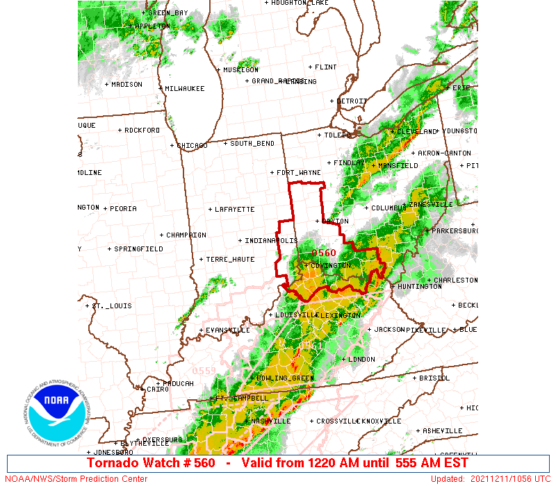
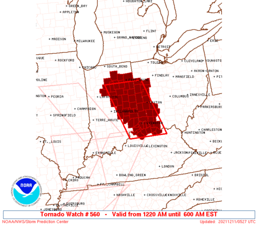
Tornado Watch Number 560
NWS Storm Prediction Center Norman OK
1220 AM EST Sat Dec 11 2021
The NWS Storm Prediction Center has issued a
* Tornado Watch for portions of
Northern and eastern Indiana
Northern Kentucky
Western Ohio
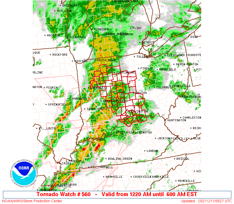
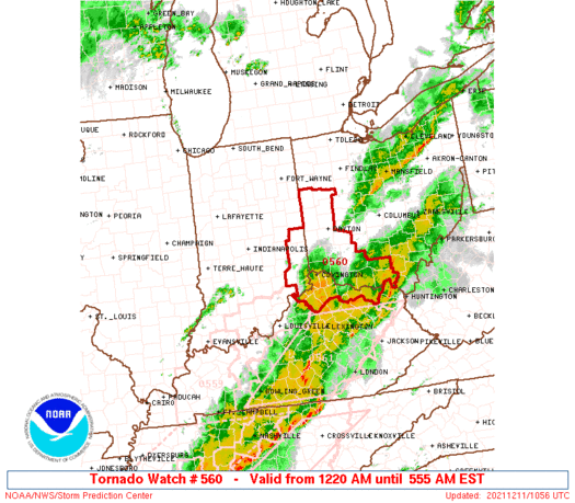
* Effective this Saturday morning from 1220 AM until 600 AM EST.
* Primary threats include...
A couple tornadoes possible
Scattered damaging winds likely with isolated significant gusts
to 75 mph possible
SUMMARY...A linear cluster should spread east with mainly a damaging
wind threat. However, a couple tornadoes will be possible with any
embedded supercell/mesovortex, especially towards the Ohio River.
The tornado watch area is approximately along and 55 statute miles
east and west of a line from 45 miles north of Muncie IN to 45 miles
south of Cincinnati OH. For a complete depiction of the watch see
the associated watch outline update (WOUS64 KWNS WOU0).
PRECAUTIONARY/PREPAREDNESS ACTIONS...
REMEMBER...A Tornado Watch means conditions are favorable for
tornadoes and severe thunderstorms in and close to the watch
area. Persons in these areas should be on the lookout for
threatening weather conditions and listen for later statements
and possible warnings.
&&
OTHER WATCH INFORMATION...CONTINUE...WW 554...WW 557...WW
558...WW 559...
AVIATION...Tornadoes and a few severe thunderstorms with hail
surface and aloft to 0.5 inches. Extreme turbulence and surface wind
gusts to 65 knots. A few cumulonimbi with maximum tops to 350. Mean
storm motion vector 24040.
...Grams

   SEL0

   URGENT - IMMEDIATE BROADCAST REQUESTED
   Tornado Watch Number 560
   NWS Storm Prediction Center Norman OK
   1220 AM EST Sat Dec 11 2021

   The NWS Storm Prediction Center has issued a

   * Tornado Watch for portions of
     Northern and eastern Indiana
     Northern Kentucky
     Western Ohio

   * Effective this Saturday morning from 1220 AM until 600 AM EST.

   * Primary threats include...
     A couple tornadoes possible
     Scattered damaging winds likely with isolated significant gusts
       to 75 mph possible

   SUMMARY...A linear cluster should spread east with mainly a damaging
   wind threat. However, a couple tornadoes will be possible with any
   embedded supercell/mesovortex, especially towards the Ohio River.

   The tornado watch area is approximately along and 55 statute miles
   east and west of a line from 45 miles north of Muncie IN to 45 miles
   south of Cincinnati OH. For a complete depiction of the watch see
   the associated watch outline update (WOUS64 KWNS WOU0).

   PRECAUTIONARY/PREPAREDNESS ACTIONS...

   REMEMBER...A Tornado Watch means conditions are favorable for
   tornadoes and severe thunderstorms in and close to the watch
   area. Persons in these areas should be on the lookout for
   threatening weather conditions and listen for later statements
   and possible warnings.

   &&

   OTHER WATCH INFORMATION...CONTINUE...WW 554...WW 557...WW
   558...WW 559...

   AVIATION...Tornadoes and a few severe thunderstorms with hail
   surface and aloft to 0.5 inches. Extreme turbulence and surface wind
   gusts to 65 knots. A few cumulonimbi with maximum tops to 350. Mean
   storm motion vector 24040.

   ...Grams
 Note:
The Aviation Watch (SAW) product is an approximation to the watch area.
The actual watch is depicted by the shaded areas.
Note:
The Aviation Watch (SAW) product is an approximation to the watch area.
The actual watch is depicted by the shaded areas.
   SAW0
   WW 560 TORNADO IN KY OH 110520Z - 111100Z
   AXIS..55 STATUTE MILES EAST AND WEST OF LINE..
   45N MIE/MUNCIE IN/ - 45S LUK/CINCINNATI OH/
   ..AVIATION COORDS.. 50NM E/W /11WSW FWA - 37SSE CVG/
   HAIL SURFACE AND ALOFT..0.5 INCH. WIND GUSTS..65 KNOTS.
   MAX TOPS TO 350. MEAN STORM MOTION VECTOR 24040.

   LAT...LON 40908435 38438340 38438544 40908645

   THIS IS AN APPROXIMATION TO THE WATCH AREA.  FOR A
   COMPLETE DEPICTION OF THE WATCH SEE WOUS64 KWNS
   FOR WOU0.
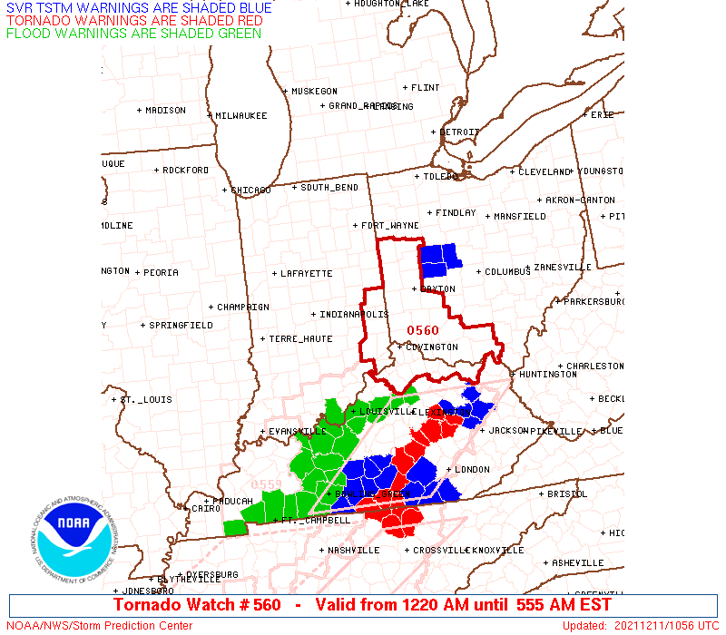
Watch 560 Status Report Messages:
STATUS REPORT #5 ON WW 560

VALID 111045Z - 111140Z

SEVERE WEATHER THREAT CONTINUES RIGHT OF A LINE FROM 45 W HTS TO
15 SE DAY TO 20 ENE DAY.

..LEITMAN..12/11/21

ATTN...WFO...IWX...IND...ILN...

&&

STATUS REPORT FOR WT 560

SEVERE WEATHER THREAT CONTINUES FOR THE FOLLOWING AREAS

KYC135-111140-

KY
.    KENTUCKY COUNTIES INCLUDED ARE

LEWIS
$$


OHC001-027-057-071-131-145-111140-

OH
.    OHIO COUNTIES INCLUDED ARE

ADAMS		     CLINTON		 GREENE
HIGHLAND	     PIKE		 SCIOTO
$$


THE WATCH STATUS MESSAGE IS FOR GUIDANCE PURPOSES ONLY.  PLEASE
REFER TO WATCH COUNTY NOTIFICATION STATEMENTS FOR OFFICIAL
INFORMATION ON COUNTIES...INDEPENDENT CITIES AND MARINE ZONES
CLEARED FROM SEVERE THUNDERSTORM AND TORNADO WATCHES.
$$

STATUS REPORT #4 ON WW 560

VALID 110940Z - 111040Z

SEVERE WEATHER THREAT CONTINUES RIGHT OF A LINE FROM 50 N SDF TO
40 SSE MIE TO 40 NNE DAY.

..SQUITIERI..12/11/21

ATTN...WFO...IWX...IND...ILN...

&&

STATUS REPORT FOR WT 560

SEVERE WEATHER THREAT CONTINUES FOR THE FOLLOWING AREAS

INC029-047-115-137-155-161-111040-

IN
.    INDIANA COUNTIES INCLUDED ARE

DEARBORN	     FRANKLIN		 OHIO
RIPLEY		     SWITZERLAND	 UNION
$$


KYC015-023-037-041-077-081-117-135-161-187-191-201-111040-

KY
.    KENTUCKY COUNTIES INCLUDED ARE

BOONE		     BRACKEN		 CAMPBELL
CARROLL 	     GALLATIN		 GRANT
KENTON		     LEWIS		 MASON
OWEN		     PENDLETON		 ROBERTSON
$$


OHC001-015-017-025-027-057-061-071-109-113-131-135-145-149-165-
111040-

OH
.    OHIO COUNTIES INCLUDED ARE

ADAMS		     BROWN		 BUTLER
CLERMONT	     CLINTON		 GREENE
HAMILTON	     HIGHLAND		 MIAMI
MONTGOMERY	     PIKE		 PREBLE
SCIOTO		     SHELBY		 WARREN
$$


THE WATCH STATUS MESSAGE IS FOR GUIDANCE PURPOSES ONLY.  PLEASE
REFER TO WATCH COUNTY NOTIFICATION STATEMENTS FOR OFFICIAL
INFORMATION ON COUNTIES...INDEPENDENT CITIES AND MARINE ZONES
CLEARED FROM SEVERE THUNDERSTORM AND TORNADO WATCHES.
$$

STATUS REPORT #3 ON WW 560

VALID 110845Z - 110940Z

SEVERE WEATHER THREAT CONTINUES RIGHT OF A LINE FROM 45 E BMG TO
30 SSE MIE TO 40 SW FDY.

..EDWARDS..12/11/21

ATTN...WFO...IWX...IND...ILN...

&&

STATUS REPORT FOR WT 560

SEVERE WEATHER THREAT CONTINUES FOR THE FOLLOWING AREAS

INC029-031-041-047-065-115-135-137-139-155-161-177-110940-

IN
.    INDIANA COUNTIES INCLUDED ARE

DEARBORN	     DECATUR		 FAYETTE
FRANKLIN	     HENRY		 OHIO
RANDOLPH	     RIPLEY		 RUSH
SWITZERLAND	     UNION		 WAYNE
$$


KYC015-023-037-041-077-081-117-135-161-187-191-201-110940-

KY
.    KENTUCKY COUNTIES INCLUDED ARE

BOONE		     BRACKEN		 CAMPBELL
CARROLL 	     GALLATIN		 GRANT
KENTON		     LEWIS		 MASON
OWEN		     PENDLETON		 ROBERTSON
$$


OHC001-011-015-017-025-027-037-057-061-071-109-113-131-135-145-
149-165-110940-

OH
.    OHIO COUNTIES INCLUDED ARE

ADAMS		     AUGLAIZE		 BROWN
BUTLER		     CLERMONT		 CLINTON
DARKE		     GREENE		 HAMILTON
HIGHLAND	     MIAMI		 MONTGOMERY
PIKE		     PREBLE		 SCIOTO
SHELBY		     WARREN
$$


THE WATCH STATUS MESSAGE IS FOR GUIDANCE PURPOSES ONLY.  PLEASE
REFER TO WATCH COUNTY NOTIFICATION STATEMENTS FOR OFFICIAL
INFORMATION ON COUNTIES...INDEPENDENT CITIES AND MARINE ZONES
CLEARED FROM SEVERE THUNDERSTORM AND TORNADO WATCHES.
$$

STATUS REPORT #2 ON WW 560

VALID 110800Z - 110940Z

SEVERE WEATHER THREAT CONTINUES RIGHT OF A LINE FROM 15 NE IND TO
10 N MIE TO 25 WSW FDY.

FOR ADDITIONAL INFORMATION SEE MESOSCALE DISCUSSION 2012

..LEITMAN..12/11/21

ATTN...WFO...IWX...IND...ILN...

&&

STATUS REPORT FOR WT 560

SEVERE WEATHER THREAT CONTINUES FOR THE FOLLOWING AREAS

INC029-031-035-041-047-059-065-075-095-115-135-137-139-145-155-
161-177-110940-

IN
.    INDIANA COUNTIES INCLUDED ARE

DEARBORN	     DECATUR		 DELAWARE
FAYETTE 	     FRANKLIN		 HANCOCK
HENRY		     JAY		 MADISON
OHIO		     RANDOLPH		 RIPLEY
RUSH		     SHELBY		 SWITZERLAND
UNION		     WAYNE
$$


KYC015-023-037-041-077-081-117-161-187-191-201-110940-

KY
.    KENTUCKY COUNTIES INCLUDED ARE

BOONE		     BRACKEN		 CAMPBELL
CARROLL 	     GALLATIN		 GRANT
KENTON		     MASON		 OWEN
PENDLETON	     ROBERTSON
$$


OHC003-011-015-017-025-027-037-057-061-107-109-113-135-149-165-
110940-

OH
.    OHIO COUNTIES INCLUDED ARE

ALLEN		     AUGLAIZE		 BROWN
BUTLER		     CLERMONT		 CLINTON
DARKE		     GREENE		 HAMILTON
MERCER		     MIAMI		 MONTGOMERY
PREBLE		     SHELBY		 WARREN
$$


THE WATCH STATUS MESSAGE IS FOR GUIDANCE PURPOSES ONLY.  PLEASE
REFER TO WATCH COUNTY NOTIFICATION STATEMENTS FOR OFFICIAL
INFORMATION ON COUNTIES...INDEPENDENT CITIES AND MARINE ZONES
CLEARED FROM SEVERE THUNDERSTORM AND TORNADO WATCHES.
$$

STATUS REPORT #1 ON WW 560

VALID 110610Z - 110740Z

THE SEVERE WEATHER THREAT CONTINUES ACROSS THE ENTIRE WATCH AREA.

..EDWARDS..12/11/21

ATTN...WFO...IWX...IND...ILN...

&&

STATUS REPORT FOR WT 560

SEVERE WEATHER THREAT CONTINUES FOR THE FOLLOWING AREAS

INC001-003-009-015-017-029-031-035-041-047-049-053-057-059-065-
067-069-075-085-095-103-115-135-137-139-145-155-159-161-169-177-
179-183-110740-

IN
.    INDIANA COUNTIES INCLUDED ARE

ADAMS		     ALLEN		 BLACKFORD
CARROLL 	     CASS		 DEARBORN
DECATUR 	     DELAWARE		 FAYETTE
FRANKLIN	     FULTON		 GRANT
HAMILTON	     HANCOCK		 HENRY
HOWARD		     HUNTINGTON 	 JAY
KOSCIUSKO	     MADISON		 MIAMI
OHIO		     RANDOLPH		 RIPLEY
RUSH		     SHELBY		 SWITZERLAND
TIPTON		     UNION		 WABASH
WAYNE		     WELLS		 WHITLEY
$$


KYC015-023-037-041-077-081-117-161-187-191-201-110740-

KY
.    KENTUCKY COUNTIES INCLUDED ARE

BOONE		     BRACKEN		 CAMPBELL
CARROLL 	     GALLATIN		 GRANT
KENTON		     MASON		 OWEN
PENDLETON	     ROBERTSON
$$


OHC003-011-015-017-025-027-037-057-061-107-109-113-135-149-161-
165-110740-

OH
.    OHIO COUNTIES INCLUDED ARE

ALLEN		     AUGLAIZE		 BROWN
BUTLER		     CLERMONT		 CLINTON
DARKE		     GREENE		 HAMILTON
MERCER		     MIAMI		 MONTGOMERY
PREBLE		     SHELBY		 VAN WERT
WARREN
$$


THE WATCH STATUS MESSAGE IS FOR GUIDANCE PURPOSES ONLY.  PLEASE
REFER TO WATCH COUNTY NOTIFICATION STATEMENTS FOR OFFICIAL
INFORMATION ON COUNTIES...INDEPENDENT CITIES AND MARINE ZONES
CLEARED FROM SEVERE THUNDERSTORM AND TORNADO WATCHES.
$$
Note:
Click for Complete Product Text.
Tornadoes
Probability of 2 or more tornadoes
|
Mod (40%)
|
Probability of 1 or more strong (EF2-EF5) tornadoes
|
Low (20%)
|
Wind
Probability of 10 or more severe wind events
|
Mod (60%)
|
Probability of 1 or more wind events > 65 knots
|
Mod (40%)
|
Hail
Probability of 10 or more severe hail events
|
Low (<5%)
|
Probability of 1 or more hailstones > 2 inches
|
Low (<5%)
|
Combined Severe Hail/Wind
Probability of 6 or more combined severe hail/wind events
|
High (70%)
|
For each watch, probabilities for particular events inside the watch
(listed above in each table) are determined by the issuing forecaster.
The "Low" category contains probability values ranging from less than 2%
to 20% (EF2-EF5 tornadoes), less than 5% to 20% (all other probabilities),
"Moderate" from 30% to 60%, and "High" from 70% to greater than 95%.
High values are bolded and lighter in color to provide awareness of
an increased threat for a particular event.


 @NWSSPC