Note:
The expiration time in the watch graphic is amended if the watch is
replaced, cancelled or extended.
Note:
Note:
The expiration time in the watch graphic is amended if the watch is
replaced, cancelled or extended.
Note: Click for
Watch Status Reports.
SEL8
URGENT - IMMEDIATE BROADCAST REQUESTED
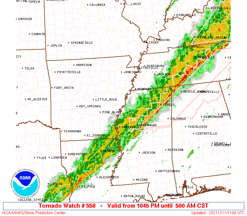
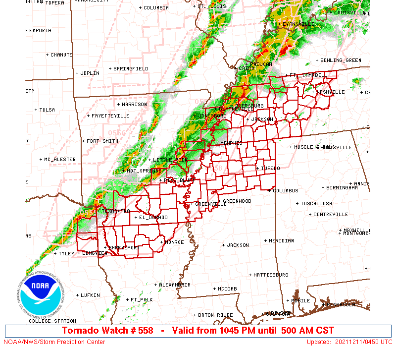
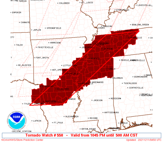
Tornado Watch Number 558
NWS Storm Prediction Center Norman OK
1045 PM CST Fri Dec 10 2021
The NWS Storm Prediction Center has issued a
* Tornado Watch for portions of
Southern and eastern Arkansas
Northern Louisiana
Northern Mississippi
Western to middle Tennessee
Far northeast Texas
* Effective this Friday night and Saturday morning from 1045 PM
until 500 AM CST.
* Primary threats include...
A few tornadoes likely with a couple intense tornadoes possible
Scattered damaging winds likely with isolated significant gusts
to 75 mph possible
Isolated large hail events to 1.5 inches in diameter possible
SUMMARY...Several clusters with embedded supercells should
consolidate into a broader QLCS overnight. A couple discrete
supercells may yet form in the open warm sector from northern
Louisiana into northern Mississippi.
The tornado watch area is approximately along and 75 statute miles
east and west of a line from 35 miles northwest of Nashville TN to
20 miles southeast of Shreveport LA. For a complete depiction of the
watch see the associated watch outline update (WOUS64 KWNS WOU8).
PRECAUTIONARY/PREPAREDNESS ACTIONS...
REMEMBER...A Tornado Watch means conditions are favorable for
tornadoes and severe thunderstorms in and close to the watch
area. Persons in these areas should be on the lookout for
threatening weather conditions and listen for later statements
and possible warnings.
&&
OTHER WATCH INFORMATION...CONTINUE...WW 552...WW 553...WW
554...WW 555...WW 556...WW 557...
AVIATION...Tornadoes and a few severe thunderstorms with hail
surface and aloft to 1.5 inches. Extreme turbulence and surface wind
gusts to 65 knots. A few cumulonimbi with maximum tops to 450. Mean
storm motion vector 24040.
...Grams
 Note:
The Aviation Watch (SAW) product is an approximation to the watch area.
The actual watch is depicted by the shaded areas.
Note:
The Aviation Watch (SAW) product is an approximation to the watch area.
The actual watch is depicted by the shaded areas.
   SAW8
   WW 558 TORNADO AR LA MS TN TX 110445Z - 111100Z
   AXIS..75 STATUTE MILES EAST AND WEST OF LINE..
   35NW BNA/NASHVILLE TN/ - 20SE SHV/SHREVEPORT LA/
   ..AVIATION COORDS.. 65NM E/W /30NW BNA - 33SSE EIC/
   HAIL SURFACE AND ALOFT..1.5 INCHES. WIND GUSTS..65 KNOTS.
   MAX TOPS TO 450. MEAN STORM MOTION VECTOR 24040.

   LAT...LON 36488578 32249230 32249487 36488848

   THIS IS AN APPROXIMATION TO THE WATCH AREA.  FOR A
   COMPLETE DEPICTION OF THE WATCH SEE WOUS64 KWNS
   FOR WOU8.
Watch 558 Status Report Messages:
STATUS REPORT #4 ON WW 558

VALID 110945Z - 111040Z

SEVERE WEATHER THREAT CONTINUES RIGHT OF A LINE FROM 35 NNE IER
TO 30 WNW MLU TO 25 SW GLH TO 40 WSW UOX TO 40 SSW MKL TO 10 NW
BNA TO 20 SSW BWG.

..SQUITIERI..12/11/21

ATTN...WFO...LZK...JAN...SHV...MEG...OHX...

&&

STATUS REPORT FOR WT 558

SEVERE WEATHER THREAT CONTINUES FOR THE FOLLOWING AREAS

ARC017-111040-

AR
.    ARKANSAS COUNTIES INCLUDED ARE

CHICOT
$$


LAC049-067-073-111040-

LA
.    LOUISIANA PARISHES INCLUDED ARE

JACKSON 	     MOREHOUSE		 OUACHITA
$$


MSC003-009-013-017-043-057-071-081-083-095-115-117-133-135-139-
141-145-151-161-111040-

MS
.    MISSISSIPPI COUNTIES INCLUDED ARE

ALCORN		     BENTON		 CALHOUN
CHICKASAW	     GRENADA		 ITAWAMBA
LAFAYETTE	     LEE		 LEFLORE
MONROE		     PONTOTOC		 PRENTISS
SUNFLOWER	     TALLAHATCHIE	 TIPPAH
TISHOMINGO	     UNION		 WASHINGTON
YALOBUSHA
$$


TNC037-071-081-099-101-109-111-119-149-165-169-181-187-189-
111040-

TN
.    TENNESSEE COUNTIES INCLUDED ARE

DAVIDSON	     HARDIN		 HICKMAN
LAWRENCE	     LEWIS		 MCNAIRY
MACON		     MAURY		 RUTHERFORD
SUMNER		     TROUSDALE		 WAYNE
WILLIAMSON	     WILSON
$$


THE WATCH STATUS MESSAGE IS FOR GUIDANCE PURPOSES ONLY.  PLEASE
REFER TO WATCH COUNTY NOTIFICATION STATEMENTS FOR OFFICIAL
INFORMATION ON COUNTIES...INDEPENDENT CITIES AND MARINE ZONES
CLEARED FROM SEVERE THUNDERSTORM AND TORNADO WATCHES.
$$

STATUS REPORT #3 ON WW 558

VALID 110840Z - 110940Z

SEVERE WEATHER THREAT CONTINUES RIGHT OF A LINE FROM 20 SE SHV TO
20 WNW GLH TO 35 SSW MEM TO 15 ENE MEM TO 30 ESE MKL TO 35 S CKV
TO 5 S CKV.

FOR ADDITIONAL INFORMATION SEE SPC MESOSCALE DISCUSSION 2013.

..EDWARDS..12/11/21

ATTN...WFO...LZK...JAN...SHV...MEG...OHX...

&&

STATUS REPORT FOR WT 558

SEVERE WEATHER THREAT CONTINUES FOR THE FOLLOWING AREAS

ARC003-017-110940-

AR
.    ARKANSAS COUNTIES INCLUDED ARE

ASHLEY		     CHICOT
$$


LAC013-049-061-067-073-111-110940-

LA
.    LOUISIANA PARISHES INCLUDED ARE

BIENVILLE	     JACKSON		 LINCOLN
MOREHOUSE	     OUACHITA		 UNION
$$


MSC003-009-011-013-017-033-043-057-071-081-083-093-095-107-115-
117-119-133-135-137-139-141-143-145-151-161-110940-

MS
.    MISSISSIPPI COUNTIES INCLUDED ARE

ALCORN		     BENTON		 BOLIVAR
CALHOUN 	     CHICKASAW		 DESOTO
GRENADA 	     ITAWAMBA		 LAFAYETTE
LEE		     LEFLORE		 MARSHALL
MONROE		     PANOLA		 PONTOTOC
PRENTISS	     QUITMAN		 SUNFLOWER
TALLAHATCHIE	     TATE		 TIPPAH
TISHOMINGO	     TUNICA		 UNION
WASHINGTON	     YALOBUSHA
$$


TNC021-023-037-039-043-047-069-071-077-081-099-101-109-111-119-
125-135-147-149-157-165-169-181-187-189-110940-

TN
.    TENNESSEE COUNTIES INCLUDED ARE

CHEATHAM	     CHESTER		 DAVIDSON
DECATUR 	     DICKSON		 FAYETTE
HARDEMAN	     HARDIN		 HENDERSON
HICKMAN 	     LAWRENCE		 LEWIS
MCNAIRY 	     MACON		 MAURY
MONTGOMERY	     PERRY		 ROBERTSON
RUTHERFORD	     SHELBY		 SUMNER
TROUSDALE	     WAYNE		 WILLIAMSON
WILSON
$$


THE WATCH STATUS MESSAGE IS FOR GUIDANCE PURPOSES ONLY.  PLEASE
REFER TO WATCH COUNTY NOTIFICATION STATEMENTS FOR OFFICIAL
INFORMATION ON COUNTIES...INDEPENDENT CITIES AND MARINE ZONES
CLEARED FROM SEVERE THUNDERSTORM AND TORNADO WATCHES.
$$

STATUS REPORT #2 ON WW 558

VALID 110805Z - 110940Z

SEVERE WEATHER THREAT CONTINUES RIGHT OF A LINE FROM 20 SSW SHV
TO 20 WSW LLQ TO 50 ENE PBF TO 60 ENE PBF TO 50 W MEM.

..LEITMAN..12/11/21

ATTN...WFO...LZK...JAN...SHV...MEG...OHX...

&&

STATUS REPORT FOR WT 558

SEVERE WEATHER THREAT CONTINUES FOR THE FOLLOWING AREAS

ARC003-011-017-035-041-043-077-093-107-123-139-110940-

AR
.    ARKANSAS COUNTIES INCLUDED ARE

ASHLEY		     BRADLEY		 CHICOT
CRITTENDEN	     DESHA		 DREW
LEE		     MISSISSIPPI	 PHILLIPS
ST. FRANCIS	     UNION
$$


LAC013-015-027-049-061-067-073-111-119-110940-

LA
.    LOUISIANA PARISHES INCLUDED ARE

BIENVILLE	     BOSSIER		 CLAIBORNE
JACKSON 	     LINCOLN		 MOREHOUSE
OUACHITA	     UNION		 WEBSTER
$$


MSC003-009-011-013-017-027-033-043-057-071-081-083-093-095-107-
115-117-119-133-135-137-139-141-143-145-151-161-110940-

MS
.    MISSISSIPPI COUNTIES INCLUDED ARE

ALCORN		     BENTON		 BOLIVAR
CALHOUN 	     CHICKASAW		 COAHOMA
DESOTO		     GRENADA		 ITAWAMBA
LAFAYETTE	     LEE		 LEFLORE
MARSHALL	     MONROE		 PANOLA
PONTOTOC	     PRENTISS		 QUITMAN
SUNFLOWER	     TALLAHATCHIE	 TATE
TIPPAH		     TISHOMINGO 	 TUNICA
UNION		     WASHINGTON 	 YALOBUSHA
$$


TNC005-017-021-023-033-037-039-043-045-047-053-069-071-075-077-
079-081-083-085-097-099-101-109-111-113-119-125-131-135-147-149-
157-161-165-167-169-181-183-187-189-110940-

TN
.    TENNESSEE COUNTIES INCLUDED ARE

BENTON		     CARROLL		 CHEATHAM
CHESTER 	     CROCKETT		 DAVIDSON
DECATUR 	     DICKSON		 DYER
FAYETTE 	     GIBSON		 HARDEMAN
HARDIN		     HAYWOOD		 HENDERSON
HENRY		     HICKMAN		 HOUSTON
HUMPHREYS	     LAUDERDALE 	 LAWRENCE
LEWIS		     MCNAIRY		 MACON
MADISON 	     MAURY		 MONTGOMERY
OBION		     PERRY		 ROBERTSON
RUTHERFORD	     SHELBY		 STEWART
SUMNER		     TIPTON		 TROUSDALE
WAYNE		     WEAKLEY		 WILLIAMSON
WILSON
$$


THE WATCH STATUS MESSAGE IS FOR GUIDANCE PURPOSES ONLY.  PLEASE
REFER TO WATCH COUNTY NOTIFICATION STATEMENTS FOR OFFICIAL
INFORMATION ON COUNTIES...INDEPENDENT CITIES AND MARINE ZONES
CLEARED FROM SEVERE THUNDERSTORM AND TORNADO WATCHES.
$$

STATUS REPORT #1 ON WW 558

VALID 110615Z - 110740Z

THE SEVERE WEATHER THREAT CONTINUES ACROSS THE ENTIRE WATCH AREA.

..EDWARDS..12/11/21

ATTN...WFO...LZK...JAN...SHV...MEG...OHX...

&&

STATUS REPORT FOR WT 558

SEVERE WEATHER THREAT CONTINUES FOR THE FOLLOWING AREAS

ARC001-003-011-013-017-025-027-035-041-043-069-073-077-079-091-
093-095-099-103-107-123-139-110740-

AR
.    ARKANSAS COUNTIES INCLUDED ARE

ARKANSAS	     ASHLEY		 BRADLEY
CALHOUN 	     CHICOT		 CLEVELAND
COLUMBIA	     CRITTENDEN 	 DESHA
DREW		     JEFFERSON		 LAFAYETTE
LEE		     LINCOLN		 MILLER
MISSISSIPPI	     MONROE		 NEVADA
OUACHITA	     PHILLIPS		 ST. FRANCIS
UNION
$$


LAC013-015-017-027-049-061-067-073-111-119-110740-

LA
.    LOUISIANA PARISHES INCLUDED ARE

BIENVILLE	     BOSSIER		 CADDO
CLAIBORNE	     JACKSON		 LINCOLN
MOREHOUSE	     OUACHITA		 UNION
WEBSTER
$$


MSC003-009-011-013-017-027-033-043-057-071-081-083-093-095-107-
115-117-119-133-135-137-139-141-143-145-151-161-110740-

MS
.    MISSISSIPPI COUNTIES INCLUDED ARE

ALCORN		     BENTON		 BOLIVAR
CALHOUN 	     CHICKASAW		 COAHOMA
DESOTO		     GRENADA		 ITAWAMBA
LAFAYETTE	     LEE		 LEFLORE
MARSHALL	     MONROE		 PANOLA
PONTOTOC	     PRENTISS		 QUITMAN
SUNFLOWER	     TALLAHATCHIE	 TATE
TIPPAH		     TISHOMINGO 	 TUNICA
UNION		     WASHINGTON 	 YALOBUSHA
$$


TNC005-017-021-023-033-037-039-043-045-047-053-069-071-075-077-
079-081-083-085-097-099-101-109-111-113-119-125-131-135-147-149-
157-161-165-167-169-181-183-187-189-110740-

TN
.    TENNESSEE COUNTIES INCLUDED ARE

BENTON		     CARROLL		 CHEATHAM
CHESTER 	     CROCKETT		 DAVIDSON
DECATUR 	     DICKSON		 DYER
FAYETTE 	     GIBSON		 HARDEMAN
HARDIN		     HAYWOOD		 HENDERSON
HENRY		     HICKMAN		 HOUSTON
HUMPHREYS	     LAUDERDALE 	 LAWRENCE
LEWIS		     MCNAIRY		 MACON
MADISON 	     MAURY		 MONTGOMERY
OBION		     PERRY		 ROBERTSON
RUTHERFORD	     SHELBY		 STEWART
SUMNER		     TIPTON		 TROUSDALE
WAYNE		     WEAKLEY		 WILLIAMSON
WILSON
$$


TXC203-315-110740-

TX
.    TEXAS COUNTIES INCLUDED ARE

HARRISON	     MARION
$$


THE WATCH STATUS MESSAGE IS FOR GUIDANCE PURPOSES ONLY.  PLEASE
REFER TO WATCH COUNTY NOTIFICATION STATEMENTS FOR OFFICIAL
INFORMATION ON COUNTIES...INDEPENDENT CITIES AND MARINE ZONES
CLEARED FROM SEVERE THUNDERSTORM AND TORNADO WATCHES.
$$
Note:
Click for Complete Product Text.
Tornadoes
Probability of 2 or more tornadoes
|
High (70%)
|
Probability of 1 or more strong (EF2-EF5) tornadoes
|
Mod (50%)
|
Wind
Probability of 10 or more severe wind events
|
Mod (60%)
|
Probability of 1 or more wind events > 65 knots
|
Mod (30%)
|
Hail
Probability of 10 or more severe hail events
|
Low (20%)
|
Probability of 1 or more hailstones > 2 inches
|
Low (20%)
|
Combined Severe Hail/Wind
Probability of 6 or more combined severe hail/wind events
|
High (80%)
|
For each watch, probabilities for particular events inside the watch
(listed above in each table) are determined by the issuing forecaster.
The "Low" category contains probability values ranging from less than 2%
to 20% (EF2-EF5 tornadoes), less than 5% to 20% (all other probabilities),
"Moderate" from 30% to 60%, and "High" from 70% to greater than 95%.
High values are bolded and lighter in color to provide awareness of
an increased threat for a particular event.


 @NWSSPC