Note:
The expiration time in the watch graphic is amended if the watch is
replaced, cancelled or extended.
Note:
Note:
The expiration time in the watch graphic is amended if the watch is
replaced, cancelled or extended.
Note: Click for
Watch Status Reports.
SEL8
URGENT - IMMEDIATE BROADCAST REQUESTED
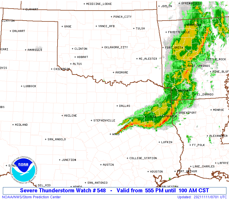
Severe Thunderstorm Watch Number 548
NWS Storm Prediction Center Norman OK
555 PM CST Wed Nov 10 2021
The NWS Storm Prediction Center has issued a
* Severe Thunderstorm Watch for portions of
North-central and northeast Texas
* Effective this Wednesday afternoon and Thursday morning from
555 PM until 100 AM CST.
* Primary threats include...
Scattered large hail and isolated very large hail events to 2.5
inches in diameter possible
Scattered damaging wind gusts to 70 mph possible
A tornado or two possible
SUMMARY...Supercells and eventually a growing band of thunderstorms
are expected to move southeastward across the watch area tonight,
with the threat including parts of the DFW Metroplex. Storms will
offer mainly severe hail and damaging gusts, with a tornado
possible.
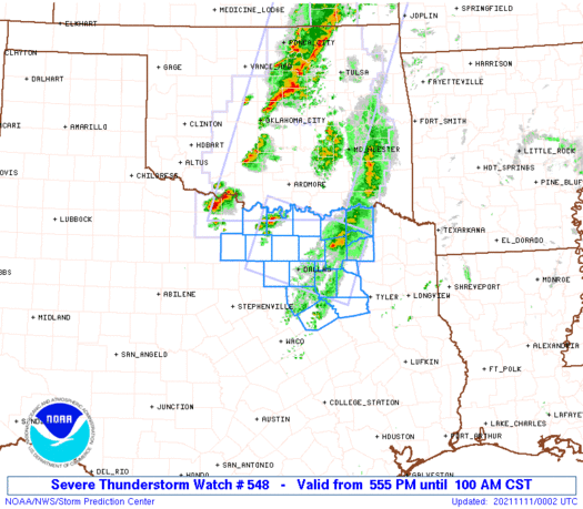
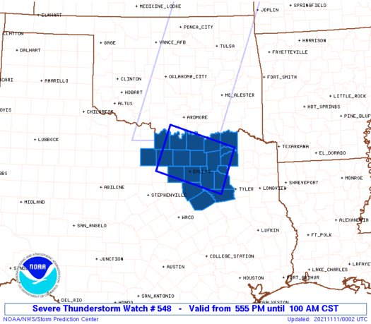
The severe thunderstorm watch area is approximately along and 45
statute miles either side of a line from 50 miles north northwest of
Fort Worth TX to 70 miles east of Dallas TX. For a complete
depiction of the watch see the associated watch outline update
(WOUS64 KWNS WOU8).
PRECAUTIONARY/PREPAREDNESS ACTIONS...
REMEMBER...A Severe Thunderstorm Watch means conditions are
favorable for severe thunderstorms in and close to the watch area.
Persons in these areas should be on the lookout for threatening
weather conditions and listen for later statements and possible
warnings. Severe thunderstorms can and occasionally do produce
tornadoes.
&&
OTHER WATCH INFORMATION...CONTINUE...WW 546...WW 547...
AVIATION...A few severe thunderstorms with hail surface and aloft to
2.5 inches. Extreme turbulence and surface wind gusts to 60 knots. A
few cumulonimbi with maximum tops to 450. Mean storm motion vector
30030.
...Edwards
   SEL8

   URGENT - IMMEDIATE BROADCAST REQUESTED
   Severe Thunderstorm Watch Number 548
   NWS Storm Prediction Center Norman OK
   555 PM CST Wed Nov 10 2021

   The NWS Storm Prediction Center has issued a

   * Severe Thunderstorm Watch for portions of
     North-central and northeast Texas

   * Effective this Wednesday afternoon and Thursday morning from
     555 PM until 100 AM CST.

   * Primary threats include...
     Scattered large hail and isolated very large hail events to 2.5
       inches in diameter possible
     Scattered damaging wind gusts to 70 mph possible
     A tornado or two possible

   SUMMARY...Supercells and eventually a growing band of thunderstorms
   are expected to move southeastward across the watch area tonight,
   with the threat including parts of the DFW Metroplex.  Storms will
   offer mainly severe hail and damaging gusts, with a tornado
   possible.

   The severe thunderstorm watch area is approximately along and 45
   statute miles either side of a line from 50 miles north northwest of
   Fort Worth TX to 70 miles east of Dallas TX. For a complete
   depiction of the watch see the associated watch outline update
   (WOUS64 KWNS WOU8).

   PRECAUTIONARY/PREPAREDNESS ACTIONS...

   REMEMBER...A Severe Thunderstorm Watch means conditions are
   favorable for severe thunderstorms in and close to the watch area.
   Persons in these areas should be on the lookout for threatening
   weather conditions and listen for later statements and possible
   warnings. Severe thunderstorms can and occasionally do produce
   tornadoes.

   &&

   OTHER WATCH INFORMATION...CONTINUE...WW 546...WW 547...

   AVIATION...A few severe thunderstorms with hail surface and aloft to
   2.5 inches. Extreme turbulence and surface wind gusts to 60 knots. A
   few cumulonimbi with maximum tops to 450. Mean storm motion vector
   30030.

   ...Edwards
 Note:
The Aviation Watch (SAW) product is an approximation to the watch area.
The actual watch is depicted by the shaded areas.
Note:
The Aviation Watch (SAW) product is an approximation to the watch area.
The actual watch is depicted by the shaded areas.
   SAW8
   WW 548 SEVERE TSTM TX 102355Z - 110700Z
   AXIS..45 STATUTE MILES EITHER SIDE OF LINE..
   50NNW FTW/FORT WORTH TX/ - 70E DAL/DALLAS TX/
   ..AVIATION COORDS.. 40NM EITHER SIDE /50NW TTT - 52WNW GGG/
   HAIL SURFACE AND ALOFT..2.5 INCHES. WIND GUSTS..60 KNOTS.
   MAX TOPS TO 450. MEAN STORM MOTION VECTOR 30030.

   LAT...LON 34119746 33469540 32229588 32879794

   THIS IS AN APPROXIMATION TO THE WATCH AREA.  FOR A
   COMPLETE DEPICTION OF THE WATCH SEE WOUS64 KWNS
   FOR WOU8.
Watch 548 Status Report Messages:
STATUS REPORT #3 ON WW 548

VALID 110525Z - 110640Z

SEVERE WEATHER THREAT CONTINUES RIGHT OF A LINE FROM 20 SSE FTW
TO 5 ESE DAL TO 35 ESE DAL TO 30 WNW TYR TO 30 N TYR TO 40 SSE
PRX TO 35 ESE PRX.

FOR ADDITIONAL INFORMATION SEE MESOSCALE DISCUSSION 1940

..JEWELL..11/11/21

ATTN...WFO...FWD...

&&

STATUS REPORT FOR WS 548

SEVERE WEATHER THREAT CONTINUES FOR THE FOLLOWING AREAS

TXC139-213-257-349-467-110640-

TX
.    TEXAS COUNTIES INCLUDED ARE

ELLIS		     HENDERSON		 KAUFMAN
NAVARRO 	     VAN ZANDT
$$


THE WATCH STATUS MESSAGE IS FOR GUIDANCE PURPOSES ONLY.  PLEASE
REFER TO WATCH COUNTY NOTIFICATION STATEMENTS FOR OFFICIAL
INFORMATION ON COUNTIES...INDEPENDENT CITIES AND MARINE ZONES
CLEARED FROM SEVERE THUNDERSTORM AND TORNADO WATCHES.
$$

STATUS REPORT #2 ON WW 548

VALID 110440Z - 110540Z

SEVERE WEATHER THREAT CONTINUES RIGHT OF A LINE FROM 20 SW FTW TO
10 NE FTW TO 5 NNW DAL TO 20 E DAL TO 40 E DAL TO 50 SSW PRX TO
35 SSW PRX TO 20 SSE PRX.

..JEWELL..11/11/21

ATTN...WFO...FWD...

&&

STATUS REPORT FOR WS 548

SEVERE WEATHER THREAT CONTINUES FOR THE FOLLOWING AREAS

TXC113-139-213-223-257-349-379-397-439-467-110540-

TX
.    TEXAS COUNTIES INCLUDED ARE

DALLAS		     ELLIS		 HENDERSON
HOPKINS 	     KAUFMAN		 NAVARRO
RAINS		     ROCKWALL		 TARRANT
VAN ZANDT
$$


THE WATCH STATUS MESSAGE IS FOR GUIDANCE PURPOSES ONLY.  PLEASE
REFER TO WATCH COUNTY NOTIFICATION STATEMENTS FOR OFFICIAL
INFORMATION ON COUNTIES...INDEPENDENT CITIES AND MARINE ZONES
CLEARED FROM SEVERE THUNDERSTORM AND TORNADO WATCHES.
$$

STATUS REPORT #1 ON WW 548

VALID 110330Z - 110440Z

SEVERE WEATHER THREAT CONTINUES RIGHT OF A LINE FROM 15 NNE MWL
TO 30 NNE MWL TO 30 N FTW TO 30 SSW GYI TO 25 SSE GYI TO 25 SSE
DUA TO 25 E DUA.

FOR ADDITIONAL INFORMATION SEE MESOSCALE DISCUSSION 1939

..JEWELL..11/11/21

ATTN...WFO...FWD...

&&

STATUS REPORT FOR WS 548

SEVERE WEATHER THREAT CONTINUES FOR THE FOLLOWING AREAS

TXC085-113-119-121-139-147-181-213-223-231-237-257-277-349-379-
397-439-467-497-110440-

TX
.    TEXAS COUNTIES INCLUDED ARE

COLLIN		     DALLAS		 DELTA
DENTON		     ELLIS		 FANNIN
GRAYSON 	     HENDERSON		 HOPKINS
HUNT		     JACK		 KAUFMAN
LAMAR		     NAVARRO		 RAINS
ROCKWALL	     TARRANT		 VAN ZANDT
WISE
$$


THE WATCH STATUS MESSAGE IS FOR GUIDANCE PURPOSES ONLY.  PLEASE
REFER TO WATCH COUNTY NOTIFICATION STATEMENTS FOR OFFICIAL
INFORMATION ON COUNTIES...INDEPENDENT CITIES AND MARINE ZONES
CLEARED FROM SEVERE THUNDERSTORM AND TORNADO WATCHES.
$$
Note:
Click for Complete Product Text.
Tornadoes
Probability of 2 or more tornadoes
|
Low (20%)
|
Probability of 1 or more strong (EF2-EF5) tornadoes
|
Low (5%)
|
Wind
Probability of 10 or more severe wind events
|
Mod (40%)
|
Probability of 1 or more wind events > 65 knots
|
Low (20%)
|
Hail
Probability of 10 or more severe hail events
|
Mod (50%)
|
Probability of 1 or more hailstones > 2 inches
|
Mod (40%)
|
Combined Severe Hail/Wind
Probability of 6 or more combined severe hail/wind events
|
High (80%)
|
For each watch, probabilities for particular events inside the watch
(listed above in each table) are determined by the issuing forecaster.
The "Low" category contains probability values ranging from less than 2%
to 20% (EF2-EF5 tornadoes), less than 5% to 20% (all other probabilities),
"Moderate" from 30% to 60%, and "High" from 70% to greater than 95%.
High values are bolded and lighter in color to provide awareness of
an increased threat for a particular event.


 @NWSSPC