Note:
The expiration time in the watch graphic is amended if the watch is
replaced, cancelled or extended.
Note:
Note:
The expiration time in the watch graphic is amended if the watch is
replaced, cancelled or extended.
Note: Click for
Watch Status Reports.
SEL6
URGENT - IMMEDIATE BROADCAST REQUESTED
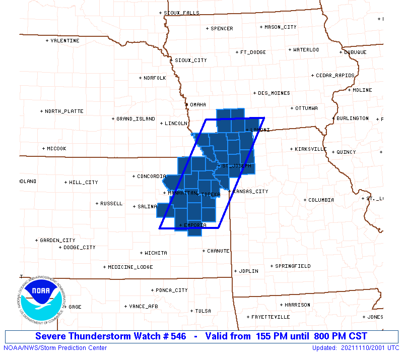
Severe Thunderstorm Watch Number 546
NWS Storm Prediction Center Norman OK
155 PM CST Wed Nov 10 2021
The NWS Storm Prediction Center has issued a
* Severe Thunderstorm Watch for portions of
Southern Iowa
East-central/Northeast Kansas
Northwest Missouri
* Effective this Wednesday afternoon and evening from 155 PM
until 800 PM CST.
* Primary threats include...
Scattered damaging wind gusts to 65 mph possible
Isolated large hail events to 1 inch in diameter possible
A tornado or two possible
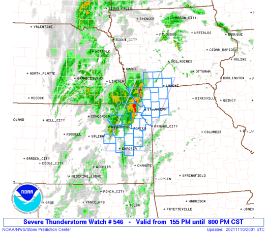
SUMMARY...Clusters of storms will continue to move northeastward
across the region as the air mass continues to modestly destabilize
through the afternoon, with periodic severe storms a possibility
through late afternoon/early evening.
The severe thunderstorm watch area is approximately along and 50
statute miles east and west of a line from 15 miles east southeast
of Emporia KS to 30 miles northwest of Lamoni IA. For a complete
depiction of the watch see the associated watch outline update
(WOUS64 KWNS WOU6).
PRECAUTIONARY/PREPAREDNESS ACTIONS...
REMEMBER...A Severe Thunderstorm Watch means conditions are
favorable for severe thunderstorms in and close to the watch area.
Persons in these areas should be on the lookout for threatening
weather conditions and listen for later statements and possible
warnings. Severe thunderstorms can and occasionally do produce
tornadoes.
&&
AVIATION...A few severe thunderstorms with hail surface and aloft to
1 inch. Extreme turbulence and surface wind gusts to 55 knots. A few
cumulonimbi with maximum tops to 500. Mean storm motion vector
21035.
...Guyer
   SEL6

   URGENT - IMMEDIATE BROADCAST REQUESTED
   Severe Thunderstorm Watch Number 546
   NWS Storm Prediction Center Norman OK
   155 PM CST Wed Nov 10 2021

   The NWS Storm Prediction Center has issued a

   * Severe Thunderstorm Watch for portions of
     Southern Iowa
     East-central/Northeast Kansas
     Northwest Missouri

   * Effective this Wednesday afternoon and evening from 155 PM
     until 800 PM CST.

   * Primary threats include...
     Scattered damaging wind gusts to 65 mph possible
     Isolated large hail events to 1 inch in diameter possible
     A tornado or two possible

   SUMMARY...Clusters of storms will continue to move northeastward
   across the region as the air mass continues to modestly destabilize
   through the afternoon, with periodic severe storms a possibility
   through late afternoon/early evening.

   The severe thunderstorm watch area is approximately along and 50
   statute miles east and west of a line from 15 miles east southeast
   of Emporia KS to 30 miles northwest of Lamoni IA. For a complete
   depiction of the watch see the associated watch outline update
   (WOUS64 KWNS WOU6).

   PRECAUTIONARY/PREPAREDNESS ACTIONS...

   REMEMBER...A Severe Thunderstorm Watch means conditions are
   favorable for severe thunderstorms in and close to the watch area.
   Persons in these areas should be on the lookout for threatening
   weather conditions and listen for later statements and possible
   warnings. Severe thunderstorms can and occasionally do produce
   tornadoes.

   &&

   AVIATION...A few severe thunderstorms with hail surface and aloft to
   1 inch. Extreme turbulence and surface wind gusts to 55 knots. A few
   cumulonimbi with maximum tops to 500. Mean storm motion vector
   21035.

   ...Guyer
 Note:
The Aviation Watch (SAW) product is an approximation to the watch area.
The actual watch is depicted by the shaded areas.
Note:
The Aviation Watch (SAW) product is an approximation to the watch area.
The actual watch is depicted by the shaded areas.
SAW6
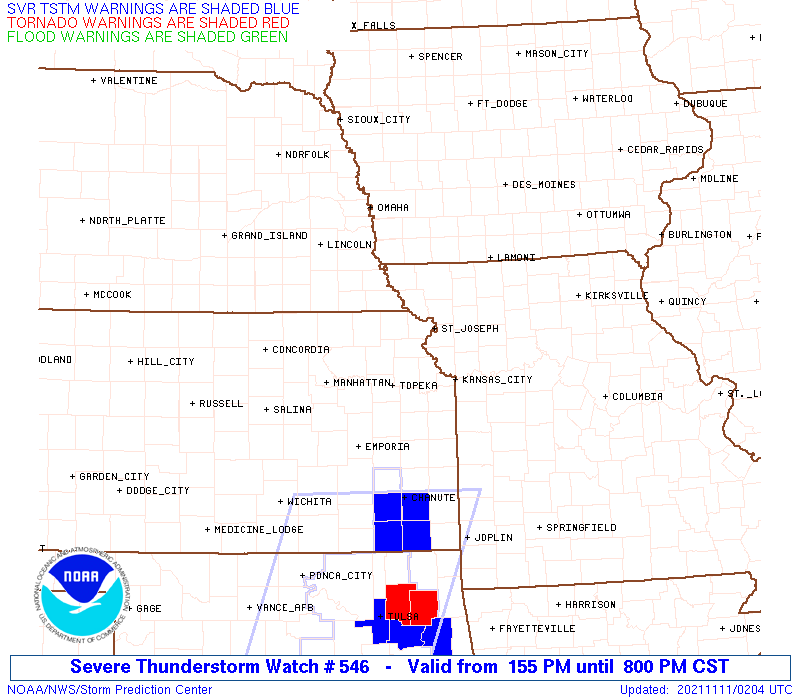
WW 546 SEVERE TSTM IA KS MO 101955Z - 110200Z
AXIS..50 STATUTE MILES EAST AND WEST OF LINE..
15ESE EMP/EMPORIA KS/ - 30NW LWD/LAMONI IA/
..AVIATION COORDS.. 45NM E/W /68W BUM - 44SW DSM/
HAIL SURFACE AND ALOFT..1 INCH. WIND GUSTS..55 KNOTS.
MAX TOPS TO 500. MEAN STORM MOTION VECTOR 21035.
LAT...LON 38249685 40919529 40919338 38249500
THIS IS AN APPROXIMATION TO THE WATCH AREA. FOR A
COMPLETE DEPICTION OF THE WATCH SEE WOUS64 KWNS
FOR WOU6.
Watch 546 Status Report Messages:
STATUS REPORT #3 ON WW 546

VALID 110035Z - 110140Z

SEVERE WEATHER THREAT CONTINUES RIGHT OF A LINE FROM 15 SE EMP TO
10 NNW TOP TO 10 NNW STJ TO 40 NE STJ TO 25 SSW OXV.

..SQUITIERI..11/11/21

ATTN...WFO...DMX...EAX...TOP...

&&

STATUS REPORT FOR WS 546

SEVERE WEATHER THREAT CONTINUES FOR THE FOLLOWING AREAS

KSC005-031-043-045-059-087-103-139-177-110140-

KS
.    KANSAS COUNTIES INCLUDED ARE

ATCHISON	     COFFEY		 DONIPHAN
DOUGLAS 	     FRANKLIN		 JEFFERSON
LEAVENWORTH	     OSAGE		 SHAWNEE
$$


MOC003-021-025-049-061-063-075-081-165-110140-

MO
.    MISSOURI COUNTIES INCLUDED ARE

ANDREW		     BUCHANAN		 CALDWELL
CLINTON 	     DAVIESS		 DEKALB
GENTRY		     HARRISON		 PLATTE
$$


THE WATCH STATUS MESSAGE IS FOR GUIDANCE PURPOSES ONLY.  PLEASE
REFER TO WATCH COUNTY NOTIFICATION STATEMENTS FOR OFFICIAL
INFORMATION ON COUNTIES...INDEPENDENT CITIES AND MARINE ZONES
CLEARED FROM SEVERE THUNDERSTORM AND TORNADO WATCHES.
$$

STATUS REPORT #2 ON WW 546

VALID 102340Z - 110040Z

SEVERE WEATHER THREAT CONTINUES RIGHT OF A LINE FROM 20 WSW EMP
TO 5 SE FNB TO 35 SW LWD TO 25 SW OXV.

FOR ADDITIONAL INFORMATION SEE MESOSCALE DISCUSSION 1938

..SQUITIERI..11/10/21

ATTN...WFO...DMX...EAX...TOP...

&&

STATUS REPORT FOR WS 546

SEVERE WEATHER THREAT CONTINUES FOR THE FOLLOWING AREAS

KSC005-013-031-043-045-059-085-087-103-111-139-177-110040-

KS
.    KANSAS COUNTIES INCLUDED ARE

ATCHISON	     BROWN		 COFFEY
DONIPHAN	     DOUGLAS		 FRANKLIN
JACKSON 	     JEFFERSON		 LEAVENWORTH
LYON		     OSAGE		 SHAWNEE
$$


MOC003-021-025-049-061-063-075-081-087-165-110040-

MO
.    MISSOURI COUNTIES INCLUDED ARE

ANDREW		     BUCHANAN		 CALDWELL
CLINTON 	     DAVIESS		 DEKALB
GENTRY		     HARRISON		 HOLT
PLATTE
$$


THE WATCH STATUS MESSAGE IS FOR GUIDANCE PURPOSES ONLY.  PLEASE
REFER TO WATCH COUNTY NOTIFICATION STATEMENTS FOR OFFICIAL
INFORMATION ON COUNTIES...INDEPENDENT CITIES AND MARINE ZONES
CLEARED FROM SEVERE THUNDERSTORM AND TORNADO WATCHES.
$$

STATUS REPORT #1 ON WW 546

VALID 102245Z - 102340Z

SEVERE WEATHER THREAT CONTINUES RIGHT OF A LINE FROM 15 W FNB TO
30 WSW LWD TO 30 NNE LWD.

..SQUITIERI..11/10/21

ATTN...WFO...DMX...EAX...TOP...

&&

STATUS REPORT FOR WS 546

SEVERE WEATHER THREAT CONTINUES FOR THE FOLLOWING AREAS

IAC053-102340-

IA
.    IOWA COUNTIES INCLUDED ARE

DECATUR
$$


KSC005-013-031-043-045-059-085-087-103-111-127-131-139-149-177-
197-102340-

KS
.    KANSAS COUNTIES INCLUDED ARE

ATCHISON	     BROWN		 COFFEY
DONIPHAN	     DOUGLAS		 FRANKLIN
JACKSON 	     JEFFERSON		 LEAVENWORTH
LYON		     MORRIS		 NEMAHA
OSAGE		     POTTAWATOMIE	 SHAWNEE
WABAUNSEE
$$


MOC003-021-025-049-061-063-075-081-087-165-227-102340-

MO
.    MISSOURI COUNTIES INCLUDED ARE

ANDREW		     BUCHANAN		 CALDWELL
CLINTON 	     DAVIESS		 DEKALB
GENTRY		     HARRISON		 HOLT
PLATTE		     WORTH
$$


THE WATCH STATUS MESSAGE IS FOR GUIDANCE PURPOSES ONLY.  PLEASE
REFER TO WATCH COUNTY NOTIFICATION STATEMENTS FOR OFFICIAL
INFORMATION ON COUNTIES...INDEPENDENT CITIES AND MARINE ZONES
CLEARED FROM SEVERE THUNDERSTORM AND TORNADO WATCHES.
$$
Note:
Click for Complete Product Text.
Tornadoes
Probability of 2 or more tornadoes
|
Low (20%)
|
Probability of 1 or more strong (EF2-EF5) tornadoes
|
Low (5%)
|
Wind
Probability of 10 or more severe wind events
|
Mod (40%)
|
Probability of 1 or more wind events > 65 knots
|
Low (10%)
|
Hail
Probability of 10 or more severe hail events
|
Low (20%)
|
Probability of 1 or more hailstones > 2 inches
|
Low (10%)
|
Combined Severe Hail/Wind
Probability of 6 or more combined severe hail/wind events
|
High (70%)
|
For each watch, probabilities for particular events inside the watch
(listed above in each table) are determined by the issuing forecaster.
The "Low" category contains probability values ranging from less than 2%
to 20% (EF2-EF5 tornadoes), less than 5% to 20% (all other probabilities),
"Moderate" from 30% to 60%, and "High" from 70% to greater than 95%.
High values are bolded and lighter in color to provide awareness of
an increased threat for a particular event.


 @NWSSPC