|
Initial List of Counties in SPC Severe Thunderstorm Watch 548 (WOU)
|
Back to Watch 548
|
 |
WOUS64 KWNS 102353
WOU8
BULLETIN - IMMEDIATE BROADCAST REQUESTED
SEVERE THUNDERSTORM WATCH OUTLINE UPDATE FOR WS 548
NWS STORM PREDICTION CENTER NORMAN OK
555 PM CST WED NOV 10 2021
SEVERE THUNDERSTORM WATCH 548 IS IN EFFECT UNTIL 100 AM CST
FOR THE FOLLOWING LOCATIONS
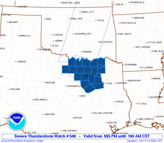
TXC085-097-113-119-121-139-147-181-213-223-231-237-257-277-337-
349-379-397-439-467-497-110700-
/O.NEW.KWNS.SV.A.0548.211110T2355Z-211111T0700Z/
TX
. TEXAS COUNTIES INCLUDED ARE
COLLIN COOKE DALLAS
DELTA DENTON ELLIS
FANNIN GRAYSON HENDERSON
HOPKINS HUNT JACK
KAUFMAN LAMAR MONTAGUE
NAVARRO RAINS ROCKWALL
TARRANT VAN ZANDT WISE
ATTN...WFO...FWD...
|
| Aviation Watch (SAW) for WW548 |
|---|
 |
| Note:
The Aviation Watch (SAW) product is an approximation to the watch area.
The actual watch is depicted by the shaded areas. |
   SAW8
   WW 548 SEVERE TSTM TX 102355Z - 110700Z
   AXIS..45 STATUTE MILES EITHER SIDE OF LINE..
   50NNW FTW/FORT WORTH TX/ - 70E DAL/DALLAS TX/
   ..AVIATION COORDS.. 40NM EITHER SIDE /50NW TTT - 52WNW GGG/
   HAIL SURFACE AND ALOFT..2.5 INCHES. WIND GUSTS..60 KNOTS.
   MAX TOPS TO 450. MEAN STORM MOTION VECTOR 30030.

   LAT...LON 34119746 33469540 32229588 32879794

   THIS IS AN APPROXIMATION TO THE WATCH AREA.  FOR A
   COMPLETE DEPICTION OF THE WATCH SEE WOUS64 KWNS
   FOR WOU8.
|
|


 @NWSSPC
