 Note:
The expiration time in the watch graphic is amended if the watch is
replaced, cancelled or extended.
Note:
Note:
The expiration time in the watch graphic is amended if the watch is
replaced, cancelled or extended.
Note: Click for
Watch Status Reports.
SEL9
URGENT - IMMEDIATE BROADCAST REQUESTED
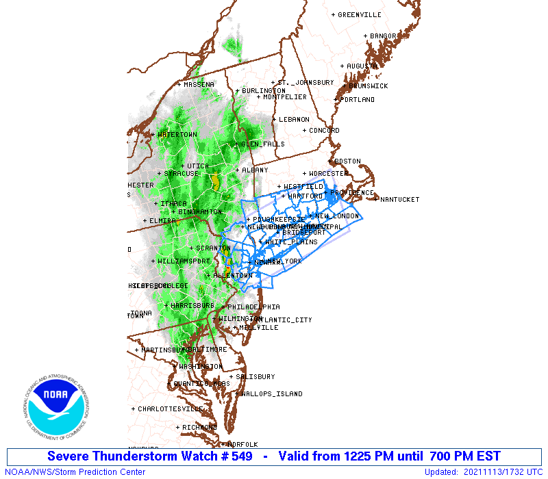
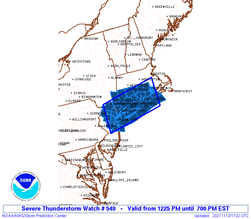
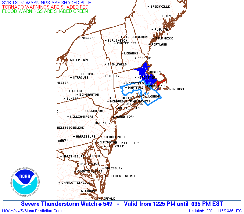
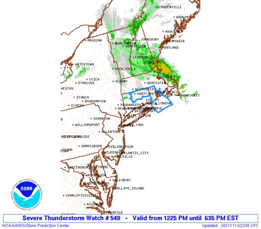
Severe Thunderstorm Watch Number 549
NWS Storm Prediction Center Norman OK
1225 PM EST Sat Nov 13 2021
The NWS Storm Prediction Center has issued a
* Severe Thunderstorm Watch for portions of
Connecticut
Northern New Jersey
Southeast New York
Rhode Island
Coastal Waters
* Effective this Saturday afternoon and evening from 1225 PM
until 700 PM EST.
* Primary threats include...
Scattered damaging winds likely with isolated significant gusts
to 75 mph possible
Isolated large hail events to 1 inch in diameter possible
A tornado or two possible
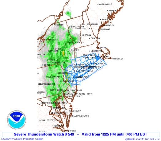
SUMMARY...An intensifying line of thunderstorms over northern New
Jersey will track eastward across the watch area this afternoon,
posing a risk of damaging wind gusts and isolated hail.
The severe thunderstorm watch area is approximately along and 50
statute miles north and south of a line from 25 miles west northwest
of Newark NJ to 25 miles southeast of Providence RI. For a complete
depiction of the watch see the associated watch outline update
(WOUS64 KWNS WOU9).
PRECAUTIONARY/PREPAREDNESS ACTIONS...
REMEMBER...A Severe Thunderstorm Watch means conditions are
favorable for severe thunderstorms in and close to the watch area.
Persons in these areas should be on the lookout for threatening
weather conditions and listen for later statements and possible
warnings. Severe thunderstorms can and occasionally do produce
tornadoes.
&&
AVIATION...A few severe thunderstorms with hail surface and aloft to
1 inch. Extreme turbulence and surface wind gusts to 65 knots. A few
cumulonimbi with maximum tops to 400. Mean storm motion vector
26035.
...Hart
   SEL9

   URGENT - IMMEDIATE BROADCAST REQUESTED
   Severe Thunderstorm Watch Number 549
   NWS Storm Prediction Center Norman OK
   1225 PM EST Sat Nov 13 2021

   The NWS Storm Prediction Center has issued a

   * Severe Thunderstorm Watch for portions of
     Connecticut
     Northern New Jersey
     Southeast New York
     Rhode Island
     Coastal Waters

   * Effective this Saturday afternoon and evening from 1225 PM
     until 700 PM EST.

   * Primary threats include...
     Scattered damaging winds likely with isolated significant gusts
       to 75 mph possible
     Isolated large hail events to 1 inch in diameter possible
     A tornado or two possible

   SUMMARY...An intensifying line of thunderstorms over northern New
   Jersey will track eastward across the watch area this afternoon,
   posing a risk of damaging wind gusts and isolated hail.

   The severe thunderstorm watch area is approximately along and 50
   statute miles north and south of a line from 25 miles west northwest
   of Newark NJ to 25 miles southeast of Providence RI. For a complete
   depiction of the watch see the associated watch outline update
   (WOUS64 KWNS WOU9).

   PRECAUTIONARY/PREPAREDNESS ACTIONS...

   REMEMBER...A Severe Thunderstorm Watch means conditions are
   favorable for severe thunderstorms in and close to the watch area.
   Persons in these areas should be on the lookout for threatening
   weather conditions and listen for later statements and possible
   warnings. Severe thunderstorms can and occasionally do produce
   tornadoes.

   &&

   AVIATION...A few severe thunderstorms with hail surface and aloft to
   1 inch. Extreme turbulence and surface wind gusts to 65 knots. A few
   cumulonimbi with maximum tops to 400. Mean storm motion vector
   26035.

   ...Hart
 Note:
The Aviation Watch (SAW) product is an approximation to the watch area.
The actual watch is depicted by the shaded areas.
Note:
The Aviation Watch (SAW) product is an approximation to the watch area.
The actual watch is depicted by the shaded areas.
   SAW9
   WW 549 SEVERE TSTM CT NJ NY RI CW 131725Z - 140000Z
   AXIS..50 STATUTE MILES NORTH AND SOUTH OF LINE..
   25WNW EWR/NEWARK NJ/ - 25SE PVD/PROVIDENCE RI/
   ..AVIATION COORDS.. 45NM N/S /14SSW SAX - 21SE PVD/
   HAIL SURFACE AND ALOFT..1 INCH. WIND GUSTS..65 KNOTS.
   MAX TOPS TO 400. MEAN STORM MOTION VECTOR 26035.

   LAT...LON 41567461 42207108 40757108 40117461

   THIS IS AN APPROXIMATION TO THE WATCH AREA.  FOR A
   COMPLETE DEPICTION OF THE WATCH SEE WOUS64 KWNS
   FOR WOU9.
Watch 549 Status Report Messages:
STATUS REPORT #7 ON WW 549

VALID 132215Z - 132340Z

SEVERE WEATHER THREAT CONTINUES RIGHT OF A LINE FROM 40 S BID TO
5 SW BID TO 20 WSW PVD TO 20 S ORH TO 15 W ORH.

..JEWELL..11/13/21

ATTN...WFO...OKX...BOX...ALY...PHI...

&&

STATUS REPORT FOR WS 549

SEVERE WEATHER THREAT CONTINUES FOR THE FOLLOWING AREAS

RIC001-003-005-007-009-132340-

RI
.    RHODE ISLAND COUNTIES INCLUDED ARE

BRISTOL 	     KENT		 NEWPORT
PROVIDENCE	     WASHINGTON
$$


ANZ235-236-237-256-132340-

CW

.    ADJACENT COASTAL WATERS INCLUDED ARE

RHODE ISLAND SOUND

NARRAGANSETT BAY

BLOCK ISLAND SOUND

COASTAL WATERS FROM MONTAUK NY TO MARTHAS VINEYARD EXTENDING OUT
TO 20 NM SOUTH OF BLOCK ISLAND

$$
THE WATCH STATUS MESSAGE IS FOR GUIDANCE PURPOSES ONLY.  PLEASE
REFER TO WATCH COUNTY NOTIFICATION STATEMENTS FOR OFFICIAL
INFORMATION ON COUNTIES...INDEPENDENT CITIES AND MARINE ZONES
CLEARED FROM SEVERE THUNDERSTORM AND TORNADO WATCHES.
$$

STATUS REPORT #6 ON WW 549

VALID 132130Z - 132240Z

SEVERE WEATHER THREAT CONTINUES RIGHT OF A LINE FROM 50 ESE ISP
TO 10 ENE BDL.

..KERR..11/13/21

ATTN...WFO...OKX...BOX...ALY...PHI...

&&

STATUS REPORT FOR WS 549

SEVERE WEATHER THREAT CONTINUES FOR THE FOLLOWING AREAS

CTC011-013-015-132240-

CT
.    CONNECTICUT COUNTIES INCLUDED ARE

NEW LONDON	     TOLLAND		 WINDHAM
$$


RIC001-003-005-007-009-132240-

RI
.    RHODE ISLAND COUNTIES INCLUDED ARE

BRISTOL 	     KENT		 NEWPORT
PROVIDENCE	     WASHINGTON
$$


ANZ235-236-237-256-332-350-132240-

CW

.    ADJACENT COASTAL WATERS INCLUDED ARE

RHODE ISLAND SOUND

NARRAGANSETT BAY

BLOCK ISLAND SOUND

COASTAL WATERS FROM MONTAUK NY TO MARTHAS VINEYARD EXTENDING OUT
TO 20 NM SOUTH OF BLOCK ISLAND

LONG ISLAND SOUND EAST OF THE MOUTH OF THE CONNECTICUT RIVER

MORICHES INLET NY TO MONTAUK POINT NY OUT 20 NM

$$
THE WATCH STATUS MESSAGE IS FOR GUIDANCE PURPOSES ONLY.  PLEASE
REFER TO WATCH COUNTY NOTIFICATION STATEMENTS FOR OFFICIAL
INFORMATION ON COUNTIES...INDEPENDENT CITIES AND MARINE ZONES
CLEARED FROM SEVERE THUNDERSTORM AND TORNADO WATCHES.
$$

STATUS REPORT #5 ON WW 549

VALID 132025Z - 132140Z

SEVERE WEATHER THREAT CONTINUES RIGHT OF A LINE FROM 30 SE JFK TO
15 WSW BDL.

..KERR..11/13/21

ATTN...WFO...OKX...BOX...ALY...PHI...

&&

STATUS REPORT FOR WS 549

SEVERE WEATHER THREAT CONTINUES FOR THE FOLLOWING AREAS

CTC003-007-009-011-013-015-132140-

CT
.    CONNECTICUT COUNTIES INCLUDED ARE

HARTFORD	     MIDDLESEX		 NEW HAVEN
NEW LONDON	     TOLLAND		 WINDHAM
$$


NYC103-132140-

NY
.    NEW YORK COUNTIES INCLUDED ARE

SUFFOLK
$$


RIC001-003-005-007-009-132140-

RI
.    RHODE ISLAND COUNTIES INCLUDED ARE

BRISTOL 	     KENT		 NEWPORT
PROVIDENCE	     WASHINGTON
$$


ANZ235-236-237-256-331-332-335-340-345-350-353-132140-

CW

.    ADJACENT COASTAL WATERS INCLUDED ARE

RHODE ISLAND SOUND

NARRAGANSETT BAY

BLOCK ISLAND SOUND

COASTAL WATERS FROM MONTAUK NY TO MARTHAS VINEYARD EXTENDING OUT
TO 20 NM SOUTH OF BLOCK ISLAND

LONG ISLAND SOUND EAST OF NEW HAVEN CT/PORT JEFFERSON NY TO THE
MOUTH OF THE CONNECTICUT RIVER

LONG ISLAND SOUND EAST OF THE MOUTH OF THE CONNECTICUT RIVER

LONG ISLAND SOUND WEST OF NEW HAVEN CT/PORT JEFFERSON NY

PECONIC AND GARDINERS BAYS

SOUTH SHORE BAYS FROM JONES INLET THROUGH SHINNECOCK BAY

MORICHES INLET NY TO MONTAUK POINT NY OUT 20 NM

FIRE ISLAND INLET NY TO MORICHES INLET NY OUT 20 NM

$$
THE WATCH STATUS MESSAGE IS FOR GUIDANCE PURPOSES ONLY.  PLEASE
REFER TO WATCH COUNTY NOTIFICATION STATEMENTS FOR OFFICIAL
INFORMATION ON COUNTIES...INDEPENDENT CITIES AND MARINE ZONES
CLEARED FROM SEVERE THUNDERSTORM AND TORNADO WATCHES.
$$

STATUS REPORT #4 ON WW 549

VALID 131955Z - 132040Z

SEVERE WEATHER THREAT CONTINUES RIGHT OF A LINE FROM 25 S JFK TO
35 WSW BDL.

..KERR..11/13/21

ATTN...WFO...OKX...BOX...ALY...PHI...

&&

STATUS REPORT FOR WS 549

SEVERE WEATHER THREAT CONTINUES FOR THE FOLLOWING AREAS

CTC001-003-005-007-009-011-013-015-132040-

CT
.    CONNECTICUT COUNTIES INCLUDED ARE

FAIRFIELD	     HARTFORD		 LITCHFIELD
MIDDLESEX	     NEW HAVEN		 NEW LONDON
TOLLAND 	     WINDHAM
$$


NYC059-103-132040-

NY
.    NEW YORK COUNTIES INCLUDED ARE

NASSAU		     SUFFOLK
$$


RIC001-003-005-007-009-132040-

RI
.    RHODE ISLAND COUNTIES INCLUDED ARE

BRISTOL 	     KENT		 NEWPORT
PROVIDENCE	     WASHINGTON
$$


ANZ235-236-237-256-331-332-335-340-345-350-353-355-450-132040-

CW

.    ADJACENT COASTAL WATERS INCLUDED ARE

RHODE ISLAND SOUND

NARRAGANSETT BAY

BLOCK ISLAND SOUND

COASTAL WATERS FROM MONTAUK NY TO MARTHAS VINEYARD EXTENDING OUT
TO 20 NM SOUTH OF BLOCK ISLAND

LONG ISLAND SOUND EAST OF NEW HAVEN CT/PORT JEFFERSON NY TO THE
MOUTH OF THE CONNECTICUT RIVER

LONG ISLAND SOUND EAST OF THE MOUTH OF THE CONNECTICUT RIVER

LONG ISLAND SOUND WEST OF NEW HAVEN CT/PORT JEFFERSON NY

PECONIC AND GARDINERS BAYS

SOUTH SHORE BAYS FROM JONES INLET THROUGH SHINNECOCK BAY

MORICHES INLET NY TO MONTAUK POINT NY OUT 20 NM

FIRE ISLAND INLET NY TO MORICHES INLET NY OUT 20 NM

SANDY HOOK NJ TO FIRE ISLAND INLET NY OUT 20 NM

COASTAL WATERS FROM SANDY HOOK TO MANASQUAN INLET NJ OUT 20 NM

$$
THE WATCH STATUS MESSAGE IS FOR GUIDANCE PURPOSES ONLY.  PLEASE
REFER TO WATCH COUNTY NOTIFICATION STATEMENTS FOR OFFICIAL
INFORMATION ON COUNTIES...INDEPENDENT CITIES AND MARINE ZONES
CLEARED FROM SEVERE THUNDERSTORM AND TORNADO WATCHES.
$$

STATUS REPORT #3 ON WW 549

VALID 131935Z - 132040Z

SEVERE WEATHER THREAT CONTINUES RIGHT OF A LINE FROM 20 NE NEL TO
20 ENE POU.

..KERR..11/13/21

ATTN...WFO...OKX...BOX...ALY...PHI...

&&

STATUS REPORT FOR WS 549

SEVERE WEATHER THREAT CONTINUES FOR THE FOLLOWING AREAS

CTC001-003-005-007-009-011-013-015-132040-

CT
.    CONNECTICUT COUNTIES INCLUDED ARE

FAIRFIELD	     HARTFORD		 LITCHFIELD
MIDDLESEX	     NEW HAVEN		 NEW LONDON
TOLLAND 	     WINDHAM
$$


NYC027-059-079-103-119-132040-

NY
.    NEW YORK COUNTIES INCLUDED ARE

DUTCHESS	     NASSAU		 PUTNAM
SUFFOLK 	     WESTCHESTER
$$


RIC001-003-005-007-009-132040-

RI
.    RHODE ISLAND COUNTIES INCLUDED ARE

BRISTOL 	     KENT		 NEWPORT
PROVIDENCE	     WASHINGTON
$$


ANZ235-236-237-256-331-332-335-340-345-350-353-355-450-132040-

CW

.    ADJACENT COASTAL WATERS INCLUDED ARE

RHODE ISLAND SOUND

NARRAGANSETT BAY

BLOCK ISLAND SOUND

COASTAL WATERS FROM MONTAUK NY TO MARTHAS VINEYARD EXTENDING OUT
TO 20 NM SOUTH OF BLOCK ISLAND

LONG ISLAND SOUND EAST OF NEW HAVEN CT/PORT JEFFERSON NY TO THE
MOUTH OF THE CONNECTICUT RIVER

LONG ISLAND SOUND EAST OF THE MOUTH OF THE CONNECTICUT RIVER

LONG ISLAND SOUND WEST OF NEW HAVEN CT/PORT JEFFERSON NY

PECONIC AND GARDINERS BAYS

SOUTH SHORE BAYS FROM JONES INLET THROUGH SHINNECOCK BAY

MORICHES INLET NY TO MONTAUK POINT NY OUT 20 NM

FIRE ISLAND INLET NY TO MORICHES INLET NY OUT 20 NM

SANDY HOOK NJ TO FIRE ISLAND INLET NY OUT 20 NM

COASTAL WATERS FROM SANDY HOOK TO MANASQUAN INLET NJ OUT 20 NM

$$
THE WATCH STATUS MESSAGE IS FOR GUIDANCE PURPOSES ONLY.  PLEASE
REFER TO WATCH COUNTY NOTIFICATION STATEMENTS FOR OFFICIAL
INFORMATION ON COUNTIES...INDEPENDENT CITIES AND MARINE ZONES
CLEARED FROM SEVERE THUNDERSTORM AND TORNADO WATCHES.
$$

STATUS REPORT #2 ON WW 549

VALID 131925Z - 132040Z

SEVERE WEATHER THREAT CONTINUES RIGHT OF A LINE FROM 20 NE NEL TO
15 ENE POU.

..KERR..11/13/21

ATTN...WFO...OKX...BOX...ALY...PHI...

&&

STATUS REPORT FOR WS 549

SEVERE WEATHER THREAT CONTINUES FOR THE FOLLOWING AREAS

CTC001-003-005-007-009-011-013-015-132040-

CT
.    CONNECTICUT COUNTIES INCLUDED ARE

FAIRFIELD	     HARTFORD		 LITCHFIELD
MIDDLESEX	     NEW HAVEN		 NEW LONDON
TOLLAND 	     WINDHAM
$$


NJC025-132040-

NJ
.    NEW JERSEY COUNTIES INCLUDED ARE

MONMOUTH
$$


NYC027-059-079-103-119-132040-

NY
.    NEW YORK COUNTIES INCLUDED ARE

DUTCHESS	     NASSAU		 PUTNAM
SUFFOLK 	     WESTCHESTER
$$


RIC001-003-005-007-009-132040-

RI
.    RHODE ISLAND COUNTIES INCLUDED ARE

BRISTOL 	     KENT		 NEWPORT
PROVIDENCE	     WASHINGTON
$$


ANZ235-236-237-256-331-332-335-340-345-350-353-355-450-132040-

CW

.    ADJACENT COASTAL WATERS INCLUDED ARE

RHODE ISLAND SOUND

NARRAGANSETT BAY

BLOCK ISLAND SOUND

COASTAL WATERS FROM MONTAUK NY TO MARTHAS VINEYARD EXTENDING OUT
TO 20 NM SOUTH OF BLOCK ISLAND

LONG ISLAND SOUND EAST OF NEW HAVEN CT/PORT JEFFERSON NY TO THE
MOUTH OF THE CONNECTICUT RIVER

LONG ISLAND SOUND EAST OF THE MOUTH OF THE CONNECTICUT RIVER

LONG ISLAND SOUND WEST OF NEW HAVEN CT/PORT JEFFERSON NY

PECONIC AND GARDINERS BAYS

SOUTH SHORE BAYS FROM JONES INLET THROUGH SHINNECOCK BAY

MORICHES INLET NY TO MONTAUK POINT NY OUT 20 NM

FIRE ISLAND INLET NY TO MORICHES INLET NY OUT 20 NM

SANDY HOOK NJ TO FIRE ISLAND INLET NY OUT 20 NM

COASTAL WATERS FROM SANDY HOOK TO MANASQUAN INLET NJ OUT 20 NM

$$
THE WATCH STATUS MESSAGE IS FOR GUIDANCE PURPOSES ONLY.  PLEASE
REFER TO WATCH COUNTY NOTIFICATION STATEMENTS FOR OFFICIAL
INFORMATION ON COUNTIES...INDEPENDENT CITIES AND MARINE ZONES
CLEARED FROM SEVERE THUNDERSTORM AND TORNADO WATCHES.
$$

STATUS REPORT #1 ON WW 549

VALID 131835Z - 131940Z

SEVERE WEATHER THREAT CONTINUES RIGHT OF A LINE FROM 15 WNW NEL
TO 10 W POU.

..KERR..11/13/21

ATTN...WFO...OKX...BOX...ALY...PHI...

&&

STATUS REPORT FOR WS 549

SEVERE WEATHER THREAT CONTINUES FOR THE FOLLOWING AREAS

CTC001-003-005-007-009-011-013-015-131940-

CT
.    CONNECTICUT COUNTIES INCLUDED ARE

FAIRFIELD	     HARTFORD		 LITCHFIELD
MIDDLESEX	     NEW HAVEN		 NEW LONDON
TOLLAND 	     WINDHAM
$$


NJC003-013-017-023-025-039-131940-

NJ
.    NEW JERSEY COUNTIES INCLUDED ARE

BERGEN		     ESSEX		 HUDSON
MIDDLESEX	     MONMOUTH		 UNION
$$


NYC005-027-047-059-061-071-079-081-085-087-103-119-131940-

NY
.    NEW YORK COUNTIES INCLUDED ARE

BRONX		     DUTCHESS		 KINGS
NASSAU		     NEW YORK		 ORANGE
PUTNAM		     QUEENS		 RICHMOND
ROCKLAND	     SUFFOLK		 WESTCHESTER
$$


RIC001-003-005-007-009-131940-

RI
.    RHODE ISLAND COUNTIES INCLUDED ARE

BRISTOL 	     KENT		 NEWPORT
PROVIDENCE	     WASHINGTON
$$


ANZ235-236-237-256-331-332-335-338-340-345-350-353-355-450-
131940-

CW

.    ADJACENT COASTAL WATERS INCLUDED ARE

RHODE ISLAND SOUND

NARRAGANSETT BAY

BLOCK ISLAND SOUND

COASTAL WATERS FROM MONTAUK NY TO MARTHAS VINEYARD EXTENDING OUT
TO 20 NM SOUTH OF BLOCK ISLAND

LONG ISLAND SOUND EAST OF NEW HAVEN CT/PORT JEFFERSON NY TO THE
MOUTH OF THE CONNECTICUT RIVER

LONG ISLAND SOUND EAST OF THE MOUTH OF THE CONNECTICUT RIVER

LONG ISLAND SOUND WEST OF NEW HAVEN CT/PORT JEFFERSON NY

NEW YORK HARBOR

PECONIC AND GARDINERS BAYS

SOUTH SHORE BAYS FROM JONES INLET THROUGH SHINNECOCK BAY

MORICHES INLET NY TO MONTAUK POINT NY OUT 20 NM

FIRE ISLAND INLET NY TO MORICHES INLET NY OUT 20 NM

SANDY HOOK NJ TO FIRE ISLAND INLET NY OUT 20 NM

COASTAL WATERS FROM SANDY HOOK TO MANASQUAN INLET NJ OUT 20 NM

$$
THE WATCH STATUS MESSAGE IS FOR GUIDANCE PURPOSES ONLY.  PLEASE
REFER TO WATCH COUNTY NOTIFICATION STATEMENTS FOR OFFICIAL
INFORMATION ON COUNTIES...INDEPENDENT CITIES AND MARINE ZONES
CLEARED FROM SEVERE THUNDERSTORM AND TORNADO WATCHES.
$$
Note:
Click for Complete Product Text.
Tornadoes
Probability of 2 or more tornadoes
|
Low (20%)
|
Probability of 1 or more strong (EF2-EF5) tornadoes
|
Low (<2%)
|
Wind
Probability of 10 or more severe wind events
|
Mod (60%)
|
Probability of 1 or more wind events > 65 knots
|
Mod (30%)
|
Hail
Probability of 10 or more severe hail events
|
Low (20%)
|
Probability of 1 or more hailstones > 2 inches
|
Low (10%)
|
Combined Severe Hail/Wind
Probability of 6 or more combined severe hail/wind events
|
High (90%)
|
For each watch, probabilities for particular events inside the watch
(listed above in each table) are determined by the issuing forecaster.
The "Low" category contains probability values ranging from less than 2%
to 20% (EF2-EF5 tornadoes), less than 5% to 20% (all other probabilities),
"Moderate" from 30% to 60%, and "High" from 70% to greater than 95%.
High values are bolded and lighter in color to provide awareness of
an increased threat for a particular event.


 @NWSSPC