 Note:
The expiration time in the watch graphic is amended if the watch is
replaced, cancelled or extended.
Note:
Note:
The expiration time in the watch graphic is amended if the watch is
replaced, cancelled or extended.
Note: Click for
Watch Status Reports.
SEL7
URGENT - IMMEDIATE BROADCAST REQUESTED
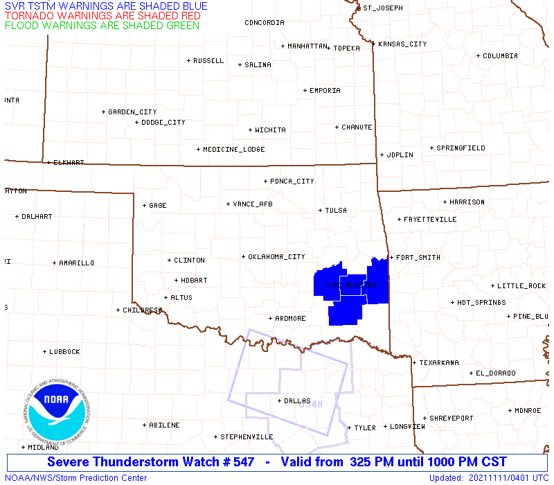
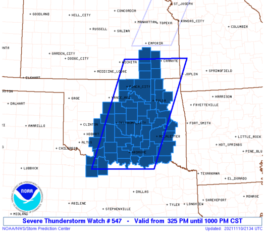
Severe Thunderstorm Watch Number 547
NWS Storm Prediction Center Norman OK
325 PM CST Wed Nov 10 2021
The NWS Storm Prediction Center has issued a
* Severe Thunderstorm Watch for portions of
Southeast Kansas
Central and Eastern Oklahoma
Western North Texas
* Effective this Wednesday afternoon and evening from 325 PM
until 1000 PM CST.
* Primary threats include...
Scattered large hail likely with isolated very large hail events
to 2 inches in diameter possible
Scattered damaging wind gusts to 70 mph likely
A tornado or two possible
SUMMARY...Severe thunderstorms are expected to develop through late
afternoon initially across central Oklahoma into southeast Kansas,
with additional development and general eastward movement of these
storms into western North Texas and eastern Oklahoma by
early/mid-evening.
The severe thunderstorm watch area is approximately along and 80
statute miles east and west of a line from 15 miles west northwest
of Chanute KS to 45 miles south southwest of Ardmore OK. For a
complete depiction of the watch see the associated watch outline
update (WOUS64 KWNS WOU7).
PRECAUTIONARY/PREPAREDNESS ACTIONS...
REMEMBER...A Severe Thunderstorm Watch means conditions are
favorable for severe thunderstorms in and close to the watch area.
Persons in these areas should be on the lookout for threatening
weather conditions and listen for later statements and possible
warnings. Severe thunderstorms can and occasionally do produce
tornadoes.
&&
OTHER WATCH INFORMATION...CONTINUE...WW 546...
AVIATION...A few severe thunderstorms with hail surface and aloft to
2 inches. Extreme turbulence and surface wind gusts to 60 knots. A
few cumulonimbi with maximum tops to 450. Mean storm motion vector
25025.
...Guyer
   SEL7

   URGENT - IMMEDIATE BROADCAST REQUESTED
   Severe Thunderstorm Watch Number 547
   NWS Storm Prediction Center Norman OK
   325 PM CST Wed Nov 10 2021

   The NWS Storm Prediction Center has issued a

   * Severe Thunderstorm Watch for portions of
     Southeast Kansas
     Central and Eastern Oklahoma
     Western North Texas

   * Effective this Wednesday afternoon and evening from 325 PM
     until 1000 PM CST.

   * Primary threats include...
     Scattered large hail likely with isolated very large hail events
       to 2 inches in diameter possible
     Scattered damaging wind gusts to 70 mph likely
     A tornado or two possible

   SUMMARY...Severe thunderstorms are expected to develop through late
   afternoon initially across central Oklahoma into southeast Kansas,
   with additional development and general eastward movement of these
   storms into western North Texas and eastern Oklahoma by
   early/mid-evening.

   The severe thunderstorm watch area is approximately along and 80
   statute miles east and west of a line from 15 miles west northwest
   of Chanute KS to 45 miles south southwest of Ardmore OK. For a
   complete depiction of the watch see the associated watch outline
   update (WOUS64 KWNS WOU7).

   PRECAUTIONARY/PREPAREDNESS ACTIONS...

   REMEMBER...A Severe Thunderstorm Watch means conditions are
   favorable for severe thunderstorms in and close to the watch area.
   Persons in these areas should be on the lookout for threatening
   weather conditions and listen for later statements and possible
   warnings. Severe thunderstorms can and occasionally do produce
   tornadoes.

   &&

   OTHER WATCH INFORMATION...CONTINUE...WW 546...

   AVIATION...A few severe thunderstorms with hail surface and aloft to
   2 inches. Extreme turbulence and surface wind gusts to 60 knots. A
   few cumulonimbi with maximum tops to 450. Mean storm motion vector
   25025.

   ...Guyer
 Note:
The Aviation Watch (SAW) product is an approximation to the watch area.
The actual watch is depicted by the shaded areas.
Note:
The Aviation Watch (SAW) product is an approximation to the watch area.
The actual watch is depicted by the shaded areas.
   SAW7
   WW 547 SEVERE TSTM KS OK TX 102125Z - 110400Z
   AXIS..80 STATUTE MILES EAST AND WEST OF LINE..
   15WNW CNU/CHANUTE KS/ - 45SSW ADM/ARDMORE OK/
   ..AVIATION COORDS.. 70NM E/W /44NW OSW - 32SSW ADM/
   HAIL SURFACE AND ALOFT..2 INCHES. WIND GUSTS..60 KNOTS.
   MAX TOPS TO 450. MEAN STORM MOTION VECTOR 25025.

   LAT...LON 37749427 33689593 33689871 37749720

   THIS IS AN APPROXIMATION TO THE WATCH AREA.  FOR A
   COMPLETE DEPICTION OF THE WATCH SEE WOUS64 KWNS
   FOR WOU7.
Watch 547 Status Report Messages:
STATUS REPORT #4 ON WW 547

VALID 110305Z - 110400Z

SEVERE WEATHER THREAT CONTINUES RIGHT OF A LINE FROM 20 WNW GYI
TO 10 SSE ADM TO 35 NNE ADM TO 40 WSW MKO TO 25 WNW MKO TO 35 NE
MKO TO 10 NNW GMJ TO 45 ENE CNU.

WW 547 WILL BE ALLOWED TO EXPIRE AT 110400Z.

..JEWELL..11/11/21

ATTN...WFO...ICT...OUN...TSA...

&&

STATUS REPORT FOR WS 547

SEVERE WEATHER THREAT CONTINUES FOR THE FOLLOWING AREAS

ARC007-033-131-143-110400-

AR
.    ARKANSAS COUNTIES INCLUDED ARE

BENTON		     CRAWFORD		 SEBASTIAN
WASHINGTON
$$


OKC001-005-013-021-023-029-041-061-063-069-077-079-091-095-101-
115-121-123-127-135-110400-

OK
.    OKLAHOMA COUNTIES INCLUDED ARE

ADAIR		     ATOKA		 BRYAN
CHEROKEE	     CHOCTAW		 COAL
DELAWARE	     HASKELL		 HUGHES
JOHNSTON	     LATIMER		 LE FLORE
MCINTOSH	     MARSHALL		 MUSKOGEE
OTTAWA		     PITTSBURG		 PONTOTOC
PUSHMATAHA	     SEQUOYAH
$$


THE WATCH STATUS MESSAGE IS FOR GUIDANCE PURPOSES ONLY.  PLEASE
REFER TO WATCH COUNTY NOTIFICATION STATEMENTS FOR OFFICIAL
INFORMATION ON COUNTIES...INDEPENDENT CITIES AND MARINE ZONES
CLEARED FROM SEVERE THUNDERSTORM AND TORNADO WATCHES.
$$

STATUS REPORT #3 ON WW 547

VALID 110305Z - 110400Z

SEVERE WEATHER THREAT CONTINUES RIGHT OF A LINE FROM 20 WNW GYI
TO 10 SSE ADM TO 35 NNE ADM TO 40 WSW MKO TO 25 WNW MKO TO 35 NE
MKO TO 10 NNW GMJ TO 45 ENE CNU.

WW 547 WILL BE ALLOWED TO EXPIRE AT 110400Z.

..JEWELL..11/11/21

ATTN...WFO...ICT...OUN...TSA...

&&

STATUS REPORT FOR WS 547

SEVERE WEATHER THREAT CONTINUES FOR THE FOLLOWING AREAS

ARC007-033-131-143-110400-

AR
.    ARKANSAS COUNTIES INCLUDED ARE

BENTON		     CRAWFORD		 SEBASTIAN
WASHINGTON
$$


OKC001-005-013-021-023-029-041-061-063-069-077-079-091-095-101-
115-121-123-127-135-110400-

OK
.    OKLAHOMA COUNTIES INCLUDED ARE

ADAIR		     ATOKA		 BRYAN
CHEROKEE	     CHOCTAW		 COAL
DELAWARE	     HASKELL		 HUGHES
JOHNSTON	     LATIMER		 LE FLORE
MCINTOSH	     MARSHALL		 MUSKOGEE
OTTAWA		     PITTSBURG		 PONTOTOC
PUSHMATAHA	     SEQUOYAH
$$


THE WATCH STATUS MESSAGE IS FOR GUIDANCE PURPOSES ONLY.  PLEASE
REFER TO WATCH COUNTY NOTIFICATION STATEMENTS FOR OFFICIAL
INFORMATION ON COUNTIES...INDEPENDENT CITIES AND MARINE ZONES
CLEARED FROM SEVERE THUNDERSTORM AND TORNADO WATCHES.
$$

STATUS REPORT #2 ON WW 547

VALID 110055Z - 110140Z

SEVERE WEATHER THREAT CONTINUES RIGHT OF A LINE FROM 35 WSW SPS
TO 10 SSW SPS TO 30 NE SPS TO 5 S OKC TO 35 S PNC TO 40 NW BVO TO
25 S EMP TO 15 ESE EMP.

..JEWELL..11/11/21

ATTN...WFO...ICT...OUN...TSA...

&&

STATUS REPORT FOR WS 547

SEVERE WEATHER THREAT CONTINUES FOR THE FOLLOWING AREAS

KSC019-049-073-125-205-207-110140-

KS
.    KANSAS COUNTIES INCLUDED ARE

CHAUTAUQUA	     ELK		 GREENWOOD
MONTGOMERY	     WILSON		 WOODSON
$$


OKC005-013-019-023-027-029-037-049-051-061-063-067-069-077-081-
085-087-091-095-097-099-101-105-107-109-111-113-117-119-121-123-
125-127-131-133-137-143-145-147-110140-

OK
.    OKLAHOMA COUNTIES INCLUDED ARE

ATOKA		     BRYAN		 CARTER
CHOCTAW 	     CLEVELAND		 COAL
CREEK		     GARVIN		 GRADY
HASKELL 	     HUGHES		 JEFFERSON
JOHNSTON	     LATIMER		 LINCOLN
LOVE		     MCCLAIN		 MCINTOSH
MARSHALL	     MAYES		 MURRAY
MUSKOGEE	     NOWATA		 OKFUSKEE
OKLAHOMA	     OKMULGEE		 OSAGE
PAWNEE		     PAYNE		 PITTSBURG
PONTOTOC	     POTTAWATOMIE	 PUSHMATAHA
ROGERS		     SEMINOLE		 STEPHENS
TULSA		     WAGONER		 WASHINGTON
$$


TXC009-077-110140-

TX
.    TEXAS COUNTIES INCLUDED ARE

ARCHER		     CLAY
$$


THE WATCH STATUS MESSAGE IS FOR GUIDANCE PURPOSES ONLY.  PLEASE
REFER TO WATCH COUNTY NOTIFICATION STATEMENTS FOR OFFICIAL
INFORMATION ON COUNTIES...INDEPENDENT CITIES AND MARINE ZONES
CLEARED FROM SEVERE THUNDERSTORM AND TORNADO WATCHES.
$$

STATUS REPORT #1 ON WW 547

VALID 102320Z - 110040Z

THE SEVERE WEATHER THREAT CONTINUES ACROSS THE ENTIRE WATCH AREA.

..JEWELL..11/10/21

ATTN...WFO...ICT...OUN...TSA...

&&

STATUS REPORT FOR WS 547

SEVERE WEATHER THREAT CONTINUES FOR THE FOLLOWING AREAS

KSC019-049-073-125-205-207-110040-

KS
.    KANSAS COUNTIES INCLUDED ARE

CHAUTAUQUA	     ELK		 GREENWOOD
MONTGOMERY	     WILSON		 WOODSON
$$


OKC005-013-015-017-019-023-027-029-031-033-037-049-051-061-063-
067-069-071-073-077-081-083-085-087-091-095-097-099-101-103-105-
107-109-111-113-117-119-121-123-125-127-131-133-137-143-145-147-
110040-

OK
.    OKLAHOMA COUNTIES INCLUDED ARE

ATOKA		     BRYAN		 CADDO
CANADIAN	     CARTER		 CHOCTAW
CLEVELAND	     COAL		 COMANCHE
COTTON		     CREEK		 GARVIN
GRADY		     HASKELL		 HUGHES
JEFFERSON	     JOHNSTON		 KAY
KINGFISHER	     LATIMER		 LINCOLN
LOGAN		     LOVE		 MCCLAIN
MCINTOSH	     MARSHALL		 MAYES
MURRAY		     MUSKOGEE		 NOBLE
NOWATA		     OKFUSKEE		 OKLAHOMA
OKMULGEE	     OSAGE		 PAWNEE
PAYNE		     PITTSBURG		 PONTOTOC
POTTAWATOMIE	     PUSHMATAHA 	 ROGERS
SEMINOLE	     STEPHENS		 TULSA
WAGONER 	     WASHINGTON
$$


TXC009-077-485-110040-

TX
.    TEXAS COUNTIES INCLUDED ARE

ARCHER		     CLAY		 WICHITA
$$


THE WATCH STATUS MESSAGE IS FOR GUIDANCE PURPOSES ONLY.  PLEASE
REFER TO WATCH COUNTY NOTIFICATION STATEMENTS FOR OFFICIAL
INFORMATION ON COUNTIES...INDEPENDENT CITIES AND MARINE ZONES
CLEARED FROM SEVERE THUNDERSTORM AND TORNADO WATCHES.
$$
Note:
Click for Complete Product Text.
Tornadoes
Probability of 2 or more tornadoes
|
Low (20%)
|
Probability of 1 or more strong (EF2-EF5) tornadoes
|
Low (10%)
|
Wind
Probability of 10 or more severe wind events
|
Mod (60%)
|
Probability of 1 or more wind events > 65 knots
|
Low (20%)
|
Hail
Probability of 10 or more severe hail events
|
Mod (60%)
|
Probability of 1 or more hailstones > 2 inches
|
Mod (50%)
|
Combined Severe Hail/Wind
Probability of 6 or more combined severe hail/wind events
|
High (>95%)
|
For each watch, probabilities for particular events inside the watch
(listed above in each table) are determined by the issuing forecaster.
The "Low" category contains probability values ranging from less than 2%
to 20% (EF2-EF5 tornadoes), less than 5% to 20% (all other probabilities),
"Moderate" from 30% to 60%, and "High" from 70% to greater than 95%.
High values are bolded and lighter in color to provide awareness of
an increased threat for a particular event.


 @NWSSPC