 Note:
The expiration time in the watch graphic is amended if the watch is
replaced, cancelled or extended.
Note:
Note:
The expiration time in the watch graphic is amended if the watch is
replaced, cancelled or extended.
Note: Click for
Watch Status Reports.
SEL8
URGENT - IMMEDIATE BROADCAST REQUESTED
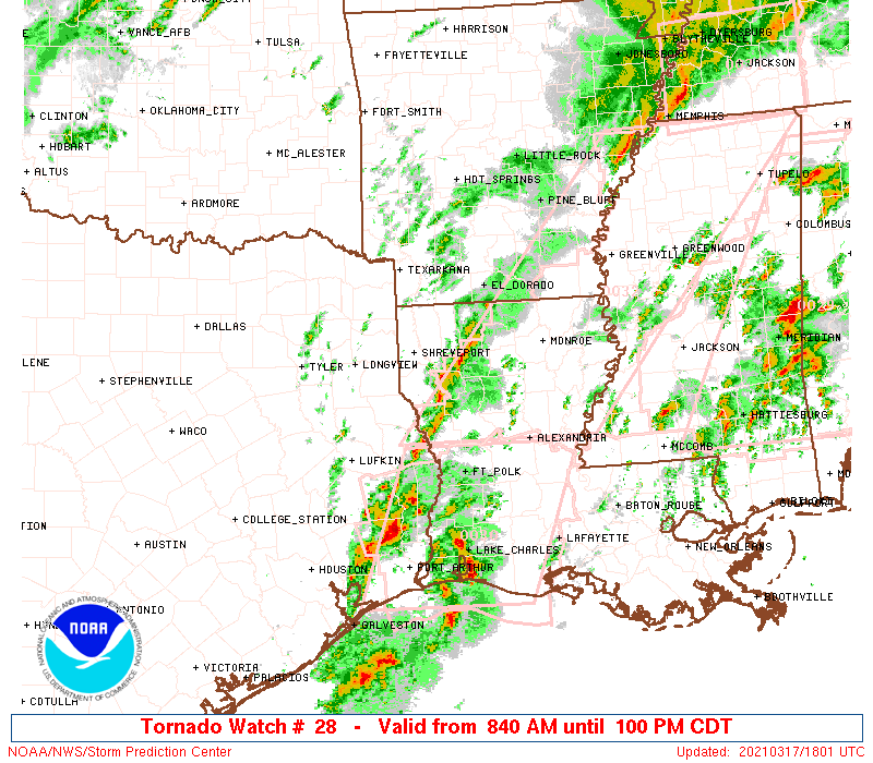
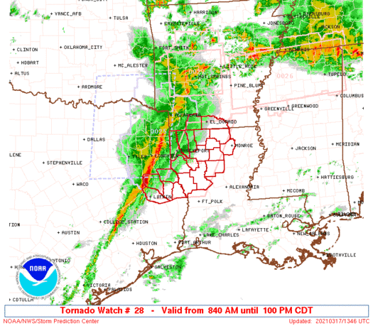
Tornado Watch Number 28
NWS Storm Prediction Center Norman OK
840 AM CDT Wed Mar 17 2021
The NWS Storm Prediction Center has issued a
* Tornado Watch for portions of
Southwest Arkansas
Northwest Louisiana
Far eastern Texas
* Effective this Wednesday morning and afternoon from 840 AM
until 100 PM CDT.
* Primary threats include...
A few tornadoes possible
Scattered damaging winds likely with isolated significant gusts
to 75 mph possible
Isolated large hail events to 1.5 inches in diameter possible
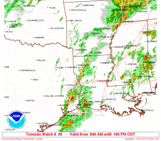
SUMMARY...A squall line across eastern TX should continue east
across parts of the Sabine Valley into Louisiana and southern
Arkansas through midday. Damaging wind gusts will be the main hazard
initially, but the tornado risk should increase later this morning.
The tornado watch area is approximately along and 45 statute miles
east and west of a line from 10 miles east of El Dorado AR to 55
miles southwest of Natchitoches LA. For a complete depiction of the
watch see the associated watch outline update (WOUS64 KWNS WOU8).
PRECAUTIONARY/PREPAREDNESS ACTIONS...
REMEMBER...A Tornado Watch means conditions are favorable for
tornadoes and severe thunderstorms in and close to the watch
area. Persons in these areas should be on the lookout for
threatening weather conditions and listen for later statements
and possible warnings.
&&
OTHER WATCH INFORMATION...CONTINUE...WW 25...WW 26...WW 27...
AVIATION...Tornadoes and a few severe thunderstorms with hail
surface and aloft to 1.5 inches. Extreme turbulence and surface wind
gusts to 65 knots. A few cumulonimbi with maximum tops to 500. Mean
storm motion vector 26035.
...Grams
   SEL8

   URGENT - IMMEDIATE BROADCAST REQUESTED
   Tornado Watch Number 28
   NWS Storm Prediction Center Norman OK
   840 AM CDT Wed Mar 17 2021

   The NWS Storm Prediction Center has issued a

   * Tornado Watch for portions of
     Southwest Arkansas
     Northwest Louisiana
     Far eastern Texas

   * Effective this Wednesday morning and afternoon from 840 AM
     until 100 PM CDT.

   * Primary threats include...
     A few tornadoes possible
     Scattered damaging winds likely with isolated significant gusts
       to 75 mph possible
     Isolated large hail events to 1.5 inches in diameter possible

   SUMMARY...A squall line across eastern TX should continue east
   across parts of the Sabine Valley into Louisiana and southern
   Arkansas through midday. Damaging wind gusts will be the main hazard
   initially, but the tornado risk should increase later this morning.

   The tornado watch area is approximately along and 45 statute miles
   east and west of a line from 10 miles east of El Dorado AR to 55
   miles southwest of Natchitoches LA. For a complete depiction of the
   watch see the associated watch outline update (WOUS64 KWNS WOU8).

   PRECAUTIONARY/PREPAREDNESS ACTIONS...

   REMEMBER...A Tornado Watch means conditions are favorable for
   tornadoes and severe thunderstorms in and close to the watch
   area. Persons in these areas should be on the lookout for
   threatening weather conditions and listen for later statements
   and possible warnings.

   &&

   OTHER WATCH INFORMATION...CONTINUE...WW 25...WW 26...WW 27...

   AVIATION...Tornadoes and a few severe thunderstorms with hail
   surface and aloft to 1.5 inches. Extreme turbulence and surface wind
   gusts to 65 knots. A few cumulonimbi with maximum tops to 500. Mean
   storm motion vector 26035.

   ...Grams
 Note:
The Aviation Watch (SAW) product is an approximation to the watch area.
The actual watch is depicted by the shaded areas.
Note:
The Aviation Watch (SAW) product is an approximation to the watch area.
The actual watch is depicted by the shaded areas.
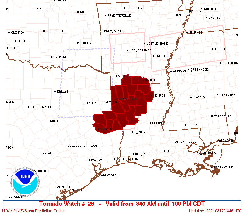
   SAW8
   WW 28 TORNADO AR LA TX 171340Z - 171800Z
   AXIS..45 STATUTE MILES EAST AND WEST OF LINE..
   10E ELD/EL DORADO AR/ - 55SW IER/NATCHITOCHES LA/
   ..AVIATION COORDS.. 40NM E/W /5ESE ELD - 49E LFK/
   HAIL SURFACE AND ALOFT..1.5 INCHES. WIND GUSTS..65 KNOTS.
   MAX TOPS TO 500. MEAN STORM MOTION VECTOR 26035.

   LAT...LON 33229187 31179300 31179452 33229343

   THIS IS AN APPROXIMATION TO THE WATCH AREA.  FOR A
   COMPLETE DEPICTION OF THE WATCH SEE WOUS64 KWNS
   FOR WOU8.
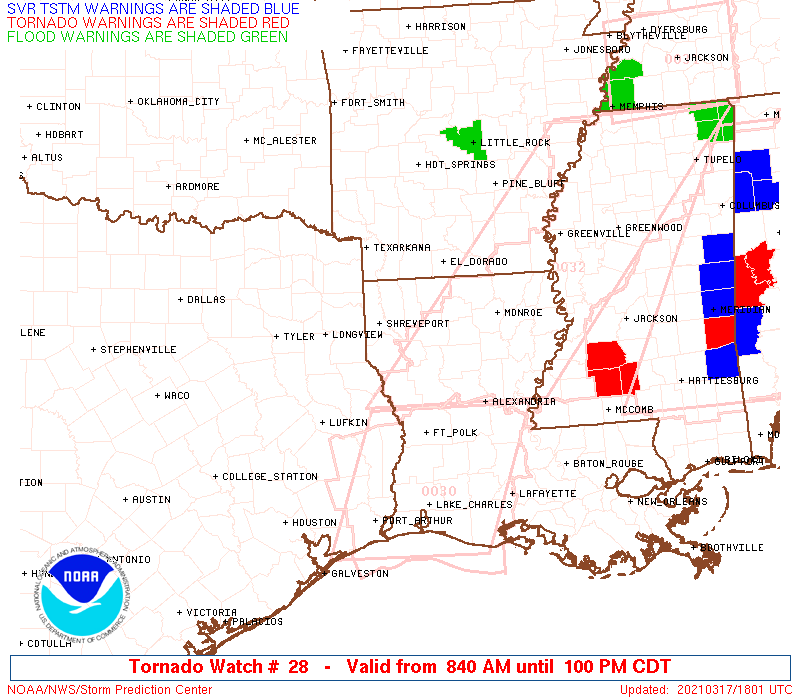
Watch 28 Status Report Messages:
STATUS REPORT #3 ON WW 28

VALID 171740Z - 171840Z

SEVERE WEATHER THREAT CONTINUES RIGHT OF A LINE FROM 25 SE LFK TO
40 ENE LFK TO 25 SSE SHV TO 30 ENE SHV TO 20 SW ELD TO 15 NNE ELD.

..BENTLEY..03/17/21

ATTN...WFO...SHV...

&&

STATUS REPORT FOR WT 28

SEVERE WEATHER THREAT CONTINUES FOR THE FOLLOWING AREAS

ARC139-171840-

AR
.    ARKANSAS COUNTIES INCLUDED ARE

UNION
$$


LAC013-027-031-049-061-069-073-081-085-111-127-171840-

LA
.    LOUISIANA PARISHES INCLUDED ARE

BIENVILLE	     CLAIBORNE		 DE SOTO
JACKSON 	     LINCOLN		 NATCHITOCHES
OUACHITA	     RED RIVER		 SABINE
UNION		     WINN
$$


TXC403-405-171840-

TX
.    TEXAS COUNTIES INCLUDED ARE

SABINE		     SAN AUGUSTINE
$$


THE WATCH STATUS MESSAGE IS FOR GUIDANCE PURPOSES ONLY.  PLEASE
REFER TO WATCH COUNTY NOTIFICATION STATEMENTS FOR OFFICIAL
INFORMATION ON COUNTIES...INDEPENDENT CITIES AND MARINE ZONES
CLEARED FROM SEVERE THUNDERSTORM AND TORNADO WATCHES.
$$

STATUS REPORT #2 ON WW 28

VALID 171645Z - 171740Z

THE SEVERE WEATHER THREAT CONTINUES ACROSS THE ENTIRE WATCH AREA.

FOR ADDITIONAL INFORMATION SEE MESOSCALE DISCUSSION 201

..BENTLEY..03/17/21

ATTN...WFO...SHV...

&&

STATUS REPORT FOR WT 28

SEVERE WEATHER THREAT CONTINUES FOR THE FOLLOWING AREAS

ARC027-139-171740-

AR
.    ARKANSAS COUNTIES INCLUDED ARE

COLUMBIA	     UNION
$$


LAC013-015-017-027-031-049-061-069-073-081-085-111-119-127-
171740-

LA
.    LOUISIANA PARISHES INCLUDED ARE

BIENVILLE	     BOSSIER		 CADDO
CLAIBORNE	     DE SOTO		 JACKSON
LINCOLN 	     NATCHITOCHES	 OUACHITA
RED RIVER	     SABINE		 UNION
WEBSTER 	     WINN
$$


TXC005-347-403-405-419-171740-

TX
.    TEXAS COUNTIES INCLUDED ARE

ANGELINA	     NACOGDOCHES	 SABINE
SAN AUGUSTINE	     SHELBY
$$


THE WATCH STATUS MESSAGE IS FOR GUIDANCE PURPOSES ONLY.  PLEASE
REFER TO WATCH COUNTY NOTIFICATION STATEMENTS FOR OFFICIAL
INFORMATION ON COUNTIES...INDEPENDENT CITIES AND MARINE ZONES
CLEARED FROM SEVERE THUNDERSTORM AND TORNADO WATCHES.
$$

STATUS REPORT #1 ON WW 28

VALID 171505Z - 171640Z

THE SEVERE WEATHER THREAT CONTINUES ACROSS THE ENTIRE WATCH AREA.

..MOSIER..03/17/21

ATTN...WFO...SHV...

&&

STATUS REPORT FOR WT 28

SEVERE WEATHER THREAT CONTINUES FOR THE FOLLOWING AREAS

ARC027-139-171640-

AR
.    ARKANSAS COUNTIES INCLUDED ARE

COLUMBIA	     UNION
$$


LAC013-015-017-027-031-049-061-069-073-081-085-111-119-127-
171640-

LA
.    LOUISIANA PARISHES INCLUDED ARE

BIENVILLE	     BOSSIER		 CADDO
CLAIBORNE	     DE SOTO		 JACKSON
LINCOLN 	     NATCHITOCHES	 OUACHITA
RED RIVER	     SABINE		 UNION
WEBSTER 	     WINN
$$


TXC005-347-403-405-419-171640-

TX
.    TEXAS COUNTIES INCLUDED ARE

ANGELINA	     NACOGDOCHES	 SABINE
SAN AUGUSTINE	     SHELBY
$$


THE WATCH STATUS MESSAGE IS FOR GUIDANCE PURPOSES ONLY.  PLEASE
REFER TO WATCH COUNTY NOTIFICATION STATEMENTS FOR OFFICIAL
INFORMATION ON COUNTIES...INDEPENDENT CITIES AND MARINE ZONES
CLEARED FROM SEVERE THUNDERSTORM AND TORNADO WATCHES.
$$
Note:
Click for Complete Product Text.
Tornadoes
Probability of 2 or more tornadoes
|
Mod (50%)
|
Probability of 1 or more strong (EF2-EF5) tornadoes
|
Low (20%)
|
Wind
Probability of 10 or more severe wind events
|
High (70%)
|
Probability of 1 or more wind events > 65 knots
|
Mod (40%)
|
Hail
Probability of 10 or more severe hail events
|
Low (20%)
|
Probability of 1 or more hailstones > 2 inches
|
Low (10%)
|
Combined Severe Hail/Wind
Probability of 6 or more combined severe hail/wind events
|
High (90%)
|
For each watch, probabilities for particular events inside the watch
(listed above in each table) are determined by the issuing forecaster.
The "Low" category contains probability values ranging from less than 2%
to 20% (EF2-EF5 tornadoes), less than 5% to 20% (all other probabilities),
"Moderate" from 30% to 60%, and "High" from 70% to greater than 95%.
High values are bolded and lighter in color to provide awareness of
an increased threat for a particular event.


 @NWSSPC