Note:
The expiration time in the watch graphic is amended if the watch is
replaced, cancelled or extended.
Note:
Note:
The expiration time in the watch graphic is amended if the watch is
replaced, cancelled or extended.
Note: Click for
Watch Status Reports.
SEL7
URGENT - IMMEDIATE BROADCAST REQUESTED
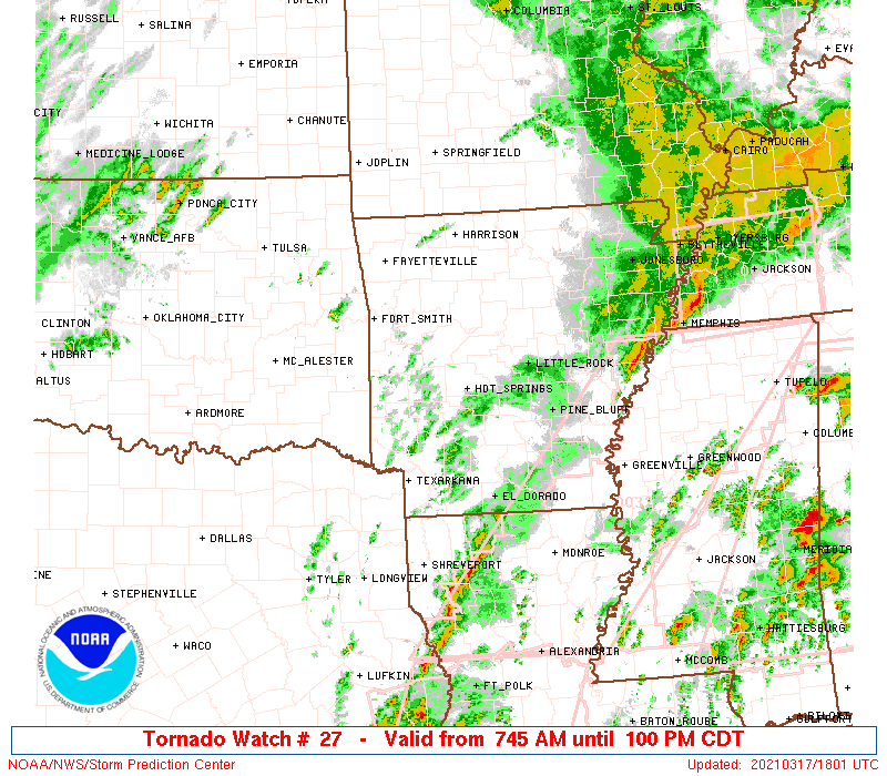
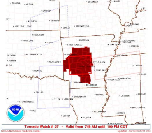
Tornado Watch Number 27
NWS Storm Prediction Center Norman OK
745 AM CDT Wed Mar 17 2021
The NWS Storm Prediction Center has issued a
* Tornado Watch for portions of
western and central Arkansas
* Effective this Wednesday morning and afternoon from 745 AM
until 100 PM CDT.
* Primary threats include...
A few tornadoes likely with a couple intense tornadoes possible
Scattered large hail likely with isolated very large hail events
to 2 inches in diameter possible
Scattered damaging wind gusts to 70 mph likely
SUMMARY...Strong/severe storms are forecast to spread northeastward
across the Arklatex and into western and central Arkansas over the
next couple of hours. In addition to potential for hail and locally
damaging winds, risk for a couple of tornadoes is also evident.
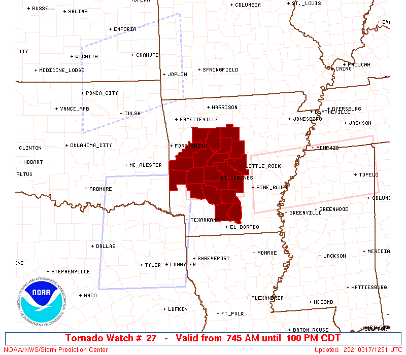
The tornado watch area is approximately along and 50 statute miles
east and west of a line from 50 miles north of Hot Springs AR to 35
miles south of Hot Springs AR. For a complete depiction of the watch
see the associated watch outline update (WOUS64 KWNS WOU7).
PRECAUTIONARY/PREPAREDNESS ACTIONS...
REMEMBER...A Tornado Watch means conditions are favorable for
tornadoes and severe thunderstorms in and close to the watch
area. Persons in these areas should be on the lookout for
threatening weather conditions and listen for later statements
and possible warnings.
&&
OTHER WATCH INFORMATION...CONTINUE...WW 24...WW 25...WW 26...
AVIATION...Tornadoes and a few severe thunderstorms with hail
surface and aloft to 2 inches. Extreme turbulence and surface wind
gusts to 60 knots. A few cumulonimbi with maximum tops to 500. Mean
storm motion vector 22035.
...Goss

   SEL7

   URGENT - IMMEDIATE BROADCAST REQUESTED
   Tornado Watch Number 27
   NWS Storm Prediction Center Norman OK
   745 AM CDT Wed Mar 17 2021

   The NWS Storm Prediction Center has issued a

   * Tornado Watch for portions of
     western and central Arkansas

   * Effective this Wednesday morning and afternoon from 745 AM
     until 100 PM CDT.

   * Primary threats include...
     A few tornadoes likely with a couple intense tornadoes possible
     Scattered large hail likely with isolated very large hail events
       to 2 inches in diameter possible
     Scattered damaging wind gusts to 70 mph likely

   SUMMARY...Strong/severe storms are forecast to spread northeastward
   across the Arklatex and into western and central Arkansas over the
   next couple of hours.  In addition to potential for hail and locally
   damaging winds, risk for a couple of tornadoes is also evident.

   The tornado watch area is approximately along and 50 statute miles
   east and west of a line from 50 miles north of Hot Springs AR to 35
   miles south of Hot Springs AR. For a complete depiction of the watch
   see the associated watch outline update (WOUS64 KWNS WOU7).

   PRECAUTIONARY/PREPAREDNESS ACTIONS...

   REMEMBER...A Tornado Watch means conditions are favorable for
   tornadoes and severe thunderstorms in and close to the watch
   area. Persons in these areas should be on the lookout for
   threatening weather conditions and listen for later statements
   and possible warnings.

   &&

   OTHER WATCH INFORMATION...CONTINUE...WW 24...WW 25...WW 26...

   AVIATION...Tornadoes and a few severe thunderstorms with hail
   surface and aloft to 2 inches. Extreme turbulence and surface wind
   gusts to 60 knots. A few cumulonimbi with maximum tops to 500. Mean
   storm motion vector 22035.

   ...Goss
 Note:
The Aviation Watch (SAW) product is an approximation to the watch area.
The actual watch is depicted by the shaded areas.
Note:
The Aviation Watch (SAW) product is an approximation to the watch area.
The actual watch is depicted by the shaded areas.
   SAW7
   WW 27 TORNADO AR 171245Z - 171800Z
   AXIS..50 STATUTE MILES EAST AND WEST OF LINE..
   50N HOT/HOT SPRINGS AR/ - 35S HOT/HOT SPRINGS AR/
   ..AVIATION COORDS.. 45NM E/W /55NW LIT - 46NNW ELD/
   HAIL SURFACE AND ALOFT..2 INCHES. WIND GUSTS..60 KNOTS.
   MAX TOPS TO 500. MEAN STORM MOTION VECTOR 22035.

   LAT...LON 35189221 33969223 33969397 35189399

   THIS IS AN APPROXIMATION TO THE WATCH AREA.  FOR A
   COMPLETE DEPICTION OF THE WATCH SEE WOUS64 KWNS
   FOR WOU7.
Watch 27 Status Report Messages:
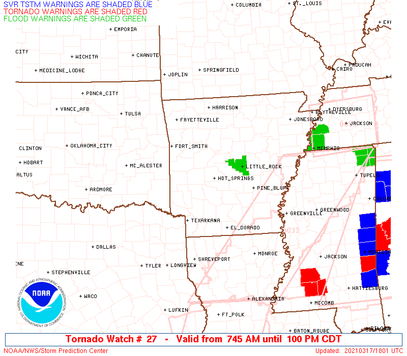
STATUS REPORT #3 ON WW 27

VALID 171645Z - 171740Z

SEVERE WEATHER THREAT CONTINUES RIGHT OF A LINE FROM 45 N ELD TO
15 ESE LIT.

..BENTLEY..03/17/21

ATTN...WFO...LZK...

&&

STATUS REPORT FOR WT 27

SEVERE WEATHER THREAT CONTINUES FOR THE FOLLOWING AREAS

ARC013-039-053-103-171740-

AR
.    ARKANSAS COUNTIES INCLUDED ARE

CALHOUN 	     DALLAS		 GRANT
OUACHITA
$$


THE WATCH STATUS MESSAGE IS FOR GUIDANCE PURPOSES ONLY.  PLEASE
REFER TO WATCH COUNTY NOTIFICATION STATEMENTS FOR OFFICIAL
INFORMATION ON COUNTIES...INDEPENDENT CITIES AND MARINE ZONES
CLEARED FROM SEVERE THUNDERSTORM AND TORNADO WATCHES.
$$

STATUS REPORT #2 ON WW 27

VALID 171455Z - 171540Z

SEVERE WEATHER THREAT CONTINUES RIGHT OF A LINE FROM 35 S HOT TO
25 N LIT.

..MOSIER..03/17/21

ATTN...WFO...LZK...

&&

STATUS REPORT FOR WT 27

SEVERE WEATHER THREAT CONTINUES FOR THE FOLLOWING AREAS

ARC013-019-039-053-103-119-171540-

AR
.    ARKANSAS COUNTIES INCLUDED ARE

CALHOUN 	     CLARK		 DALLAS
GRANT		     OUACHITA		 PULASKI
$$


THE WATCH STATUS MESSAGE IS FOR GUIDANCE PURPOSES ONLY.  PLEASE
REFER TO WATCH COUNTY NOTIFICATION STATEMENTS FOR OFFICIAL
INFORMATION ON COUNTIES...INDEPENDENT CITIES AND MARINE ZONES
CLEARED FROM SEVERE THUNDERSTORM AND TORNADO WATCHES.
$$

STATUS REPORT #1 ON WW 27

VALID 171355Z - 171440Z

SEVERE WEATHER THREAT CONTINUES RIGHT OF A LINE FROM 40 NNE TXK
TO 5 S RUE.

..MOSIER..03/17/21

ATTN...WFO...LZK...

&&

STATUS REPORT FOR WT 27

SEVERE WEATHER THREAT CONTINUES FOR THE FOLLOWING AREAS

ARC013-019-029-039-045-051-053-059-103-105-115-119-125-141-
171440-

AR
.    ARKANSAS COUNTIES INCLUDED ARE

CALHOUN 	     CLARK		 CONWAY
DALLAS		     FAULKNER		 GARLAND
GRANT		     HOT SPRING 	 OUACHITA
PERRY		     POPE		 PULASKI
SALINE		     VAN BUREN
$$


THE WATCH STATUS MESSAGE IS FOR GUIDANCE PURPOSES ONLY.  PLEASE
REFER TO WATCH COUNTY NOTIFICATION STATEMENTS FOR OFFICIAL
INFORMATION ON COUNTIES...INDEPENDENT CITIES AND MARINE ZONES
CLEARED FROM SEVERE THUNDERSTORM AND TORNADO WATCHES.
$$
Note:
Click for Complete Product Text.
Tornadoes
Probability of 2 or more tornadoes
|
High (70%)
|
Probability of 1 or more strong (EF2-EF5) tornadoes
|
Mod (50%)
|
Wind
Probability of 10 or more severe wind events
|
High (70%)
|
Probability of 1 or more wind events > 65 knots
|
Low (10%)
|
Hail
Probability of 10 or more severe hail events
|
High (70%)
|
Probability of 1 or more hailstones > 2 inches
|
Mod (30%)
|
Combined Severe Hail/Wind
Probability of 6 or more combined severe hail/wind events
|
High (90%)
|
For each watch, probabilities for particular events inside the watch
(listed above in each table) are determined by the issuing forecaster.
The "Low" category contains probability values ranging from less than 2%
to 20% (EF2-EF5 tornadoes), less than 5% to 20% (all other probabilities),
"Moderate" from 30% to 60%, and "High" from 70% to greater than 95%.
High values are bolded and lighter in color to provide awareness of
an increased threat for a particular event.


 @NWSSPC