 Note:
The expiration time in the watch graphic is amended if the watch is
replaced, cancelled or extended.
Note:
Note:
The expiration time in the watch graphic is amended if the watch is
replaced, cancelled or extended.
Note: Click for
Watch Status Reports.
SEL6
URGENT - IMMEDIATE BROADCAST REQUESTED
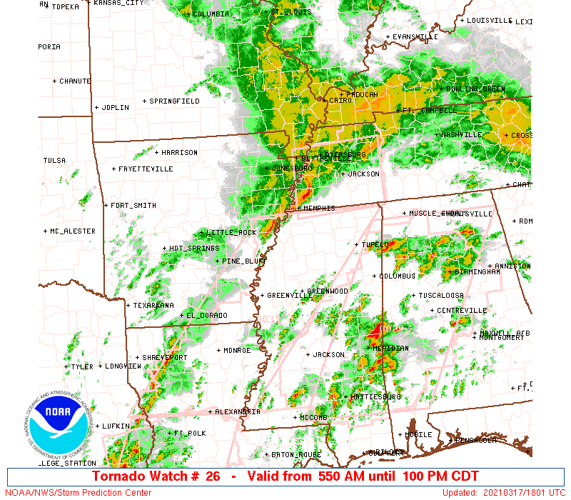
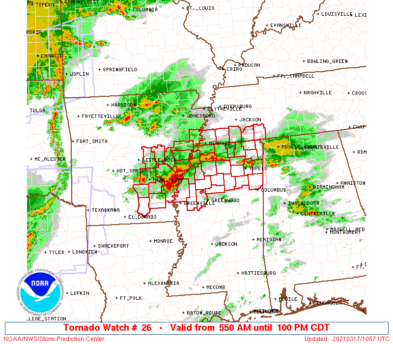
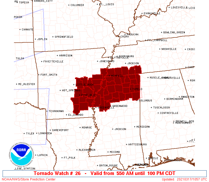
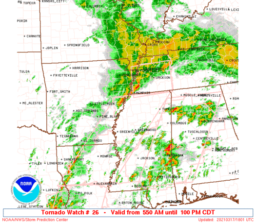
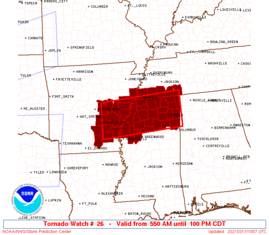
Tornado Watch Number 26
NWS Storm Prediction Center Norman OK
550 AM CDT Wed Mar 17 2021
The NWS Storm Prediction Center has issued a
* Tornado Watch for portions of
Southeast Arkansas
Northern Mississippi
Extreme southwest Tennessee
* Effective this Wednesday morning and afternoon from 550 AM
until 100 PM CDT.
* Primary threats include...
A few tornadoes likely with a couple intense tornadoes possible
Scattered large hail and isolated very large hail events to 2
inches in diameter possible
Scattered damaging wind gusts to 70 mph possible
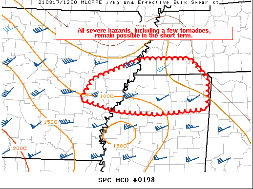
SUMMARY...Clusters of storms with embedded supercell structures will
likely persist through about midday from southeast Arkansas into
northern Mississippi and adjacent southwest Tennessee. The storm
environment will gradually become more favorable for a few tornadoes
this morning, including the possibility of an isolated strong
tornado. Otherwise, large hail and damaging winds can be expected
with the supercell clusters.
The tornado watch area is approximately along and 50 statute miles
north and south of a line from 5 miles north of Pine Bluff AR to 40
miles east northeast of Tupelo MS. For a complete depiction of the
watch see the associated watch outline update (WOUS64 KWNS WOU6).
PRECAUTIONARY/PREPAREDNESS ACTIONS...
REMEMBER...A Tornado Watch means conditions are favorable for
tornadoes and severe thunderstorms in and close to the watch
area. Persons in these areas should be on the lookout for
threatening weather conditions and listen for later statements
and possible warnings.
&&
OTHER WATCH INFORMATION...CONTINUE...WW 24...WW 25...
AVIATION...Tornadoes and a few severe thunderstorms with hail
surface and aloft to 2 inches. Extreme turbulence and surface wind
gusts to 60 knots. A few cumulonimbi with maximum tops to 500. Mean
storm motion vector 24035.
...Thompson

   SEL6

   URGENT - IMMEDIATE BROADCAST REQUESTED
   Tornado Watch Number 26
   NWS Storm Prediction Center Norman OK
   550 AM CDT Wed Mar 17 2021

   The NWS Storm Prediction Center has issued a

   * Tornado Watch for portions of
     Southeast Arkansas
     Northern Mississippi
     Extreme southwest Tennessee

   * Effective this Wednesday morning and afternoon from 550 AM
     until 100 PM CDT.

   * Primary threats include...
     A few tornadoes likely with a couple intense tornadoes possible
     Scattered large hail and isolated very large hail events to 2
       inches in diameter possible
     Scattered damaging wind gusts to 70 mph possible

   SUMMARY...Clusters of storms with embedded supercell structures will
   likely persist through about midday from southeast Arkansas into
   northern Mississippi and adjacent southwest Tennessee.  The storm
   environment will gradually become more favorable for a few tornadoes
   this morning, including the possibility of an isolated strong
   tornado.  Otherwise, large hail and damaging winds can be expected
   with the supercell clusters.

   The tornado watch area is approximately along and 50 statute miles
   north and south of a line from 5 miles north of Pine Bluff AR to 40
   miles east northeast of Tupelo MS. For a complete depiction of the
   watch see the associated watch outline update (WOUS64 KWNS WOU6).

   PRECAUTIONARY/PREPAREDNESS ACTIONS...

   REMEMBER...A Tornado Watch means conditions are favorable for
   tornadoes and severe thunderstorms in and close to the watch
   area. Persons in these areas should be on the lookout for
   threatening weather conditions and listen for later statements
   and possible warnings.

   &&

   OTHER WATCH INFORMATION...CONTINUE...WW 24...WW 25...

   AVIATION...Tornadoes and a few severe thunderstorms with hail
   surface and aloft to 2 inches. Extreme turbulence and surface wind
   gusts to 60 knots. A few cumulonimbi with maximum tops to 500. Mean
   storm motion vector 24035.

   ...Thompson
 Note:
The Aviation Watch (SAW) product is an approximation to the watch area.
The actual watch is depicted by the shaded areas.
Note:
The Aviation Watch (SAW) product is an approximation to the watch area.
The actual watch is depicted by the shaded areas.
   SAW6
   WW 26 TORNADO AR MS TN 171050Z - 171800Z
   AXIS..50 STATUTE MILES NORTH AND SOUTH OF LINE..
   5N PBF/PINE BLUFF AR/ - 40ENE TUP/TUPELO MS/
   ..AVIATION COORDS.. 45NM N/S /29SSE LIT - 34WSW MSL/
   HAIL SURFACE AND ALOFT..2 INCHES. WIND GUSTS..60 KNOTS.
   MAX TOPS TO 500. MEAN STORM MOTION VECTOR 24035.

   LAT...LON 34979193 35218812 33778812 33529193

   THIS IS AN APPROXIMATION TO THE WATCH AREA.  FOR A
   COMPLETE DEPICTION OF THE WATCH SEE WOUS64 KWNS
   FOR WOU6.
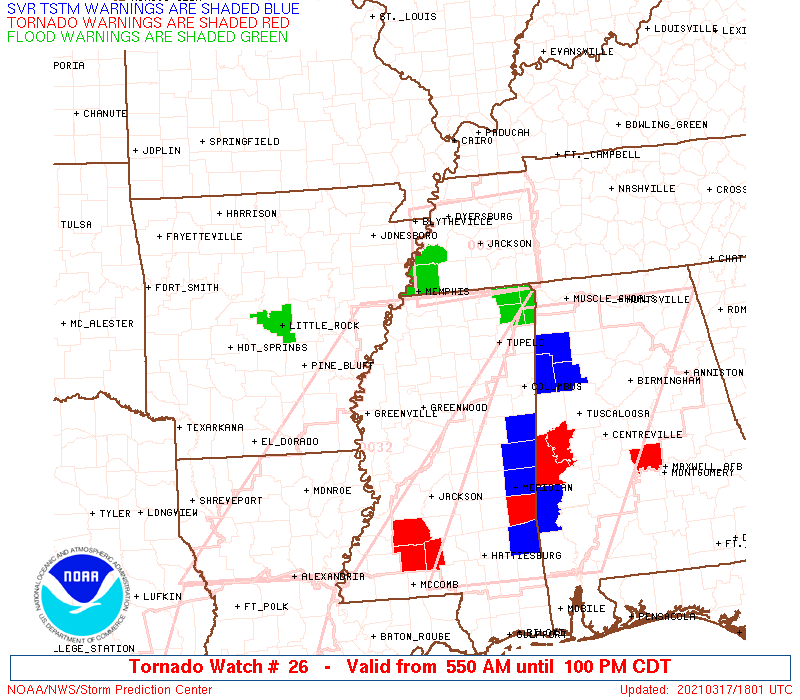
Watch 26 Status Report Messages:
STATUS REPORT #5 ON WW 26

VALID 171645Z - 171740Z

THE SEVERE WEATHER THREAT CONTINUES ACROSS THE ENTIRE WATCH AREA.

..BENTLEY..03/17/21

ATTN...WFO...LZK...MEG...JAN...

&&

STATUS REPORT FOR WT 26

SEVERE WEATHER THREAT CONTINUES FOR THE FOLLOWING AREAS

ARC001-011-025-035-041-043-069-077-079-085-095-107-117-123-
171740-

AR
.    ARKANSAS COUNTIES INCLUDED ARE

ARKANSAS	     BRADLEY		 CLEVELAND
CRITTENDEN	     DESHA		 DREW
JEFFERSON	     LEE		 LINCOLN
LONOKE		     MONROE		 PHILLIPS
PRAIRIE 	     ST. FRANCIS
$$


MSC003-009-011-013-017-027-033-043-057-071-081-083-093-095-107-
115-117-119-133-135-137-139-141-143-145-161-171740-

MS
.    MISSISSIPPI COUNTIES INCLUDED ARE

ALCORN		     BENTON		 BOLIVAR
CALHOUN 	     CHICKASAW		 COAHOMA
DESOTO		     GRENADA		 ITAWAMBA
LAFAYETTE	     LEE		 LEFLORE
MARSHALL	     MONROE		 PANOLA
PONTOTOC	     PRENTISS		 QUITMAN
SUNFLOWER	     TALLAHATCHIE	 TATE
TIPPAH		     TISHOMINGO 	 TUNICA
UNION		     YALOBUSHA
$$


TNC047-069-071-109-157-171740-

TN
.    TENNESSEE COUNTIES INCLUDED ARE

FAYETTE 	     HARDEMAN		 HARDIN
MCNAIRY 	     SHELBY
$$


THE WATCH STATUS MESSAGE IS FOR GUIDANCE PURPOSES ONLY.  PLEASE
REFER TO WATCH COUNTY NOTIFICATION STATEMENTS FOR OFFICIAL
INFORMATION ON COUNTIES...INDEPENDENT CITIES AND MARINE ZONES
CLEARED FROM SEVERE THUNDERSTORM AND TORNADO WATCHES.
$$

STATUS REPORT #4 ON WW 26

VALID 171455Z - 171540Z

THE SEVERE WEATHER THREAT CONTINUES ACROSS THE ENTIRE WATCH AREA.

..MOSIER..03/17/21

ATTN...WFO...LZK...MEG...JAN...

&&

STATUS REPORT FOR WT 26

SEVERE WEATHER THREAT CONTINUES FOR THE FOLLOWING AREAS

ARC001-011-025-035-041-043-069-077-079-085-095-107-117-123-
171540-

AR
.    ARKANSAS COUNTIES INCLUDED ARE

ARKANSAS	     BRADLEY		 CLEVELAND
CRITTENDEN	     DESHA		 DREW
JEFFERSON	     LEE		 LINCOLN
LONOKE		     MONROE		 PHILLIPS
PRAIRIE 	     ST. FRANCIS
$$


MSC003-009-011-013-017-027-033-043-057-071-081-083-093-095-107-
115-117-119-133-135-137-139-141-143-145-161-171540-

MS
.    MISSISSIPPI COUNTIES INCLUDED ARE

ALCORN		     BENTON		 BOLIVAR
CALHOUN 	     CHICKASAW		 COAHOMA
DESOTO		     GRENADA		 ITAWAMBA
LAFAYETTE	     LEE		 LEFLORE
MARSHALL	     MONROE		 PANOLA
PONTOTOC	     PRENTISS		 QUITMAN
SUNFLOWER	     TALLAHATCHIE	 TATE
TIPPAH		     TISHOMINGO 	 TUNICA
UNION		     YALOBUSHA
$$


TNC047-069-071-109-157-171540-

TN
.    TENNESSEE COUNTIES INCLUDED ARE

FAYETTE 	     HARDEMAN		 HARDIN
MCNAIRY 	     SHELBY
$$


THE WATCH STATUS MESSAGE IS FOR GUIDANCE PURPOSES ONLY.  PLEASE
REFER TO WATCH COUNTY NOTIFICATION STATEMENTS FOR OFFICIAL
INFORMATION ON COUNTIES...INDEPENDENT CITIES AND MARINE ZONES
CLEARED FROM SEVERE THUNDERSTORM AND TORNADO WATCHES.
$$

STATUS REPORT #3 ON WW 26

VALID 171405Z - 171540Z

THE SEVERE WEATHER THREAT CONTINUES ACROSS THE ENTIRE WATCH AREA.

..MOSIER..03/17/21

ATTN...WFO...LZK...MEG...JAN...

&&

STATUS REPORT FOR WT 26

SEVERE WEATHER THREAT CONTINUES FOR THE FOLLOWING AREAS

ARC001-011-025-035-041-043-069-077-079-085-095-107-117-123-
171540-

AR
.    ARKANSAS COUNTIES INCLUDED ARE

ARKANSAS	     BRADLEY		 CLEVELAND
CRITTENDEN	     DESHA		 DREW
JEFFERSON	     LEE		 LINCOLN
LONOKE		     MONROE		 PHILLIPS
PRAIRIE 	     ST. FRANCIS
$$


MSC003-009-011-013-017-027-033-043-057-071-081-083-093-095-107-
115-117-119-133-135-137-139-141-143-145-161-171540-

MS
.    MISSISSIPPI COUNTIES INCLUDED ARE

ALCORN		     BENTON		 BOLIVAR
CALHOUN 	     CHICKASAW		 COAHOMA
DESOTO		     GRENADA		 ITAWAMBA
LAFAYETTE	     LEE		 LEFLORE
MARSHALL	     MONROE		 PANOLA
PONTOTOC	     PRENTISS		 QUITMAN
SUNFLOWER	     TALLAHATCHIE	 TATE
TIPPAH		     TISHOMINGO 	 TUNICA
UNION		     YALOBUSHA
$$


TNC047-069-071-109-157-171540-

TN
.    TENNESSEE COUNTIES INCLUDED ARE

FAYETTE 	     HARDEMAN		 HARDIN
MCNAIRY 	     SHELBY
$$


THE WATCH STATUS MESSAGE IS FOR GUIDANCE PURPOSES ONLY.  PLEASE
REFER TO WATCH COUNTY NOTIFICATION STATEMENTS FOR OFFICIAL
INFORMATION ON COUNTIES...INDEPENDENT CITIES AND MARINE ZONES
CLEARED FROM SEVERE THUNDERSTORM AND TORNADO WATCHES.
$$

STATUS REPORT #2 ON WW 26

VALID 171230Z - 171340Z

THE SEVERE WEATHER THREAT CONTINUES ACROSS THE ENTIRE WATCH AREA.

..GLEASON..03/17/21

ATTN...WFO...LZK...MEG...JAN...

&&

STATUS REPORT FOR WT 26

SEVERE WEATHER THREAT CONTINUES FOR THE FOLLOWING AREAS

ARC001-011-025-035-041-043-069-077-079-085-095-107-117-123-
171340-

AR
.    ARKANSAS COUNTIES INCLUDED ARE

ARKANSAS	     BRADLEY		 CLEVELAND
CRITTENDEN	     DESHA		 DREW
JEFFERSON	     LEE		 LINCOLN
LONOKE		     MONROE		 PHILLIPS
PRAIRIE 	     ST. FRANCIS
$$


MSC003-009-011-013-017-027-033-043-057-071-081-083-093-095-107-
115-117-119-133-135-137-139-141-143-145-161-171340-

MS
.    MISSISSIPPI COUNTIES INCLUDED ARE

ALCORN		     BENTON		 BOLIVAR
CALHOUN 	     CHICKASAW		 COAHOMA
DESOTO		     GRENADA		 ITAWAMBA
LAFAYETTE	     LEE		 LEFLORE
MARSHALL	     MONROE		 PANOLA
PONTOTOC	     PRENTISS		 QUITMAN
SUNFLOWER	     TALLAHATCHIE	 TATE
TIPPAH		     TISHOMINGO 	 TUNICA
UNION		     YALOBUSHA
$$


TNC047-069-071-109-157-171340-

TN
.    TENNESSEE COUNTIES INCLUDED ARE

FAYETTE 	     HARDEMAN		 HARDIN
MCNAIRY 	     SHELBY
$$


THE WATCH STATUS MESSAGE IS FOR GUIDANCE PURPOSES ONLY.  PLEASE
REFER TO WATCH COUNTY NOTIFICATION STATEMENTS FOR OFFICIAL
INFORMATION ON COUNTIES...INDEPENDENT CITIES AND MARINE ZONES
CLEARED FROM SEVERE THUNDERSTORM AND TORNADO WATCHES.
$$

STATUS REPORT #1 ON WW 26

VALID 171200Z - 171340Z

THE SEVERE WEATHER THREAT CONTINUES ACROSS THE ENTIRE WATCH AREA.

..GLEASON..03/17/21

ATTN...WFO...LZK...MEG...JAN...

&&

STATUS REPORT FOR WT 26

SEVERE WEATHER THREAT CONTINUES FOR THE FOLLOWING AREAS

ARC001-011-025-035-041-043-069-077-079-085-095-107-117-123-
171340-

AR
.    ARKANSAS COUNTIES INCLUDED ARE

ARKANSAS	     BRADLEY		 CLEVELAND
CRITTENDEN	     DESHA		 DREW
JEFFERSON	     LEE		 LINCOLN
LONOKE		     MONROE		 PHILLIPS
PRAIRIE 	     ST. FRANCIS
$$


MSC003-009-011-013-017-027-033-043-057-071-081-083-093-095-107-
115-117-119-133-135-137-139-141-143-145-161-171340-

MS
.    MISSISSIPPI COUNTIES INCLUDED ARE

ALCORN		     BENTON		 BOLIVAR
CALHOUN 	     CHICKASAW		 COAHOMA
DESOTO		     GRENADA		 ITAWAMBA
LAFAYETTE	     LEE		 LEFLORE
MARSHALL	     MONROE		 PANOLA
PONTOTOC	     PRENTISS		 QUITMAN
SUNFLOWER	     TALLAHATCHIE	 TATE
TIPPAH		     TISHOMINGO 	 TUNICA
UNION		     YALOBUSHA
$$


TNC047-069-071-109-157-171340-

TN
.    TENNESSEE COUNTIES INCLUDED ARE

FAYETTE 	     HARDEMAN		 HARDIN
MCNAIRY 	     SHELBY
$$


THE WATCH STATUS MESSAGE IS FOR GUIDANCE PURPOSES ONLY.  PLEASE
REFER TO WATCH COUNTY NOTIFICATION STATEMENTS FOR OFFICIAL
INFORMATION ON COUNTIES...INDEPENDENT CITIES AND MARINE ZONES
CLEARED FROM SEVERE THUNDERSTORM AND TORNADO WATCHES.
$$
Note:
Click for Complete Product Text.
Tornadoes
Probability of 2 or more tornadoes
|
Mod (60%)
|
Probability of 1 or more strong (EF2-EF5) tornadoes
|
Mod (30%)
|
Wind
Probability of 10 or more severe wind events
|
Mod (50%)
|
Probability of 1 or more wind events > 65 knots
|
Low (10%)
|
Hail
Probability of 10 or more severe hail events
|
Mod (50%)
|
Probability of 1 or more hailstones > 2 inches
|
Mod (40%)
|
Combined Severe Hail/Wind
Probability of 6 or more combined severe hail/wind events
|
High (80%)
|
For each watch, probabilities for particular events inside the watch
(listed above in each table) are determined by the issuing forecaster.
The "Low" category contains probability values ranging from less than 2%
to 20% (EF2-EF5 tornadoes), less than 5% to 20% (all other probabilities),
"Moderate" from 30% to 60%, and "High" from 70% to greater than 95%.
High values are bolded and lighter in color to provide awareness of
an increased threat for a particular event.


 @NWSSPC