|
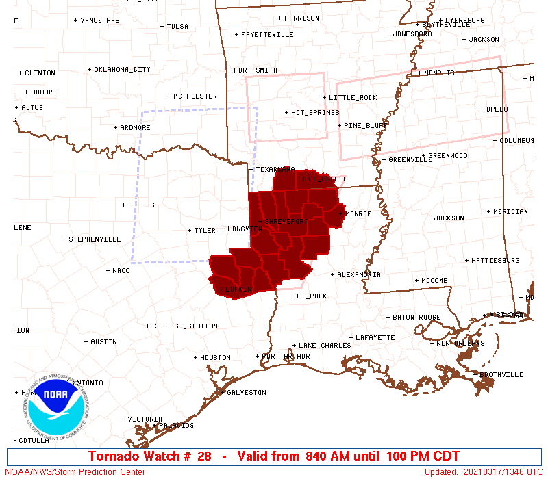
Initial List of Counties in SPC Tornado Watch 28 (WOU)
|
Back to Watch 28
|
 |
   WOUS64 KWNS 171338
   WOU8

   BULLETIN - IMMEDIATE BROADCAST REQUESTED
   TORNADO WATCH OUTLINE UPDATE FOR WT 28
   NWS STORM PREDICTION CENTER NORMAN OK
   840 AM CDT WED MAR 17 2021

   TORNADO WATCH 28 IS IN EFFECT UNTIL 100 PM CDT FOR THE
    FOLLOWING LOCATIONS

   ARC027-139-171800-
   /O.NEW.KWNS.TO.A.0028.210317T1340Z-210317T1800Z/

   AR
   .    ARKANSAS COUNTIES INCLUDED ARE

   COLUMBIA             UNION


   LAC013-015-017-027-031-049-061-069-073-081-085-111-119-127-
   171800-
   /O.NEW.KWNS.TO.A.0028.210317T1340Z-210317T1800Z/

   LA
   .    LOUISIANA PARISHES INCLUDED ARE

   BIENVILLE            BOSSIER             CADDO
   CLAIBORNE            DE SOTO             JACKSON
   LINCOLN              NATCHITOCHES        OUACHITA
   RED RIVER            SABINE              UNION
   WEBSTER              WINN


   TXC005-347-403-405-419-171800-
   /O.NEW.KWNS.TO.A.0028.210317T1340Z-210317T1800Z/

   TX
   .    TEXAS COUNTIES INCLUDED ARE

   ANGELINA             NACOGDOCHES         SABINE
   SAN AUGUSTINE        SHELBY


   ATTN...WFO...SHV...
|
| Aviation Watch (SAW) for WW28 |
|---|
 |
| Note:
The Aviation Watch (SAW) product is an approximation to the watch area.
The actual watch is depicted by the shaded areas. |
   SAW8
   WW 28 TORNADO AR LA TX 171340Z - 171800Z
   AXIS..45 STATUTE MILES EAST AND WEST OF LINE..
   10E ELD/EL DORADO AR/ - 55SW IER/NATCHITOCHES LA/
   ..AVIATION COORDS.. 40NM E/W /5ESE ELD - 49E LFK/
   HAIL SURFACE AND ALOFT..1.5 INCHES. WIND GUSTS..65 KNOTS.
   MAX TOPS TO 500. MEAN STORM MOTION VECTOR 26035.

   LAT...LON 33229187 31179300 31179452 33229343

   THIS IS AN APPROXIMATION TO THE WATCH AREA.  FOR A
   COMPLETE DEPICTION OF THE WATCH SEE WOUS64 KWNS
   FOR WOU8.
|
|


 @NWSSPC