 Note:
The expiration time in the watch graphic is amended if the watch is
replaced, cancelled or extended.
Note:
Note:
The expiration time in the watch graphic is amended if the watch is
replaced, cancelled or extended.
Note: Click for
Watch Status Reports.
SEL5
URGENT - IMMEDIATE BROADCAST REQUESTED
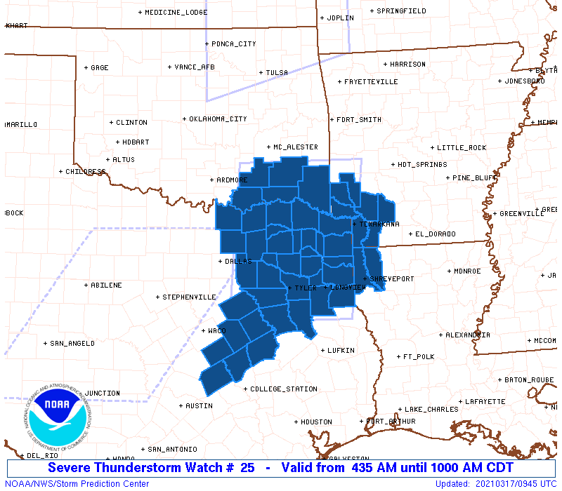
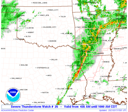
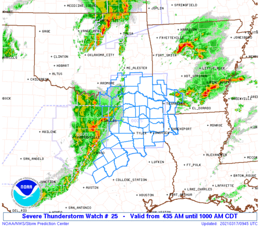
Severe Thunderstorm Watch Number 25
NWS Storm Prediction Center Norman OK
435 AM CDT Wed Mar 17 2021
The NWS Storm Prediction Center has issued a
* Severe Thunderstorm Watch for portions of
Southwest Arkansas
Extreme northwest Louisiana
Southeast Oklahoma
Northeast Texas
* Effective this Wednesday morning from 435 AM until 1000 AM CDT.
* Primary threats include...
Scattered damaging wind gusts to 70 mph possible
Scattered large hail events to 1.5 inches in diameter possible
A tornado or two possible
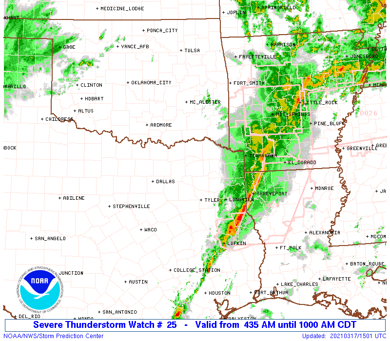
SUMMARY...A broken band of strong-severe storms will continue to
spread east-northeastward from the Dallas-Fort Worth area toward
Texarkana through the morning. Damaging winds and large hail will
be the main threats, but the storm environment still suggests some
potential for embedded circulations with a tornado or two possible.
The severe thunderstorm watch area is approximately along and 75
statute miles east and west of a line from 55 miles northwest of De
Queen AR to 40 miles south of Tyler TX. For a complete depiction of
the watch see the associated watch outline update (WOUS64 KWNS
WOU5).
PRECAUTIONARY/PREPAREDNESS ACTIONS...
REMEMBER...A Severe Thunderstorm Watch means conditions are
favorable for severe thunderstorms in and close to the watch area.
Persons in these areas should be on the lookout for threatening
weather conditions and listen for later statements and possible
warnings. Severe thunderstorms can and occasionally do produce
tornadoes.
&&
OTHER WATCH INFORMATION...CONTINUE...WW 23...WW 24...
AVIATION...A few severe thunderstorms with hail surface and aloft to
1.5 inches. Extreme turbulence and surface wind gusts to 60 knots. A
few cumulonimbi with maximum tops to 500. Mean storm motion vector
24040.
...Thompson
   SEL5

   URGENT - IMMEDIATE BROADCAST REQUESTED
   Severe Thunderstorm Watch Number 25
   NWS Storm Prediction Center Norman OK
   435 AM CDT Wed Mar 17 2021

   The NWS Storm Prediction Center has issued a

   * Severe Thunderstorm Watch for portions of
     Southwest Arkansas
     Extreme northwest Louisiana
     Southeast Oklahoma
     Northeast Texas

   * Effective this Wednesday morning from 435 AM until 1000 AM CDT.

   * Primary threats include...
     Scattered damaging wind gusts to 70 mph possible
     Scattered large hail events to 1.5 inches in diameter possible
     A tornado or two possible

   SUMMARY...A broken band of strong-severe storms will continue to
   spread east-northeastward from the Dallas-Fort Worth area toward
   Texarkana through the morning.  Damaging winds and large hail will
   be the main threats, but the storm environment still suggests some
   potential for embedded circulations with a tornado or two possible.

   The severe thunderstorm watch area is approximately along and 75
   statute miles east and west of a line from 55 miles northwest of De
   Queen AR to 40 miles south of Tyler TX. For a complete depiction of
   the watch see the associated watch outline update (WOUS64 KWNS
   WOU5).

   PRECAUTIONARY/PREPAREDNESS ACTIONS...

   REMEMBER...A Severe Thunderstorm Watch means conditions are
   favorable for severe thunderstorms in and close to the watch area.
   Persons in these areas should be on the lookout for threatening
   weather conditions and listen for later statements and possible
   warnings. Severe thunderstorms can and occasionally do produce
   tornadoes.

   &&

   OTHER WATCH INFORMATION...CONTINUE...WW 23...WW 24...

   AVIATION...A few severe thunderstorms with hail surface and aloft to
   1.5 inches. Extreme turbulence and surface wind gusts to 60 knots. A
   few cumulonimbi with maximum tops to 500. Mean storm motion vector
   24040.

   ...Thompson
 Note:
The Aviation Watch (SAW) product is an approximation to the watch area.
The actual watch is depicted by the shaded areas.
Note:
The Aviation Watch (SAW) product is an approximation to the watch area.
The actual watch is depicted by the shaded areas.
   SAW5
   WW 25 SEVERE TSTM AR LA OK TX 170935Z - 171500Z
   AXIS..75 STATUTE MILES EAST AND WEST OF LINE..
   55NW DEQ/DE QUEEN AR/ - 40S TYR/TYLER TX/
   ..AVIATION COORDS.. 65NM E/W /37ESE MLC - 51NW LFK/
   HAIL SURFACE AND ALOFT..1.5 INCHES. WIND GUSTS..60 KNOTS.
   MAX TOPS TO 500. MEAN STORM MOTION VECTOR 24040.

   LAT...LON 34599377 31769412 31769668 34599640

   THIS IS AN APPROXIMATION TO THE WATCH AREA.  FOR A
   COMPLETE DEPICTION OF THE WATCH SEE WOUS64 KWNS
   FOR WOU5.
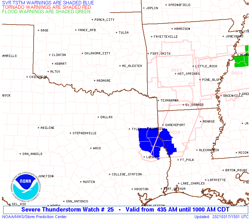
Watch 25 Status Report Messages:
STATUS REPORT #5 ON WW 25
VALID 171455Z - 171500Z
SEVERE WEATHER THREAT CONTINUES RIGHT OF A LINE FROM 35 N LFK TO
15 NW SHV.
WW 25 WILL BE ALLOWED TO EXPIRE AT 171500Z.
..MOSIER..03/17/21
ATTN...WFO...SHV...OUN...TSA...FWD...
&&
STATUS REPORT FOR WS 25
SEVERE WEATHER THREAT CONTINUES FOR THE FOLLOWING AREAS
ARC073-099-171500-
AR
. ARKANSAS COUNTIES INCLUDED ARE
LAFAYETTE NEVADA
$$
LAC015-017-171500-
LA
. LOUISIANA PARISHES INCLUDED ARE
BOSSIER CADDO
$$
TXC365-171500-
TX
. TEXAS COUNTIES INCLUDED ARE
PANOLA
$$
THE WATCH STATUS MESSAGE IS FOR GUIDANCE PURPOSES ONLY. PLEASE
REFER TO WATCH COUNTY NOTIFICATION STATEMENTS FOR OFFICIAL
INFORMATION ON COUNTIES...INDEPENDENT CITIES AND MARINE ZONES
CLEARED FROM SEVERE THUNDERSTORM AND TORNADO WATCHES.
$$
STATUS REPORT #4 ON WW 25
VALID 171350Z - 171440Z
SEVERE WEATHER THREAT CONTINUES RIGHT OF A LINE FROM 40 SSE TYR
TO 30 WSW TXK TO 20 NNE TXK.
..MOSIER..03/17/21
ATTN...WFO...SHV...OUN...TSA...FWD...
&&
STATUS REPORT FOR WS 25
SEVERE WEATHER THREAT CONTINUES FOR THE FOLLOWING AREAS
ARC057-073-091-099-171440-
AR
. ARKANSAS COUNTIES INCLUDED ARE
HEMPSTEAD LAFAYETTE MILLER
NEVADA
$$
TXC067-073-203-365-401-171440-
TX
. TEXAS COUNTIES INCLUDED ARE
CASS CHEROKEE HARRISON
PANOLA RUSK
$$
THE WATCH STATUS MESSAGE IS FOR GUIDANCE PURPOSES ONLY. PLEASE
REFER TO WATCH COUNTY NOTIFICATION STATEMENTS FOR OFFICIAL
INFORMATION ON COUNTIES...INDEPENDENT CITIES AND MARINE ZONES
CLEARED FROM SEVERE THUNDERSTORM AND TORNADO WATCHES.
$$
STATUS REPORT #3 ON WW 25
VALID 171225Z - 171340Z
SEVERE WEATHER THREAT CONTINUES RIGHT OF A LINE FROM 25 N CLL TO
40 SSW TYR TO 30 NW GGG TO 25 ESE PRX TO 30 SE RKR.
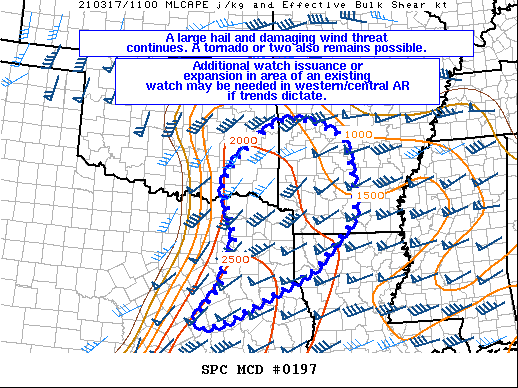
FOR ADDITIONAL INFORMATION SEE MESOSCALE DISCUSSION 197
..GLEASON..03/17/21
ATTN...WFO...SHV...OUN...TSA...FWD...
&&
STATUS REPORT FOR WS 25
SEVERE WEATHER THREAT CONTINUES FOR THE FOLLOWING AREAS
ARC057-061-073-081-091-099-133-171340-
AR
. ARKANSAS COUNTIES INCLUDED ARE
HEMPSTEAD HOWARD LAFAYETTE
LITTLE RIVER MILLER NEVADA
SEVIER
$$
LAC015-017-171340-
LA
. LOUISIANA PARISHES INCLUDED ARE
BOSSIER CADDO
$$
OKC089-171340-
OK
. OKLAHOMA COUNTIES INCLUDED ARE
MCCURTAIN
$$
TXC001-037-063-067-073-183-203-289-315-343-365-387-401-423-449-
459-171340-
TX
. TEXAS COUNTIES INCLUDED ARE
ANDERSON BOWIE CAMP
CASS CHEROKEE GREGG
HARRISON LEON MARION
MORRIS PANOLA RED RIVER
RUSK SMITH TITUS
UPSHUR
$$
THE WATCH STATUS MESSAGE IS FOR GUIDANCE PURPOSES ONLY. PLEASE
REFER TO WATCH COUNTY NOTIFICATION STATEMENTS FOR OFFICIAL
INFORMATION ON COUNTIES...INDEPENDENT CITIES AND MARINE ZONES
CLEARED FROM SEVERE THUNDERSTORM AND TORNADO WATCHES.
$$
STATUS REPORT #2 ON WW 25
VALID 171200Z - 171340Z
SEVERE WEATHER THREAT CONTINUES RIGHT OF A LINE FROM 20 WNW CLL
TO 40 NNW CLL TO 40 SE CRS TO 5 WNW TYR TO 40 S PRX TO 20 NNE PRX
TO 10 S MLC.
FOR ADDITIONAL INFORMATION SEE MESOSCALE DISCUSSION 197
..GLEASON..03/17/21
ATTN...WFO...SHV...OUN...TSA...FWD...
&&
STATUS REPORT FOR WS 25
SEVERE WEATHER THREAT CONTINUES FOR THE FOLLOWING AREAS
ARC057-061-073-081-091-099-133-171340-
AR
. ARKANSAS COUNTIES INCLUDED ARE
HEMPSTEAD HOWARD LAFAYETTE
LITTLE RIVER MILLER NEVADA
SEVIER
$$
LAC015-017-171340-
LA
. LOUISIANA PARISHES INCLUDED ARE
BOSSIER CADDO
$$
OKC023-089-127-171340-
OK
. OKLAHOMA COUNTIES INCLUDED ARE
CHOCTAW MCCURTAIN PUSHMATAHA
$$
TXC001-037-063-067-073-159-183-203-213-289-315-343-365-387-395-
401-423-449-459-499-171340-
TX
. TEXAS COUNTIES INCLUDED ARE
ANDERSON BOWIE CAMP
CASS CHEROKEE FRANKLIN
GREGG HARRISON HENDERSON
LEON MARION MORRIS
PANOLA RED RIVER ROBERTSON
RUSK SMITH TITUS
UPSHUR WOOD
$$
THE WATCH STATUS MESSAGE IS FOR GUIDANCE PURPOSES ONLY. PLEASE
REFER TO WATCH COUNTY NOTIFICATION STATEMENTS FOR OFFICIAL
INFORMATION ON COUNTIES...INDEPENDENT CITIES AND MARINE ZONES
CLEARED FROM SEVERE THUNDERSTORM AND TORNADO WATCHES.
$$
STATUS REPORT #1 ON WW 25
VALID 171040Z - 171140Z
THE SEVERE WEATHER THREAT CONTINUES ACROSS THE ENTIRE WATCH AREA.
..GLEASON..03/17/21
ATTN...WFO...SHV...OUN...TSA...FWD...
&&
STATUS REPORT FOR WS 25
SEVERE WEATHER THREAT CONTINUES FOR THE FOLLOWING AREAS
ARC057-061-073-081-091-099-133-171140-
AR
. ARKANSAS COUNTIES INCLUDED ARE
HEMPSTEAD HOWARD LAFAYETTE
LITTLE RIVER MILLER NEVADA
SEVIER
$$
LAC015-017-171140-
LA
. LOUISIANA PARISHES INCLUDED ARE
BOSSIER CADDO
$$
OKC005-013-023-089-127-171140-
OK
. OKLAHOMA COUNTIES INCLUDED ARE
ATOKA BRYAN CHOCTAW
MCCURTAIN PUSHMATAHA
$$
TXC001-037-063-067-073-085-119-145-147-159-161-181-183-203-213-
223-231-257-277-289-293-315-331-343-349-365-379-387-395-397-401-
423-449-459-467-499-171140-
TX
. TEXAS COUNTIES INCLUDED ARE
ANDERSON BOWIE CAMP
CASS CHEROKEE COLLIN
DELTA FALLS FANNIN
FRANKLIN FREESTONE GRAYSON
GREGG HARRISON HENDERSON
HOPKINS HUNT KAUFMAN
LAMAR LEON LIMESTONE
MARION MILAM MORRIS
NAVARRO PANOLA RAINS
RED RIVER ROBERTSON ROCKWALL
RUSK SMITH TITUS
UPSHUR VAN ZANDT WOOD
$$
THE WATCH STATUS MESSAGE IS FOR GUIDANCE PURPOSES ONLY. PLEASE
REFER TO WATCH COUNTY NOTIFICATION STATEMENTS FOR OFFICIAL
INFORMATION ON COUNTIES...INDEPENDENT CITIES AND MARINE ZONES
CLEARED FROM SEVERE THUNDERSTORM AND TORNADO WATCHES.
$$
Note:
Click for Complete Product Text.
Tornadoes
Probability of 2 or more tornadoes
|
Low (20%)
|
Probability of 1 or more strong (EF2-EF5) tornadoes
|
Low (5%)
|
Wind
Probability of 10 or more severe wind events
|
Mod (40%)
|
Probability of 1 or more wind events > 65 knots
|
Low (20%)
|
Hail
Probability of 10 or more severe hail events
|
Mod (40%)
|
Probability of 1 or more hailstones > 2 inches
|
Low (20%)
|
Combined Severe Hail/Wind
Probability of 6 or more combined severe hail/wind events
|
High (70%)
|
For each watch, probabilities for particular events inside the watch
(listed above in each table) are determined by the issuing forecaster.
The "Low" category contains probability values ranging from less than 2%
to 20% (EF2-EF5 tornadoes), less than 5% to 20% (all other probabilities),
"Moderate" from 30% to 60%, and "High" from 70% to greater than 95%.
High values are bolded and lighter in color to provide awareness of
an increased threat for a particular event.


 @NWSSPC