 Note:
The expiration time in the watch graphic is amended if the watch is
replaced, cancelled or extended.
Note:
Note:
The expiration time in the watch graphic is amended if the watch is
replaced, cancelled or extended.
Note: Click for
Watch Status Reports.
SEL4
URGENT - IMMEDIATE BROADCAST REQUESTED
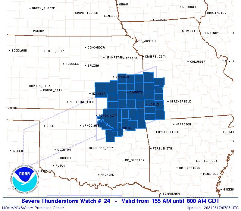
Severe Thunderstorm Watch Number 24
NWS Storm Prediction Center Norman OK
155 AM CDT Wed Mar 17 2021
The NWS Storm Prediction Center has issued a
* Severe Thunderstorm Watch for portions of
Southeast Kansas
Southwest Missouri
Northeast Oklahoma
* Effective this Wednesday morning from 155 AM until 800 AM CDT.
* Primary threats include...
Scattered large hail and isolated very large hail events to 2
inches in diameter possible
Scattered damaging wind gusts to 70 mph possible
A tornado or two possible
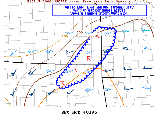
SUMMARY...Clusters of severe storms, some with supercell and/or
bowing structures, will continue to spread east-northeastward from
northern Oklahoma toward northeast Oklahoma, southeast Kansas, and
southwest Missouri through the early morning hours. Large hail can
be expected with the stronger storms, as well as occasional damaging
gusts. An isolated tornado cannot be ruled out later this morning
in northeast Oklahoma.
The severe thunderstorm watch area is approximately along and 75
statute miles north and south of a line from 5 miles north of Ponca
City OK to 45 miles northeast of Joplin MO. For a complete depiction
of the watch see the associated watch outline update (WOUS64 KWNS
WOU4).
PRECAUTIONARY/PREPAREDNESS ACTIONS...
REMEMBER...A Severe Thunderstorm Watch means conditions are
favorable for severe thunderstorms in and close to the watch area.
Persons in these areas should be on the lookout for threatening
weather conditions and listen for later statements and possible
warnings. Severe thunderstorms can and occasionally do produce
tornadoes.
&&
OTHER WATCH INFORMATION...CONTINUE...WW 22...WW 23...
AVIATION...A few severe thunderstorms with hail surface and aloft to
2 inches. Extreme turbulence and surface wind gusts to 60 knots. A
few cumulonimbi with maximum tops to 500. Mean storm motion vector
24035.
...Thompson
   SEL4

   URGENT - IMMEDIATE BROADCAST REQUESTED
   Severe Thunderstorm Watch Number 24
   NWS Storm Prediction Center Norman OK
   155 AM CDT Wed Mar 17 2021

   The NWS Storm Prediction Center has issued a

   * Severe Thunderstorm Watch for portions of
     Southeast Kansas
     Southwest Missouri
     Northeast Oklahoma

   * Effective this Wednesday morning from 155 AM until 800 AM CDT.

   * Primary threats include...
     Scattered large hail and isolated very large hail events to 2
       inches in diameter possible
     Scattered damaging wind gusts to 70 mph possible
     A tornado or two possible

   SUMMARY...Clusters of severe storms, some with supercell and/or
   bowing structures, will continue to spread east-northeastward from
   northern Oklahoma toward northeast Oklahoma, southeast Kansas, and
   southwest Missouri through the early morning hours.  Large hail can
   be expected with the stronger storms, as well as occasional damaging
   gusts.  An isolated tornado cannot be ruled out later this morning
   in northeast Oklahoma.

   The severe thunderstorm watch area is approximately along and 75
   statute miles north and south of a line from 5 miles north of Ponca
   City OK to 45 miles northeast of Joplin MO. For a complete depiction
   of the watch see the associated watch outline update (WOUS64 KWNS
   WOU4).

   PRECAUTIONARY/PREPAREDNESS ACTIONS...

   REMEMBER...A Severe Thunderstorm Watch means conditions are
   favorable for severe thunderstorms in and close to the watch area.
   Persons in these areas should be on the lookout for threatening
   weather conditions and listen for later statements and possible
   warnings. Severe thunderstorms can and occasionally do produce
   tornadoes.

   &&

   OTHER WATCH INFORMATION...CONTINUE...WW 22...WW 23...

   AVIATION...A few severe thunderstorms with hail surface and aloft to
   2 inches. Extreme turbulence and surface wind gusts to 60 knots. A
   few cumulonimbi with maximum tops to 500. Mean storm motion vector
   24035.

   ...Thompson
 Note:
The Aviation Watch (SAW) product is an approximation to the watch area.
The actual watch is depicted by the shaded areas.
Note:
The Aviation Watch (SAW) product is an approximation to the watch area.
The actual watch is depicted by the shaded areas.
   SAW4
   WW 24 SEVERE TSTM KS MO OK 170655Z - 171300Z
   AXIS..75 STATUTE MILES NORTH AND SOUTH OF LINE..
   5N PNC/PONCA CITY OK/ - 45NE JLN/JOPLIN MO/
   ..AVIATION COORDS.. 65NM N/S /48NE END - 32WNW SGF/
   HAIL SURFACE AND ALOFT..2 INCHES. WIND GUSTS..60 KNOTS.
   MAX TOPS TO 500. MEAN STORM MOTION VECTOR 24035.

   LAT...LON 37889710 38689392 36529392 35719710

   THIS IS AN APPROXIMATION TO THE WATCH AREA.  FOR A
   COMPLETE DEPICTION OF THE WATCH SEE WOUS64 KWNS
   FOR WOU4.
Watch 24 Status Report Messages:
STATUS REPORT #6 ON WW 24

VALID 171225Z - 171300Z

SEVERE WEATHER THREAT CONTINUES RIGHT OF A LINE FROM 25 SSW TUL
TO 20 NNW TUL TO 30 N UMN TO 30 SSW SZL.

WW 24 WILL BE ALLOWED TO EXPIRE AT 171300Z.

..GLEASON..03/17/21

ATTN...WFO...ICT...TOP...SGF...EAX...TSA...

&&

STATUS REPORT FOR WS 24

SEVERE WEATHER THREAT CONTINUES FOR THE FOLLOWING AREAS

MOC009-039-057-097-109-119-145-185-171300-

MO
.    MISSOURI COUNTIES INCLUDED ARE

BARRY		     CEDAR		 DADE
JASPER		     LAWRENCE		 MCDONALD
NEWTON		     ST. CLAIR
$$


OKC035-041-097-115-131-143-171300-

OK
.    OKLAHOMA COUNTIES INCLUDED ARE

CRAIG		     DELAWARE		 MAYES
OTTAWA		     ROGERS		 TULSA
$$


THE WATCH STATUS MESSAGE IS FOR GUIDANCE PURPOSES ONLY.  PLEASE
REFER TO WATCH COUNTY NOTIFICATION STATEMENTS FOR OFFICIAL
INFORMATION ON COUNTIES...INDEPENDENT CITIES AND MARINE ZONES
CLEARED FROM SEVERE THUNDERSTORM AND TORNADO WATCHES.
$$

STATUS REPORT #5 ON WW 24

VALID 171155Z - 171240Z

SEVERE WEATHER THREAT CONTINUES RIGHT OF A LINE FROM 20 ESE CQB
TO 25 SW BVO TO 25 ENE JLN TO 20 WNW SZL.

..GLEASON..03/17/21

ATTN...WFO...ICT...TOP...SGF...EAX...TSA...

&&

STATUS REPORT FOR WS 24

SEVERE WEATHER THREAT CONTINUES FOR THE FOLLOWING AREAS

MOC009-039-057-097-109-119-145-185-171240-

MO
.    MISSOURI COUNTIES INCLUDED ARE

BARRY		     CEDAR		 DADE
JASPER		     LAWRENCE		 MCDONALD
NEWTON		     ST. CLAIR
$$


OKC035-037-041-097-105-113-115-131-143-147-171240-

OK
.    OKLAHOMA COUNTIES INCLUDED ARE

CRAIG		     CREEK		 DELAWARE
MAYES		     NOWATA		 OSAGE
OTTAWA		     ROGERS		 TULSA
WASHINGTON
$$


THE WATCH STATUS MESSAGE IS FOR GUIDANCE PURPOSES ONLY.  PLEASE
REFER TO WATCH COUNTY NOTIFICATION STATEMENTS FOR OFFICIAL
INFORMATION ON COUNTIES...INDEPENDENT CITIES AND MARINE ZONES
CLEARED FROM SEVERE THUNDERSTORM AND TORNADO WATCHES.
$$

STATUS REPORT #4 ON WW 24

VALID 171040Z - 171140Z

SEVERE WEATHER THREAT CONTINUES RIGHT OF A LINE FROM 15 W CQB TO
20 WSW BVO TO 35 W JLN TO 30 NE CNU TO 15 ESE OJC.

..GLEASON..03/17/21

ATTN...WFO...ICT...TOP...SGF...EAX...TSA...

&&

STATUS REPORT FOR WS 24

SEVERE WEATHER THREAT CONTINUES FOR THE FOLLOWING AREAS

KSC011-021-037-107-171140-

KS
.    KANSAS COUNTIES INCLUDED ARE

BOURBON 	     CHEROKEE		 CRAWFORD
LINN
$$


MOC009-011-013-039-057-097-109-119-145-185-217-171140-

MO
.    MISSOURI COUNTIES INCLUDED ARE

BARRY		     BARTON		 BATES
CEDAR		     DADE		 JASPER
LAWRENCE	     MCDONALD		 NEWTON
ST. CLAIR	     VERNON
$$


OKC035-037-041-097-105-113-115-117-131-143-147-171140-

OK
.    OKLAHOMA COUNTIES INCLUDED ARE

CRAIG		     CREEK		 DELAWARE
MAYES		     NOWATA		 OSAGE
OTTAWA		     PAWNEE		 ROGERS
TULSA		     WASHINGTON
$$


THE WATCH STATUS MESSAGE IS FOR GUIDANCE PURPOSES ONLY.  PLEASE
REFER TO WATCH COUNTY NOTIFICATION STATEMENTS FOR OFFICIAL
INFORMATION ON COUNTIES...INDEPENDENT CITIES AND MARINE ZONES
CLEARED FROM SEVERE THUNDERSTORM AND TORNADO WATCHES.
$$

STATUS REPORT #3 ON WW 24

VALID 170945Z - 171040Z

SEVERE WEATHER THREAT CONTINUES RIGHT OF A LINE FROM 15 W CQB TO
35 NW BVO TO 20 ENE CNU TO 30 SW OJC.

..GLEASON..03/17/21

ATTN...WFO...ICT...TOP...SGF...EAX...TSA...

&&

STATUS REPORT FOR WS 24

SEVERE WEATHER THREAT CONTINUES FOR THE FOLLOWING AREAS

KSC011-019-021-037-099-107-125-133-205-171040-

KS
.    KANSAS COUNTIES INCLUDED ARE

BOURBON 	     CHAUTAUQUA 	 CHEROKEE
CRAWFORD	     LABETTE		 LINN
MONTGOMERY	     NEOSHO		 WILSON
$$


MOC009-011-013-039-057-097-109-119-145-185-217-171040-

MO
.    MISSOURI COUNTIES INCLUDED ARE

BARRY		     BARTON		 BATES
CEDAR		     DADE		 JASPER
LAWRENCE	     MCDONALD		 NEWTON
ST. CLAIR	     VERNON
$$


OKC035-037-041-097-105-113-115-117-131-143-147-171040-

OK
.    OKLAHOMA COUNTIES INCLUDED ARE

CRAIG		     CREEK		 DELAWARE
MAYES		     NOWATA		 OSAGE
OTTAWA		     PAWNEE		 ROGERS
TULSA		     WASHINGTON
$$


THE WATCH STATUS MESSAGE IS FOR GUIDANCE PURPOSES ONLY.  PLEASE
REFER TO WATCH COUNTY NOTIFICATION STATEMENTS FOR OFFICIAL
INFORMATION ON COUNTIES...INDEPENDENT CITIES AND MARINE ZONES
CLEARED FROM SEVERE THUNDERSTORM AND TORNADO WATCHES.
$$

STATUS REPORT #2 ON WW 24

VALID 170830Z - 170940Z

THE SEVERE WEATHER THREAT CONTINUES ACROSS THE ENTIRE WATCH AREA.

..GLEASON..03/17/21

ATTN...WFO...ICT...TOP...SGF...EAX...TSA...

&&

STATUS REPORT FOR WS 24

SEVERE WEATHER THREAT CONTINUES FOR THE FOLLOWING AREAS

KSC001-003-011-015-019-021-031-037-049-073-099-107-125-133-205-
207-170940-

KS
.    KANSAS COUNTIES INCLUDED ARE

ALLEN		     ANDERSON		 BOURBON
BUTLER		     CHAUTAUQUA 	 CHEROKEE
COFFEY		     CRAWFORD		 ELK
GREENWOOD	     LABETTE		 LINN
MONTGOMERY	     NEOSHO		 WILSON
WOODSON
$$


MOC009-011-013-039-057-097-109-119-145-185-217-170940-

MO
.    MISSOURI COUNTIES INCLUDED ARE

BARRY		     BARTON		 BATES
CEDAR		     DADE		 JASPER
LAWRENCE	     MCDONALD		 NEWTON
ST. CLAIR	     VERNON
$$


OKC035-037-041-097-105-113-115-117-131-143-147-170940-

OK
.    OKLAHOMA COUNTIES INCLUDED ARE

CRAIG		     CREEK		 DELAWARE
MAYES		     NOWATA		 OSAGE
OTTAWA		     PAWNEE		 ROGERS
TULSA		     WASHINGTON
$$


THE WATCH STATUS MESSAGE IS FOR GUIDANCE PURPOSES ONLY.  PLEASE
REFER TO WATCH COUNTY NOTIFICATION STATEMENTS FOR OFFICIAL
INFORMATION ON COUNTIES...INDEPENDENT CITIES AND MARINE ZONES
CLEARED FROM SEVERE THUNDERSTORM AND TORNADO WATCHES.
$$

STATUS REPORT #1 ON WW 24

VALID 170745Z - 170840Z

THE SEVERE WEATHER THREAT CONTINUES ACROSS THE ENTIRE WATCH AREA.

..GLEASON..03/17/21

ATTN...WFO...ICT...TOP...SGF...EAX...TSA...

&&

STATUS REPORT FOR WS 24

SEVERE WEATHER THREAT CONTINUES FOR THE FOLLOWING AREAS

KSC001-003-011-015-019-021-031-037-049-073-099-107-125-133-205-
207-170840-

KS
.    KANSAS COUNTIES INCLUDED ARE

ALLEN		     ANDERSON		 BOURBON
BUTLER		     CHAUTAUQUA 	 CHEROKEE
COFFEY		     CRAWFORD		 ELK
GREENWOOD	     LABETTE		 LINN
MONTGOMERY	     NEOSHO		 WILSON
WOODSON
$$


MOC009-011-013-039-057-097-109-119-145-185-217-170840-

MO
.    MISSOURI COUNTIES INCLUDED ARE

BARRY		     BARTON		 BATES
CEDAR		     DADE		 JASPER
LAWRENCE	     MCDONALD		 NEWTON
ST. CLAIR	     VERNON
$$


OKC035-037-041-097-105-113-115-117-131-143-147-170840-

OK
.    OKLAHOMA COUNTIES INCLUDED ARE

CRAIG		     CREEK		 DELAWARE
MAYES		     NOWATA		 OSAGE
OTTAWA		     PAWNEE		 ROGERS
TULSA		     WASHINGTON
$$


THE WATCH STATUS MESSAGE IS FOR GUIDANCE PURPOSES ONLY.  PLEASE
REFER TO WATCH COUNTY NOTIFICATION STATEMENTS FOR OFFICIAL
INFORMATION ON COUNTIES...INDEPENDENT CITIES AND MARINE ZONES
CLEARED FROM SEVERE THUNDERSTORM AND TORNADO WATCHES.
$$
Note:
Click for Complete Product Text.
Tornadoes
Probability of 2 or more tornadoes
|
Low (20%)
|
Probability of 1 or more strong (EF2-EF5) tornadoes
|
Low (<2%)
|
Wind
Probability of 10 or more severe wind events
|
Mod (40%)
|
Probability of 1 or more wind events > 65 knots
|
Low (20%)
|
Hail
Probability of 10 or more severe hail events
|
Mod (40%)
|
Probability of 1 or more hailstones > 2 inches
|
Mod (40%)
|
Combined Severe Hail/Wind
Probability of 6 or more combined severe hail/wind events
|
High (70%)
|
For each watch, probabilities for particular events inside the watch
(listed above in each table) are determined by the issuing forecaster.
The "Low" category contains probability values ranging from less than 2%
to 20% (EF2-EF5 tornadoes), less than 5% to 20% (all other probabilities),
"Moderate" from 30% to 60%, and "High" from 70% to greater than 95%.
High values are bolded and lighter in color to provide awareness of
an increased threat for a particular event.


 @NWSSPC